|
Wild Roller Coaster of Warmth, Cold, Wind, Snow and Fire Weather |
|
 |
|
| Temperatures at 9 pm on Friday (16 December 2016). | |
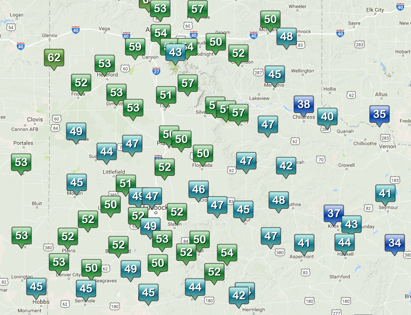
| Mid-December brought a wide and wild array of weather to West Texas. This occurred as a complex and potent western storm system approached and bitterly cold air plunged southward out of Canada. Ahead of both the storm system and cold front, gusty southwesterly winds provided very warm weather on Friday (December 16th). Both Lubbock and Childress set record highs when then reached 78 and 85, respectively. The below plot shows the highs recorded by the West Texas Mesonet from around the region on the 16th. | |
 |
|
| High temperatures observed by the West Texas Mesonet on Friday, December 16th, 2016. | |
| The large storm system (captured by the below water vapor animation) that brought the wind to the region also dropped feet of snow as it moved across the Intermountain West. | |
 |
|
| Water vapor animation valid from 5:45 am to 4:45 pm on 17 December 2016 (Saturday). | |
| A sharp cold front, with air originating from the land of 24-hour darkness this time of year, then marched steadily southwestward across the South Plains during the day Saturday. Ahead of front temperatures were amazingly mild for mid-December, but they came crashing down immediately behind the front. During Saturday afternoon temperatures ranged of the 70s and 80s ahead of the front to 20s almost immediately behind the front, with teens and single digits not far behind. | |
 |
 |
| Maximum wind gust observed by the West Texas Mesonet on 16 December (left) and 17 December (right) 2016. | |
| Strong north winds, generally sustained in the 20-30 mph range, carried in the icebox-like air. Even stronger winds, gusting above 60 mph, was common ahead of the front across southeast New Mexico into the southwest South Plains. The winds were further enhanced immediately along the front from Plains to Denver City and Seagraves were gusts exceed 70 mph. The West Texas Mesonet site near Denver City recorded an extreme gust of 79 mph. To view a meteogram from the Denver City site CLICK HERE. A complete listing of the Preliminary Storm Reports can be VIEWED HERE. | |
 |
|
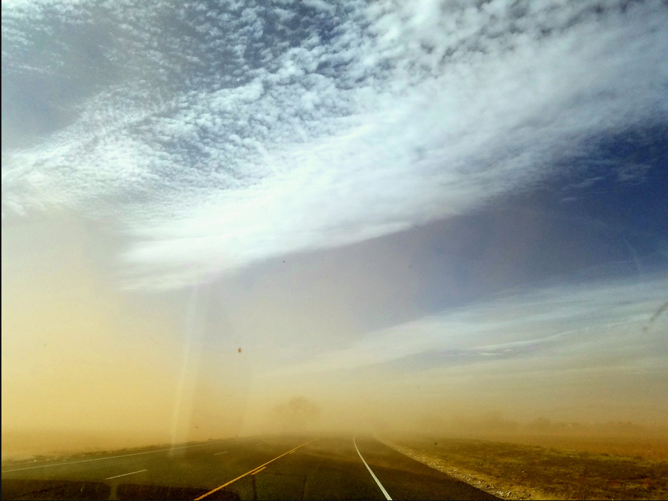
| Blowing dusts observed along Highway 380 on 17 December 2016. Image is courtesy of @AnnHD04. | |
| The strong winds lofted copious amounts of dust, creating brownout conditions in spots. The winds also damaged trees, power lines and several structures in and around the Denver City. | |
 |
|
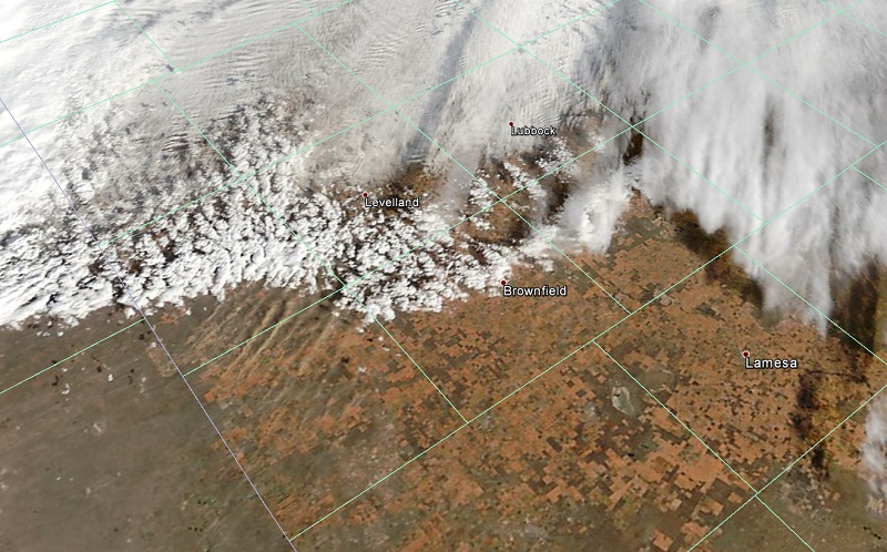
| A satellite image Saturday afternoon focused in on the southwest South Plains where you can see the interface of the cold front (indicated by the line of clouds) and the very strong southwesterly winds (visualized by the parallel lines of blowing dust to the immediate south of the front). | |
 |
|
| Structure fire in Wilson on 17 December 2016. The picture is courtesy of KAMC. | |
| Unfortunately, the strong, warm and relatively dry winds also fueled several fires across the region on Friday and Saturday, including a structure fire in Wilson. | |
 |
|
| Regional radar animation valid from 3:08 to 4:18 pm on 17 December 2016. | |
| After the cold front moved through a brief round of lift spread from west to east across northwest Texas. Although moisture starved, the lift was strong enough to squeeze out a quick shot of sleet and snow Saturday afternoon. The sleet and snow totals were on the light side, with most spots from the central South and Rolling Plains into the southern Texas Panhandle recording a dusting to a half of an inch. A couple of exceptions were Friona and Hart where an inch of snow was observed. | |
 |
 |
| Residual sleet and snow in Amherst (left) and Muleshoe (right). The Muleshoe image is courtesy of Roy Rice. | |
| In addition to the light wintry precipitation, temperatures falling into the single digits combine with breezy north winds to create dangerous wind chills Saturday afternoon into early Sunday morning. Wind chill values of -5 to -15 degrees were quite common, with even lower readings occasionally observed across the southwest Texas Panhandle. | |
 |
|
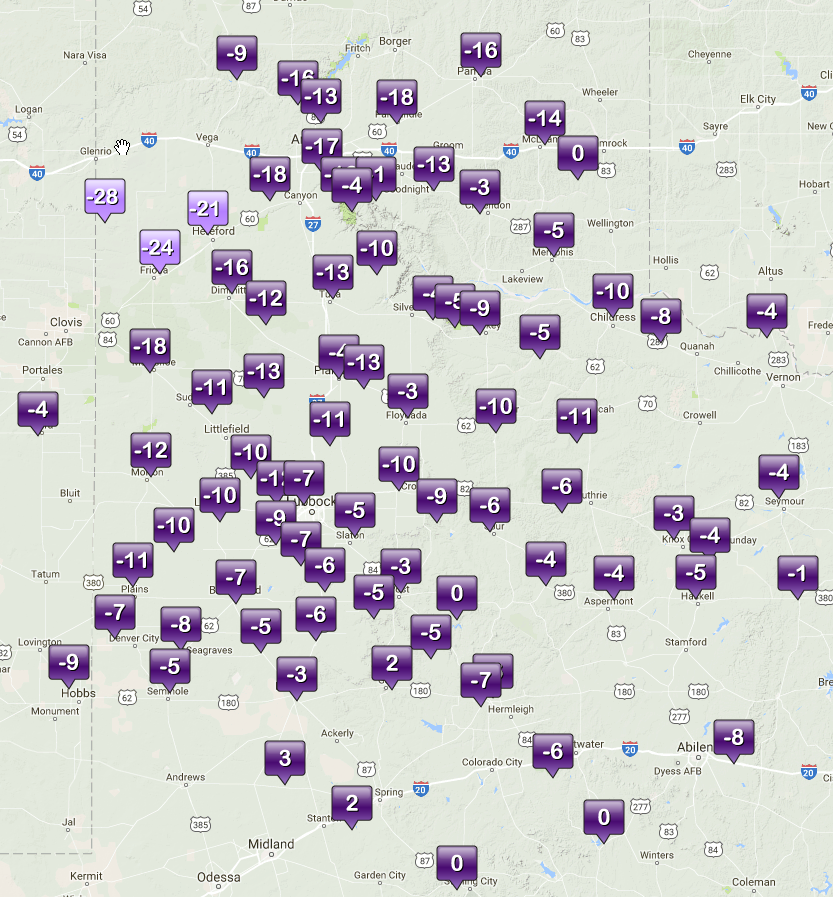
| Wind chill values observed by the West Texas Mesonet at 5 am 18 December 2016 (Sunday). | |
| Lows by early Sunday morning bottomed out in the single digits for most spots. Lubbock officially dipped to 4 degrees, setting a new record low for the 18th (previous record was 6 degrees set in 1996). Childress also tied their record low of 7 degrees (initially set in 1983). The 4°F temperature was the coldest recorded at Lubbock since February 10th of 2011. Not to be outdone, the West Texas Mesonet site near Friona dropped to an astonishing -10°F. | |

