| Wednesday Brings the Wind! 23 March 2016 |
 |
| Dusty sky at the Lubbock Airport during the afternoon of March 23rd, 2016. For a zoomed-in view of the dusty seen at the airport CLICK HERE. |
| A vigorous early Spring storm system swept out of the Rockies and into the plains on Wednesday. This storm brought a blizzard to parts of eastern Colorado, large wildfires in the eastern Texas Panhandle and southern Kansas, and severe thunderstorms to southern Oklahoma and North Texas. Across the South Plains of West Texas, it brought strong winds and blowing dust. The map below shows a satellite overview of the large area affected by the storm system. |
 |
| MODIS satellite image from the afternoon of 23 March 2016. The imagery is courtesy of NASA. Click on the image to enlarge. |
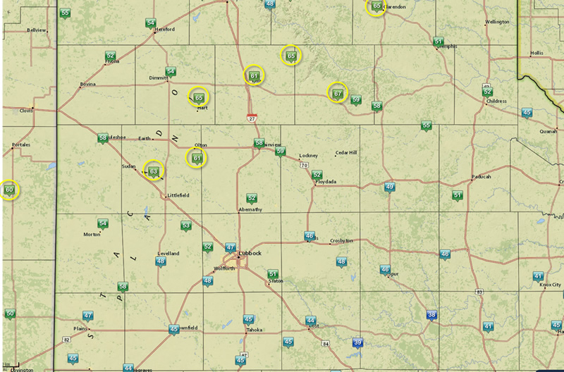
| The map below shows the peak wind gusts recorded across the area on Wednesday. In general, the strongest winds were located on the Caprock from eastern New Mexico across the northern South Plains and southern Texas Panhandle. A peak gust of 67 mph was observed by the West Texas Mesonet near Silverton. |
 |
| Map showing the peak wind gusts across the region on Wednesday, March 23, 2016. Wind gust speeds of 60 mph and higher are circled. Data is courtesy of the West Texas Mesonet. Click on the image to enlarge. |
| The below satellite loop illustrates how expansive the storm system was that affected the mid-section of the nation on the 23rd. Impacts were diverse, ranging from blizzard conditions to extreme fire weather (and 60+ mph wind gusts) to severe thunderstorms. |
 |
| Water vapor satellite loop valid from 1:15 am to 12:45 pm on 23 March 2016. The imagery is courtesy of the College of DuPage. An additional visible satellite loop valid from 3:44 to 6:45 pm can be VIEWED HERE. |
| The following radar imagery shows developing thunderstorms, some which became severe, across far North Texas into southern Oklahoma during the evening hours. In addition, there is a large plume of radar echoes emanating from near the Oklahoma and Kansas border. Amazingly, this plume was from a wildfire that was rapidly consuming large portions of land, driven by very strong, warm and dry winds. Lastly, a subtle fine line can be seen advancing southward through the southern Texas Panhandle, where a strong cold front was moving through with gusty northwesterly winds in its wake. |
 |
| Regional radar animation valid from 5:38 pm to 6:48 pm on 23 March 2016. The large echo in southern Kansas is from a wildfire complex. Storms can also be seen erupting along the dryline/front over North Texas into southern Oklahoma. |
| The final image below clearly shows several "hot spots" (bright white pixels) where wildfires are raging from the eastern Texas Panhandle into western Oklahoma and southern Kansas. The leading edge of the cold front is also clearly visible with a line of cumulus stretching from northeast New Mexico into the Texas Panhandle then arching into southwest Kansas. |
 |
| Shortwave satellite image captured at 2:45 pm on 23 March 2016. The yellows, oranges and purples are cold, high cloud tops. The very bright white areas in the eastern Texas Panhandle as well as from northern Oklahoma to southern Kansas are "hot spots" where wildfires are ongoing. Most of the remainder of the dull white is thin cloud cover. Additionally, a visible satellite image captured at the same time can be VIEWED HERE. |