| Thanksgiving Weekend Ice Storm 26-29 November 2015 |
||||
 |
||||
| Ice accumulations at Caprock Canyons State Park on November 28, 2015. | ||||
| Thanksgiving day started out on the warm side, with afternoon highs peaking in the lower to middle 70s for most of the South Plains and Rolling Plains. However, the weather took a drastic turn toward the colder side as a front plunged southward through the region during the late afternoon and evening hours. Temperatures tumbled down into the 30s by late evening, with sub-freezing temperatures invading the southwest Texas Panhandle and northern South Plains. | ||||
 |
||||
| Regional radar animation valid from 7:08 to 8:18 pm on Thursday, 26 November 2015 (Thanksgiving Day). An additional radar animation valid from 4:48 am to 5:58 am on Friday, 27 November 2015 can be FOUND HERE. | ||||
| The combination of Gulf moisture streaming in from the south, eastern Pacific Ocean moisture racing in from the southwest, a storm system gathering across the Great Basin and lift with the cold front resulted in scattered shower and thunderstorm development on Thanksgiving. Initially, the greatest concentration of activity was across the Texas Panhandle, though showers blossomed further south through the overnight hours. Strong southwesterly flow aloft kept temperatures well above freezing several thousand feet above the ground even as the mercury dipped below the freezing mark at ground level. This resulted in a change over from rain to freezing rain as the cold air built in on gusty northerly winds at ground level. The freezing rain even mixed with sleet at times as the cold air deepened, though the warm air aloft never completely gave way. A few spots even saw a little snow briefly mix in, though snow accumulations were minimal. | ||||
 |
||||
| Water vapor imagery captured from space at 8:15 pm on Friday, 27 November 2015. A large amount of moisture can be seen streaming across Texas from the southwest. A visible satellite image taken at 4:45 pm on the 27th can be VIEWED HERE. | ||||
| The freezing line continued to advance southward on Friday, with temperatures over the remainder of the South Plains and Rolling Plains dropping to and below the 32 degree mark. Periods of frozen precipitation continued through Friday and Friday night and right on into Saturday as relatively warm and moist air was repeated lifted over the cold low-level air, where temperatures were stuck in the 20s and lower 30s. In addition, a little bit of high level moisture also streamed into the system from Hurricane Sandra, in the eastern Pacific. | ||||
 |
||||
| Infrared satellite loop of Hurricane Sandra, in the eastern Pacific Ocean, from 1 pm to 8:30 pm on Thanksgiving (26 November 2015). | ||||
| Interestingly, Hurricane Sandra quickly strengthened to Category 4 storm on November 26th, making it the latest Category 4 hurricane on record in either the eastern Pacific or Atlantic basins, surpassing Hurricane Kenneth (22 November 2011). Sandra was also the strongest hurricane so late in the season and the second latest forming hurricane on record. Amazingly, Sandra became the 30th Category 3+ tropical cyclone of 2015 in the Northern Hemisphere, outpacing the previous record of 23 such storms in 1997 and 2004. Sandra weakened just as fast as it developed with its remnants moving into the Mexican coast November 28th. Although Sandra did contribute a little high level moisture to the region, the bulk of the moisture in West Texas came from the Gulf and a fetch of Pacific moisture carried by a strong sub-tropical jet located north of the hurricane. | ||||
 |
||||
| Regional radar animation valid from 9:38 to 10:48 pm on Friday, 27 November 2015. Additional radar animations are available at: 6:08 pm to 7:18 pm on Friday, 27 November 2015; and 4:48 am to 5:58 am on Saturday, 28 November 2015. | ||||
| The near record moisture levels for late November also contributed to heavy rain for much of North Texas into southeast Oklahoma and western Arkansas, where some spots recorded a half foot to a foot of rain. This rain resulted in extensive flooding and also contributed to several deaths. | ||||
|
||||
| Views of ice accumulations in southwest Lubbock. The right image is courtesy of @imnotycobb. | ||||
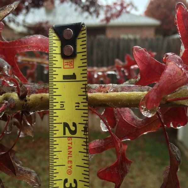
| Here in West Texas, the prolonged stretch of freezing rain, sleet and freezing drizzle did result in significant accumulations of ice, particularly on elevated surfaces including trees, grasses, power lines, bridges and overpasses. The weight of the ice did damage some vegetation and knock out power in spots. The slick conditions also contributed to a number of vehicle accidents around the region. Luckily, though, where temperatures stayed within a few degrees of the freezing mark, roughly from Lubbock south and eastward, surface roads stayed mostly wet which helped to mitigate the overall impacts. A listing of the preliminary storm reports for the icing event can be FOUND HERE. | ||||
 |
||||
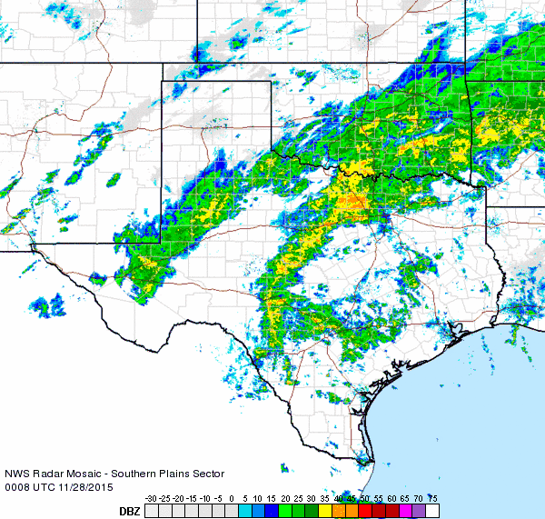
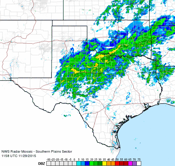
| Regional radar animation valid from 6:58 pm to 8:08 pm on Saturday, 28 November 2015. An additional radar animation valid from 5:58 am to 7:08 am on Sunday, 29 November 2015 can be FOUND HERE. | ||||
| Temperatures were nearly flat lined from Friday into Saturday as thick clouds persisted, with readings finally edging up to around freezing late Saturday, then slightly above freezing by Sunday, though low clouds held tough. One final night of clouds, fog and a cold drizzle rounded out the holiday weekend before the moisture was finally scoured out on Monday, with a return to sun and temperatures rising out of the 30s and peaking in the 50s for most spots. | ||||
 |
||||
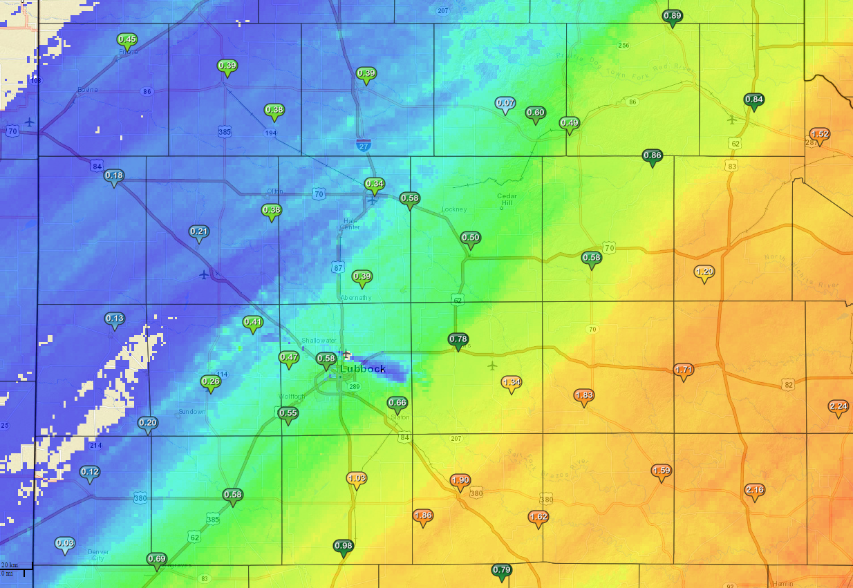
| Four-day radar-estimated and bias-corrected rain totals ending at 7 pm on Sunday, 29 November 2015. Click on the picture for a close up version centered on the South Plains region. Another region look at the precipitation totals, complete with some measured data can be VIEWED HERE. | ||||
|
Over the courses of the chilly, damp and cloudy weekend, a good amount of precipitation did fall on the South Plains region. Liquid water equivalents ranged from a tenth to quarter inch near the Texas/New Mexico line to over two inches across the southern Rolling Plains. The Lubbock airport officially recorded 0.70 inches over the 5-day period of November 26th through the 30th. |
||||


