 |
 |
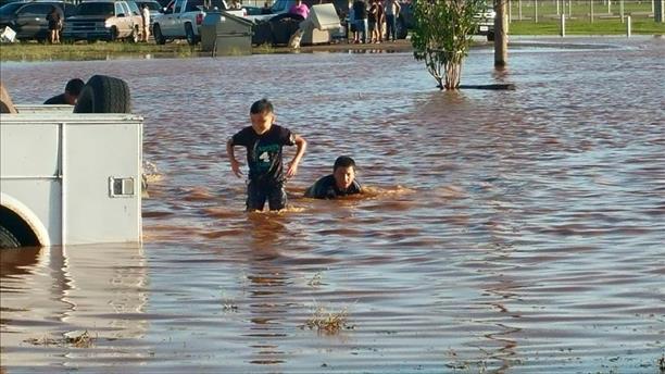
| Maxey Lake claiming extra land in central Lubbock on May 5, 2015. The picture was taken looking out of the third floor of Covenant Lakeside. The image is courtesy of KCBD. |
| |
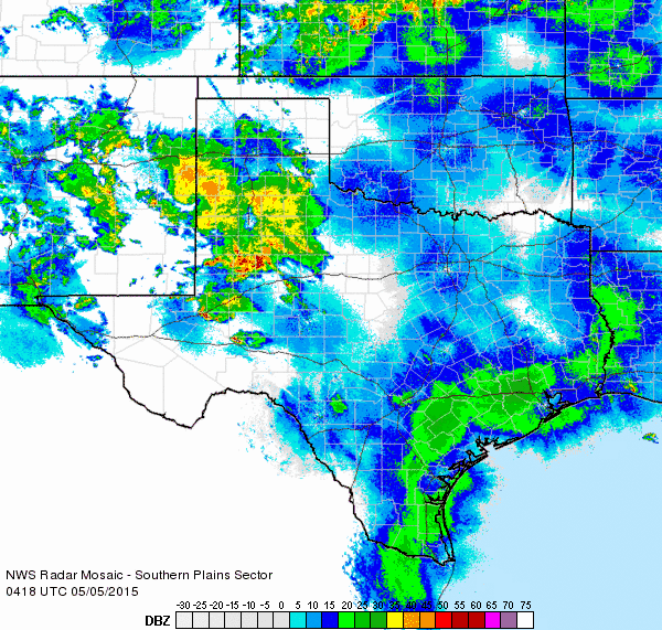
| A strong upper level storm system spinning across the southwesterly United States combined with abundant moisture to bring widespread rain to West Texas early this May. The action kicked off on Sunday, May 3rd, when scattered thunderstorms fired over the western South Plains. Moisture was still relatively meager so the overall rainfall coverage and intensity was limited, though a few storms did become strong and severe and produce damaging wind gusts and small hail. Levelland was the hardest hit where quarter size hail and wind gusts estimated to 70 mph produced some damage. |
| |
 |
| Lubbock WSR-88D radar animation valid from 5:52 to 9:11 pm on Monday, May 4, 2015. |
| |
| The main show really kicked off the next day when moisture increased substantially and interacted with a couple of strong upper level disturbances ahead of the western storm system. Showers and thunderstorms blossomed during the afternoon of the 4th (Monday). A few of these storms did produce small hail and gusty winds, but widespread heavy rain was their primary mode. The most persistent and heavy rain fell across the central and southern South Plains into the northern Permian Basin during the afternoon and evening hours (see the above radar animation). Rainfall rates of 1 to 4 inches an hour were common with the strongest activity, and this caused widespread flooding problems. |
| |
 |
| Regional radar animation valid from 3:18 to 4:28 am on Tuesday, May 5, 2015. Additional regional animations can be viewed by clicking on the following links: 11:18 pm Monday to 12:28 am on Tuesday (May 4-5, 2015); and 6:38 to 7:48 am on Tuesday, May 5, 2015. |
| |
| The initial round of heavy rain gradually shifted off into the Rolling Plains early Tuesday morning (May 5th), but another complex of thunderstorms rolled out of eastern New Mexico and dumped more heavy rain over already rain soaked lands. This additional rain caused further flooding issues, though thankfully it didn't last as long or drop as intense rates as the previous round. Before all was said and done, widespread 1 to 3 inch amounts were recorded, with 4 to 8+ inches falling from around Lubbock southward through the southern South Plains into the Permian Basin. A whopping 9.10 inches of rain was recorded in one day in Tahoka, with even heavier amounts indicated by radar to the south of town. This large amount of rain did create many flooding problems, with numerous roads inundated and closed. |
| |
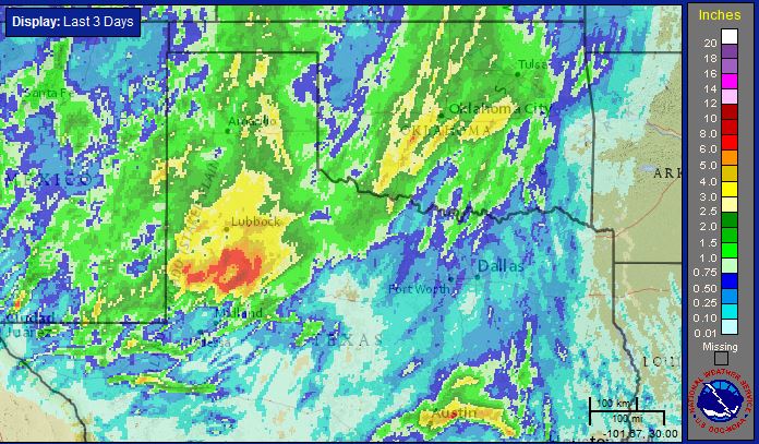 |
| Radar-estimated bias-corrected three day rainfall total ending at 5 pm on Wednesday, May 6th. Click on the image to see a zoomed in version over the South Plains region. |
| |
| The below images show some of the urban street flooding that occurred in Lubbock during and after the heavy rain. Lubbock officially recorded 4.64 inches over the two day stretch (May 4th-5th), with 3.42 inches falling on the 4th. This set a daily rainfall record, shattering the previous record of 0.82 inches that was set back in 2001. |
| |
|
|
| Pictures of flooding from around Lubbock on May 4th and 5th. From left to right: 20th and Avenue V (courtesy of Brock Burghardt); near Texas Tech University (courtesy of Emily Brown); and at Mae Simmons (courtesy of Juanita Dominguez and KCBD). |
| |
| Although the heavy rain did result in flooding, it also saturated soils in time for the upcoming growing season. In addition, the runoff dumped into area reservoirs. Lake Alan Henry in particular was a big winner; rising over 10 feet and jumping from around 74 percent full to completely full in the course of a day. |
| |
|
|
| Pictures of inundation flooding from around Lubbock (left and center) and Seagraves (right) on May 5th. From left to right: McCullough Park; Charles A Guy Park; and fun in the water at Seagraves (courtesy of Delia Benny Arriaga and KCBD). |
| |
| After a brief quiet period during the early afternoon of the 5th (Tuesday), another round of thunderstorms moved out of New Mexico and across the South Plains during the evening hours. This round of storms eventually strengthened and dropped hail, mostly small, over portions of Lubbock, though Wolfforth did observe golf ball sized hail. |
| |
 |
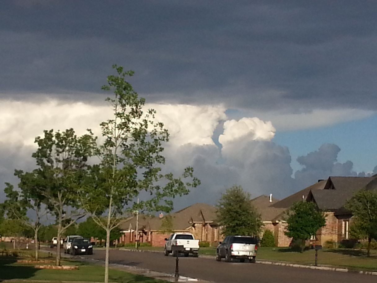 |
| (Left) Picture of hail falling in south Lubbock on the evening of Tuesday, May 5, 2015. (Right) Picture of storm clouds billowing to the east of Lubbock later that evening. |
| |
| Storms on the southern flank of the line further strengthened and one even produced a couple of brief tornadoes south of Ralls in Crosby County. Thankfully, these tornadoes occurred over open land and did no known damage before dissipating. |
| |
 |
| Tornado that formed about 7 miles south of Lorenzo during the evening of May 5, 2015. The image is courtesy of Kolin Duesterhaus. Click on the image for a larger version. |
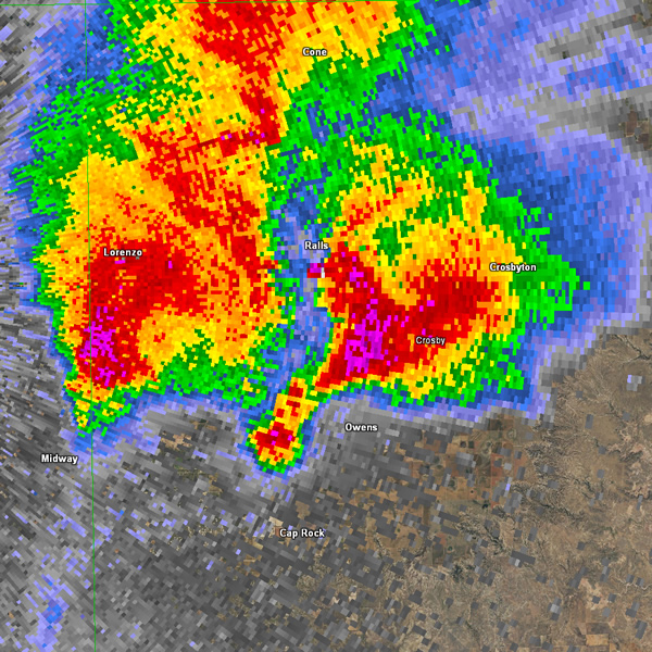 |
| Lubbock WSR-88D reflectivity image around 7:30 pm CDT on Tuesday, May 5th, 2015, showing the severe thunderstorm that produced two brief tornadoes in Crosby County. Click on the image for a larger version. |
| |
| The storms continued eastward, producing brief heavy rains and hail as large as baseball size south of Crosbyton, though no additional tornadoes were observed. |
| |
 |
| Regional radar animation valid from 6:58 to 8:08 pm on Tuesday, May 5, 2015. |
| |
| Another round of thunderstorms then developed the next evening, on Wednesday, May 6th, 2015, over the Rolling Plains. This activity was tamer, but still likely produced pockets of small hail, gusty winds and brief heavy rain as they moved eastward. The storms did provide a beautiful view when they were lighted by the setting sun. More severe weather, including a number of tornadoes, did occur from western North Texas into Oklahoma, Kansas and Nebraska on the 6th. |
| |
 |
| View of storms to the southeast of Lubbock during the evening of Wednesday, May 6, 2015. |
| |
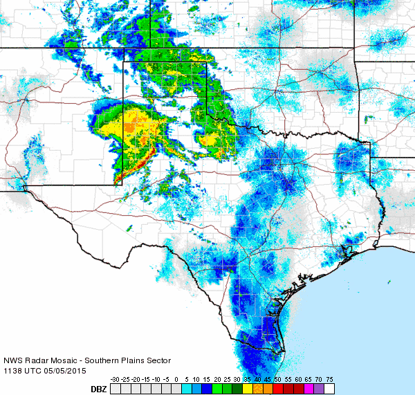
| As the western storm system reloaded, the active weather continued across West Texas through the late week and early into the weekend. One relatively weak upper level disturbance was enough, when coupled with a very moist atmosphere, to generate another round of strong thunderstorms and very heavy rain. This activity first developed as isolated thunderstorms early Thursday morning (May 7th), but quickly expanded into a slow moving complex that tracked across the southern Texas Panhandle, northern South Plains and northern Rolling Plains where it dropped very heavy rain. Rain totals of 1.50 to over 3 inches were common from Plainview through Tulia, Floydada, Turkey and Childress. This heavy rain created flooding in spots, including on I-27 in Hale Center and US Highway 87/86 in Tulia. |
| |
 |
| Regional radar animation valid from 8:58 to 10:08 am on Thursday, May 7, 2015. See an additional animation valid from: 2:28 to 3:38 pm Thursday, May 7, 2015. |
| |
| The showers and thunderstorms gradually diminished and shifted east on Thursday evening, but yet another round of storm then developed early Friday (May 8th), with the activity continuing through the day. The amount of moisture, instability, and wind energy even prompted a rare early day tornado watch which covered the region through much of the morning and afternoon hours. Golf ball size hail was reported around 10 am near Whitharral and Cotton Center, and Plainview and Floydada both saw similar size hail shortly before 11 am. The storms grew even stronger by afternoon, dropping hail as large as tennis balls east of Childress shortly after noon. |
| |
|
|
| A few different pictures from around Slaton after the storms: (left) awning damage to Arranda Mexican Restaurant, courtesy of Dorthy Simental and KCBD; (center) broken vehicle windows in the United parking lot, courtesy of Chris Boger and KCBD; and (right) large hail that fell in Slaton, courtesy of Rebecca Chapa and KCBD. |
| |
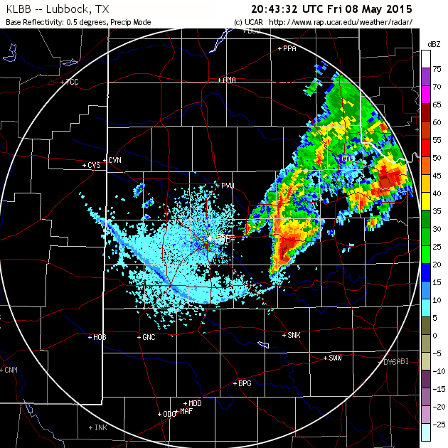
|
One particularly intense storm dropped large hail as large as softballs west of Slaton around 2:30 pm, and then continued east across Spur and then south of Guthrie through the late afternoon hours. Radar indicated strong rotation with the storm which prompted the issuance of a tornado warning as it moved over Spur (see the below radar imagery), but thankfully no tornado touched down out of the rapidly rotation wall cloud that was observed by spotters. Even though no tornado occurred, the storm did continue to produce very large hail and pockets of intense downburst winds. A wind gust to 70 mph was recorded by the West Texas Mesonet site 6 miles northwest of White River Lake. In addition, the strong winds did considerable damage to buildings and vehicles as they swept across Slaton.
Following are the Preliminary Local Storm reports for the South Plains region over the active early May stretch: May 4th; May 5th; and May 7-9th, 2015.
|
| |
|
|
| Lubbock WSR-88D reflectivity (left) and velocity (right) at 3:43 pm on Friday, May 8, 2015. This was around the time an intense supercell thunderstorm approached Spur. The storm produced a rapidly rotating wall cloud, but thankfully no tornado formed. |
|
The Supercell thunderstorm which developed across Crosby County continued to move east-southeast across the Rolling Plains. The storm then continued on across north Texas while remaining roughly between U.S. 82 on the north and U.S. 380 on the south. This storm produced a tornado just north of Throckmorton late Friday evening.
|
|
|
| This image shows the radar-estimated rotation and hail size on Friday, May 7th. It is used to track a storm's path. Click on the image to view a larger version. |
| |
| The repeated rounds of widespread heavy rain did create some flooding problems, but it also provided much needed runoff that allowed many normally dry washes and rivers to swell. The water poured out of the rivers and into local reservoirs, causing significant rises to occur. |
| |
|
|
| The widespread heavy rains caused high flows through many of the area rivers. (Left) The Brazos River 10 miles south of Aspermont (courtesy of John Lipe); (center) the White River at Silver Falls east of Crosbyton; and (right) the White River north of Cone (courtesy of Bruce Haynie). All pictures were taken on May 8, 2015. |
| |
| Below you can see the significant rises that occurred in the area lakes/reservoirs over early May. Lake Alan Henry filled up (the top of the dam is at 2220 feet), while Mackenzie Reservoir rose from 7% to 10% of capacity, and White River Lake jumped from 5% to 19% full. |
| |
|
|
| Change in lake/reservoir levels from May 2nd through May 12th, 2015. From left to right are: Lake Alan Henry; Mackenzie Reservoir; and White River Lake. |
| |
| One final round of showers and thunderstorms moved across West Texas Saturday morning as the primary upper level storm system lifted out into the central High Plains. This activity was more isolated, though a few storms did become strong and drop locally heavy rain before shifting off to the east during the afternoon. |
| |
|
|
| Bias-adjusted radar-estimated 7 day rainfall totals ending at 8 am on Monday, May 11, 2015. The left image is a regional perspective while the right image is zoomed in on the South Plains region. |
| |
| As the above images show, the early May heavy rains were widespread from West Texas into much of Oklahoma and North Texas. Weekly rain totals of 2.50 to over 6 inches were common. Childress officially tallied 6.00 inches over a 6 day stretch and boosted their annual rainfall to 12.39 inches, nearly doubling the average annual total for early May. Lubbock officially recorded 4.86 inches in early May. This raised the annual precipitation at Lubbock to 8.67 inches, which is also nearly twice the amount of average. |
| |
|
|
| The early May rains helped boost annual precipitation totals well above average for much of the region. The left plot shows the year-to-date departure from normal precipitation, and the right plot shows the year-to-date percent of normal precipitation. Both images are valid through May 11, 2015. |
| |
|
The above maps show the distribution of precipitation so far this year, though May 11th. Much of the region is now 2 to 6+ inches above normal for the year, which equates to 150% to 200+% of average. The one exception is in a small area from near Guthrie to Crowell, where yearly totals are close to average.
|
| |


