 |
 |
| Photograph taken at 7:50 pm of the supercell which produced a brief tornado west of Floydada. Photo courtesy Bruce Haynie. Click on the image to view a larger version. |
| |
| On Wednesday, April 22nd, a slow-moving cold front across the southern Texas Panhandle, an outflow boundary from overnight thunderstorms, and a dryline moving into the western South Plains, all combined to bring favorable conditions for severe weather across parts of the South Plains region. By mid-afternoon, isolated thunderstorms developed across the far southwestern Texas Panhandle in Deaf Smith County, where the boundaries coincided. One storm became dominant and produced large hail, severe winds gusts and a possible brief tornado near Hereford. The storm then tracked southeast across Swisher and Briscoe Counties and continued to produced large hail and strong straight-line wind gusts along its path. Tennis to baseball size hail was reported as the storm moved over Happy, TX, and a wind gust to 67 mph was observed by the West Texas Mesonet site just east of Tulia. |
| |
 |
| Radar animation from Lubbock WSR-88D valid from about 4:30 pm to 9:30 pm on Wednesday, April 22nd. Loop is courtesy College of DuPage (https://www.cod.edu). Click on the loop to view the full-size version. |
| |
| The storm eventually grew into a small storm complex which went across the northern Rolling Plains Wednesday night. In addition, another thunderstorm developed west of Plainview. This storm, although smaller than the first, was also a rotating supercell thunderstorm. This storm produced a brief tornado to the northwest of Floydada while also dropping large hail at times. The below images show a couple of different views of the severe thunderstorms Wednesday evening. The storms were very tall and could easily be seen from Lubbock as they rolled over Floyd County. In addition to the intense thunderstorms in northwest Texas, other strong and severe storms also affected central parts of the state at the same time, as can be seen in the below visible satellite image. |
|
|
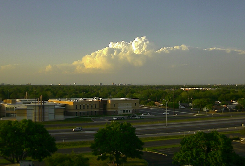
| (Left) View of the storm over Floyd County, as seen from south Lubbock, at 7:49 pm on April 22, 2015. (Right) View from space of several areas of thunderstorms scattered across Texas at 7:15 pm on April 22nd. Click on the images to view the full-size version. |
| |
| A couple of different views of the briefly tornadic storm near Lockney can be seen below. Thankfully, the tornado, which may have touched down briefly twice, occurred over open land and didn't do any damage. |
| |
|
|
| Two images captured by Roger Hill near Lockney, TX, Wednesday evening. The left picture shows the amazing structure of the supercell storm while the right picture shows a brief tornado touchdown. Click on each image to view a larger version. |
| |
| In addition to the severe weather, the storms dropped a swath of very heavy rainfall as they moved southeast. Spots from near Happy through Turkey and Paducah recorded a quick 1-2+ inches. Caprock Canyons State Park was particularly hard hit, when as much as 3.10 inches fell, causing a surge of water to flow down through the canyons. The overflowing stream compromised two of the park's road crossing, though only minor structural damage occurred (as can be seen below). |
| |
|
|
| Photographs of damage caused by flooding in Caprock Canyons State Park during the evening of April 22nd. The images are courtesy of Donald Beard. Click on the images to view a larger version. |
| |
| The thunderstorm activity finally shifted east of the area and weakened late Wednesday night. Below you can view the total rain and strongest winds recorded by the West Texas Mesonet sites on April 22nd. In addition, a plot of the radar-indicated mesocyclone tracks (a measure of the rotation within the storms) and a plot of the radar-estimated Maximum Estimated Size of Hail (MESH) can be viewed. A listing of the preliminary storm reports collected from the active evening of April 22nd can be VIEWED HERE. |
| |


