 |
 |
|
View looking west from the Overton Hotel on the afternoon of Sunday, April 28, 2014. The image is courtesy KAMC Lubbock.
|
| A powerful and slow-moving storm system moved out of the Rockies and into the Plains on the last weekend of April. After bringing isolated thunderstorms to the Rolling Plains on Saturday, April 26th, the storm's track brought very dry air into the region from the west. In addition, a strong pressure gradient surrounding the storm system resulted in gusty winds. Because the system was moving slowly, the winds lingered for several days. And, due to the ongoing drought, the winds lofted widespread blowing dust. The image below shows the general weather pattern which produced the winds and blowing dust across the region. |
 |
| The general weather pattern on Monday, April 28th. Because the upper-level storm system was moving very slowly, this pattern did not change much from April 27th to April 29th, and West Texas remained located beneath strong winds aloft. |
|
The first round of wind and blowing dust came on Sunday. Widespread severe wind gusts of 58 mph to 63 mph were reported by stations of the West Texas Mesonet, concentrated mainly from the southwest Texas Panhandle into the western South Plains. The image below shows how the wind and blowing dust spread across the area Sunday afternoon. |
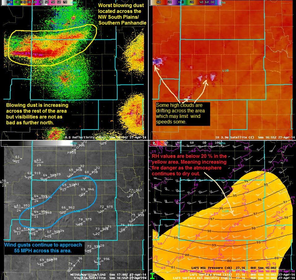 |
| A display of radar, satellite and surface analysis from Sunday, April 27th. |
| Not much changed in the weather situation on Monday, April 28th. Blowing dust once again developed as winds increased into the 30 to 40 mph range, with gusts to near 60 mph. In fact, the West Texas Mesonet station near Amherst reported a 66 mph wind gust. Some utilities poles and power lines were blown down in Lubbock and a semi-truck with an empty trailer was blown over near the town of Wilson, in Lynn County. The image below shows what the plume of blowing dust looked like via the Lubbock radar early Monday evening. |
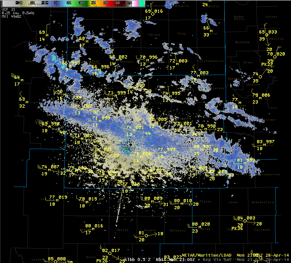 |
| A display of radar and surface observations from 6 pm CDT on Monday, April 28th. The large swath of radar returns running from Bailey County, through Lubbock County, and on into Haskell County is a blowing dust plume. |
| On Tuesday, as the upper-level storm system moved farther away from the region, the winds decreased somewhat. However, a cold front quickly moved south through the high plains, and the winds along it were strong enough to generate more blowing dust from eastern Colorado into the Texas Panhandle. Even though the winds were weaker across our area, the blowing dust moved in from the north, and quickly dropped visibilities to under a mile across much of the far southern Texas Panhandle and northern South Plains. Visibility of only a few blocks was reported for a time in the town of Tulia in Swisher County. The image below shows the cold front and the blowing dust moving into the northern portions of the South Plains late Tuesday morning. |
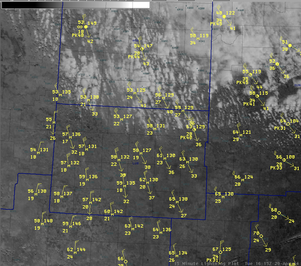 |
| Satellite and surface observations shortly after 11 am CDT on Tuesday, April 29th. The leading edge of the blowing dust can be seen across northeast Castro, Swisher, Briscoe and Hall Counties |
| The map below shows the maximum wind gust reports from the West Texas Mesonet (www.mesonet.ttu.edu) across the area for each day. |
|
|
|||
|
Toggle Maximum Wind Gust (mph) on April 27, 2014
|
Toggle Maximum Wind Gust (mph) on April 28, 2014
|
Toggle Maximum Wind Gust (mph) on April 29, 2014
|
|

