| More Wind and Dust for West Texas 3 April 2014 |
 |
| Picture of dust along the leading edge of a cold front as it was moving through Lubbock near sunset. The image was captured from the Overton Hotel, looking west at 8 pm. The picture is courtesy of KAMC. |
| Yet another strong upper level storm system tracked to the north of West Texas this spring, leaving the South Plains region on the windy and dry side. Strong westerly winds initially developed across the southwest Texas Panhandle and northwest South Plains around midday, then intensified further south while spreading eastward across the Caprock and into the Rolling Plains during the afternoon hours. |
 |
| Annotated visible satellite image captured at 5:10 pm on April 3rd. A large area of blowing dust is readily apparent over the eastern South Plains into the Rolling Plains and eastern Texas Panhandle. |
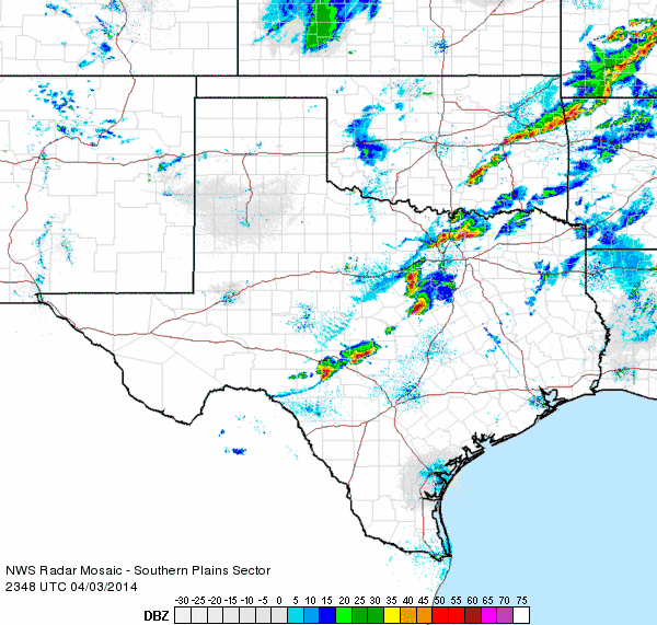
| Westerly winds sustained at 30 to 40 mph, with gusts to 45 to 55 mph, lofted blowing dust during the afternoon hours. The below radar image shows two distinct dust plumes that formed during the afternoon, one that stretched from Clovis to Amarillo, and another from near Hobbs to Lubbock. Visibilities of 1-3 miles were fairly common in the thicker plumes of dust, though localized near brownout conditions did occur. The blowing dust did contribute to at least one accident in the Amarillo area, before the dust shifted eastward during the late afternoon hours (as can be seen in the above image at 5:10 pm). |
 |
| Lubbock radar image created at 3:05 pm on 3 April 2014. |
| The strong winds and very dry conditions did also create a prolonged period of critical fire weather conditions, though fortunately no wildfires of consequence ignited across the South Plains. By evening, a stout cold front accelerated southward out of the Texas Panhandle and through the South and Rolling Plains, with gusty north winds in its wake. The radar animation below shows a faint fine-line indicating the leading edge of the cold front moving through the South Plains. Further east, where the wind energy interacted with much more plentiful Gulf moisture, scattered strong and severe storms developed from eastern Oklahoma into North and Central Texas. |
 |
| Radar animation valid from 6:48 to 7:58 pm on 3 April 2014. |
| The evening cold front did also produce a brief "wall" of dust as it moved southward across the Caprock, as can be seen in the below picture as well as the one at the top of the page. Thankfully, visibilities only dropped to or slightly below two miles for a short period as the front moved through before quickly improving. Winds then gradually settled down well behind the front late Thursday night. |
 |
| One more view of the cold front and "wall" of dust moving through Lubbock near sunset on April 3rd. This picture is looking west from Covenant Hospital. The image is courtesy of KAMC. |
 |
| The strong winds even caused some minor damage in Post. The above picture is courtesy of Kent Mahoney at the Post Dispatch. |
| The below map shows the maximum wind gusts, maximum sustained winds, and the high temperatures observed on 3 April 2014. The data are courtesy of the West Texas Mesonet. |
|
|
|||
|
Toggle Maximum Wind Gust (mph) on April 3, 2014
|
Toggle Maximum Sustained Wind Speed (mph) on April 3, 2014
|
Toggle High Temperatures for April 3, 2014
|
|

