|
Landspout Tornadoes Touchdown near the Lubbock Airport |
|||
|
|
|||
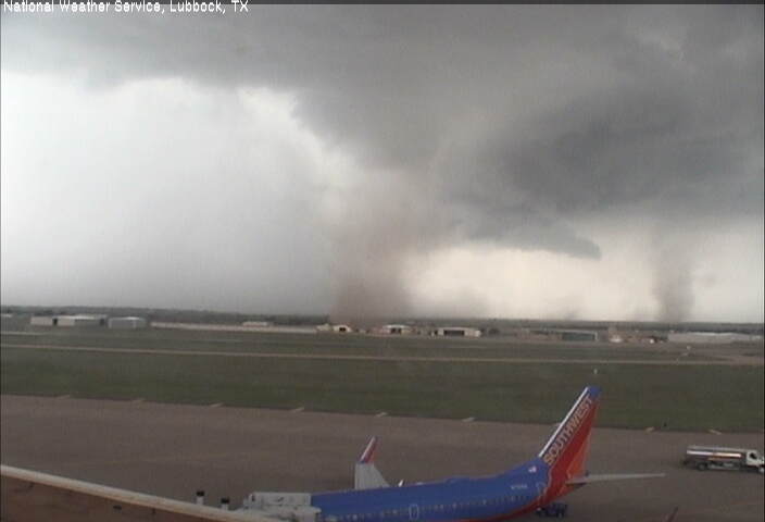
| Picture of two simultaneous landspout tornadoes just west of the Lubbock International Airport. The image was captured at 4:47 pm on Thursday, August 1, 2013. | |||
| Hot and humid conditions were enough to generate isolated to scattered afternoon thunderstorms across the South Plains on Thursday, August 1, 2013. These storms moved slowly and dropped locally heavy rain, gusty winds and even a little small hail in spots. In addition, one developing thunderstorm produced two brief landspout type tornadoes near the Lubbock International Airport. Unlike most tornadoes which form beneath a rotating (supercell) thunderstorm, landspout tornadoes form when an area of preexisting rotation near the ground becomes positioned beneath a rapidly developing thunderstorm cloud. The quickly rising air lifting into the cloud stretches the area of rotation near ground level vertically, resulting in an intensification of the spin and the formation of a landspout tornado. Normally landspout tornadoes don't last very long or get very strong, though they can do minor damage before dissipating. In this case, the tornadoes didn't cause any known damage. | |||
|
|||
| The above sequence of images initially (left) shows a rain foot, where descending rain and air hit the ground and spread out in all directions. The rain foot indicates a downdraft with strong outflow winds. A few minutes later (center) the first landspout tornado can be seen. A couple of minutes after that (right) the first landspout has weakened, but another landspout has formed to its right. | |||
|
|
|||
|
Lubbock radar reflectivity image valid at 4:43 pm on 1 August 2013. Click on the image for a larger version. |
|||
| The above and below radar images were captured around the time of the development of the first landspout tornado, just to the west (left) of the radar location (KLBB). A light blue fine-line can be seen draped from west to east near the radar. This fine-line indicates where two outflow boundaries, one from storms to the north and one from storms to the south, have collided. The colliding boundaries served as a focus for new thunderstorm development and also provided an area of spin in the lower levels of the atmosphere (as can be visualized by the adjacent red and green colors, or inbound and outbound velocities, in the image below just to the left of the KLBB), both which contributed to the development of the landspouts. Collectively, the tornadoes lasted around 10 minutes before diminishing. | |||
|
|
|||
| Lubbock radar velocity image valid at 4:43 pm on 1 August 2013. Click on the image for a larger version. |


