|
A Stormy Week in June |
 |
|
Picture taken Thursday evening (14 June 2012) in Lubbock by Mark Conder. Click on the image for a larger view. |
|
The middle of June has brought active weather, in the form of periods of showers and thunderstorms, to much of West Texas. These rounds of storms have come with some severe weather, but they have also brought welcome rain to the region. The below image shows that over the past week, most locations have received between 1 and 3 inches of welcome rainfall, with some isolated locations collecting almost 5 inches! The rainfall helped reduce the ongoing drought and brought some areas almost back to "normal" levels of rainfall. The Lubbock Airport was still running almost three inches low for the year as of June 18th, but had received almost a full amount for a typical June. Childress is now running about average for the year so far, and both Childress and Lubbock have received almost as much rain in less than 6 months than in the entire year 2011. |
|
|
| Seven day rainfall totals, as estimated (and bias corrected) from radar, ending early Sunday morning (17 June 2012). Click on the image to view a larger version. |
| The active weather kicked off in earnest during the evening and overnight hours of the Tuesday, the 12th. Initially, one left-moving (anti-cyclonically rotating) storm developed and moved northeastward across the southwestern and west-central South Plains (see the radar animation below). This storm was quite intense and produced very large hail, to baseball size, and one brief tornado near Whiteface. Thankfully, the tornado was short-lived and didn't do any damage. |
|
|
| Regional radar animation from 8:28 to 9:38 pm Tuesday evening (12 June 2012). |
|
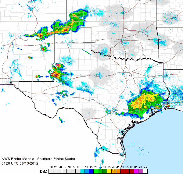
Later that same night, after the initial supercell storm that produced the severe weather across the western South Plains fell apart, a much larger complex of storms moved from the Texas Panhandle southeastward into the South Plains and Rolling Plains (see the radar animation below). This complex produced severe outflow winds at a number of places across the southern Texas Panhandle and northern South Plains, including a peak wind gust of 69 mph measured by the West Texas Mesonet site located 6 miles south of Olton. In addition, the area saw widespread rainfall, with locally heavy rain. Several spots, including Turkey, Memphis, and Childress, picked up over 2 inches of rain. For a complete listing of the preliminary storm reports for this day CLICK HERE. |
|
|
| Regional radar animation from 12:18 to 1:28 am Wednesday morning (13 June 2012). |
|
After a one day reprieve Wednesday afternoon and evening, Thursday evening (14 June 2012) brought another thunderstorm complex that tracked from northwest to southeast across the area and produced more severe wind gusts and widespread rainfall. In addition, strong outflow winds pushed out ahead of the storms and picked up copious amounts of dirt and dust, generating a haboob that tracked southward through the central and southern South Plains (see the image below). |
|
|
| Image of a haboob moving through Lubbock Thursday evening (14 June 2012). Picture is courtesy of Jason Jordan. Click on the image for a bigger view. |
|
|
|
The below radar image was captured as the leading edge of the outflow boundary (and haboob) was pushing through southern Cochran, Hockley, Lubbock and Garza Counties. The haboob briefly reduced the visibility to near zero in spots. However, locally heavy rains and a lot of small hail soon followed for some locations, including the southwest side of Lubbock. Later that night, one dissipating storm produced a strong heatburst across Childress County, which caused wind gusts of over 75 mph and a temporary jump of temperatures into the 90s between 2 and 3 am. To view the preliminary storm reports for this day CLICK HERE. A report constructed for this event from the West Texas Mesonet can also be FOUND HERE. |
|
|
| Radar image captured at 7:53 pm on Thursday evening (14 June 2012), with surface observations from 8 pm also plotted. Click on the image for a larger view. |
| A plot of the preliminary storm reports throughout the active stretch in mid-June can be found below. |
|
|
||
|
Preliminary storm reports from the event
|
||
|
Toggle Storm Reports from 6/12/2012
|
Toggle Storm Reports from 6/14/2012
|
Toggle Storm Reports from 6/15/2012
|
| On Friday the 15th, a thunderstorm complex formed in eastern New Mexico, and then swept eastwards across the South Plains through the evening hours, producing strong winds and creating another wall of blowing dust (see below). |
 |
| Regional radar animation from 9:38 to 10:48 pm Friday evening (15 June 2012). |
|
Heavy rain, visibilities less than a quarter-mile and up to dime-sized hail was also reported across southwest Lubbock Friday evening. The storms continued into the Rolling Plains during the early morning hours of Saturday the 16th. While the storms lost much of their punch after midnight, one dissipating storm produced winds in excess of 70 mph in Hart and Happy around 1 am Saturday. For a complete listing of the preliminary storm reports for Friday CLICK HERE. |
|
|
| Regional radar animation from 7:08 to 8:18 pm Saturday evening (16 June 2012). |
|
One final active weather day followed on Saturday, the 16th, as storms initially erupted in the Rolling Plains during the afternoon. Then, later that evening, several clusters of thunderstorms edged into the area from eastern New Mexico (see the above radar animation), bringing additional rains to many locations. The overall intensity of the storms on Saturday was lesser than previous days, with no reports of severe weather received. However, several spots did receive locally heavy rainfall. Quieter weather then returned to the South Plains just in time for Father's Day. |


