|
Cool and Wet Weather Visit the Region |
 |
| Picture of a funnel cloud captured northwest of Petersburg on 11 May 2012. The picture is courtesy of KCBD. |
|
May 2012 started out hot and generally dry, but the second week of May brought a protracted period of cooler and wetter conditions to West Texas. The cooler weather was initially ushered in by a cold front that moved through the area on Sunday, the 6th. This front didn't produce precipitation when it moved through, but it did start the cool-down, knocking highs from the 90s and triple digits back into the 60s and 70s. |
 |
| Regional radar animation captured from 9:18 pm to 10:28 pm CDT on Monday, 7 May 2012. Another radar animation valid from 11:38 pm on the 7th to 12:48 am CDT on the 8th can be FOUND HERE. |
|
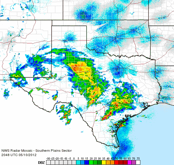
Precipitation first began to increase the next day (7 May 2012) as a couple of upper level jets worked together with increasing moisture to bring showers and thunderstorms to parts of the central and southern South Plains (see the above radar display). The southwest South Plains was the big winner this night, with a few spots from Denver City to Brownfield recording an inch or more of rain. The precipitation of the 7th tapered off by early on the 8th, but it stayed cool, with highs only in the 60s to lower 70s. The following day (Wednesday, 9 May) was also dry, but a bit warmer as plenty of sun greeted the area and temperatures climbed into the 70s and lower 80s. |
 |
| Regional radar animation captured from 11:38 am to 12:48 pm CDT on Thursday, 10 May 2012. Another radar animation valid from 3:48 pm to 4:58 pm CDT on the 10th can be VIEWED HERE. |
| The next round of rain moved in from the south on the Thursday (10 May) as a slow moving upper level storm system approached from the west (see the above radar depiction). Southern portions of the South Plains and Rolling Plains faired the best, with many spots recording an inch or more of rain, though most places received at least a little rain. The clouds and rain kept temperatures cool, mostly in the 60s. The upper level storm lingered in the area on Friday (11 May), but this time took aim further north, with the southeast Texas Panhandle under the gun and recording over an inch in many spots. The cool and damp conditions, combined with the lift from the passing upper level low, even resulted in several funnel clouds developing across parts of the South Plains (see the picture at the top of this article). Thankfully, these types of funnels rarely touch down, and when they do they are generally quite weak and short-lived. In this case, no known tornado touchdowns occurred. |
 |
| Regional radar animation captured from 8:28 pm to 9:38 pm CDT on Sunday, 13 May 2012. |
| Cool conditions continued into the weekend, with rain again increasing by Sunday (13 May) afternoon and evening as the next upper level storm system began to approach from the northwest (see the above radar loop). Showers and thunderstorms, most widespread and intense across the southwest Panhandle and northwestern South Plains, continued into Monday (14 May). The rain then quickly diminished, from north to south, Monday evening, as the upper level storm system shifted to the south of the area. |
|
|
| Observed rainfall totals for the beginning half of May (1st through the 14th). The data is courtesy of the West Texas Mesonet and that National Weather Service. Aside from a couple spots, all of the rain fell between the 7th and the 14th. Click on the plot for a larger view. |
| The official rainfall totals for Lubbock and Childress for the month (through the 14th) now stand at 1.27 inches and 0.70 inches, respectively. This rainfall does help put a dent in the ongoing drought, though continued rains will be needed to fully vanquish the drought. |
|
|
| 14-day total rainfall, as estimated from radar (and bias corrected), ending at 4 am on 15 May 2012. Most of the rain fell between the evening of the 7th and the evening of the 14th of May. Click on the image for a larger view. |
| All in all, May 7th through 14th provided beneficial rains (see the above map), without severe weather, and some welcome cooler weather. Many locations recorded an inch or two of rain, with some localized heavier amounts. In addition, temperatures through the period averaged about 10 degrees below normal. |


