|
|
||||||||
| Picture of Phil Hoel Park, in Lubbock, taken on 5 December 2011. Click on the image for a larger view. | ||||||||
|
Early December 2011 brought a return to winter for the South Plains region. Initially, a cold front moved through on Thursday, 1 December 2011, dropping temperatures down to around or just below the freezing mark. The cold, cloudy, foggy and damp conditions ushered in by the cold front persisted through the day Friday, the 2nd. Although precipitation was light, generally limited to areas of drizzle and freezing drizzle, it did create some hazardous travel conditions. Unfortunately, the slick conditions even contributed to a fatal pickup crash south of Hale Center on I-27 during the morning of the 2nd. More widespread and intense precipitation fell, generally in the form of showers and thunderstorms, early Saturday morning (3 December 2011) as an upper level disturbance raced by. Much of the region received a quick quarter to half an inch of rain, though amounts varied. Thankfully, temperatures held steady and even warmed slowly early Saturday, which help to minimize impacts. However, Friona did receive 0.4" of snow. Temperatures warmed further, with widespread 40s and 50s by Saturday afternoon. However, the next shot of cooler air then moved in Sunday (4 December), with a reinforcing shot of cold air Monday (5 December). |
||||||||
|
|
||||||||
| Observed snowfall totals, as reported to the National Weather Service (NWS), for 4-5 December 2011. The data is courtesy of the NWS Cooperative Observers, valid the morning of the 5th. Click on the map for a bigger view. | ||||||||
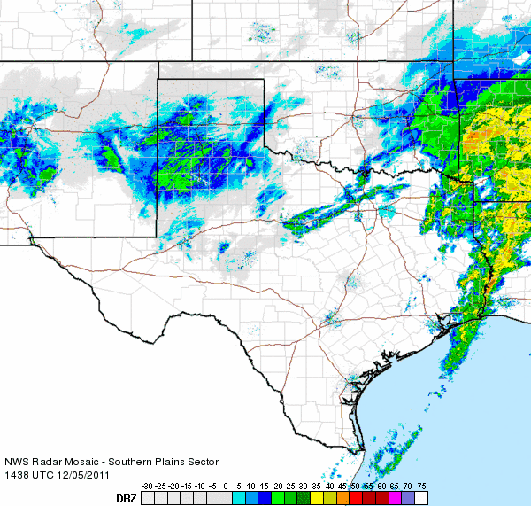
| In addition to the cooler air moving back in on Sunday, a potent upper level trough began to approach the area. This led to widespread light to moderate precipitation expanding across the area Sunday night. Some locations did experience periods of rain and sleet Sunday evening, but the dominate mode quickly became snow, with a trace to several inches of snow falling across most of the region by Monday morning (see the above map). The below radar animation shows widespread snow falling across much of the South Plains and southern Texas Panhandle Monday morning. Periods of snow and flurries continued through much of the day Monday, with additional accumulations of a trace to a couple inches common, before the snow came to an end Monday night. | ||||||||
|
|
||||||||
| Southern Plains radar loop from 8:38 am to 9:48 am CST on 5 December 2011. Additional radar loops beginning from: 10:18 - 11:28 am and 1:28 - 2:38 pm on the 5th are also available by clicking on the desired time window. | ||||||||
| The below satellite images show what the storm system looked like from space while light to moderate snow was falling across much of the region Monday morning. Widespread cloud cover enveloped much of Texas, with the strongest lift and tallest clouds confined to New Mexico and the western Panhandles at the time of the images. | ||||||||
|
||||||||
|
|
||||||||
|
Visible satellite image captured around 1 pm CST on 6 December 2011. Click on the picture for a bigger view. |
||||||||
| In addition to the snow, frigid air spread southward over the region, with clearing skies providing the coldest night of the season Monday night. Temperatures by early Tuesday morning were in the single digits and teens for most of the area (reference the map below). The West Texas Mesonet site at Friona recorded a teeth-chattering low temperature of -4°F. The official low at Lubbock was 9°F. Although very cold, this was still shy of the record of 1°F, set in 1950. However, this was the coldest air since early February of this year. | ||||||||
|
|
||||||||
| Low temperatures observed on the morning of 6 December 2011. Data is courtesy of the Texas Tech West Texas Mesonet. Click on the map for a larger view. | ||||||||
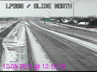
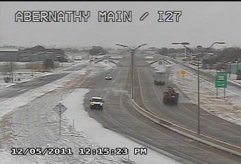
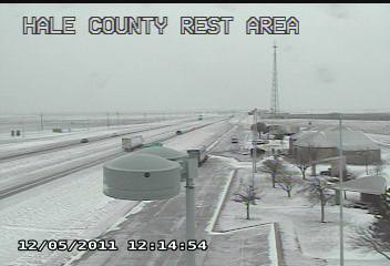
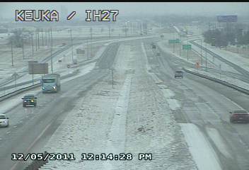
| The snow and cold weather did create some travel problems, and areas of snow and ice developed on roadways. Below are several pictures of roads in and around Lubbock around midday on Monday. | ||||||||
|
||||||||
| Below are more pictures captured from around Lubbock on Monday. | ||||||||
|
|
||||||||
| Picture of Huneke Park, in Lubbock, taken on 5 December 2011. Click on the image for a larger view. | ||||||||
| The snow made for pretty pictures, but the wind produced a cutting chill. Even some of the waterfowl were wondering why they made the long trip south only to be greeted by bitter cold weather. | ||||||||
|
||||||||
| Below is a series of visible satellite images taken each morning from the 4th through the 6th of December (Sunday-Tuesday). Note that on the 4th, skies were partly cloudy and no snow was in place on the South Plains. By Monday, clouds (and areas of snow) had spread over the region as the storm system approached from the west. On Tuesday, skies cleared from west-to-east revealing a large shield of snow across New Mexico and much of West Texas. | ||||||||
|
||||||||


