|
Storms Strike the South Plains Region 16 September 2010 |
|||
|
|
|||
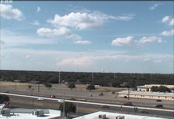
| View of storms developing during the afternoon hours on 16 September 2010. The picture is taken from Lubbock looking northwest around 4:30 pm. Click on the picture for a larger view. | |||
|
A hot and moist mid-September day set the stage for an active afternoon and evening of thunderstorms across much of the southern Texas Panhandle, South Plains and Rolling Plains. Highs on Thursday, September 16th, topped out in the lower and middle 90s, about 10 degrees above average, and when coupled with plenty of low-level moisture, it provided more than sufficient fuel for storms. The trigger for the thunderstorms came in the form of a weak passing upper level disturbance and several low level boundaries including an outflow boundary and a residual cold front. |
|||
|
|
|
||
| Lubbock radar reflectivity image captured at 5:20 pm (left) and 6:16 pm (right) on 16 September 2010. Click on the images for a larger view. | |||
| The thunderstorms initially developed in the Texas Panhandle and the Rolling Plains. The most intense storm of the day developed and moved across the southwest part of Amarillo before translating southeast and eventually weakening across Briscoe County. Before weakening, the storm generated very heavy rain, strong winds and large hail that affected both Amarillo and Palo Duro Canyon. A report of 3.54" of rain was received from southwest Amarillo, which resulted in flash flooding. Additionally, up to golf ball sized hail fell in Amarillo, with 4" diameter hail (grapefruit sized!) observed at Palo Duro Canyon. | |||
|
|
|
||
| Lubbock radar reflectivity image captured at 8:11 pm (left) and 9:06 pm (right) on 16 September 2010. Click on the images for a larger view. | |||
|
The thunderstorms were not quite as intense as in the Texas Panhandle as they developed and moved southward across the South Plains and Rolling Plains. However, several of the storms were severe. One storm produced 1" diameter hail near Tell, TX. Strong outflow winds also downed power poles east and northeast of Tulia. The strong outflow winds that pushed out of the storms moved southwestward and became a focus for new development across the South and Rolling Plains. Although a few of the new storms became strong or briefly severe, heavy rain was the most common feature, with the southern South Plains and southern Rolling Plains receiving the most widespread heavy rain. |
|||
|
|
|
||
| Lubbock radar reflectivity image captured at 10:16 pm (left) on 16 September and at 12:57 am (right) on 17 September 2010. Click on the images for a larger view. | |||
|
Eventually, during the early morning hours of the 17th, the precipitation began to taper off. Still, several locations experienced strong wind gusts in association with the decaying activity and its strong pressure gradients. The Lubbock Airport even recorded a wind gust to 58 mph just before 2 am. To view a summary of the preliminary local storm reports (LSR) on this event CLICK HERE. |
|||
|
|
|||
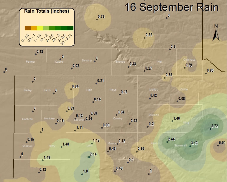
| Graphic displaying the observed 3-day rain totals through the evening on 17 September 2010. Most of the rainfall fell from the late afternoon of Thursday, the 16th, to early Friday, the 17th. The data is courtesy of the Texas Tech West Texas Mesonet and the National Weather Service. Click on the map for a larger view. | |||
|
The above map shows the distribution of observed rainfall that fell during the thunderstorm episode. Note that the swath of heavy rain from near Amarillo through Palo Duro Canyon and northern Briscoe and northwest Hall Counties is not captured by the observation network. Still, the graphic shows that most areas, aside from the northwest South Plains, saw some rain, while the heaviest (2"+) widespread precipitation was confined to southern sections. The heavy rain resulted in several locations that experienced flooded roadways. To view a story on this event composed by the Texas Tech West Texas Mesonet CLICK HERE. |
|||


