|
Several Active Late May & Early June Days |
||
 |
||
| Picture of a thunderstorm east of Silverton, taken from South Plains on the evening of 21 May 2010. The image is courtesy of Mark Conder. | ||
|
Late May and early June brought a few bouts of severe weather to the Texas South Plains region, not too uncommon for the late spring season. The active weather started somewhat slowly, with one severe thunderstorm that tracked from northwest Hale County into Swisher and Briscoe Counties during the late afternoon and evening hours of Friday the 21st of May. This storm produced large hail during its height before dying quickly after sunset. Reports of golf ball sized hail were received 5 miles east of Hart as well as 5 miles north of Silverton, though larger hail likely fell in a few rural locations. Above and below are a few pictures taken of the storm on the 21st. |
||
|
||
| A couple picutres of the thunderstorm that tracked across parts of the south-central Texas Panhandle on the evening of 21 May 2010. Click on the pictures for a larger view. The images are courtesy of Mark Conder. | ||
| The following weekend, the 22nd and 23rd of May, were rather uneventful locally, though severe storms did rake extreme northeast New Mexico on Sunday, even producing several tornadoes around the Clayton area. | ||
|
||
| Two snapshots of the Lubbock National Weather Service radar on the afternoon of 24 May 2010. The left image was taken at 4:16 pm, and shows several hail producing thunderstorms. The right image was captured at 5:22 pm, and displays an organizing storm that eventually produced a brief funnel cloud west of Paducah. Click on the images for a larger view. | ||
| The weather again became more active to begin the week, with scattered severe thunderstorms developing and moving across portions of the central and eastern South Plains and much of the Rolling Plains on the 24th. These storms brought more large hail to several locations, including golf ball sized hail 8 miles north of Lockney. One storm even generated a brief funnel cloud about 5 miles west of Paducah. Above are a couple of radar views of the storms on the afternoon of 24 May 2010. | ||
|
|
||
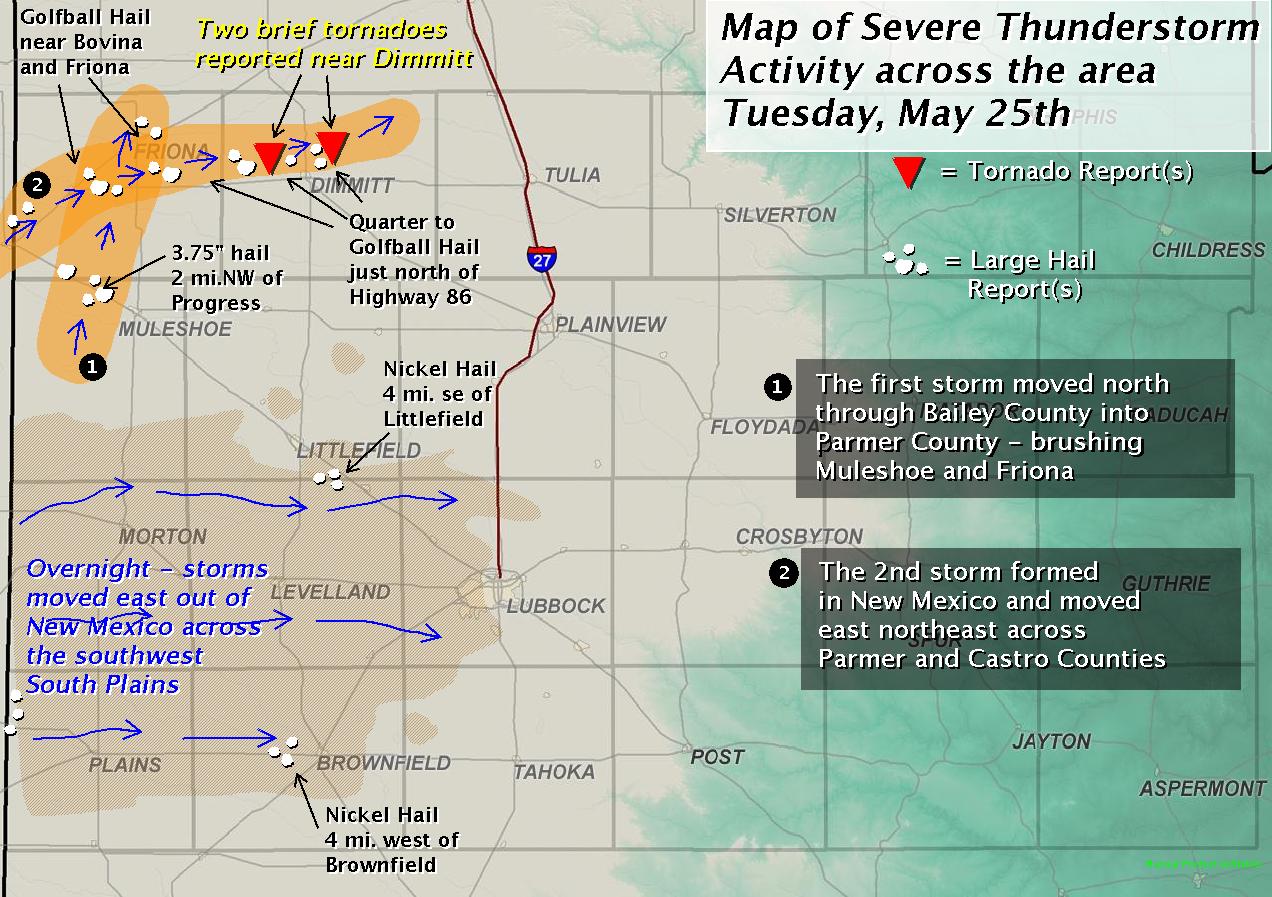
| Map of severe thunderstorm activity on 25 May 2010. Click on the image for a larger view. | ||
| The active weather shifted westward on Tuesday the 25th of May. The extreme northwest South Plains and southwest Texas Panhandle were under the gun as two separate supercell thunderstorm slowly traversed the area. The first storm produced a funnel cloud northwest of Friona and baseball to softball sized hail northwest of Progress. The second of the two storms dropped large hail too, but also produced a couple of very brief tornadoes near Dimmitt. No damage was reported with any of the tornado touchdowns. Eventually, storms in eastern New Mexico spread eastward into the South Plains with gusty winds and areas of hail late Tuesday night. | ||
|
|
||
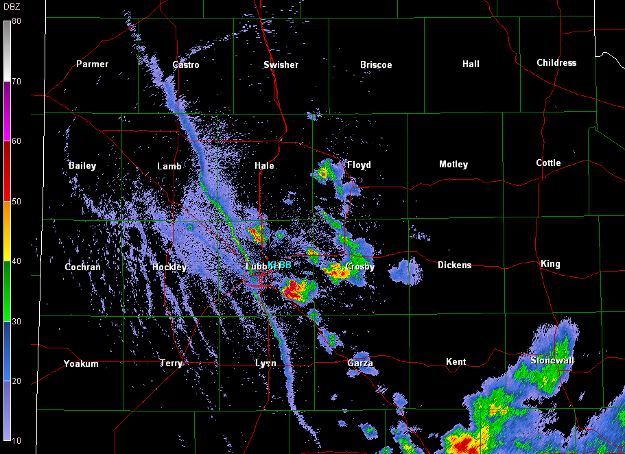
| A view of the Lubbock National Weather Service radar on 26 May 2010 at 6:50 pm. The strong outflow boundary which was moving westward can clearly be seen from western Castro County into eastern Lynn County. Additionally, the storm that produced heavy rain and hail at Ransom Canyon is seen in southeast Lubbock County. Click on the image for a larger view. | ||
|
The weather began to wind down by mid-week, but still gave one last hurrah on Wednesday the 26th of May. Though the wind shear had weakened from previous days, enough moisture and instability combined with a strong outflow boundary to create a number of pulse type storms that produced hail and locally heavy rain. The largest hail was reported at Ransom Canyon where nickel to quarter sized hail covered the ground. Additionally, a few isolated locations received a quick inch or two of rain. Relatively tranquil weather then visited the region to end the week and begin the weekend, but a brief ramp up returned late in the weekend and continued into the first half of week, moving into early June. Sunday, May 30th, brought rather benign scattered thunderstorms with light rain to parts of the South Plains. By Memorial Day the intensity of the storms increased, with several severe cores tracking across the South Plains. Wind gusts near 60 mph were measured near Olton and Plainview. Another round of severe weather struck the South Plains Tuesday, June 1st, with up to golf-ball sized hail observed in Abernathy. The Lubbock Airport also picked up just over an inch of liquid, though southern portions of the city saw much less. The severe weather spread across the southern South Plains and the Rolling Plains on the Wednesday, June 2nd. This round of severe weather brought golf-ball sized hail to Meadow and near Jayton. Additionally, a few locations picked up a quick one to three inches of rain. To view the preliminary storm reports for the active late May and early June weather, click on the date of interest below: |
||


