National Weather Service United States Department of Commerce
 
Wind, Dust and Fires - 4 April 2009
Map displaying maximum measured wind gusts across the region on 4 April 2009. Data is from the West Texas Mesonet, the National Weather Service and the KVII TV Schoolnet.
Map displaying maximum measured wind gusts across the region on 4 April 2009. Data is from the West Texas Mesonet, the National Weather Service and the KVII TV Schoolnet. Click on the image for a larger view.

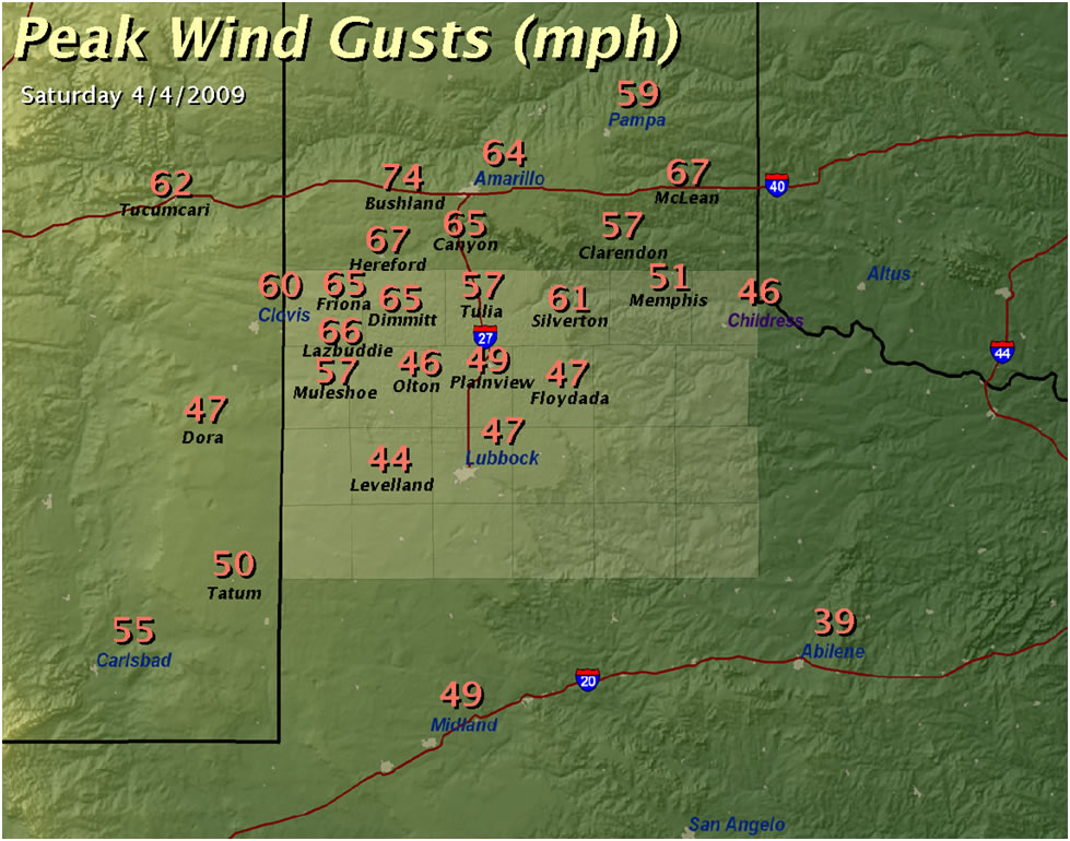
Severe winds generated a deadly dust storm and aided in the development of numerous wildfires over the Southern Plains on Saturday 4 April 2009. While damage reports have been limited on the west Texas South Plains, wind gusts up to 66 mph, blinding dust, and at least three wildfires impacted the local area.

Strong westerly winds began to blow over the South Plains late Saturday morning, as a potent upper air storm system progressed over Colorado and Kansas. The winds lofted vast amounts of dust which originated in fields along the Texas and New Mexico border near Clovis, and spread northeastward over the Panhandle. Near-zero visibilities were reported along U.S. Highway 60 in Parmer County. The blinding dust storm went on to contribute to numerous accidents along Interstate 40 near Amarillo, where media reports indicate up to ten injuries and one death in weather related accidents.

Map of known fires that occurred of 4 April 2009.
Map showing the locations of nearly twenty satellite detected wildfires across the Southern Plains Saturday afternoon (4 April 2009).


The weather pattern that generated the dust storm also drove an outbreak of wind-driven wildfires that developed from eastern New Mexico northeastward to southern Kansas. A massive fire reported to burn 12,000 acres in the eastern Texas Panhandle destroyed several homes and prompted the evacuation Wheeler. Three firefighters were treated for smoke inhalation. On the South Plains, large wildfires were reported in parts of Castro and Swisher Counties. Although no damage was reported there, a fire in Yoakum County threatened oil field equipment.

Satellite image displaying fires, dust and a strong storm system of 4 April 2009.
Southern Plains Wildfire Outbreak Composite map.
Saturday’s weather pattern matched a known composite for extreme fire weather episodes in the Southern Plains. Yellow-shaded circles in the satellite image (left) denote detected wildfire “hot-spots”. The right image displays the composite map pattern corresponding to wildfire outbreaks over the South Plains. Click on the images for larger views.
 

Saturday’s weather pattern was a chinook-type critical fire weather pattern, which has been associated some of the most intense wildfire outbreaks across the Southern Plains in recent years. The strong storm system that impacted the region was accompanied by intense lower and middle atmospheric winds, with 100 kt overspreading the Panhandle yesterday afternoon at an altitude of about 18,000 feet. These winds were partially transported toward the ground by subsiding air on the back side of the passing low pressure center. The strong downslope winds allowed relative humidities to plummet to between 5 and 15 percent as temperatures warmed to above seasonal levels. This, combined with the winds, provided for an environment that has been correlated to a “moderate” or “high” occurrence of wildfire evolution locally in west Texas.


Image of relative humidity (blue=dry air to orange=moist air) and wind Saturday afternoon.  The combination of relative humidity and wind over west Texas created an environment favorable for dangerous wind-driven wildfires. Click on the image for a larger view.
 
Image of relative humidity (blue=dry air to orange=moist air) and wind Saturday afternoon. The combination of relative humidity and wind over west Texas created an environment favorable for dangerous wind-driven wildfires.
 

A preliminary tally of storm reports for Saturday 4 April 2009 can be found by CLICKING HERE.