Strong Winds and Dust Impact the Region (12/14/2008)
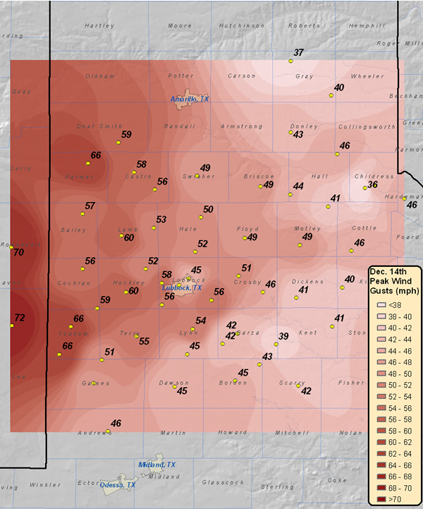
| Image of the highest wind gusts (mph) recorded across the region on December 14, 2008. The above image was created with data from the Texas Tech West Texas Mesonet, as well as from the National Weather Service. County names are also displayed. Please cick on the map to view a larger version. |
A tight surface pressure gradient combined with strong middle and upper level wind fields on the south side of an upper level storm system passing to the north of the region to bring stout winds to West Texas.
The day began rather mild, and abundant sunshine allowed temperatures to quickly warm through the 50s and 60s, with some locations topping out in the 70s. However, the warm temperatures came with a price, as the warmer air promoted deep vertical mixing of the atmosphere. The deep mixing in turn helped transport very strong winds aloft to the surface. These winds were strongest on the Caprock, where wind gusts between 50 and 66 mph were common from late in the morning through early in the afternoon. A peak wind gust of 72 mph was recorded by the Texas Tech West Texas Mesonet near Tatum, NM, with gusts to 66 mph observed near Plains, Friona and Denver City. As is typical, the strong winds also lofted plentiful amounts of dust into the air, with the visibility at the Lubbock airport briefly dropping to one mile around noon.
Thankfully, the strong winds began to diminish during the afternoon hours as a cold front dropped in from the north with much colder air in its wake. Temperatures dropped into the teens across the entire region by the following morning.
The following are peak wind gust reports from around the region. All reports are from the Texas Tech West Texas Mesonet unless noted: Tatum 72 Dora 70 Denver City 66 Friona 66 Plains 66 Amherst 60 Levelland 60 Hereford 59 Sundown 59 Dimmitt 58 Reese Ctr 58 Muleshoe 57 Hart 56 Morton 56 Slaton 56 Wolfforth 56 Brwnfield 55 Tahoka 54 Olton 53 Abernathy 52 Anton 52 Ralls 51 Seagraves 51 Lubbock 50 Plainview 50 Floydada 49 Roaring S 49 Seminole 49 Silverton 49 Tulia 49 Andrews 46 Goodlett 46 Memphis 46 Paducah 46 White Riv 46 Gail 45 Lamesa 45 O'Donnell 45 Lubbock 45 *NWS reporting station Childress 44 Turkery 44 Aspermont 43 Clarendon 43 Fluvanna 43 Graham 42 Post 42 Snyder 42 Jayton 41 Northfield 41 Spur 41 Guthrie 40 McLean 40 Lake Alan Henry 39 Pampa 37 Childress 36 *NWS reporting station

