National Weather Service United States Department of Commerce

Storms Bring Hail, Wind and Heavy Rain

27 May 2008

Picture of a storm as it bears down on Dickens on 27 May 2008. Picture by Gary Skwira.
Picture of a storm as it bears down on Dickens on 27 May 2008. Picture by Gary Skwira


Widespread showers and thunderstorms developed along a slow moving cold front during the afternoon hours of Tuesday, May 27, 2008. These showers and thunderstorms brought moderate to heavy rain to much of the central and southern South Plains and Rolling Plains, before finally shifting southward and diminishing during the overnight hours. Additionally, strong instability and modest wind shear allowed many of the storms to become strong to severe, with numerous reports of hail and high winds.
 

Graphic of bias corrected radar rainfall estimates from the afternoon and evening of 27 May 2008. Click on the image for a more detailed view of raw radar estimated precipitaiton from the Lubbock NWS radar.
Graphic of the bias corrected radar rainfall estimates from the afternoon and evening of 27 May 2008. Click on the image for a more detailed view of raw radar estimated precipitation from the Lubbock NWS radar.

Above is a radar estimate of the precipitation that fell between Tuesday and Wednesday morning (27-28 May). In many cases, the rain came quite fast, and this resulted in some localized flooding. Many locations received a quick inch or more, with the Spur and Lamesa Coop observers reporting 1.70 and 2.34 inches, respectively. In addition, the West Texas Mesonet sites near Aspermont and Lake Alan Henry measured 1.85 and 1.58 inches, respectively. Also, automated gages in southern Cottle and northern King counties collected between 1.50 and 2.00 inches. For a complete listing of 24-hr rainfall reports the morning after the event CLICK HERE.


Picture of a storm located west of Roaring Springs on 27 May 2008. The image was taken just west of Roaring Springs, looking westward. Click on the image for a larger view. Photo by Gary Skwira.
Picture of a storm as it approached Roaring Springs on 27 May 2008. Image was taken from Highway 70 a few miles south of Roaring Springs. Click on the image for a larger view. Photo by Gary Skwira.
Picture of a storm near Roaring Springs on 27 May 2008. Photo was taken by Gary Skwira while looking north from the Afton area. Click on the image for a larger view.
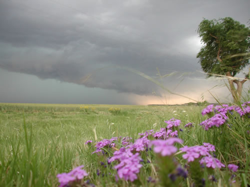
Series of pictures taken of a storm near Roaring Springs on 27 May 2008. Click on the images for a larger view. Photos taken by Gary Skwira.


The rain came with a price for some locations, with large hail and damaging winds. Above are some photographs of a storm that passed near Roaring Springs, bringing hail as large as golf balls in and around that area.

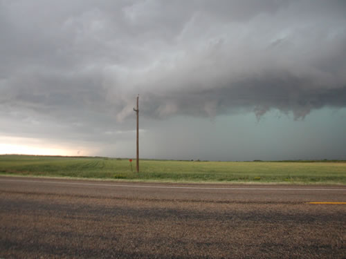
Numerous other locations were impacted by hail to one inch in diameter, as well as wind gusts estimated to around 60 mph. These strong winds and hail did cause some damage, including knocking a tree down onto a house in north Lubbock, blowing over 6 to 8 irrigation pivots near Hale Center, as well as destroying some young cotton field around the area. For a complete listing of the preliminary storm reports CLICK HERE.

Below are some pictures of another storm, initially near Crosbyton, then as it advances east and eventually affects Dickens. This storm brought 1.50 diameter hail to Crosbyton, and torrential rain, small hail and strong winds to Dickens.
 

Picture of a storm near Crosbyton on 27 May 2008. Photo was taken by Gary Skwira looking westward from Highway 62 east of Crosbyton. Click on the image for a larger view.
Picture of a storm near Crosbyton on 27 May 2008. Photo was taken by Gary Skwira looking southwestward from Highway 62 east of Crosbyton. Click on the image for a larger view.
Picture of a storm near Crosbyton on 27 May 2008. Photo was taken by Gary Skwira looking westward from Highway 62 east of Crosbyton. Click on the image for a larger view.
Picture of a storm as it approached Dickens on 27 May 2008. Photo was taken by Gary Skwira looking west-northwestward from just south of Dickens. Click on the image for a larger view.
Picture of a storm as it approached Dickens on 27 May 2008. Photo was taken by Gary Skwira looking west-southwestward from just south of Dickens. Click on the image for a larger view.
Riding out the storm in Dickens on 27 May 2008. Click on the image for a larger view. Photo by Gary Skwira.
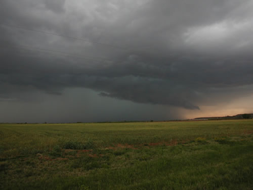
Series of pictures taken of a storm as it approached Dickens on 27 May 2008. The final image is of the storm as it was affecting Dickens. Click on the picture for a larger view. Photos by Gary Skwira.