National Weather Service United States Department of Commerce
Wind and Dust Slam Portions of the Area
 
Image of Dust associated with thunderstorms over the northwest South Plains the evening of 25 May 2008.
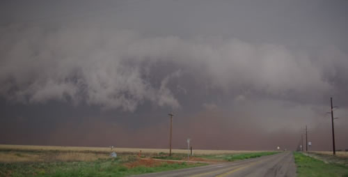
Image of dust associated with thunderstorms over the northwest South Plains the evening of 25 May 2008. Picture by Mark Conder.


During the late afternoon and early evening hours of Sunday, May 25, 2008, showers and thunderstorms brought widespread strong winds and a dense wall of dust to a large portion of the western and central South Plains and southwest and south-central Texas Panhandle.
 

Map of the storm total precipitation from early Sunday morning to early Monday morning (25-26 May 2008). Click on the map for a larger view.

The storms initially developed in close proximity to the dryline across southeast New Mexico. One particularly intense cell moved north-northeast through parts of Lea County, NM, before cutting northeast roughly along a Bledsoe to Enochs to Muleshoe to Dimmitt Line. In addition to strong winds, this particular severe thunderstorm produced a swatch of large hail. Golf-ball sized hail was reported 7 miles north of Muleshoe, with similarly sized hail also observed 14 miles west-southwest of Needmore. Above is a map of radar estimated precipitation for a 24-hour period encompassing this severe weather event. The swatch of heavy rain and hail in quite apparent (greens and purples) over the left portion of the image.
 
Picture of storm and wall of dust near Sudan on 25 May 2008. Click on image for a larger view. Picture by Mark Conder. Image of downed power poles take near Littlefield on 25 May 2008. Click on the image for a larger view. Picture by Mark Conder.
Picture of a storm and wall of dust near Sudan on 25 May 2008 (left), with post storm power pole damage near Littlefield (right). Click on images for a larger view. Pictures by Mark Conder.


However, the biggest story was the strong winds the most intense storm, along with other "less impressive" looking storms (from a radar and precipitation perspective) south of the strongest storm produced. Although most areas south of the strongest storm received little or no rainfall, numerous Texas Tech West Texas Mesonet sites did record wind gusts in the 60 to 80 mph range. A 79 mph gust was recorded 8 miles west-southwest of Sundown, with a 78 mph gust observed 7 miles west-northwest of Denver City.
 

Damage to a city shed in Muleshoe Texas on 25 May 2008. Click on the image for a larger view. Photo taken by Jack Rennels. Damage to a city shed in Muleshoe Texas on 25 May 2008. Click on the image for a larger view. Photo taken by Jack Rennels.
Damage to a city shed in Muleshoe Texas on 25 May 2008. Click on the image for a larger view. Photo taken by Jack Rennels. Damage to a building in Muleshoe Texas on 25 May 2008. Click on the image for a larger view. Photo taken by Jack Rennels.
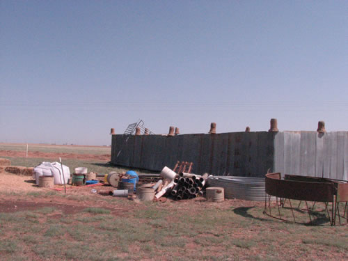
Damage to a city shed and buildings in Muleshoe Texas on 25 May 2008. Click on the images for a larger view. Photos taken by Jack Rennels.


The strong winds were accompanied by a wall of dust that temporarily dropped visibility to near zero. In addition to many power lines knocked down across parts of the area, some more extensive damage occurred near Muleshoe, where a one mobile homes was destroyed and another damaged. Also, a city shed was damaged, trees were knocked down, and some out buildings were damaged or destroyed. Above and below are some pictures of damage from the Muleshoe area.

Also, for a complete listing of the preliminary storm reports CLICK HERE.

To view a summary of the severe weather event composed by the Texas Tech West Texas Mesonet CLICK HERE.


Image of damage around the Muleshoe area from storms on 25 May 2008. Click on the picture for a larger view. Photo by Jody James.
Damage from in and around the city of Muleshoe. Click on the picture for a larger view. Photos by Jody James.