|
Olton-Edmonson Tornado Damage Survey Findings  |
|||||||||
|
Tornado northwest of Edmonson. (photo by Devon Phelps, courtesy KCBD-TV).
|
|||||||||
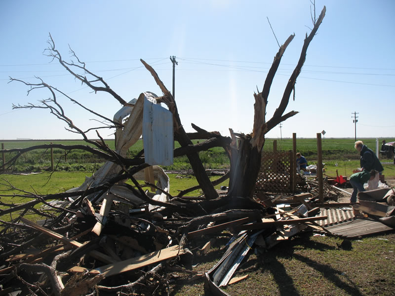
Tornado #2: Olton - Edmonson tornado Rated: EF-2 (max winds 111-120 mph) Path length: 24 miles Max width: 1230 yards (7/10 of a mile) Tornado began at 6:57 p.m. and ended at 7:36 p.m. with zero fatalities/1 injury. The tornado originated 5 miles south-southwest of Olton and moved northeast crossing northwest Hale county...southeast Castro county and far southwest Swisher county before dissipating about 10 miles northwest of Edmonson. The first visible damage included five medium voltage power poles downed just east of the intersection of FM168 and CR162. Just east of this location...the tops of five power poles were blown off to the north and two center pivots were overturned...one laying east to west and another southwest to northeast. Farther to the northeast along the tornado path...along CR152 east of FM168...two power poles were sheared off and a multi-story house suffered roof damage with a small portion of the roof ripped off on the southeast side. Skirting was pulled off a mobile home across the street from the house. Other minor damages were observed to out-buildings near the residence. This damage was consistent with wind speeds of 85 to 95 mph. Evidence was observed that the tornado remained on the ground until crossing U.S. Highway 70 east of Olton...including several center pivot irrigation systems overturned with multiple power poles snapped or sheared off within 3 to 5 feet of the ground. This damage was observed approximately 1.5 miles east of FM168 along CR321. The widest path of the tornado was also observed to be 7/10 of a mile along CR321. The damage was consistent with wind speeds of 95 to 105 mph.
The tornado crossed U.S. Highway 70 beginning about 2 miles east of Olton. Three homes were damaged along the highway suffering mostly roof damage. The third home sustained the most damage to the roof with a large evergreen tree laying west to east on the home. Tin was also peeled off a shed and blown to the north. About 1/10 of a mile east of these residences...a fourth and final home was severely damaged. The roof of this residence was completely torn off...a large metal structure housing farm equipment and vehicles was destroyed with metal beams twisted. Debris was scattered about 1/4 mile north into a field. One injury was sustained in the home during the tornado...as a resident took shelter under a kitchen table. The tornado path length along U.S. Highway 70 was estimated to be 4/10 of a mile ending near the Hale county line. The damage was consistent with wind speeds of 110 to 120 mph. The tornado continued northeast across mostly rural farm land. A storage barn sustained minor damage to the roof and three center pivots were overturned about one mile north of U.S. Highway 70 along CR80. Also along this road...several power poles were sheared off at the ground for approximately 4/10 of a mile. The damage was consistent with wind speeds of 90 to 100 mph. The tornado continued on a track to the northeast however little to no damage was observed by the survey team. |
|||||||||


