Rain Falls Across the Region (August 13-22, 2006)
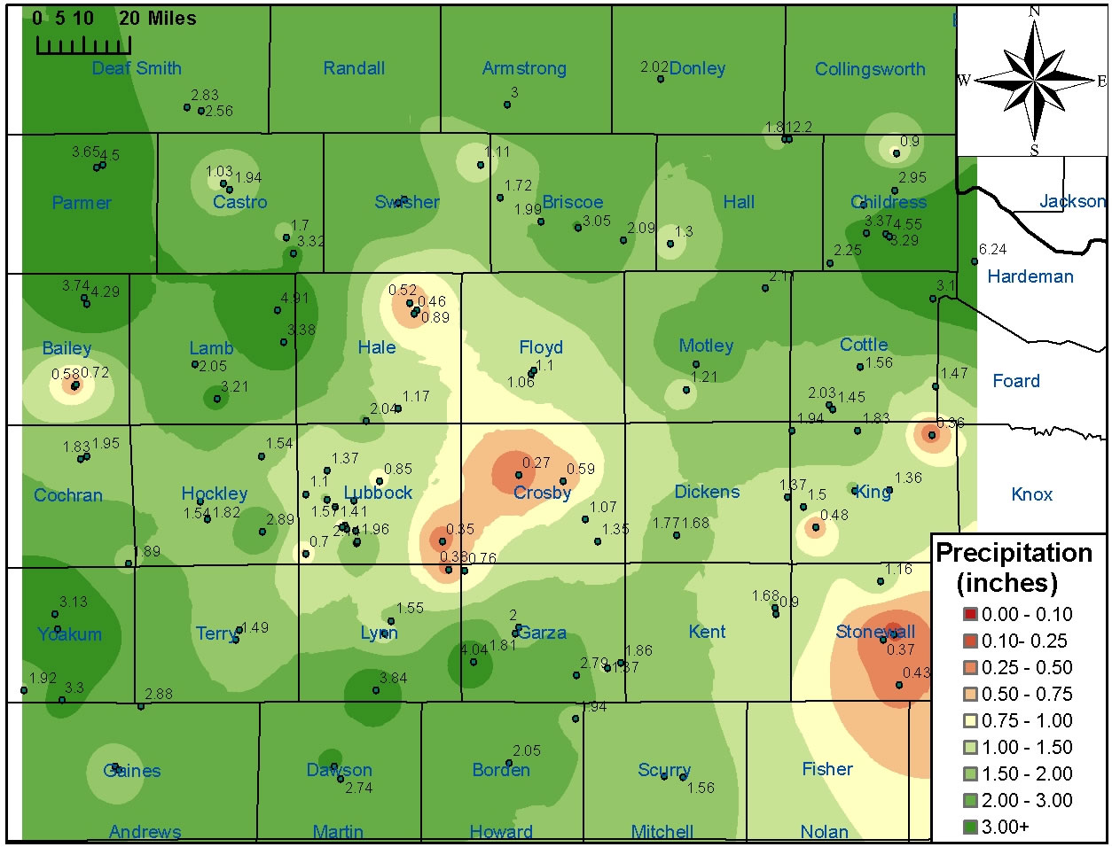
Above is a map of the rainfall (in inches) that fell across the region between 7 am Sunday, August 13, 2006 and 7 am Tuesday, August 22, 2006. The image was created from data gathered by West Texas Mesonet Stations, NWS Cooperative observation stations, and official NWS observing sites.
The highest rainfall total in the area was recorded by the West Texas Mesonet Station located 3 miles west of Goodlet, with 6.24 inches. Additionally, the COOP observer in Plains received 6.16 inches, with 3.10 falling in a single 24 hour period between 7 am on the 15th and 7 am on the 16th. Other locations, including the COOP observers in Olton, at the Childress USDA, and at Friona, as well as the West Texas Mesonet Stations located 2 miles south of Muleshoe and 5 miles southwest of Graham reported 9 day rainfall totals between 4 and 5 inches. Numerous other sites recorded between 2 and 4 inches.
For a complete listing of observed rainfall that fell between 7 am Sunday, August 13, and 7 am Tuesday, August 22, 2006, see the list below. The rainfall totals are in inches.
COOP sites	   	Totals
ABERNATHY		2.04
ASPERMONT		0.37
BIG SPRING		0.82
BROWNFIELD		1.76
CHILDRESS		3.29
CROSBYTON		0.59
DENVER CITY		3.30
DIMMITT			1.03
FLOYDADA		1.10
FRIONA			4.50
GUTHRIE			1.52
HART			3.32
HEREFORD		2.56
JAYTON			1.68
LAMESA			3.13
LAKE ALAN HENRY		1.37
LEVELLAND		1.54
LITTLEFIELD		3.21
MATADOR			1.81
MEMPHIS			2.87
MORTON			1.83
MULESHOE		3.74
MULESHOE REFUGE		0.58
OLTON			4.91
PADUCAH			1.56
PADUCAH 15S		1.83
PLAINVIEW WTR PLNT	0.89
PLAINVIEW DLY HRLD	0.52
PLAINS			6.16
POST			2.00
SEMINOLE		1.63
SILVERTON		1.99
SNYDER			1.60
SPUR			1.77
TAHOKA			1.32
TULIA			2.35
TURKEY			1.30
VIGO PARK		1.11
WHITE RIVER LAKE	1.35

NWS observing sites  	Totals
LUBBOCK AIRPORT		0.85
CHILDRESS AIRPORT	3.37

West Texas Mesonet   	Totals
ABERNATHY 5NE		1.17
AMHERST 1NE		2.05
ANDREWS 2NE		1.35
ANTON 6S		1.54
ASPERMONT 3NE		0.13
BROWNFIELD 2S		1.49
CLARENDON 2W		2.02
DENVER CITY 7W		1.92
DIMMITT 2NE		1.94
FLOYDADA 2NE		1.06
FLUVANNA 3W		1.94
FRIONA 2NE		3.65
GAIL 2SE		2.05
GOODLETT 3W		6.24
GRAHAM 5SW		4.04
GUTHRIE 10W		1.50
HART 3N			1.70
HEREFORD 2NW		2.83
JAYTON 1S		0.90
LAKE ALAN HENRY 1NW	1.86
LAMESA 2SE		2.74
LEVELLAND 4S		1.82
LUBBOCK (TX TECH)	1.25
LUBBOCK (REESE CTR)	1.10
MCLEAN 1E		2.88
MEMPHIS 1NE		2.20
MORTON 1NE		1.95
MULESHOE 2S		4.29
O`DONNELL 1N		3.84
OLTON 6S		3.38
PAMPA 2E		2.36
PADUCAH 10SW		2.03
PLAINS 3N		3.13
PLAINVIEW 1S		0.46
POST 1S			1.81
RALLS 1SE		0.27
ROARING SPRINGS 3N	1.21
SEAGRAVES 1SW		2.88
SEMINOLE 2N		1.94
SILVERTON 7E		3.05
SLATON 2NE		0.35
SNYDER 3E		1.56
SPUR 1W			1.68
SUNDOWN 8SW		1.89
TAHOKA 3NE		1.55
TULIA 2NE		2.53
WHITE RIVER LK 6NW	1.07
WOLFFORTH 6SW		0.70

Supplemental Precip data	Totals
CHILDRESS USDA 			4.55
CHILDRESS 18N 			0.90
CHILDRESS 7NW 			1.86
TELL 3S      			2.25
DUMONT				1.94
PADUCAH 10S     		1.45
PITCHFORK RANCH			1.37
NORTHFIELD   			2.11
SOUTH CAMP      		0.48
SLATON        			0.38
SOUTHLAND      			0.76
LUBBOCK 7SW  (90TH NR SLIDE)	0.83
LUBBOCK 7SW #2 (103RD NR SLIDE)	1.94
LUBBOCK 8SW#2(96TH NR FRANKFORD)0.65
LUBBOCK 7S (110TH NR INDIANA)	1.11
REESE 4E       			1.57
REESE 4ESE    			1.41
SHALLOWATER   			1.37
ROPESVILLE 6NNW			2.89
WOODROW 3W  (154TH & INDIANA)	2.14
WOODROW 3WNW (148TH & INDIANA)	1.96

Automated rain gage    Totals
WAYSIDE (ARMSTRONG CO)	3.00
PADUCAH 14SE  		1.47
CHILDRESS 10N		2.95
CHILDRESS 17SE		3.10
ASPERMONT 10S 		0.43
ASPERMONT 13N 		1.16
GUTHRIE 6E 		1.36
GUTHRIE 19NE 		0.36
JUSTICEBURG		2.79
MACKENZIE LAKE 		1.72

Automated climate stations	Totals
MULESHOE WILDLIFE REFUGE	0.72
CAPROCK CANYONS STATE PARK	2.09

