
After a year-long review of new ground survey data and aerial imagery, NWS St. Louis made several adjustments to the May 16, 2025 tornado damage assessment. Read More >
|
F4 St. Louis County Tornado - January 24th 1967 |
||
|
DAMAGE PHOTOS Maryland Heights Glengate Drive
Chesterfield
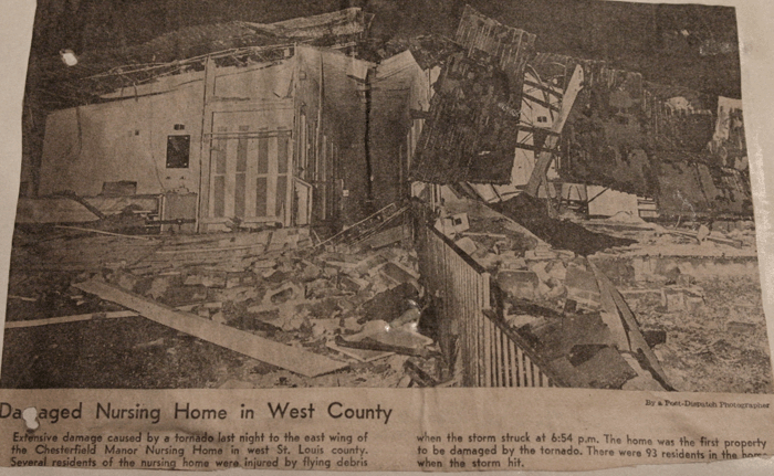
Chesterfield Manor Nursing Home
Bridgeton Westhaven Subdivision
St. Ann Library
Ferguson Damage Chambers Rd
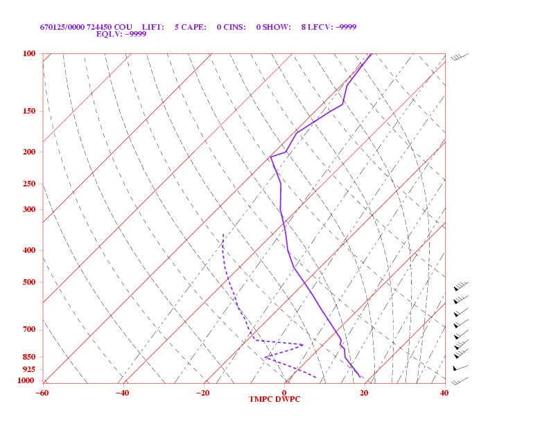
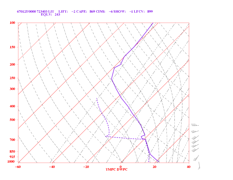
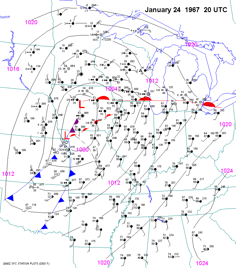
WEATHER DATA 01-24-1967 SOUNDINGS MAP ANALYSIS |
On January 24th 1967, a violent F4 tornado ripped a 21 mile long path of destruction across St. Louis County.
The tornado initially touched down around 6:55 p.m. in western St. Louis County at Olive Street Road near the Howard Bend Pumping Station where damage was reported to the Chesterfield Manor Nursing Home. The tornado moved northeast at 40 mph striking the small community of Lake, the luxury homes at River Bend Estates and Old Farm Estates valued between $25,000 and $33,000 (1967 dollars), Creve Coeur Meadows and Glenwood Subdivisions, and the heavily populated communities of Maryland Heights, Bridgeton, St. Ann, Edmundson, Woodson Terrace, Berkeley, Ferguson, Dellwood, the Hathaway Manor Subdivision, and Spanish Lake. The tornado apparently dissipated or weakened as it crossed the Mississippi River, as there is no record of significant damage in Illinois. The damage path ranged from 50 to 200 yards wide and the tornado was on the ground for approximately 35 minutes. Remarkably only 3 fatalities were reported while 216 people suffered injuries. Damage included 168 homes destroyed, 258 with major damage, and 1485 with minor damage. At least 600 businesses were damaged or destroyed. The total damage was estimated to be around 15 million dollars (approximately 125 million dollars in 2022). The tornado was given a F4 rating on the Fujita Tornado Ranking Scale. The F4 occurrence was likely small in aerial coverage with the majority of the severe damage being classified as either F2 or F3. Eight other tornadoes struck Missouri that day with 32 tornadoes in all occurring from Oklahoma to Wisconsin. The Wisconsin tornado is believed to be the farthest north tornado ever recorded in January. Many people will remember that the bad weather continued across Missouri January 25th and 26th with freezing rain and snow following this historic winter tornado outbreak. NATIONAL WEATHER SERVICE (WEATHER BUREAU IN 1967) The National Weather Service, then known as the Weather Bureau, had both its office and WSR-57 Radar located at Lambert Field. At 5:40 p.m. that evening, severe thunderstorms were detected on radar by radar operators and a severe thunderstorm warning was issued. Weather officials received a telephone call from the Creve Coeur area shortly after 7:00 p.m. and learned that a tornado was on the ground. A tornado warning was issued shortly thereafter. With the tornado passing just south of the airport, near the intersection of Woodson and Natural Bridge Roads, the weather office lost phone service between 7:30 and 10:00 p.m. The radar remained operational throughout the event. While the radar film for this tornado has not been analyzed in recent years, it is likely that the proximity of the tornado to the radar, the limitations of radar technology in the 1960s, and a lack of understanding about supercell thunderstorms, prevented the detection of the tornado. TORNADO RESEARCH ...THEN AND NOW... Tornado research, and our understanding of tornadoes, has come a long way since 1967! For instance, in an article about this tornado, the St. Louis Globe Democrat wrote, "Tornadoes are generally caused by electric currents in the air, and are generated by high speed flow of water droplets between positive and negative clouds". Today, we know that most violent tornadoes occur with supercells, which are rotating thunderstorms with a well-defined radar circulation called a mesocyclone. While the exact mechanism that produces tornadoes still remains unknown, it is believed that tornado formation is dictated mainly by things which happen on the storm scale, in and around the mesocyclone. Recent theories, and research from the the Verification of the Origins of Rotation in Tornadoes Experiment (VORTEX) project, suggest that once a mesocyclone has developed, tornado development is related to the temperature differences around the edge of the downdraft air wrapping around the mesocyclone. However, other studies suggest that tornado formation can happen without such temperature patterns. Meteorologists at the National Weather Service in St. Louis continue to research and document tornado climatology for the St. Louis county warning area. |


.gif)


 Weather Story
 Weather Map
 Local Radar