Please remember that weather conditions can change rapidly so you are encouraged to check back often for the latest forecasts. For general forecast information, visit the National Weather Service (NWS) St. Louis, MO homepage.
NWS St. Louis Excessive Heat Advisory/Warning criteria. Note: Heat Index = HI
Excessive Heat Advisory: The HI is expected to be around 105 degrees F. Or the HI will range from 100 - 104 for at least 4 consecutive days.
Excessive Heat Warning: The HI is expected to be around 110 degrees F for two days, or the HI will be around 105 degrees for 4 consecutive days.
Temperature and HI forecast for the next 7 days
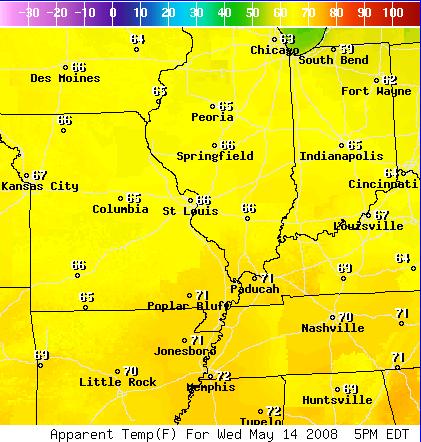
The link above will take you to the National Digital Forecast Database data from the National Weather Service, St. Louis. For the HI, look for the Apparent Temperature field. In winter, this will be the wind chill Index.
The Hydrometeorological Prediction Center in Washington, DC also posts Heat Index information for the entire country. Click on the links below to view this data.
Preliminary, National Day 3 - 7 Heat Index Forecast
 |
| Day 3 - Day 7 |
Climate Prediction Center
The Climate Prediction Center (CPC) is releasing longer range, 6 - 10 day and 8 to 14 day, excessive heat index probability charts. The following links will take you to the appropriate Internet page.
Climate Prediction Center Heat Index and Max Temperature 6 - 10 Day Outlook
Climate Prediction Center Heat Index and Max Temperature 8 - 14 Day Outlook
Climate Prediction Center Three Month Temperature and Precipitation Outlooks
Heat Index
The National Weather Service uses the Heat Index (HI) to compute the "apparent temperature," which is a measure of how hot it feels to people at a certain combination of temperature and humidity. The heat index values used in forecasts, advisories, and warnings assume an average size adult, with light clothing, in the shade, with a 5 mile per hour wind. Being in full sun, or in an area with little air movement, can increase the apparent temperature, and thus increase the risk for adverse effects from the heat and humidity. Winds greater than 5 miles per hour usually enhance evaporative cooling and decrease the apparent temperature and the health threat from the heat. As noted, the impacts of heat are cumulative over time. The greatest number of heat-induced illnesses and fatalities usually peak two days after the maximum heat index values occurred.

For heat related safety information visit the Missouri Summer Weather Safety Week page.


 Weather Story
 Weather Map
 Local Radar