Overview
A broken line of supercellular thunderstorms (rotating thunderstorms) broke out on the afternoon of Saturday, December 1st, 2018. Three of of these thunderstorms produced multiple tornadoes across portions of western and central Illinois. Below are the tornadoes that affected the NWS St. Louis county warning area. For more detailed, interactive maps, please visit:
https://apps.dat.noaa.gov/StormDamage/DamageViewer/
Tornadoes:
Tornado 1 - Pleasant Hill, IL
PIKE COUNTY, IL
| Date |
12/1/2018 |
| Time (Local) |
1:54 PM CST |
| EF Rating |
EF-1 |
| Est. Peak Winds |
98 mph |
| Path Length |
1.68 miles |
| Max Width |
25 yards |
| Injuries/Deaths |
0/0 |
|
Summary:
The tornado began about 1 mile east of Pleasant Hill, IL and remained on the ground for about 4 minutes with a path that skipped to the northeast of Pleasant Hill. A grain bin sustained damaged along 130th Avenue near the beginning of the track. The path then continued to the northeast where a barn was rolled about 20 yards off its foundation. Another barn sustained heavy roof damage. The tornado continued northeast toward 147th Street where some large trees sustained damage. The tornado lifted as it pushed northeast of 147th Street.
|
Track Map
 
|
Tornado 2 - Detroit, IL
PIKE COUNTY, IL
| Date |
12/1/2018 |
| Time (Local) |
2:29 PM CST |
| EF Rating |
EF-0 |
| Est. Peak Winds |
85 mph |
| Path Length |
0.11 miles |
| Max Width |
25 yards |
| Injuries/Deaths |
0/0 |
|
Summary:
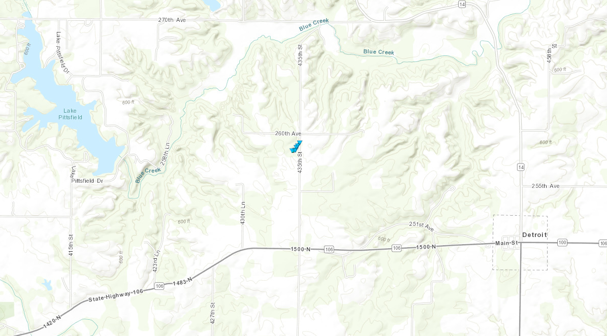
This short lived tornado began 2 miles northwest of Detroit, IL, along 435th street. Damage was primarily confined to trees, but there was a home with roof damage and a large camper was blown on its side.
|
Track Map
 
|
Tornado 3 - Valley City, IL
PIKE COUNTY, IL
| Date |
12/1/2018 |
| Time (Local) |
2:40 PM CST |
| EF Rating |
EF-1 |
| Est. Peak Winds |
110 mph |
| Path Length |
0.60 miles |
| Max Width |
110 yards |
| Injuries/Deaths |
0/0 |
|
Summary:
The tornado began about 1 mile NNW of Valley City, IL. Along County Highway 21, trees were uprooted and a mobile home lost its roof and sustained wall damage. The tornado continued to the northeast, crossing County Highway 21 twice, before lifting. Along this path there was significant tree damage along the east side of Highway 21.
|
Track Map
 
|
Tornado 4 - Staunton, IL
MACOUPIN COUNTY, IL
| Date |
12/1/2018 |
| Time (Local) |
3:59 PM CST |
| EF Rating |
EF-1 |
| Est. Peak Winds |
110 mph |
| Path Length |
1.39 miles |
| Max Width |
50 yards |
| Injuries/Deaths |
0/0 |
|
Summary:
An EF-1 tornado touched down over the Country Classic Cars business northeast of Staunton, IL. Many videos surfaced showing a funnel develop and pass over Interstate 55. No damage could be seen west of the interstate, creating the initial damage to a carport at the business, then cutting an approximately 50 yard path through the middle portion of the second storage shed on the property. The tornado moved northeast, depositing several pieces of sheet metal and wood onto Old Route 66 and fields to the east. Despite visible power flashes in videos, power lines looked untouched. A house, two farm buildings and trees were damaged on the south side of Tall Timber Road. Another structure to the north side of Tall Timber Road, at the end of Adden Road, was also damaged. Several pieces of debris could be seen in the field to the northeast of the of Adden Road and to the west of Two Mile Road. However, no damage was assessed past the field, where it is likely the tornado dissipated. Additional videos from Mt. Olive show a long rope funnel ascended above the town with no damage to the community.
|
Track Map
 
|
Tornado 5 - Raymond, IL
MONTGOMERY COUNTY, IL
| Date |
12/1/2018 |
| Time (Local) |
4:09 PM CST |
| EF Rating |
EF-1 |
| Est. Peak Winds |
100 mph |
| Path Length |
8.02 miles |
| Max Width |
75 yards |
| Injuries/Deaths |
0/0 |
|
Summary:
The tornado initially touched down just to the west of Interstate 55, along 1st Road. Power poles were snapped in this location. The tornado continued to the northeast, doing some damage to farm buildings along 17th Avenue. The tornado continued northeast towards Highway 108 where several trees were snapped. The worst damage was along Highway 48 just west of Raymond, IL where a family residence sustained major roof damage and damage to the garage. The tornado then lifted somewhere near 3rd Avenue to the northwest of Raymond, IL.
|
Track Map
 
|
Tornado 6 - Litchfield - Butler, IL
MONTGOMERY COUNTY, IL
| Date |
12/1/2018 |
| Time (Local) |
4:16 PM CST |
| EF Rating |
EF-2 |
| Est. Peak Winds |
115 mph |
| Path Length |
7.93 miles |
| Max Width |
100 yards |
| Injuries/Deaths |
0/0 |
|
Summary:
The tornado first touched down just southeast of Litchfield, IL, along Old Litchfield Trail where large tree branches were snapped. The damage worsened as the tornado moved northeast, where a large farm building was destroyed near Highway 16. The tornado then crossed to the north of Highway 16, doing damage along Rocky Hollow Trail. This area sustained the worst of the tornadic damage, where several farm buildings were destroyed. A brick family residence sustained major roof damage and suffered a partial loss of its walls in this location as well. The tornado then continued to the northeast, weakening and eventually lifting as it turned to the west towards 7th Road.
|
Track Map
 
|
Tornado 7 -Blue Grass Creek
MONTGOMERY COUNTY, IL
| Date |
12/1/2018 |
| Time (Local) |
4:32 PM CST |
| EF Rating |
EF-1 |
| Est. Peak Winds |
100 mph |
| Path Length |
2.00 miles |
| Max Width |
50 yards |
| Injuries/Deaths |
0/0 |
|
Summary:
The tornado began southeast of Raymond, IL along Highway 127 where several trees were uprooted. The tornado continued northeast, crossing over Blue Grass Creek where it continued to do mainly tree damage. The worst damage was found near Oil Field Road, where a few outbuildings were destroyed. A family residence sustained some minor roof and shingle damage as the tornado crossed Oil Field Road and dissipated.
|
Track Map
 
|
Tornado 8 - Harvel, IL
MONTGOMERY INTO CHRISTIAN COUNTY, IL
| Date |
12/1/2018 |
| Time (Local) |
4:47 PM CST |
| EF Rating |
EF-0 |
| Est. Peak Winds |
80 mph |
| Path Length |
3.12 miles |
| Max Width |
200 yards |
| Injuries/Deaths |
0/0 |
|
Summary:
A weak EF-0 tornado touched down near the junction of East 13th Road and East 000 Road, just south of the Montgomery and Christian County line. The tornado damaged a farm storage building, before entering Christian County. The tornado lifted northeast towards E 200th Road where it did some damage to additional farm outbuildings and uprooted some trees.
|
Track Map
 
|
The Enhanced Fujita (EF) Scale classifies tornadoes into the following categories:
EF0
Weak
65-85 mph |
EF1
Moderate
86-110 mph |
EF2
Significant
111-135 mph |
EF3
Severe
136-165 mph |
EF4
Extreme
166-200 mph |
EF5
Catastrophic
200+ mph |
 |


