Overview
A line of severe thunderstorms initially developed over southeast Iowa on the morning of June 28th, 2018. A moist and unstable airmass out ahead of these storms allowed them to strengthen as they moved southeast, reaching peak intensity as they moved through portions of the northern and eastern St. Louis metro area and western Illinois. Significant and fairly widespread wind damage occurred from these storms Thursday afternoon into Thursday evening, with even a weak tornado hitting near Elsah, IL.Tornadoes:
|
Tornado - Elsah, IL
Track Map 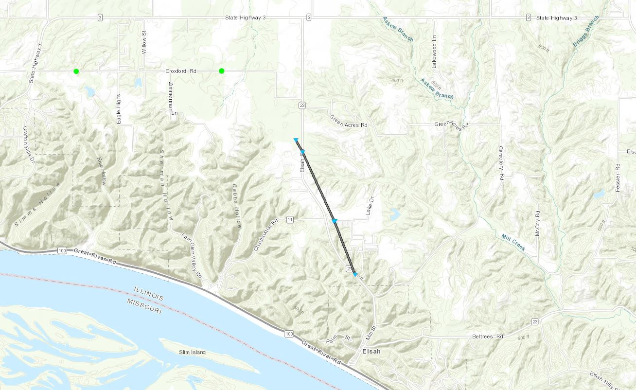 
|
||||||||||||||||
The Enhanced Fujita (EF) Scale classifies tornadoes into the following categories:
| EF0 Weak 65-85 mph |
EF1 Moderate 86-110 mph |
EF2 Significant 111-135 mph |
EF3 Severe 136-165 mph |
EF4 Extreme 166-200 mph |
EF5 Catastrophic 200+ mph |
 |
|||||
Wind:
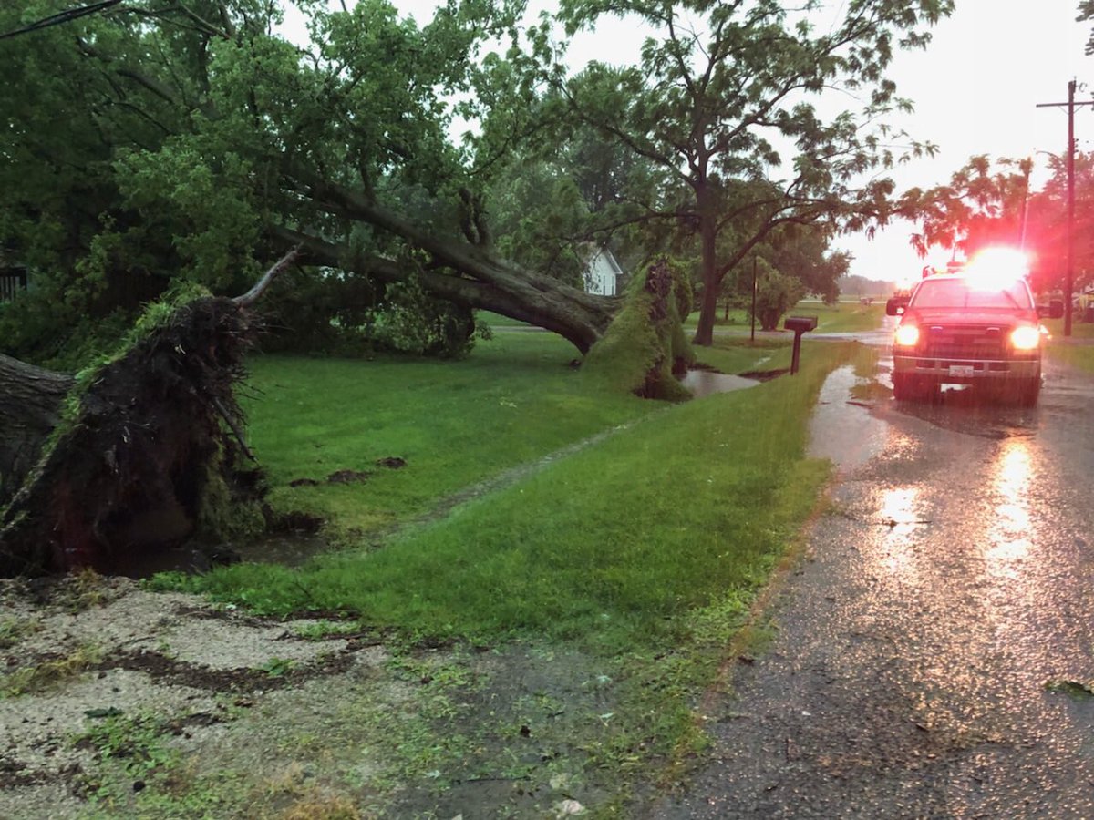
Fairly widespread wind damage was reported across northern portions of the St. Louis metro area and across much of western and southwest Illinois, where winds were estimated at 60-80 mph. Below are a few of the pictures we received of the more significant damage.
 |
 |
 |
 |
| A marina in Portage Des Sioux sustained heavy damage. (Image courtesy of KMOV) | A marina in Portage Des Sioux sustained heavy damage. (Image courtesy of KMOV) | Trees were toppled in portions of Granite City, IL. (Image courtesy of Nathan Langendorf) | Spanish Lake residents sustained significant tree damage. (Image courtesy of Ryan Michalesko) |
Radar:
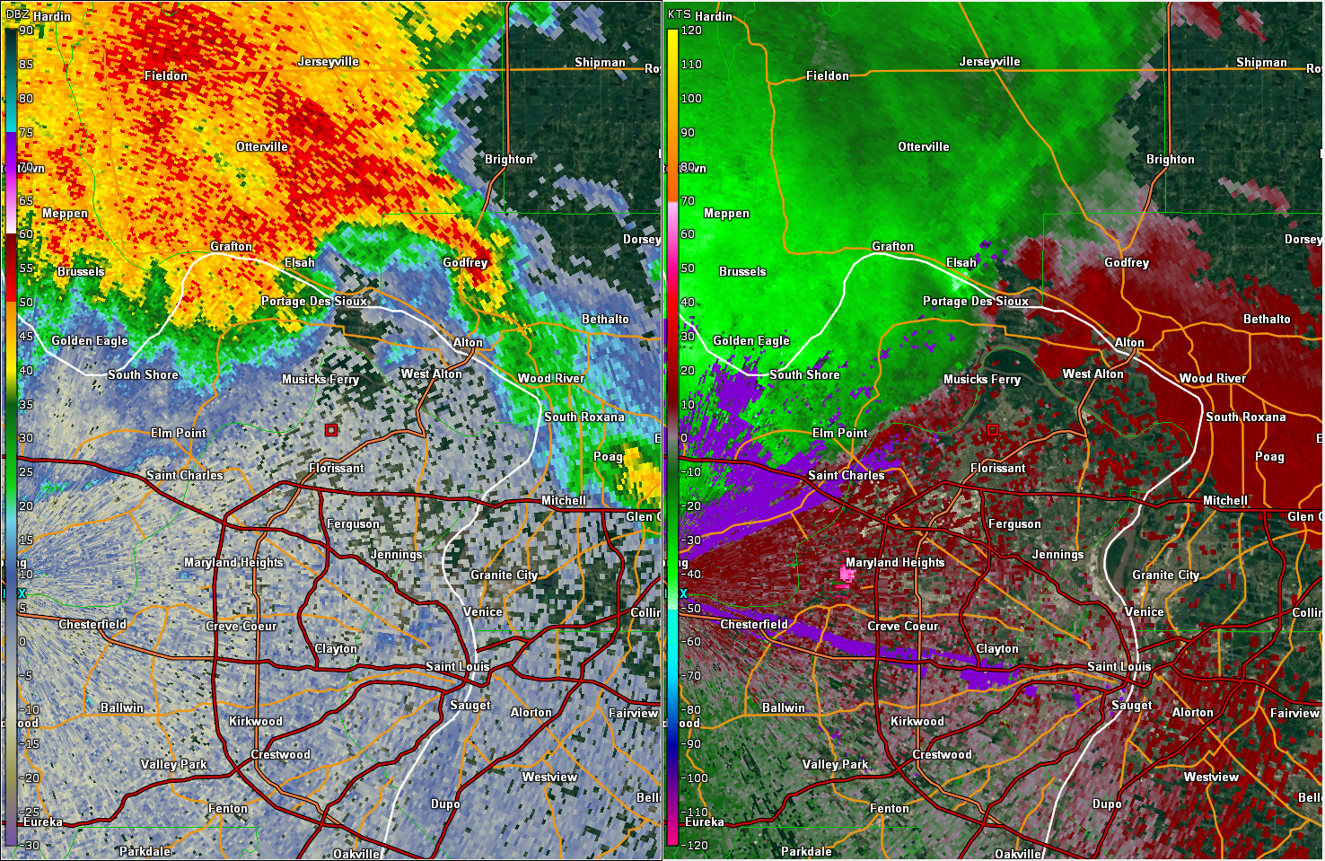
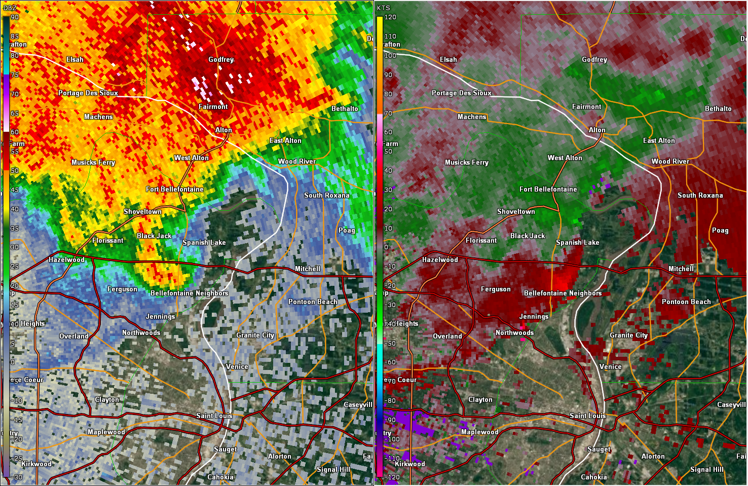
Here are some radar images as the storms plowed southeast across the region.
 |
 |
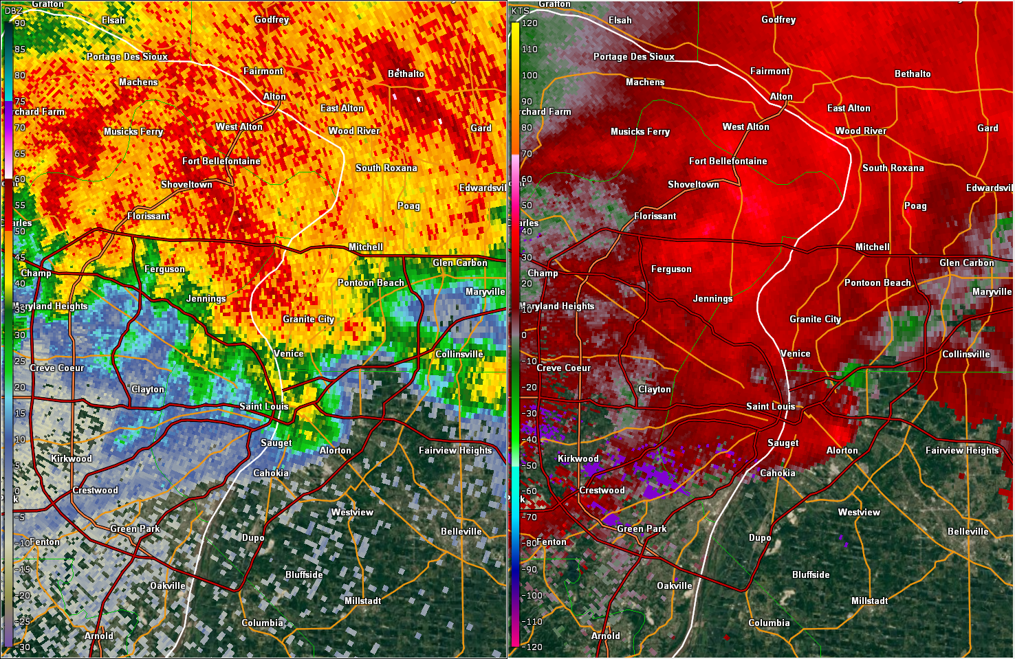 |
| Radar reflectivity (left) and velocity data (right) near the time of the Elsah, IL tornado. | Radar reflectivity (left) and velocity data (right) as the storm went through Spanish Lake. | Radar reflectivity (left) and velocity data (right) as the storm went through Granite City, IL. |
Storm Reports
Below is a list of the storm reports received at the NWS St. Louis office.
..TIME... ...EVENT... ...CITY LOCATION... ...LAT.LON...
..DATE... ....MAG.... ..COUNTY LOCATION..ST.. ...SOURCE....
..REMARKS..
1027 PM Heavy Rain Desloge 37.88N 90.52W
06/28/2018 M2.64 inch St. Francois MO Trained Spotter
Storm total from spotter.
1027 PM Heavy Rain Desloge 37.88N 90.52W
06/28/2018 M2.64 inch St. Francois MO Trained Spotter
Storm total from spotter.
1010 PM Flash Flood Bonne Terre 37.93N 90.55W
06/28/2018 St. Francois MO Trained Spotter
1 foot of standing water over Highway K in
Bonne Terre.
1010 PM Flash Flood Bonne Terre 37.93N 90.55W
06/28/2018 St. Francois MO Trained Spotter
1 foot of standing water over Highway K in
Bonne Terre.
1000 PM Heavy Rain Belleville 38.53N 90.00W
06/28/2018 M3.02 inch St. Clair IL Public
Rainfall total from 6:00 PM to approximately
9:30 PM on 6/28/2018.
1000 PM Heavy Rain Belleville 38.53N 90.00W
06/28/2018 M3.02 inch St. Clair IL Public
Rainfall total from 6:00 PM to approximately
9:30 PM on 6/28/2018.
0945 PM Flash Flood 2 E Leadington 37.83N 90.44W
06/28/2018 St. Francois MO Law Enforcement
Widespread road flooding reported across St
Francois county.
0945 PM Flash Flood 2 E Leadington 37.83N 90.44W
06/28/2018 St. Francois MO Law Enforcement
Widespread road flooding reported across St
Francois county.
0923 PM Flash Flood Freeburg 38.43N 89.91W
06/28/2018 St. Clair IL Law Enforcement
Flash flooding continues across much of SE
St Clair county. Several roads flooded in
that area.
0923 PM Flash Flood Freeburg 38.43N 89.91W
06/28/2018 St. Clair IL Law Enforcement
Flash flooding continues across much of SE
St Clair county. Several roads flooded in
that area.
0850 PM Hail 2 S Potosi 37.91N 90.78W
06/28/2018 M0.50 inch Washington MO Trained Spotter
Dime size hail reported 2 miles south of
Potosi.
0850 PM Hail 2 S Potosi 37.91N 90.78W
06/28/2018 M0.50 inch Washington MO Trained Spotter
Dime size hail reported 2 miles south of
Potosi.
0835 PM Hail Desloge 37.87N 90.52W
06/28/2018 E0.88 inch St. Francois MO Trained Spotter
0835 PM Hail Desloge 37.87N 90.52W
06/28/2018 E0.88 inch St. Francois MO Trained Spotter
0801 PM Tstm Wnd Dmg 3 W Libertyville 37.71N 90.34W
06/28/2018 St. Francois MO Public
Public photo on social media: Large limb or
part of a large tree was blown down. Limb
caused minor damage to the gutter of the
house.
0801 PM Tstm Wnd Dmg 3 W Libertyville 37.71N 90.34W
06/28/2018 St. Francois MO Public
Public photo on social media: Large limb or
part of a large tree was blown down. Limb
caused minor damage to the gutter of the
house.
0800 PM Tstm Wnd Dmg 2 E Bismarck 37.77N 90.59W
06/28/2018 St. Francois MO Public
Trees and power lines down across Highway N.
0800 PM Tstm Wnd Dmg 2 E Bismarck 37.77N 90.59W
06/28/2018 St. Francois MO Public
Trees and power lines down across Highway N.
0753 PM Tstm Wnd Dmg 1 SE Maeystown 38.22N 90.22W
06/28/2018 Monroe IL Law Enforcement
Sporadic trees down in town.
0753 PM Tstm Wnd Dmg 1 SE Maeystown 38.22N 90.22W
06/28/2018 Monroe IL Law Enforcement
Sporadic trees down in town.
0746 PM Flash Flood 2 SE Belleville 38.51N 89.98W
06/28/2018 St. Clair IL Public
Report via social media of backyards being
submerged.
0746 PM Flash Flood 2 SE Belleville 38.51N 89.98W
06/28/2018 St. Clair IL Public
Report via social media of backyards being
submerged.
0740 PM Heavy Rain 1 S Mascoutah 38.46N 89.79W
06/28/2018 M2.80 inch St. Clair IL Public
Delayed report: Rain report submitted on
social media. Rainfall total occurred over
an approximate span of 2 hours.
0740 PM Hail 1 ESE Hillsboro 38.23N 90.56W
06/28/2018 M1.25 inch Jefferson MO Public
Correction from earlier report: delayed
report: public photo shared via social
media. time is estimated by radar.
0732 PM Hail Prairie Du Rocher 38.08N 90.10W
06/28/2018 E1.00 inch Randolph IL Broadcast Media
Photo of quarter-sized hail. Time estimated
from radar.
0732 PM Hail Prairie Du Rocher 38.08N 90.10W
06/28/2018 E1.00 inch Randolph IL Broadcast Media
Photo of quarter-sized hail. Time estimated
from radar.
0730 PM Flash Flood Centreville 38.58N 90.11W
06/28/2018 St. Clair IL Trained Spotter
Spotter reported lanes of southbound
interstate 255 submerged.
0730 PM Heavy Rain 3 SSW Godfrey 38.93N 90.21W
06/28/2018 M2.11 inch Madison IL Cocorahs
Rainfall in 75 minutes.
0730 PM Flash Flood 2 NNW Houston 38.19N 89.79W
06/28/2018 Randolph IL Law Enforcement
County Road 18 closed due to flooding. Time
approximated.
0722 PM Tstm Wnd Dmg Oakland 38.58N 90.38W
06/28/2018 St. Louis MO Public
Large tree down by railroad crossing.
0722 PM Tstm Wnd Dmg Oakland 38.58N 90.38W
06/28/2018 St. Louis MO Public
Large tree down by railroad crossing.
0637 PM Tstm Wnd Gst 2 E Centralia 38.52N 89.09W
06/28/2018 M52 MPH Marion IL AWOS
0637 PM Tstm Wnd Gst 2 E Centralia 38.52N 89.09W
06/28/2018 M52 MPH Marion IL AWOS
0631 PM Tstm Wnd Dmg Centralia 38.53N 89.13W
06/28/2018 Marion IL Broadcast Media
Numerous trees snapped. Time estimated from
radar. Twitter report.
0631 PM Tstm Wnd Dmg Centralia 38.53N 89.13W
06/28/2018 Marion IL Broadcast Media
Numerous trees snapped. Time estimated from
radar. Twitter report.
0630 PM Tstm Wnd Gst 2 E Centralia 38.52N 89.09W
06/28/2018 M41 MPH Marion IL AWOS
0630 PM Tstm Wnd Gst Hoyleton 38.45N 89.27W
06/28/2018 E45 MPH Washington IL Trained Spotter
0630 PM Tstm Wnd Gst 2 E Centralia 38.52N 89.09W
06/28/2018 M41 MPH Marion IL AWOS
0630 PM Tstm Wnd Gst Hoyleton 38.45N 89.27W
06/28/2018 E45 MPH Washington IL Trained Spotter
0629 PM Tstm Wnd Gst 1 SSE Tonti 38.65N 88.97W
06/28/2018 M44 MPH Marion IL AWOS
0629 PM Tstm Wnd Gst 1 SSE Tonti 38.65N 88.97W
06/28/2018 M44 MPH Marion IL AWOS
0628 PM Tstm Wnd Dmg Nashville 38.35N 89.38W
06/28/2018 Washington IL Public
Widespread tree damage across Washington
County.
0628 PM Tstm Wnd Dmg Nashville 38.35N 89.38W
06/28/2018 Washington IL Public
Widespread tree damage across Washington
County.
0623 PM Tstm Wnd Dmg Bartelso 38.54N 89.47W
06/28/2018 Clinton IL Trained Spotter
Trained spotter reported 4 to 5 inch
diameter tree limbs down.
0623 PM Tstm Wnd Dmg Bartelso 38.54N 89.47W
06/28/2018 Clinton IL Trained Spotter
Trained spotter reported 4 to 5 inch
diameter tree limbs down.
0620 PM Tstm Wnd Dmg Sandoval 38.61N 89.12W
06/28/2018 Marion IL Public
Delayed Report: Social media user submitted
several picture of wind damage to trees.
Multiple large limbs were down in the yard.
0620 PM Flood 2 WSW Granite City 38.70N 90.16W
06/28/2018 Madison IL Public
Street flooding in Granite City. Twitter
report.
0618 PM Tstm Wnd Dmg Aviston 38.61N 89.61W
06/28/2018 Clinton IL Trained Spotter
Part of the roof of the Aviston Family
Restaurant is missing.
0618 PM Tstm Wnd Dmg Aviston 38.61N 89.61W
06/28/2018 Clinton IL Trained Spotter
Part of the roof of the Aviston Family
Restaurant is missing.
0615 PM Tstm Wnd Dmg Germantown 38.56N 89.54W
06/28/2018 Clinton IL Trained Spotter
Numerous trees blown down. Time estimated by
radar.
0615 PM Tstm Wnd Dmg Germantown 38.56N 89.54W
06/28/2018 Clinton IL Trained Spotter
Numerous trees blown down. Time estimated by
radar.
0610 PM Tstm Wnd Dmg Germantown 38.55N 89.54W
06/28/2018 Clinton IL Public
Large trees down.
0610 PM Tstm Wnd Dmg Germantown 38.55N 89.54W
06/28/2018 Clinton IL Public
Large trees down.
0608 PM Tstm Wnd Dmg Aviston 38.61N 89.60W
06/28/2018 Clinton IL Trained Spotter
6 inch in diameter tree limb down and at
least 50 mph wind gust. Currently without
power.
0608 PM Tstm Wnd Dmg Aviston 38.61N 89.60W
06/28/2018 Clinton IL Trained Spotter
6 inch in diameter tree limb down and at
least 50 mph wind gust. Currently without
power.
0607 PM Tstm Wnd Dmg Albers 38.55N 89.62W
06/28/2018 Clinton IL Trained Spotter
Power poles down in town. Estimated by
radar.
0607 PM Tstm Wnd Dmg 1 NNE Scott Afb 38.56N 89.84W
06/28/2018 St. Clair IL Law Enforcement
Large trees down and debris.
0607 PM Tstm Wnd Dmg Albers 38.55N 89.62W
06/28/2018 Clinton IL Trained Spotter
Power poles down in town. Estimated by
radar.
0607 PM Tstm Wnd Dmg 1 NNE Scott Afb 38.56N 89.84W
06/28/2018 St. Clair IL Law Enforcement
Large trees down and debris.
0605 PM Tstm Wnd Dmg 2 E Centreville 38.57N 90.07W
06/28/2018 St. Clair IL Public
Public report via social media of trees and
power poles snapped off. Time estimated from
radar.
0605 PM Tstm Wnd Dmg 1 S Scott Afb 38.53N 89.85W
06/28/2018 St. Clair IL Public
Delayed Report: Small tree snapped at the
base. Based is judged to be 10 to 12 inches
in diameter.
0603 PM Funnel Cloud 1 N Millstadt 38.48N 90.09W
06/28/2018 St. Clair IL Trained Spotter
Spotter saw funnel from the city of
Columbia, IL.
0603 PM Tstm Wnd Dmg 2 ESE Fairview Heights 38.58N 89.98W
06/28/2018 St. Clair IL Broadcast Media
Minor damage to an apartment complex along
Joseph Drive in Fairview Heights. Time
estimated from radar.
0602 PM Tstm Wnd Dmg Saint Jacob 38.72N 89.77W
06/28/2018 Madison IL Public
Tree down at Douglas and Third Street. Time
estimated by radar.
0602 PM Tstm Wnd Dmg 1 ESE Belleville 38.53N 89.98W
06/28/2018 St. Clair IL Public
Report via social media of tree uprooted.
Time estimated from radar.
0602 PM Tstm Wnd Dmg Fairview Heights 38.60N 90.00W
06/28/2018 St. Clair IL Trained Spotter
Several trees down.
0602 PM Tstm Wnd Dmg 2 SE Swansea 38.53N 89.97W
06/28/2018 St. Clair IL Public
Delayed report: Few limbs down at the 1700
Block of LaSalle.
0602 PM Tstm Wnd Dmg Greenville 38.89N 89.40W
06/28/2018 Bond IL Emergency Mngr
Tree down across power line.
0600 PM Tstm Wnd Gst 1 SE Sauget 38.58N 90.16W
06/28/2018 M50 MPH St. Clair IL ASOS
0600 PM Tstm Wnd Dmg Brownstown 39.00N 88.95W
06/28/2018 Fayette IL Law Enforcement
Tree downed on car. Additional reports of
trees and power lines down sporadically
across the county.
0600 PM Tstm Wnd Gst 1 SE Sauget 38.58N 90.16W
06/28/2018 M50 MPH St. Clair IL ASOS
0600 PM Tstm Wnd Dmg Brownstown 39.00N 88.95W
06/28/2018 Fayette IL Law Enforcement
Tree downed on car. Additional reports of
trees and power lines down sporadically
across the county.
0558 PM Tstm Wnd Dmg 1 SE Fairview Heights 38.59N 89.99W
06/28/2018 St. Clair IL Public
Delayed report: Large healthy tree snapped
at the base near the intersection of S Ruby
Lane and St. Clair Drive. Photo submitted
via social media.
0558 PM Funnel Cloud Caseyville 38.63N 90.03W
06/28/2018 St. Clair IL Trained Spotter
Funnel Cloud spotted at the intersection of
Bethel Mine Road and North Illinois Street
in Caseyville.
0557 PM Tstm Wnd Dmg Oakland 38.58N 90.38W
06/28/2018 St. Louis MO Public
Report via social media of tree down. Time
estimated from radar.
0557 PM Tstm Wnd Dmg Oakland 38.58N 90.38W
06/28/2018 St. Louis MO Public
Report via social media of tree down. Time
estimated from radar.
0556 PM Tstm Wnd Dmg 2 NNW Saint Louis 38.66N 90.26W
06/28/2018 St. Louis City MO Amateur Radio
Large healthy trees toppled.
0556 PM Tstm Wnd Dmg 2 NNW Saint Louis 38.66N 90.26W
06/28/2018 St. Louis City MO Amateur Radio
Large healthy trees toppled.
0555 PM Tstm Wnd Dmg Highland 38.74N 89.68W
06/28/2018 Madison IL Amateur Radio
Several wooden fences down. Power outages
also reported.
0555 PM Tstm Wnd Dmg Highland 38.74N 89.68W
06/28/2018 Madison IL Amateur Radio
Several wooden fences down. Power outages
also reported.
0554 PM Tstm Wnd Dmg 2 NNE Saint Louis 38.66N 90.23W
06/28/2018 St. Louis City MO Broadcast Media
Media report via social media. Trees and
power lines down. Time estimated from radar.
0554 PM Tstm Wnd Dmg 2 NNE Saint Louis 38.66N 90.23W
06/28/2018 St. Louis City MO Broadcast Media
Media report via social media. Trees and
power lines down. Time estimated from radar.
0553 PM Tstm Wnd Dmg 3.5 SSW Godfrey 38.92N 90.21W
06/28/2018 Madison IL Trained Spotter
Trees uprooted and machine shed completely
destroyed.
0553 PM Tstm Wnd Dmg 3.5 SSW Godfrey 38.92N 90.21W
06/28/2018 Madison IL Trained Spotter
Trees uprooted and machine shed completely
destroyed.
0549 PM Tstm Wnd Dmg 2 W Collinsville 38.68N 90.03W
06/28/2018 Madison IL Trained Spotter
Tractor Trailer blown over at the
intersection of I-55 and 203 via social
media post. Time estimated by radar.
0549 PM Tstm Wnd Dmg Granite City 38.71N 90.13W
06/28/2018 Madison IL Public
several large trees down in Wilson park.
0546 PM Tstm Wnd Dmg Fairmont City 38.65N 90.11W
06/28/2018 St. Clair IL Public
Delayed report: Several limbs down, some
snapped at the midpoint of the trees. Many
smaller tree limbs and debris scattered
about the ground.
0546 PM Tstm Wnd Dmg 2 SE Madison 38.66N 90.13W
06/28/2018 Madison IL Public
500 ft radio broadcast tower knocked down.
0545 PM Tstm Wnd Dmg Glen Carbon 38.76N 89.97W
06/28/2018 Madison IL Public
Small tree snapped. Facebook report.
0545 PM Tstm Wnd Dmg Glen Carbon 38.76N 89.97W
06/28/2018 Madison IL Public
Small tree snapped. Facebook report.
0544 PM Tstm Wnd Dmg 1 SW Granite City 38.70N 90.14W
06/28/2018 Madison IL Broadcast Media
Media report via social media of tree down
in Granite City.
0544 PM Tstm Wnd Dmg 1 WSW Granite City 38.71N 90.14W
06/28/2018 Madison IL Broadcast Media
Media report via social media of large trees
uprooted. Time estimated from radar.
0542 PM Tstm Wnd Dmg 2 WSW Alton 38.89N 90.18W
06/28/2018 Madison IL Trained Spotter
4 to 5 inch diameter tree limbs down.
0542 PM Tstm Wnd Dmg 3 ESE Saint Louis 38.63N 90.19W
06/28/2018 St. Louis City MO Public
Light pole snapped near base. Time estimated
from radar. Twitter report.
0542 PM Tstm Wnd Dmg 2 WSW Alton 38.89N 90.18W
06/28/2018 Madison IL Trained Spotter
4 to 5 inch diameter tree limbs down.
0542 PM Tstm Wnd Dmg 3 ESE Saint Louis 38.63N 90.19W
06/28/2018 St. Louis City MO Public
Light pole snapped near base. Time estimated
from radar. Twitter report.
0541 PM Tstm Wnd Dmg 1 ENE Edwardsville 38.80N 89.95W
06/28/2018 Madison IL Public
Delayed report via social media: Public
stated that several large and healthy trees
were down throughout parts of Edwardsville.
A couple of trees were on power lines.
0541 PM Tstm Wnd Dmg 2 WNW Bridgeton 38.78N 90.46W
06/28/2018 St. Louis MO Public
Report via social media of large tree limb
down.
0541 PM Tstm Wnd Dmg 2 NNW Saint Louis 38.66N 90.26W
06/28/2018 St. Louis City MO Public
Large tree uprooted blocking Fountain
Avenue.
0541 PM Tstm Wnd Dmg 2 W Saint Louis 38.63N 90.29W
06/28/2018 St. Louis City MO Public
Delayed report: Large tree down near the
round about heading into Forrest Park near
the zoo off 64/40.
0541 PM Tstm Wnd Dmg Worden 38.93N 89.84W
06/28/2018 Madison IL Public
Picture of two trees uprooted received via
twitter post.
0538 PM Tstm Wnd Dmg 1 ESE Riverview 38.75N 90.20W
06/28/2018 St. Louis MO Broadcast Media
Large tree branches on power lines and
blocking Riverview Drive near Chambers road.
0538 PM Tstm Wnd Dmg 1 NNW Ferguson 38.76N 90.30W
06/28/2018 St. Louis MO Public
Report via social media of tree down.
0538 PM Tstm Wnd Dmg 1 ESE Riverview 38.75N 90.20W
06/28/2018 St. Louis MO Broadcast Media
Large tree branches on power lines and
blocking Riverview Drive near Chambers road.
0538 PM Tstm Wnd Dmg 1 NNW Ferguson 38.76N 90.30W
06/28/2018 St. Louis MO Public
Report via social media of tree down.
0536 PM Tstm Wnd Dmg 2 WNW Spanish Lake 38.80N 90.23W
06/28/2018 St. Louis MO Amateur Radio
Corrects previous tstm wnd dmg report from 2
WNW Spanish Lake. Bus stop bench blown into
the street and many limbs down.
0536 PM Tstm Wnd Dmg 2 WNW Spanish Lake 38.80N 90.23W
06/28/2018 St. Louis MO Amateur Radio
Corrects previous tstm wnd dmg report from 2
WNW Spanish Lake. Bus stop bench blown into
the street and many limbs down.
0534 PM Tstm Wnd Dmg 2 WSW Alton 38.89N 90.18W
06/28/2018 Madison IL Public
Large tree down and fell on neighbors
garage.
0534 PM Tstm Wnd Dmg 2 WSW Alton 38.89N 90.18W
06/28/2018 Madison IL Public
Large tree down and fell on neighbors
garage.
0533 PM Tstm Wnd Dmg 1 ENE Riverview 38.76N 90.19W
06/28/2018 St. Louis MO Broadcast Media
Large tree fell onto house breaking through
half of the house and destroying the entire
room.
0533 PM Tstm Wnd Dmg Spanish Lake 38.79N 90.20W
06/28/2018 St. Louis MO Public
Corrects previous tstm wnd dmg report from
Spanish Lake. Report via social media of
tree down. Also a shed torn off. Time
estimated from radar.
0531 PM Tstm Wnd Dmg 3 SE Portage Des Sioux 38.90N 90.29W
06/28/2018 St. Charles MO Public
Delayed report: Several trees down in areas
along 94 and Dwiggins. One largest tree was
blocking 94.
0531 PM Tstm Wnd Dmg 3 SE Portage Des Sioux 38.90N 90.29W
06/28/2018 St. Charles MO Public
Delayed report: Several trees down in areas
along 94 and Dwiggins. One largest tree was
blocking 94.
0530 PM Tstm Wnd Dmg 2 WSW Alton 38.89N 90.18W
06/28/2018 Madison IL Trained Spotter
Trained spotter reported construction
trailer at fireworks stand blown off blocks.
0530 PM Tstm Wnd Dmg 2 WSW Alton 38.89N 90.18W
06/28/2018 Madison IL Trained Spotter
Trained spotter reported construction
trailer at fireworks stand blown off blocks.
0528 PM Tstm Wnd Dmg Florissant 38.80N 90.32W
06/28/2018 St. Louis MO Public
Several large branches down across the area.
0528 PM Tstm Wnd Gst 1 NNE Woodson Terrace 38.74N 90.36W
06/28/2018 M50 MPH St. Louis MO ASOS
0528 PM Tstm Wnd Dmg Florissant 38.80N 90.32W
06/28/2018 St. Louis MO Public
Large branches and power lines down. Time
estimated from radar. Twitter report.
0528 PM Tstm Wnd Gst Hazelwood 38.78N 90.36W
06/28/2018 M72 MPH St. Louis MO Public
Measured by Oregon Scientific Instrument at
Hwy 270 and Lindenberg Blvd.
0528 PM Tstm Wnd Dmg 3 NNE Saint Louis 38.68N 90.21W
06/28/2018 St. Louis City MO Fire Dept/Rescue
High voltage power lines down; pole to pole.
Time estimated by radar.
0528 PM Tstm Wnd Dmg Florissant 38.80N 90.32W
06/28/2018 St. Louis MO Public
Several large branches down across the area.
0528 PM Tstm Wnd Gst 1 NNE Woodson Terrace 38.74N 90.36W
06/28/2018 M50 MPH St. Louis MO ASOS
0528 PM Tstm Wnd Dmg Florissant 38.80N 90.32W
06/28/2018 St. Louis MO Public
Large branches and power lines down. Time
estimated from radar. Twitter report.
0528 PM Tstm Wnd Gst Hazelwood 38.78N 90.36W
06/28/2018 M72 MPH St. Louis MO Public
Measured by Oregon Scientific Instrument at
Hwy 270 and Lindenberg Blvd.
0528 PM Tstm Wnd Dmg 3 NNE Saint Louis 38.68N 90.21W
06/28/2018 St. Louis City MO Fire Dept/Rescue
High voltage power lines down; pole to pole.
Time estimated by radar.
0526 PM Tstm Wnd Dmg 1 SW Brighton 39.03N 90.15W
06/28/2018 Jersey IL Law Enforcement
Tree across highway 111.
0526 PM Tstm Wnd Dmg Godfrey 38.97N 90.19W
06/28/2018 Madison IL Trained Spotter
Trees knocked onto mobile home. pea sized
hail.
0526 PM Tstm Wnd Dmg 1 SW Brighton 39.03N 90.15W
06/28/2018 Jersey IL Law Enforcement
Tree across highway 111.
0526 PM Tstm Wnd Dmg Godfrey 38.97N 90.19W
06/28/2018 Madison IL Trained Spotter
Trees knocked onto mobile home. pea sized
hail.
0523 PM Tstm Wnd Dmg Portage Des Sioux 38.93N 90.34W
06/28/2018 St. Charles MO Emergency Mngr
Damage to docks, a capsized boat, and wires
down at Liberty Docks.
0523 PM Tstm Wnd Dmg 2 WSW West Alton 38.85N 90.26W
06/28/2018 St. Louis MO Public
Two large trees snapped at base. Time
estimated by radar.
0523 PM Tstm Wnd Dmg Portage Des Sioux 38.93N 90.34W
06/28/2018 St. Charles MO Broadcast Media
Boats cast into the main channel. Dock
flipped over. Pickup truck flipped over.
Damage located at My River Home Boat
Harbour.
0523 PM Tstm Wnd Dmg Carlinville 39.28N 89.88W
06/28/2018 Macoupin IL Emergency Mngr
Tree down across IL Route 4.
0523 PM Tstm Wnd Dmg Portage Des Sioux 38.93N 90.34W
06/28/2018 St. Charles MO Emergency Mngr
Damage to docks, a capsized boat, and wires
down at Liberty Docks.
0523 PM Tstm Wnd Dmg 2 WSW West Alton 38.85N 90.26W
06/28/2018 St. Louis MO Public
Two large trees snapped at base. Time
estimated by radar.
0523 PM Tstm Wnd Dmg Portage Des Sioux 38.93N 90.34W
06/28/2018 St. Charles MO Broadcast Media
Boats cast into the main channel. Dock
flipped over. Pickup truck flipped over.
Damage located at My River Home Boat
Harbour.
0523 PM Tstm Wnd Dmg Carlinville 39.28N 89.88W
06/28/2018 Macoupin IL Emergency Mngr
Tree down across IL Route 4.
0522 PM Tstm Wnd Dmg Nokomis 39.30N 89.29W
06/28/2018 Montgomery IL Law Enforcement
Power poll knocked down.
0522 PM Tstm Wnd Dmg Nokomis 39.30N 89.29W
06/28/2018 Montgomery IL Law Enforcement
Power poll knocked down.
0521 PM Tstm Wnd Gst 1 N Irving 39.21N 89.40W
06/28/2018 E45 MPH Montgomery IL Law Enforcement
0521 PM Tstm Wnd Gst 1 N Irving 39.21N 89.40W
06/28/2018 E45 MPH Montgomery IL Law Enforcement
0520 PM Tstm Wnd Dmg 2 NW Alton 38.92N 90.19W
06/28/2018 Madison IL Public
Photo submitted on social media of a downed
tree on top of a vehicle. Person stated that
the vehicle and nearby house suffered damage
from the impact.
0520 PM Tstm Wnd Gst 1 WSW Harvester 38.75N 90.59W
06/28/2018 E50 MPH St. Charles MO Trained Spotter
Trained spotter estimated 50mph wind gust.
0518 PM Tstm Wnd Dmg 3 WNW West Alton 38.88N 90.28W
06/28/2018 St. Charles MO Emergency Mngr
Wooden barn flattened.
0518 PM Tstm Wnd Dmg 3 WNW West Alton 38.88N 90.28W
06/28/2018 St. Charles MO Emergency Mngr
Wooden barn flattened.
0517 PM Tstm Wnd Dmg 1 NNW Elsah 38.96N 90.36W
06/28/2018 Jersey IL Trained Spotter
Numerous trees and limbs down around Elsah.
Minor roof damage to homes and outbuildings
as well. Time estimated from radar.
0517 PM Tstm Wnd Gst 3 NNE Orchard Farms 38.93N 90.43W
06/28/2018 M59 MPH St. Charles MO AWOS
0517 PM Tstm Wnd Dmg 1 SSE Saint Charles 38.78N 90.51W
06/28/2018 St. Charles MO Broadcast Media
Wires down on Veterans Memorial and Elm
Street near Lindenwood University. Twitter
report.
0515 PM Tstm Wnd Dmg Harvester 38.75N 90.58W
06/28/2018 St. Charles MO Public
Delayed report: Photo submitted on social
media of a large silver maple tree down by
wind near Harvester and 94. Time estimated
by radar.
0515 PM Tstm Wnd Dmg Harvester 38.75N 90.58W
06/28/2018 St. Charles MO Public
Delayed report: Photo submitted on social
media of a large silver maple tree down by
wind near Harvester and 94. Time estimated
by radar.
0511 PM Tornado 2 NNW Elsah 38.98N 90.37W
06/28/2018 Jersey IL NWS Storm Survey
A NWS Damage Survey Team surveyed multiple
areas across southern Jersey County. The
survey team did find one area of
concentrated damage just northwest of Elsah
which it determined was caused by a brief
EF-0 tornado. The tornado touched down about
one quarter mile SSW of the Green Acres Road
and Elsah Road intersection where 3 pine
trees were blown over. The tornado then
removed part of the roof from an out
building on the west side of Elsah Road.
Portions of the roof were found blown across
Elsah Road to the southeast. The tornado
then crossed Lake Drive just west of Red Bud
Court where it twisted a road sign 180
degrees and snapped a number of trees near
their base. The tornado continued southeast
crossing Elsah Road near Joywood Drive where
several trees were again snapped. The
tornado dissipated shortly thereafter.
0510 PM Tstm Wnd Gst 3 NNE Orchard Farms 38.93N 90.43W
06/28/2018 M45 MPH St. Charles MO ASOS
0510 PM Tstm Wnd Gst 3 NNE Orchard Farms 38.93N 90.43W
06/28/2018 M45 MPH St. Charles MO ASOS
0509 PM Tstm Wnd Gst 4 NNW Orchard Farms 38.92N 90.48W
06/28/2018 M46 MPH St. Charles MO Trained Spotter
Trained spotter measured 46mph wind gust.
0509 PM Tstm Wnd Gst 4 NNW Orchard Farms 38.92N 90.48W
06/28/2018 M46 MPH St. Charles MO Trained Spotter
Trained spotter measured 46mph wind gust.
0459 PM Tstm Wnd Dmg 1 ENE Fieldon 39.11N 90.48W
06/28/2018 Jersey IL Law Enforcement
Tree across highway 16.
0459 PM Tstm Wnd Dmg 1 ENE Fieldon 39.11N 90.48W
06/28/2018 Jersey IL Law Enforcement
Tree across highway 16.
0445 PM Hail 1 NNW Godfrey 38.98N 90.20W
06/28/2018 E0.25 inch Madison IL Amateur Radio
0445 PM Hail 1 NNW Godfrey 38.98N 90.20W
06/28/2018 E0.25 inch Madison IL Amateur Radio
0441 PM Tstm Wnd Gst White Hall 39.44N 90.40W
06/28/2018 E45 MPH Greene IL Public
0441 PM Tstm Wnd Gst White Hall 39.44N 90.40W
06/28/2018 E45 MPH Greene IL Public
0440 PM Tstm Wnd Dmg Elsberry 39.17N 90.78W
06/28/2018 Lincoln MO Public
Multiple reports of trees knocked down.
0440 PM Tstm Wnd Dmg Elsberry 39.17N 90.78W
06/28/2018 Lincoln MO Public
Multiple reports of trees knocked down.
0438 PM Tstm Wnd Dmg 1 E Riverview 38.75N 90.20W
06/28/2018 St. Louis City MO Broadcast Media
Large Tree blocking Riverview Dr. Time
estimated by radar.
0438 PM Tstm Wnd Dmg 1 E Riverview 38.75N 90.20W
06/28/2018 St. Louis City MO Broadcast Media
Large Tree blocking Riverview Dr. Time
estimated by radar.
0430 PM Tstm Wnd Dmg Pleasant Hill 39.44N 90.87W
06/28/2018 Pike IL Trained Spotter
Tree down.
0430 PM Tstm Wnd Dmg Pleasant Hill 39.44N 90.87W
06/28/2018 Pike IL Trained Spotter
Tree down.
0422 PM Tstm Wnd Dmg Bowling Green 39.33N 91.19W
06/28/2018 Pike MO Public
A tree was downed and a stop sign was
knocked over.
0422 PM Tstm Wnd Dmg Bowling Green 39.33N 91.19W
06/28/2018 Pike MO Public
A tree was downed and a stop sign was
knocked over.
0420 PM Hail 1 ENE Louisiana 39.45N 91.04W
06/28/2018 E0.25 inch Pike MO Public
0420 PM Tstm Wnd Dmg 3 N Eolia 39.29N 91.01W
06/28/2018 Pike MO Law Enforcement
Power line down.
0420 PM Hail 1 ENE Louisiana 39.45N 91.04W
06/28/2018 E0.25 inch Pike MO Public
0420 PM Tstm Wnd Dmg 3 N Eolia 39.29N 91.01W
06/28/2018 Pike MO Law Enforcement
Power line down.
0345 PM Tstm Wnd Dmg 3 SSW Saverton 39.61N 91.30W
06/28/2018 Ralls MO Law Enforcement
Tree across road.
0345 PM Tstm Wnd Dmg 3 SSW Saverton 39.61N 91.30W
06/28/2018 Ralls MO Law Enforcement
Tree across road.
0335 PM Tstm Wnd Gst 2 W Mount Sterling 39.99N 90.80W
06/28/2018 M49 MPH Brown IL AWOS
0335 PM Tstm Wnd Gst 2 W Mount Sterling 39.99N 90.80W
06/28/2018 M49 MPH Brown IL AWOS
0330 PM Hail Bethel 39.88N 92.02W
06/28/2018 E0.50 inch Shelby MO Public
Public report via social media of pea- and
dime-size hail.
0330 PM Hail Bethel 39.88N 92.02W
06/28/2018 E0.50 inch Shelby MO Public
Public report via social media of pea- and
dime-size hail.
0308 PM Tstm Wnd Gst 4 NE Burton 39.94N 91.19W
06/28/2018 M57 MPH Adams IL ASOS
0308 PM Tstm Wnd Gst 4 NE Burton 39.94N 91.19W
06/28/2018 M57 MPH Adams IL ASOS
0305 PM Tstm Wnd Gst 5 SSW Ursa 40.01N 91.39W
06/28/2018 E45 MPH Adams IL Trained Spotter
0305 PM Tstm Wnd Gst 5 SSW Ursa 40.01N 91.39W
06/28/2018 E45 MPH Adams IL Trained Spotter
0237 PM Tstm Wnd Gst 1 ENE Novelty 40.02N 92.19W
06/28/2018 M38 MPH Knox MO Mesonet
Novelty Missouri Mesonet site.
0237 PM Tstm Wnd Gst 1 ENE Novelty 40.02N 92.19W
06/28/2018 M38 MPH Knox MO Mesonet
Novelty Missouri Mesonet site.
0900 AM Hail 3 SSE The Landing 39.52N 91.64W
06/28/2018 E0.25 inch Ralls MO Park/Forest Srvc
Park ranger reported pea-size hail. Time
estimated from radar.
0900 AM Hail Mine La Motte 37.62N 90.29W
06/28/2018 E0.25 inch Madison MO Law Enforcement
Pea-size hail reported by county dispatch.
Time estimated from radar.
0816 AM Hail Mapaville 38.25N 90.48W
06/28/2018 E0.25 inch Jefferson MO Public
Public report via social media of pea-size
hail.
0816 AM Hail Mapaville 38.25N 90.48W
06/28/2018 E0.25 inch Jefferson MO Public
Public report via social media of pea-size
hail.
0551 AM Tstm Wnd Dmg 1 S Murry 39.02N 92.18W
06/28/2018 Boone MO Law Enforcement
Report of trees down along Route Z near the
Boone-Callaway Co. line. Time and location
estimated from radar.
0551 AM Tstm Wnd Dmg 1 S Murry 39.02N 92.18W
06/28/2018 Boone MO Law Enforcement
Report of trees down along Route Z near the
Boone-Callaway Co. line. Time and location
estimated from radar.
0535 AM Lightning Hallsville 39.12N 92.22W
06/28/2018 Boone MO Law Enforcement
2 structure fires caused by lightning in the
Hallsville area.
0535 AM Lightning Hallsville 39.12N 92.22W
06/28/2018 Boone MO Law Enforcement
2 structure fires caused by lightning in the
Hallsville area.
0703 AM Heavy Rain 2 NE French Village 37.99N 90.36W
06/27/2018 M3.50 inch St. Francois MO Trained Spotter
24 hour rainfall total.
0703 AM Heavy Rain 2 NE French Village 37.99N 90.36W
06/27/2018 M3.50 inch St. Francois MO Trained Spotter
24 hour rainfall total.
&&
$$
 |
Media use of NWS Web News Stories is encouraged! Please acknowledge the NWS as the source of any news information accessed from this site. |
 |