|
|
Good Friday Tornadoes
|
||||||||||||||
|
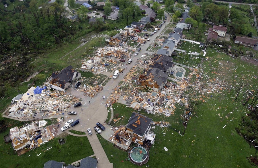
Overview: Two tornadic supercells crossed the St. Louis County Warning Area during the afternoon and evening hours of Good Friday, April 22 2011. The northern most supercell spawned a EF4 tornado that ripped a 21 mile path of destruction across St. Louis County in Missouri and Madison County in Illinois. Municipalities that were affected include Maryland Heights, Bridgeton, St. Ann, Edmundson, Lambert St. Louis International Airport (City of St. Louis), Berkeley, Ferguson, Pontoon Beach/Granite City. Remarkably, there were no fatalities with this event. This can be attributed to the 34 minutes of tornado warning lead time, wall to wall media coverage, and the actions of those in the direct path of the tornado. Five tornadoes were confirmed from this event. The northern most supercell produced three tornadoes, two of which were long-tracked. The first touchdown was near New Melle and was rated EF1, the second was the long-track tornado that was rated EF4 and affected St. Louis and Madison Counties as well as the extreme northern tip of St. Louis City, and the third was a long-track EF2 tornado that affected Madison, Clinton, and Bond Counties. The southern supercell produced two short-track tornadoes. The first was rated EF2 in Monroe County and the second was rated EF1 in St. Clair County. Click here to see the storm reports for this event (.pdf file). EF4 Tornado: St. Louis County, Missouri and Madison County, Illinois KMZ Survey File: Click Here to Download for Google Earth During the evening of Friday April 22, an intense supercell thunderstorm produced a long-track tornado which tore a path of destruction from west to east across the St. Louis Metropolitan Area. The tornado reached a maximum intensity of EF4 on the Enhanced Fujita Scale as it tracked through the community of Bridgeton, just west of Lambert St. Louis International Airport. The total path length was 22 miles, with a width of up to 0.4 miles. Amazingly, no fatalities occurred with this violent tornado and less than two dozen minor injuries were reported. There were 2700 structures damaged, including 251 homes that were heavily damaged or destroyed, and 137 commercial buildings with large or total losses. Lambert St. Louis International Airport had roughly 25 to 30 million dollars in damage from the tornado. The EF4 tornado is the strongest tornado that has occurred in St. Louis County for 44 years. You have to go back to January 24th 1967 to find a tornado that was as strong. In fact, the tornado paths are very similar. |
|||||||||||||||
|
|
|
|
|
||||||||||||
|
|
|
 |
|||||||||||||
|
The tornado initially touched down along the northern edge of Creve Coeur Lake at approximately 755 pm. It tracked nearly due east at about 40 mph, and intensified as it entered Maryland Heights. There it produced up to EF3 damage to many homes and businesses with a damage swath of 200 to 400 yards wide. Damage continued eastward in an unbroken track, crossing I-270 about 1 mile south of I-70. The tornado reached peak intensity of EF4 as it devastated the community of Bridgeton along Old St. Charles Road. From there the tornado paralleled Interstate 70 through the community of St. Ann, then took aim directly on Lambert St. Louis International Airport. Many of the large windows in the main terminal building were blown out or damaged by flying debris and a large section of roof was peeled from Concourse C. Preparedness activities and action plan procedures for the Lambert St. Louis International Airport were minimal and ineffective for this event. People in the concourses of the Lambert St. Louis International Airport did not take cover until they observed winds increasing significantly outside the concourse windows. While airport procedures were to announce warnings in the airport terminal per airport policy, each airline had its own emergency plan for the concourses; however, many airport patrons commented they received no information on the storm whether they were in the main terminal or in a concourse. Luckily only five people suffered injuries from flying debris. They were treated and released from area hospitals. The airport was closed due to the extensive damage. The tornado exited Lambert St. Louis International Airport crossing near the McDonnell Boulevard/Harmon Lane intersection. It then moved into Berkeley where it crossed Interstate 170 between Airport Road and Scudder Avenue. Extensive damage was noted along Fourth Avenue, especially at the Garfield Avenue and Hancock Avenue intersections where a vacant house and several homes lost their entire roof structure. The greatest damage in this neighborhood was rated EF2. The tornado continued to the northeast through neighborhoods south of Airport Road producing significant tree damage including many large trees falling on homes. The tornado then crossed Airport Road near Abston Avenue. The tornado crossed North Florissant Road where it caused extensive roof damage to the Newger Materials building and the First Baptist Church of Ferguson. Across the road, a Little Caesars Restaurant lost its entire roof. Damage to these structures was rated EF1. The tornado then continued through neighborhoods along and just the north of Hereford Avenue/Chambers Road where it continued to cause extensive tree damage as well as additional partial roof damage to homes along the path toward West Florissant Road. Also along this part of its path, it partially removed the roof at the Griffith Elementary School which was rated as EF1. This is also where the tornado widened to one quarter of a mile with damage noted to trees and some homes on both sides of Chambers Road. Along the entire path from Berkeley to Dellwood, damage varied in intensity from EF1 to low end EF2 with a maximum estimated wind speed of 120 mph, and included numerous snapped power poles in addition to the extensive number of snapped and downed trees. The tornadic damage continued southeast of the intersection of Chambers and Florissant Roads and traveled eastward south of Chambers road, crossing the Mississippi River approximately 2 miles south of Interstate 270. The majority of the damage was rated EF1 due to fallen trees. Some of these trees fell on homes while a few others fell through homes causing damage not directly relating to the intensity of the wind within the tornado. EF2 damage was uncovered at three different locations east of Dellwood. One area was located one quarter mile south of Chambers Road on Halls Ferry Road where four large utility poles were snapped. The second area of EF2 damage was located 0.25 mile south of Chambers Road along Bellefontaine Road where significant tree damage occurred. The last area of damage was located in Bellefontaine Neighbors just south of Chambers Road on Ra Roux Court. Roofs were removed from three homes at this location, while other homes sustained varying degrees of damage. The width of the damage area varies from 100 yards to 0.4 mile with the widest area of damage west of Halls Ferry and south of Chambers Road. The tornado entered Illinois about 1.5 miles south of the Chain of Rocks Bridge. The tornado continued east to 0.5 mile north of the intersection of Highway 203 and Pontoon Road. Damage east of this intersection included uprooted and snapped trees and three homes had roofs removed. At least one hundred homes were damaged in the area. The maximum damage found was in a neighborhood along Bern and Dawn Streets. The tornadic damage then curved southeast and ended near the intersection of Alton Street and Pontoon Road. Damage width over this area varied from 50 to 150 yards. The damage east of Highway 203 was rated low-end EF2. The highest wind speeds associated with the EF2 damage were approximately 120 mph. |
|||||||||||||||
|
EF1 Tornado: St. Charles County Near New Melle KMZ Survey File: Click Here to Download in Google Earth The tornado first touched down along Freese Lane around a tenth of a mile south of Foristell Road approximately three and a half miles to the northwest of New Melle. The tornado travelled to the east moving into the Auburn Meadows Subdivision where it caused damage to nine homes. The most significant damage occurred when one home lost almost half its roof after the attached garage was destroyed. Damage to this home was rated EF1. The rest of the homes suffered lesser degrees of roof damage. A van was also pushed approximately 30 yards from a driveway into an open grassy area. The tornado then continued to the east along Foristell Road causing damage to trees and several homes. At the Jimmie Hite Horse Stables, several large outbuildings were also heavily damaged. To the east of the stables, a horse arena was demolished. The tornado then continued to move east where it snapped or blew down many trees either side of Highway Z. The tornado continued to the east and moved into the Avondale Hills Subdivision causing minor roof damage to a few homes before lifting and dissipating just east of State Highway DD, around ½ mile north of the intersection with Schwede Road. The maximum intensity was EF1 with a maximum wind speed of 110 mph. The total path length was 7.4 miles with a maximum width 250 yards. |
|||||||||||||||
| Storm Track and Damage Photos | |||||||||||||||
|
|
|
|
|
||||||||||||
|
EF2 Tornado: Madison, Clinton, Bond Counties in Illinois The tornado first touched down 3 miles southwest of Highland just to the east of Bluemound Road around 900 pm. It quickly moved east snapping and uprooting trees. Just before reaching Illinois 160, it destroyed a large metal farm building and carried the metal panels about a mile downwind. On Old Trenton Road, it snapped three wooden power poles and snapped trees and caused minor damage to a barn roof on a farmstead. As it continued to move east it widened to 700 yards as it passed south of Highland. It caused significant damage to trees, power poles and farm outbuildings in addition to minor roof damage. Near the intersection of St. Rose Road and Iberg Road, extensive tree damage occurred with one tree falling on a home and a second falling on a prefabricated carport. The tornado continued to move east causing varying degrees of damage to five homes in a subdivision just north of St. Rose Road. The tornado then moved across waage road blowing out multiple windows of a farm house and destroying a large metal shed. The tornado continued to produce damage to farm outbuildings and minor roof damage to homes. On Keyesport Road, the tornado reached its maximum intensity between Baumann Road and Watertower Road. A farm house was destroyed when it lost its entire roof structure and the front wall partially collapsed. The rest of the farm had six buildings that were either destroyed or severely damaged. A hog farm also suffered extensive damage farther to the east on Keyesport Road. The tornado then turned east northeast and crossed into Bond County where it continued to snap and uproot trees, severely damage outbuildings and cause minor roof damage to homes before it finally dissipated around 930 pm about 7 miles south of Greenville. The maximum intensity of the tornado was rated EF2, with maximum wind speeds of 130 mph. The maximum width of the tornado was 700 yards and the total length of the tornado was 19 miles. |
|||||||||||||||
| Storm Track and Damage Photos | |||||||||||||||
|
|
|
|
|
||||||||||||
|
EF1 and EF2 Tornadoes: Monroe and St. Clair Counties in Illinois Two tornadic damage tracks were found with one in Monroe County and the second in southwest St. Clair County. The Monroe County tornado initially touched down on the north side of Waterloo Illinois near the intersection of Leah and James Streets and extended to the intersection of Konarcik and Kopp Roads over the eastern part of Monroe County Illinois. Several homes and businesses sustained varying degrees of damage; from displaced roofing materials to businesses with structural damage. Two large air conditioners were tossed 30 yards from the roof of a business. Several large trees snapped near the base of the trunk. Four power poles snapped south of the intersection of Market and Kolmer Avenue. One large garage was also destroyed behind a church with debris tossed southeastward 30 to 40 yards. The tornado skipped eastward and crossed Floraville Road on the north side of Ridge Golf and Country Club then traveled down the first fairway. A number of cedar and pine trees snapped. The tornado then crossed ridge road where several homes sustained minor roof damage, 30 to 40 percent of the shingles removed. The tornado then traveled across the northern part of Konarcik Park. Numerous old growth pine trees were snapped at the base of the trunk. Trees three feet in diameter were common in this area. The tornado caused damage to siding of one home near Konarick and Kopp Roads before lifting. The maximum intensity was low end EF2, with a maximum estimated wind speed of 115 mph. The maximum width of the tornado was 80 to 90 yards with a total path length of 3.5 miles. A second tornado initially touchdown 0. 5 mile northeast of Paderborn in southwest St. Clair County and hopped and skipped east southeastward to the Sportsman Lake Subdivision. Two power poles were snapped on knab road while six homes at the lake sustained minor roof damage in which 30 to 40 percent of the shingles were removed. A number of medium to large trees were uprooted or snapped along the damage track in this subdivision. The maximum intensity was EF1, with a maximum estimated wind speed of 100 mph. The maximum width of the tornado was 60 to 80 yards and the total path length was 1.5 miles. |
|||||||||||||||
| Storm Track and Damage Photos | |||||||||||||||
|
|
|
||||||||||||||


 Weather Story
 Weather Map
 Local Radar
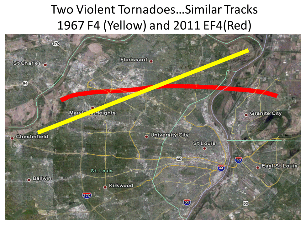