Overview
 |
During the late morning and early afternoon hours of April 27, a powerful wake low moved across the Great Lakes region, leading to a 1 to 2 hour period of damaging non-thunderstorm winds at many locations. Measured wind gusts ranged from 45 to 77 mph in the wake low across the region, with the strongest wind gust in the local area measured at 72 mph in Sandwich, IL. Sadly, there was one fatality in Grand Rapids, Michigan associated with the event.
The wake low occurred as a strong low pressure system tracked across the Midwest, spurring a severe weather outbreak that affected a large portion of the region. Thunderstorms that tracked across central Illinois and central Indiana during the early evening ended up producing a few instances of severe winds and wind damage across parts of Ford, Iroquois, and Benton counties, with stronger winds and more notable wind damage occurring south of the NWS Chicago forecast area.
Storm/Damage Reports
The damaging winds associated with the wake low started just east of the Mississippi River and expanded across a wide area through the central Great Lakes region. The peak intensity of the wake low, where wind gusts exceeded 60 mph, extended from northeastern Illinois and southwestern Wisconsin through northwestern Indiana and central Lower Michigan.
Peak Wind Gusts
 |
 |
 |
| Gray dots indicate reports of either measured wind gusts >45 mph or wind damage associated with the wake low on April 27, 2026. |
Local Wind/Damage Reports from Wake Low
..TIME...   ...EVENT...      ...CITY LOCATION...     ...LAT.LON...
..DATE...   ....MAG....      ..COUNTY LOCATION..ST.. ...SOURCE....
            ..REMARKS..

1200 PM     Non-Tstm Wnd Gst 3 W Mount Morris        42.05N 89.49W
04/27/2026  M46 MPH          Ogle               IL   Public

            Private weather station reported 46 mph gust
            west of Mount Morris.

1215 PM     Non-Tstm Wnd Gst 2 NNW Peru              41.35N 89.15W
04/27/2026  M51 MPH          La Salle           IL   AWOS

            Corrects previous non-tstm wnd gst report
            from 2 NNW Peru. Measured at KVYS.

1224 PM     Non-Tstm Wnd Gst 1 SE Winnebago          42.26N 89.23W
04/27/2026  M52 MPH          Winnebago          IL   Public

            Private weather station KILWINNE5 reported
            52 mph gust.

1244 PM     Non-Tstm Wnd Gst 3 NNE Leland            41.66N 88.78W
04/27/2026  M63 MPH          De Kalb            IL   Public

            Private weather station KILLELAN7 recorded
            63 mph gust.

1244 PM     Non-Tstm Wnd Gst 3 NW Sycamore           42.02N 88.72W
04/27/2026  M63 MPH          De Kalb            IL   Public

            Private weather station KILSYCAM31 reported
            63 mph gust.

1245 PM     Non-Tstm Wnd Gst 3 WSW Leland            41.59N 88.85W
04/27/2026  M56 MPH          La Salle           IL   Public

            Private weather station KILEARLV3 recorded
            56 mph gust.

1245 PM     Non-Tstm Wnd Gst 1 NW Cortland           41.93N 88.71W
04/27/2026  M56 MPH          De Kalb            IL   AWOS

            Dialed into KDKB AWOS. Sustained at 51 mph.
            Likely not a peak gust.

1250 PM     Non-Tstm Wnd Gst 4 NW Harvard            42.47N 88.66W
04/27/2026  M55 MPH          McHenry            IL   Mesonet

            Illinois DOT station on Lawrence Road
            northwest of Lawrence reported 55 mph gust.

1250 PM     Non-Tstm Wnd Gst 5 ENE Herbert           42.18N 88.70W
04/27/2026  M52 MPH          McHenry            IL   Public

            Illinois DOT weather station on Harmony Road
            southwest of Marengo reported 52 mph gust.

1250 PM     Non-Tstm Wnd Dmg Cortland                41.92N 88.69W
04/27/2026                   De Kalb            IL   Public

            Large tree limb snapped off of tree. Time
            estimated.

1255 PM     Non-Tstm Wnd Dmg 1 SSW Greenwood         42.38N 88.39W
04/27/2026                   McHenry            IL   Public

            Public report of large branch broken south
            of Greenwood. Little to no other damage
            noted in vicinity. Time estimated.

1255 PM     Non-Tstm Wnd Dmg 3 NNW Sandwich          41.70N 88.64W
04/27/2026                   De Kalb            IL   Emergency Mngr

            Upper portion of large tree broken, landing
            on house, near Sandwich Road and Coy Road
            north of Sandwich. Time estimated.

1255 PM     Non-Tstm Wnd Dmg Sandwich                41.65N 88.62W
04/27/2026                   De Kalb            IL   Emergency Mngr

            Large branches broken onto power lines along
            Boulevard Street in Sandwich. Time
            estimated.

0100 PM     Non-Tstm Wnd Gst 5 NNE Shabbona          41.84N 88.85W
04/27/2026  M51 MPH          De Kalb            IL   Mesonet

            Weather station at Northern Illinois
            Agronomy Research Center reported 51 mph
            gust north of Shabbona.

0103 PM     Non-Tstm Wnd Gst 2 WNW Sugar Grove       41.77N 88.48W
04/27/2026  M67 MPH          Kane               IL   ASOS

            Peak wind so far at KARR ASOS.

0103 PM     Non-Tstm Wnd Dmg 2 ESE Big Rock          41.75N 88.50W
04/27/2026                   Kane               IL   Public

            Report of multiple trees with numerous
            branches broken in the Big Rock area and
            areas southwest of Aurora Airport. Many
            branches in excess of 3 inches in diameter
            broken, at least one tree with most branches
            broken. Time estimated based upon nearby
            weather stations.

0103 PM     Non-Tstm Wnd Dmg 3 E Kaneville           41.83N 88.46W
04/27/2026                   Kane               IL   Public

            Public report of large branch or tree
            broken, blocking Green Road near IL-47. Time
            estimated.

0105 PM     Non-Tstm Wnd Dmg Aurora                  41.76N 88.32W
04/27/2026                   Kane               IL   Amateur Radio

            Large branch broken near Wilder Street and
            Park Avenue in Aurora. Time estimated by
            radar. Relayed via amateur radio.

0105 PM     Non-Tstm Wnd Gst Sandwich                41.64N 88.62W
04/27/2026  M72 MPH          De Kalb            IL   Public

            Private weather station KILSANDW45 reported
            72 mph gust.

0110 PM     Non-Tstm Wnd Gst 1 ENE Bonfield          41.15N 88.04W
04/27/2026  M47 MPH          Kankakee           IL   Public

            Private weather station near Bonfield
            reported 47 mph gust.

0110 PM     Non-Tstm Wnd Dmg St. Charles             41.91N 88.32W
04/27/2026                   Kane               IL   Public

            Large tree limb snapped off of oak tree.

0110 PM     Non-Tstm Wnd Dmg 4 NNE Campton Hills     42.00N 88.38W
04/27/2026                   Kane               IL   Public

            Siding was removed from a house as strong
            non-thunderstorm winds moved through Elgin.
            Time approximated based on nearby
            observations.

0113 PM     Non-Tstm Wnd Dmg 1 S Lake Barrington     42.19N 88.16W
04/27/2026                   Lake               IL   911 Call Center

            Multiple reports of power lines downed in
            the Lake Barrington area.

0113 PM     Non-Tstm Wnd Gst 1 SSW DuPage Airport    41.90N 88.25W
04/27/2026  M52 MPH          DuPage             IL   ASOS

            From the southeast.

0113 PM     Non-Tstm Wnd Dmg 2 WNW Warrenville       41.83N 88.21W
04/27/2026                   DuPage             IL   Emergency Mngr

            Emergency management shared a picture of an
            electrical transmission tower leaning and
            seemingly being held up by the power lines
            as a result of strong wake low winds behind
            a system of showers and thunderstorms. Time
            approximated based on nearby observations.

0115 PM     Non-Tstm Wnd Dmg 2 SE Wheaton            41.84N 88.07W
04/27/2026                   DuPage             IL   Public

            Public report of large branches broken and a
            few small trees snapped near College of
            DuPage. Time estimated.

0115 PM     Non-Tstm Wnd Dmg 1 NE Glen Ellyn         41.89N 88.04W
04/27/2026                   DuPage             IL   Local Official

            Forest Preserve District of DuPage County
            reports at least one tree snapped at
            Churchill Woods Forest Preserve. Time
            estimated.

0115 PM     Non-Tstm Wnd Gst 1 E DeKalb              41.94N 88.73W
04/27/2026  M54 MPH          De Kalb            IL   Public

            Storm chaser private weather station near
            airport in DeKalb. 54mph gust. Sustained was
            picked up at 37mph.

0120 PM     Non-Tstm Wnd Dmg 2 N Lombard             41.90N 88.01W
04/27/2026                   DuPage             IL   Local Official

            Multiple small branches broken along IL-64
            in north Lombard and north Villa Park. A few
            large limbs also broken. Relayed by Forest
            Preserve District of DuPage County. Time
            estimated.

0120 PM     Non-Tstm Wnd Dmg 1 NE Villa Park         41.89N 87.97W
04/27/2026                   DuPage             IL   Public

            Photos shared to social media show uprooted
            tree near Myrtle Street and Division Street
            in Villa Park. Time estimated.

0124 PM     Non-Tstm Wnd Gst 1 SE Wheeling           42.12N 87.91W
04/27/2026  M48 MPH          Cook               IL   ASOS


0125 PM     Non-Tstm Wnd Dmg 1 N Libertyville        42.29N 87.95W
04/27/2026                   Lake               IL   Public

            Public report of 24-inch diameter tree
            snapped near Avalon Lane and Minear Drive in
            Libertyville. Time estimated.

0127 PM     Non-Tstm Wnd Dmg 2 ESE Fox River Grove   42.19N 88.19W
04/27/2026                   Lake               IL   911 Call Center

            Tree downed onto a house.

0130 PM     Non-Tstm Wnd Dmg Wheaton                 41.87N 88.10W
04/27/2026                   DuPage             IL   Trained Spotter

            A six inch diameter tree limb had broken and
            was blocking the sidewalk near Scott St and
            Seminary Ave in Wheaton. Time estimated.

0138 PM     Non-Tstm Wnd Gst 1 ENE Bensenville       41.96N 87.92W
04/27/2026  M54 MPH          DuPage             IL   ASOS

            At KORD. From the southeast.

0140 PM     Non-Tstm Wnd Dmg 1 ENE Harwood Heights   41.97N 87.79W
04/27/2026                   Cook               IL   Public

            Multiple reports of broken tree branches in
            Norwood Park, Jefferson Park, and Portage
            Park community areas of Chicago. Relayed via
            Chicago311. Time estimated.

0142 PM     Non-Tstm Wnd Gst 1 NE Portage Park - Chi 41.96N 87.75W
04/27/2026  M50 MPH          Cook               IL   Public

            Private weather station in Mayfair area of
            Chicago reported 50 mph wind gust.

0150 PM     Non-Tstm Wnd Dmg 1 SSW Rogers Park - Chi 42.00N 87.68W
04/27/2026                   Cook               IL   Public

            Multiple reports of broken tree branches in
            Rogers Park and Edgewater community areas of
            Chicago. Relayed via Chicago311. Time
            estimated.

0150 PM     Non-Tstm Wnd Dmg 1 ENE Evanston          42.05N 87.67W
04/27/2026                   Cook               IL   Public

            Large tree limb snapped off of a tree. Time
            estimated.

0153 PM     Non-Tstm Wnd Dmg Streamwood              42.02N 88.17W
04/27/2026                   Cook               IL   911 Call Center

            Tree downed onto wires.

0156 PM     Non-Tstm Wnd Gst 4 ENE Beecher           41.37N 87.56W
04/27/2026  M50 MPH          Will               IL   Public

            Private weather station east of Beecher
            reported 50 mph gust.

0200 PM     Non-Tstm Wnd Dmg 1 NNE Cedar Lake        41.38N 87.43W
04/27/2026                   Lake               IN   Fire Dept/Rescue

            Multiple trees were reported down or snapped
            in Cedar Lake, including one large trunk
            snapped along Lakeshore Drive. Time
            estimated.

0200 PM     Non-Tstm Wnd Dmg 1 N Crown Point         41.42N 87.36W
04/27/2026                   Lake               IN   Fire Dept/Rescue

            A large tree was snapped at the base on the
            600 block of N Main St in Crown Point. Time
            estimated.

0200 PM     Non-Tstm Wnd Dmg 1 SW St. John           41.44N 87.48W
04/27/2026                   Lake               IN   Public

            A large tree was uprooted and blocking the
            road near 97th Ln and Olcott Ave in St.
            John. Time estimated.

0200 PM     Non-Tstm Wnd Dmg 3 SE Schererville       41.46N 87.40W
04/27/2026                   Lake               IN   Fire Dept/Rescue

            Numerous large trees were reported down
            around the southeast part of Schererville,
            including a couple of trees down onto homes.
            A number of power poles were downed as well.
            Time estimated.

0202 PM     Non-Tstm Wnd Gst 1 NW Cedar Lake         41.38N 87.46W
04/27/2026  M57 MPH          Lake               IN   Public


0202 PM     Non-Tstm Wnd Gst Peotone                 41.33N 87.79W
04/27/2026  M56 MPH          Will               IL   Public

            Private weather station reported 56 mph
            gust.

0208 PM     Non-Tstm Wnd Dmg St. John                41.44N 87.47W
04/27/2026                   Lake               IN   Public

            Public report of 3-foot diameter tree
            snapped, road sign bent, along 96th Lane in
            St John. Time estimated.

0210 PM     Non-Tstm Wnd Dmg 2 SSE St. John          41.42N 87.45W
04/27/2026                   Lake               IN   Public

            Multiple power poles snapped along 109th
            Avenue near Maple Lane. At least one vehicle
            struck by falling power poles. Time
            estimated.

0210 PM     Non-Tstm Wnd Dmg 2 NNE Merrillville      41.50N 87.32W
04/27/2026                   Lake               IN   Public

            Hardware store sign damaged along
            Mississippi Street in Merrillville. Shared
            via social media. Time estimated.

0212 PM     Non-Tstm Wnd Gst 4 N Lakes of the Four S 41.46N 87.21W
04/27/2026  M58 MPH          Porter             IN   Public


0212 PM     Non-Tstm Wnd Gst Northlake               41.92N 87.90W
04/27/2026  E60 MPH          Cook               IL   Public

            Estimated 60 mph gusts. Fence was blown
            down.

0213 PM     Non-Tstm Wnd Dmg 1 SW Villa Park         41.88N 87.99W
04/27/2026                   DuPage             IL   Public

            Large branches of 3 inches in diameter or
            greater downed.

0215 PM     Non-Tstm Wnd Gst Peotone                 41.33N 87.79W
04/27/2026  M56 MPH          Will               IL   Public

            Corrects previous non-tstm wnd gst report
            from Peotone.

0218 PM     Non-Tstm Wnd Gst 3 NE Navy Pier          41.92N 87.56W
04/27/2026  M49 MPH          LMZ741             IL   C-Man Station


0222 PM     Non-Tstm Wnd Gst 2 WNW South Haven       41.55N 87.17W
04/27/2026  M59 MPH          Porter             IN   Public

            A 59 mph gust was recorded at Portage High
            School.

0222 PM     Non-Tstm Wnd Dmg 2 WSW Portage           41.56N 87.20W
04/27/2026                   Porter             IN   Public

            Large tree limbs were downed near Myers
            Elementary School in Portage.

0225 PM     Non-Tstm Wnd Dmg Portage                 41.58N 87.17W
04/27/2026                   Porter             IN   Trained Spotter

            Multiple branches were reported down around
            Portage and one tree was down and blocking
            the road at Hamstrom Rd and Central Ave.

0225 PM     Non-Tstm Wnd Dmg 3 SE Schererville       41.46N 87.40W
04/27/2026                   Lake               IN   Public

            Multiple small branches broken along Burr
            Street just northwest of Crown Point.

0230 PM     Non-Tstm Wnd Dmg 1 E Valparaiso          41.47N 87.05W
04/27/2026                   Porter             IN   Public

            Large tree limbs were downed near the
            intersection of Oak and Garfield streets in
            Valparaiso. Time estimated.

0230 PM     Non-Tstm Wnd Dmg 1 W Valparaiso          41.47N 87.07W
04/27/2026                   Porter             IN   Local Official

            95 foot metal radio tower collapsed near
            Lincolnway and Yellowstone Road in
            Valparaiso. Time estimated.

0232 PM     Non-Tstm Wnd Gst Lakes of the Four Seaso 41.41N 87.22W
04/27/2026  M50 MPH          Porter             IN   Public


0240 PM     Non-Tstm Wnd Gst 3 ESE Valparaiso        41.45N 87.01W
04/27/2026  M54 MPH          Porter             IN   ASOS
|
Reports from Thunderstorms
|
The same weather system responsible for the wake low also produced a severe weather outbreak across the region. Below is a listing of storm reports from our area of responsibility that came as a result of the thunderstorms that affected the region. |
..TIME...   ...EVENT...      ...CITY LOCATION...     ...LAT.LON...
..DATE...   ....MAG....      ..COUNTY LOCATION..ST.. ...SOURCE....
            ..REMARKS..
0707 PM     Tstm Wnd Gst     1 W Gibson City         40.47N 88.40W
04/27/2026  M57 MPH          Ford               IL   Public

            Measured at an Ambient PWS.

0715 PM     Tstm Wnd Dmg     Paxton                  40.46N 88.09W
04/27/2026                   Ford               IL   Emergency Mngr

            An 8-10 inch diameter tree limb was downed
            on East Patton St between Washington and
            College streets in Paxton. Time estimated
            using radar.

0726 PM     Tstm Wnd Dmg     Buckley                 40.60N 88.04W
04/27/2026                   Iroquois           IL   Broadcast Media

            A tree was reported down onto a truck in
            Buckley. Time estimated by radar.

0730 PM     Tstm Wnd Dmg     1 SE Elliott            40.46N 88.26W
04/27/2026                   Ford               IL   Emergency Mngr

            A large tree was downed and blocking a
            driveway along IL-9 southeast of Elliott.

0730 PM     Flood            Paxton                  40.46N 88.09W
04/27/2026                   Ford               IL   Emergency Mngr

            About a half a dozen streets in Paxton were
            reported to be under 3 to 4 inches of water.

0734 PM     Tstm Wnd Gst     4 SW Crescent City      40.73N 87.91W
04/27/2026  M58 MPH          Iroquois           IL   Public

            Measured at an Ambient PWS.

0805 PM     Tstm Wnd Gst     4 WSW Fowler            40.59N 87.38W
04/27/2026  M60 MPH          Benton             IN   Public

            A 60 mph gust was recorded by a private
            weather station along US-41 southwest of
            Fowler.

0815 PM     Rain             2 E Oxford              40.52N 87.21W
04/27/2026  M2.40 Inch       Benton             IN   Public

            Private weather station KINOXFOR5 reported
            2.4 inches storm total rainfall thus far,
            with 2.36 inches over 1 hour and 15 minutes.
|
What is a Wake Low?
A Look at the Supporting Meteorology:
To understand a wake low, one must first understand the basics of a squall line.
Squall lines are often driven by a cold pool, or region of cold air, that develops at the surface as rain-cooled air from downdrafts merge. The cold pool acts like a miniature cold front that drives warm and unstable air upward at the leading edge of the squall line. This process can be self-sufficient, leading to a long-lasting thunderstorm complex that can race across large sections of the United States. Since regions of cold air are typically associated with high pressure, the leading edges of squall lines often have "meso-highs," which are small-scale regions of high pressure. (The term "mesoscale" refers to a relatively small scale in meteorology).
 |
Mature squall lines often develop a unique airstream called a rear-inflow jet (RIJ), whereby relatively dry air is pulled into the rear of the storm complex. As the stream of air accelerates toward the front of the squall line, it moves through an area called the stratiform region (the big area of rain behind the leading edge of the line of storms). Oftentimes, the rear-inflow jet begins to descend toward the ground as it approaches the leading edge of the squall line, leading to a bowing-like structure called a bow echo. The presence of a rear-inflow jet in a bow echo signals a mature squall line with a threat for widespread damaging winds.
 |
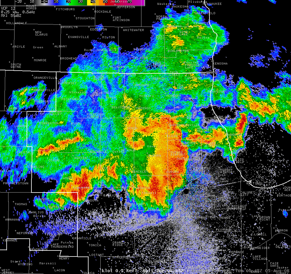 |
| Portion of Fig. 25, Johnson and Hamilton (1988) | An example of a bow echo, from 8/4/2008. |
As a squall line begins to weaken, the cooling effects of evaporation within the stratiform region cannot keep pace with the warming effects of the descending rear-inflow jet. As a result, an area of relatively warm temperatures develops on the surface along the backside of the weakening squall line, leading to a compact area of low pressure. This effect can be accelerated as the dry air within the rear-inflow jet rapidly erodes the back edge of the stratiform region of the squall line. The subsequent development of low pressure behind the squall line is called a wake low.
 |
| Source: Loehrer and Johnson (1995) |
Since air flows from regions of high to low pressure, the development of a wake low often leads to a backward oriented wind relative to the direction of travel of the squall line. In other words, wake lows will cause a wind blowing from east to west for a squall line that is moving from west to east.
While wake lows are somewhat common, they do not always produce damaging winds. Wake lows that cause damaging winds are often associated with:
The April 27, 2026 Wake Low:
During the overnight hours from April 26 to 27, a large squall line developed in Missouri and progressed eastward into central Illinois. The squall line adopted a bowing shape, indicating the development of a rear-inflow jet. With decreasing instability with eastward extent, the squall line started to weaken while crossing central Illinois. As the squall line started to decay, the rear-inflow jet started to rapidly erode the back edge of the stratiform region. The combined effects of the descending rear-inflow jet and rapid erosion of the back edge of the stratiform region of the weakening squall line lead to the development of a strong wake low.
 |
| Loop of regional radar reflectivity from roughly 12:30 to 2:15 PM CDT on April 27, 2026. Note the decaying bow-echo structure at the beginning of the loop, and the rapid drying of the back edge of the stratiform region moving across northern Illinois. Red contours indicate model-analyzed 1-hour pressure falls. Data courtesy of the College of DuPage. |
Based on the radar presentation with the stratiform region on the northern side of the eastward-moving squall line, the wake low was akin to the "asymmetric" structure proposed by Loehrer and Johnson (1995).
 |
| Portion of Fig 22., Loehrer and Johnson (1995) |
We believe there were several factors that led to the wake low on April 27 being stronger than usual.
1). There was a large pressure perturbation. According to an array of weather stations across northern Illinois during the afternoon of April 27, the wake low caused the pressure to drop 10 to 12 mb in 45 minutes. This is an extreme rate of change! For reference, only the strongest rapidly deepening low pressure systems or hurricanes generate pressure falls on the order of 4 to 6 mb in an hour.
 |
| Pressure traces from home weather stations across northern Illinois during the afternoon of April 27, 2026. Data courtesy of Weather Underground. |
2). The background flow was already blowing from southeast to northwest. The squall line that generated the wake low was located ahead of a low pressure system that was in the process of deepening just west of the Mississippi River. As a result, the prevailing wind direction outside of the squall line was already blowing from southeast to northwest toward the center of the low pressure system. Per observations from Chicago O'Hare, the wind was sustained at around 15 mph with gusts to 25 mph before the wake low arrived. Once the wake low developed, the southeasterly winds only became stronger.
 |
| A model-analyzed surface chart valid at 1:00 PM CDT 4/27/2026. The black contours are pressure, shading is dew point, dashed lines are temperature, and wind speeds are shown as barbs. Note the low pressure system in central Iowa. |
3). The air feeding the rear-inflow jet was dry. While there were no weather balloons launched near the back edge of the squall line as it moved through the Great Lakes, a forecast sounding from a high resolution model taken near a theoretical source region of the rear-inflow jet revealed a deep pocket of dry air. This dry air was effective at eroding the back edge of the stratiform region of the squall line, accelerating the development of the rear-inflow jet.
 |
| Forecast sounding taken from the 00Z run of the HRRR model, roughly 18 hours before the wake low occurred. The magenta-shaded area indicates a region of dry air that may have been the source region of the rear inflow jet in the squall line. |
For the reasons above, the wake low was able to become unusually strong and generate damaging winds between 45 and 75 mph.
Predictability
Can Wake Lows be Predicted?
Owing to inherent dependencies on how squall lines evolve, forecasting the development and intensity of wake lows can be very difficult. Oftentimes, forecast models will depict an evolution of a squall line that favors the development of a wake low, but the actual observed squall line evolves differently, leading to a false alarm.
Leading up to the April 27, 2026 wake low, high resolution forecast models provided a signal that a squall line would develop in such a way that a wake low could materialize. For example, the High Resolution Rapid Refresh (HRRR) model depicted the development and eventual decay of a bowing squall line with wake low development on the northwestern flank. The HRRR was not the only model to depict such an evolution.
 |
 |
| Simulated reflectivity from the 08Z run of the HRRR, approximately 10 hours before the event occurred in northern Illinois. Imagery courtesy of College of DuPage. | Simulated wind gusts from the 08Z run of the HRRR, approximately 10 hours before the event occurred in northern Illinois. Imagery courtesy of College of DuPage. |
Owing to the consistency in model guidance depicting the development of a wake low, forecasters at NWS Chicago became concerned that damaging winds could impact portions of the area. However, confidence in the exact evolution of the squall line was relatively low, given it was just developing near Kansas City, Missouri at the time. Such uncertainty was conveyed in the Area Forecast Discussion issued at 2:47 AM (approximately 10 hours prior to the event). In addition, forecasters created a graphic highlighting the low confidence threat for damaging winds.
 |
 |
| Simulated reflectivity from the 08Z run of the HRRR, approximately 10 hours before the event occurred in northern Illinois. | Forecast graphic sent approximately 9 hours prior to the event in northern Illinois. While the area in northern Illinois was captured well, the forecast largely missed the damaging winds that occurred in northwestern Indiana. |
As the squall line matured and entered western Illinois, it became clear that the evolution advertised by forecast models was going to play out. As a result, forecasters at NWS Chicago issued a Wind Advisory for much of the area. A portion of the Wind Advisory was later upgraded to a High Wind Warning (across northeastern Illinois).
 |
 |
| The squall line depicted in the 08Z run of the HRRR valid at 11:00 AM CDT, April 26, 2026, roughly 10 hours prior to the event. | The observed radar imagery and structure of the squall line at 11:00 AM CDT, April 26, 2026. |
 |
 |
| Map showing counties included in the Wind Advisory. Icons indicate reports of wind damage. | Map showing counties included in the High Wind Warning. Icons indicate reports of wind damage. |
Finally, can wake lows be detected in radar data in real time? While radar can often see different mechanisms to produce damaging winds in thunderstorms, the signs of damaging winds produced by wake lows in radar data are more subtle. The image below shows the NWS Chicago WSR-88D radar (KLOT) sampling winds of 60 to 75 mph as low as 1500 feet above the ground along the backside of the precipitation.
 |
| Image of 0.5 degree reflectivity (left) and velocity (right) from the NWS Chicago WSR-88D radar (KLOT) at 1:04 PM CDT, April 27, 2026. The icons indicate either measured wind gusts greater than 45 mph or reports of wind damage. The white dashed circled areas denote where the radar was sampling damaging winds. |
 |
Media use of NWS Web News Stories is encouraged! Please acknowledge the NWS as the source of any news information accessed from this site. Additional event recaps can be found on the NWS Chicago Past Events Page |
|


