New Orleans/Baton Rouge
Weather Forecast Office
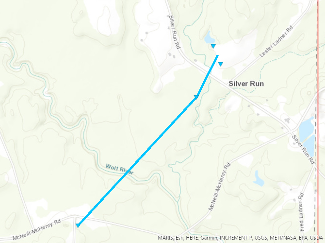
Pearl River County, MS Tornado - December 14, 2022
|
Rating:
|
EF-0
|
|
Estimated Maximum Wind:
|
75 mph
|
|
Injuries/Fatalities:
|
None
|
|
Damage Path Length:
|
1.16 miles
|
|
Maximum Path Width:
|
50 yards
|
|
Approximate Start Point/Time:
|
12 miles SSW of Texas, MS at 357 PM CST
|
|
Approximate End Point/Time:
|
11 miles SSW of Texas, MS at 358 PM CST
|
|
A National Weather Service Damage Assessment Team has surveyed the storm damage in rural eastern Pearl River County, MS. It has been determined the damage was the result of a tornado. The tornado has been rated an EF-0 on the Enhanced Fujita Scale. Damage estimates were consistent with winds of 75 mph. The tornado touched in a very rural area of eastern Pearl River County, MS damaging trees and two sheds. |
|
|
Current Hazards
Extended Outlooks
Outlooks
Fire Manager Quick Brief
Briefing Page
Storm Prediction Center
Forecasts
Marine Forecast
Activity Planner
River Forecasts
Tropical Forecast
Forecast Discussion
Aviation Weather Forecast
Graphical Forecast
Weather Models and Maps
Fire Weather Forecast
Hourly Weather Graph
Air Quality Forecasts
US Dept of Commerce
National Oceanic and Atmospheric Administration
National Weather Service
New Orleans/Baton Rouge
62300 Airport Rd.
Slidell, LA 70460-5243
504.522.7330 985.649.0429
Comments? Questions? Please Contact Us.