New Orleans/Baton Rouge
Weather Forecast Office
North Slidell, LA Tornado - April 10, 2024
|
Rating:
|
EF-1
|
|
Estimated Maximum Wind:
|
90 mph
|
|
Injuries/Fatalities:
|
None
|
|
Damage Path Length:
|
11.13 miles
|
|
Maximum Path Width:
|
250 yards
|
|
Approximate Start Point/Time:
|
2 miles N of Slidell, LA at 1003 AM CDT
|
|
Approximate End Point/Time:
|
7 miles NNW of Pearlington, MS at 1015 AM CDT
|
|
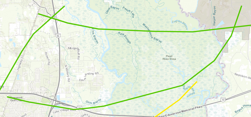
A National Weather Service Damage Assessment Team has surveyed the storm damage in Slidell, LA. It has been determined the damage was the result of a tornado. The tornado has been rated an EF-1 on the Enhanced Fujita Scale. Damage estimates were consistent with winds of 90 mph. High resolution satellite analysis, ground survey, and radar imagery aided in confirming the existence of another tornado that tracked just south of Interstate 12/10 before crossing the Interstate near Military Road and impacting the neighborhoods along Crawford Landing Road. A localized area of tree damage that aligned along eastbound Exit 83 where branches and trunks were broken or bent east distinctly separates this damage from the damage path to the north and east. This tornado damage is being used as the starting point for the tornado as it aligns with the remainder of the damage path further east. As the tornado tracked east, widespread tree damage was reported across Country Club Blvd with numerous uproots, a few snaps, and many hardwood branches broken. Damage was relatively more sporadic as the tornado crossed near the Interstate interchange until damage became more apparent along Lake Village Blvd and into Crawford Landing Road. Thereafter, the tornado damage path across the Pearl River Wildlife Management Area became increasingly more apparent as the tornado appeared to intensify on high resolution satellite imagery. The tornado damage path was its widest and most intense just west of Perch Lake where the peak width was measured to be near 250 yards. This coincided with the tornado to the south occluding and dissipating which appeared to have given it a boost. After this point, the tornado damage path began to narrow and weaken as the tornado occluded into the tornado to its north. Mostly EF0 damage points were associated with this damage path as the tornado dissipated entering the property of Stennis Space Center. |
Current Hazards
Briefing Page
Storm Prediction Center
Extended Outlooks
Outlooks
Fire Manager Quick Brief
Forecasts
Graphical Forecast
Weather Models and Maps
Fire Weather Forecast
Hourly Weather Graph
Air Quality Forecasts
Marine Forecast
Activity Planner
River Forecasts
Tropical Forecast
Forecast Discussion
Aviation Weather Forecast
US Dept of Commerce
National Oceanic and Atmospheric Administration
National Weather Service
New Orleans/Baton Rouge
62300 Airport Rd.
Slidell, LA 70460-5243
504.522.7330 985.649.0429
Comments? Questions? Please Contact Us.


