WHY: The National Weather Service office serving the New Orleans/Baton Rouge area is reconfiguring several land and marine zones in southeast Louisiana for public, marine, and fire weather products. These proposed changes to southeast Louisiana include updating the coastline to better reflect the latest land/water boundaries from the U.S. Geological Survey in the wake of Hurricane Ida. This will provide local partners and the public with more accurate forecast and weather hazard information to ensure the fulfillment of the NWS Mission. The reconfiguration also continues the ongoing effort to better target storm surge warning dissemination through the Wireless Emergency Alert system.
WHERE: After coordinating with local officials, the following parish forecast zones will be reconfigured: Jefferson, Lafourche, Plaquemines, St. Charles, and Terrebonne. This includes the creation of new marine zones for Lake Salvador and Lake Cataouatche, Terrebonne Bay, Barataria Bay, and modifies the nearshore marine waters around Plaquemines Parish.
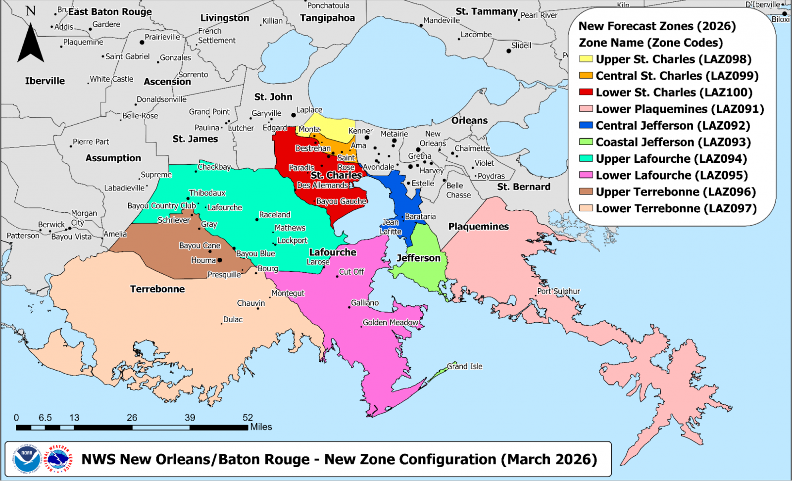
A map of the affected Parishes and Public Forecast Zones being reconfigured in March 2026.
Land-based Forecast Zones
Jefferson Parish (Louisiana): The parish is currently split into three zones and will retain three zones in the reconfiguration. The Upper Jefferson zone (LAZ087) remains unchanged. The two lower zones - Lower Jefferson (LAZ088) and Coastal Jefferson (LAZ068) - are being changed to better reflect the latest USGS land/water shapefiles, including carving out Lake Salvador and Lake Catouatche. The boundary between these two zones is also being realigned farther north to follow the coast of “The Pen” and Bayou de Fleur near Lafitte, LA. The more northern of the two zones will be renamed to Central Jefferson (LAZ092) by request of Parish officials. The more southern of the two zones will retain the name Coastal Jefferson (LAZ093).
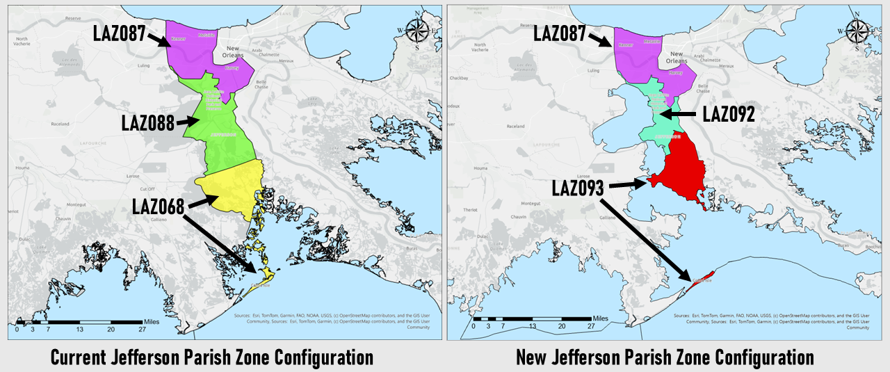
A partial list of locations included in the update Central and Coastal Jefferson Parish zones:
Central Jefferson Parish (LAZ092): Lafitte, Barataria, Jean Lafitte
Coastal Jefferson Parish (LAZ093): Grand Isle
Lafourche Parish (Louisiana): The parish is currently split into two zones and will retain two zones in the reconfiguration. The boundaries of the two zones are being changed to better reflect the latest USGS land/water shapefiles, including carving out portions of Lake Salvador and Barataria Bay, and also to align the boundary between the two zones with the Gulf Intracoastal Waterway. The northern zone will retain the name Upper Lafourche with a new zone number of LAZ094 and the southern zone will retain the name Lower Lafourche with a new zone number of LAZ095.
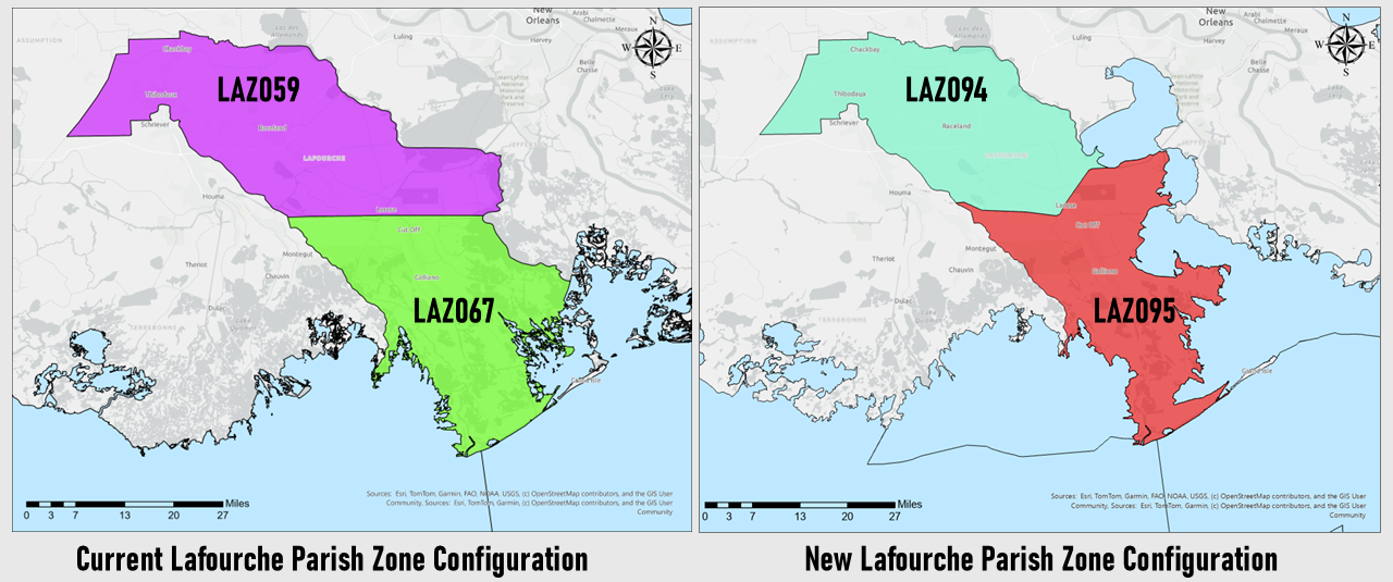
A partial list of locations included in the reconfigured Lafourche Parish zones:
Upper Lafourche Parish: Thibodaux, Raceland, Lockport
Lower Lafourche Parish: Larose, Galliano, Cut Off, Golden Meadow, Leeville
Plaquemines Parish (Louisiana): The Parish is currently divided into three zones. Upper Plaquemines (LAZ089) and Central Plaquemines (LAZ090) remain unchanged. The proposal substantially changes the coastline of Lower Plaquemines to better reflect the latest data from the USGS land/water shapefiles. Significant vertex simplification was also applied to portions of the Lower Plaquemines zone to provide a cleaner land/water border, especially near the mouth of the Mississippi River. The updated zone will be assigned zone number LAZ091.
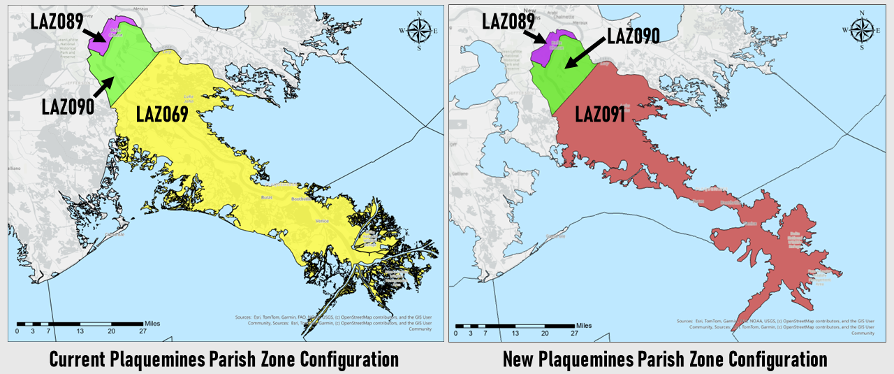
A partial list of locations included in the updated Lower Plaquemines Parish zone:
Lower Plaquemines Parish: Buras, Pointe A La Hache, Port Sulphur
St. Charles Parish (Louisiana): St. Charles Parish is currently one zone. The reconfiguration splits the parish into three zones and also carves out portions of Lakes Salvador and Cataouatche on the southeastern side of the Parish. Areas inside the HSDRRS levees will be included in a zone named Central St. Charles and assigned zone number LAZ099. Areas on the east bank of the parish and outside of the HSDRRS levees will be named Upper St. Charles and assigned the zone number LAZ098. Areas on the west bank of the parish and outside of the HSDRRS levees will be named Lower St. Charles and assigned the zone number LAZ100.
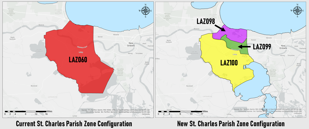
A partial list of locations included in each of the new St. Charles Parish zones:
Upper St. Charles Parish: Montz, Bonnet Carré Spillway
Central St. Charles Parish: Destrehan, Norco
Lower St. Charles Parish: Hahnville, Luling, Boutte
Terrebonne Parish (Louisiana): The parish is currently split into two zones and will retain two zones in the reconfiguration. The boundaries of the two zones are being changed to better reflect the latest USGS land/water shapefiles, and also to align the boundary between the two zones with the Gulf Intracoastal Waterway. The northern zone will retain the name Upper Terrebonne with a new zone number of LAZ096 and the southern zone will retain the name Lower Terrebonne with a new zone number of LAZ097.
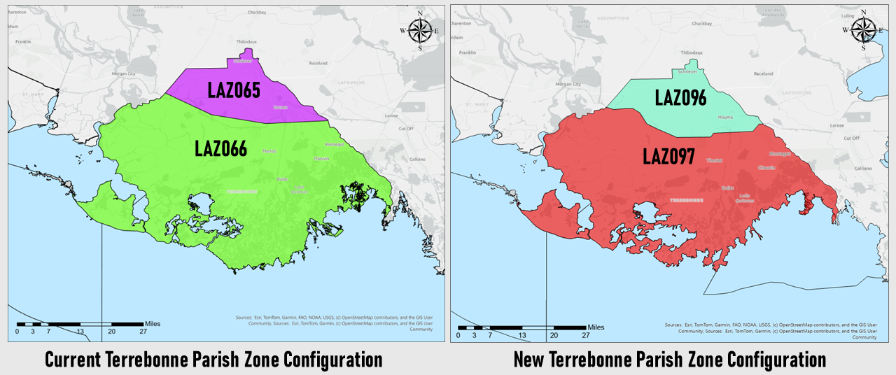
A partial list of locations included in each of the reconfigured Terrebonne Parish zones:
Upper Terrebonne Parish: Houma, Bayou Cane
Lower Terrebonne Parish: Chauvin, Cocodrie, Dulac, Montegut
Marine-based Forecast Zones
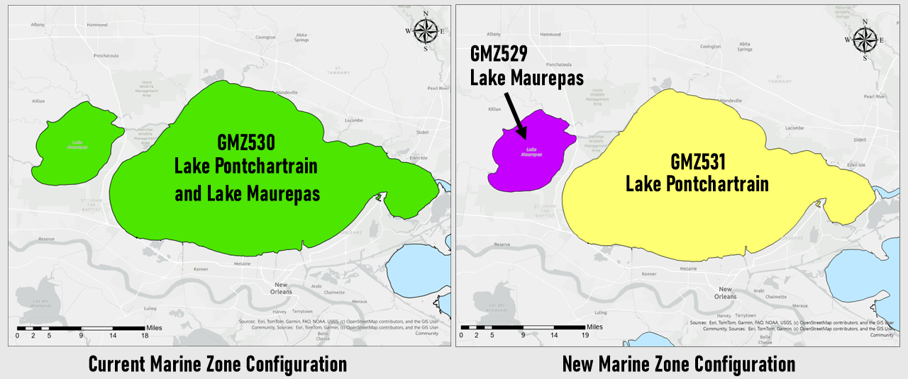
Lake Maurepas and Lake Pontchartrain: The previous zone of Lake Pontchartrain and Lake Maurepas (GMZ530) will be split into two zones - Lake Maurepas (GMZ529) and Lake Pontchartrain (GMZ531).
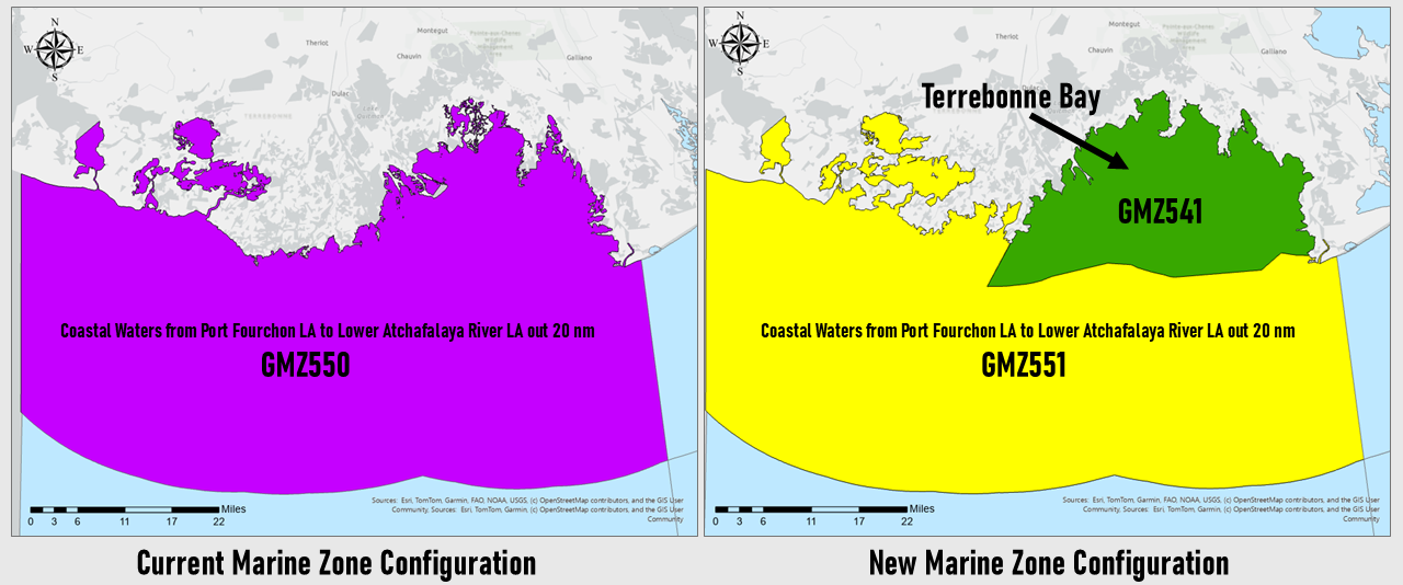
Terrebonne Bay: The previous Coastal Waters from Port Fourchon to Lower Atchafalaya River LA out 20 nm (GMZ550) will be split into two zones, roughly along a broken chain of narrow barrier islands. The open waters south of the boundary will retain the name Coastal Waters from Port Fourchon to Lower Atchafalaya River out 20 nm and will be assigned the zone number GMZ550. The more protected waters north of these islands will be named Terrebonne Bay and will be assigned zone number GMZ541. The land/water boundary of Terrebonne Bay zone will also be adjusted to better reflect the latest USGS land/water shapefiles.
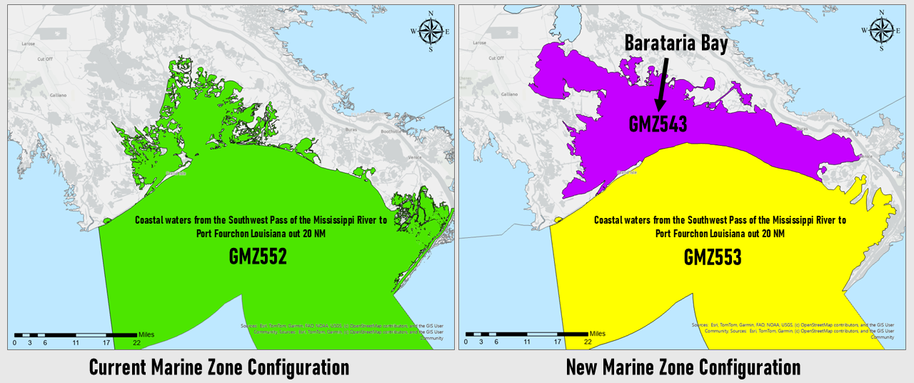
Barataria Bay: The previous Coastal Waters from Southwest Pass of the Mississippi River to Port Fourchon LA out 20 nm (GMZ552) will be split into two zones, roughly along a broken chain of mostly narrow barrier islands. The open waters south of the boundary will retain the name Coastal Waters from Southwest Pass of the Mississippi River to Port Fourchon LA out 20 nm and will be assigned the zone number GMZ553. The more protected waters north of these islands will be named Barataria Bay and will be assigned zone number GMZ543. The land/water boundary of both zones will also be adjusted to better reflect the latest USGS land/water shapefiles.
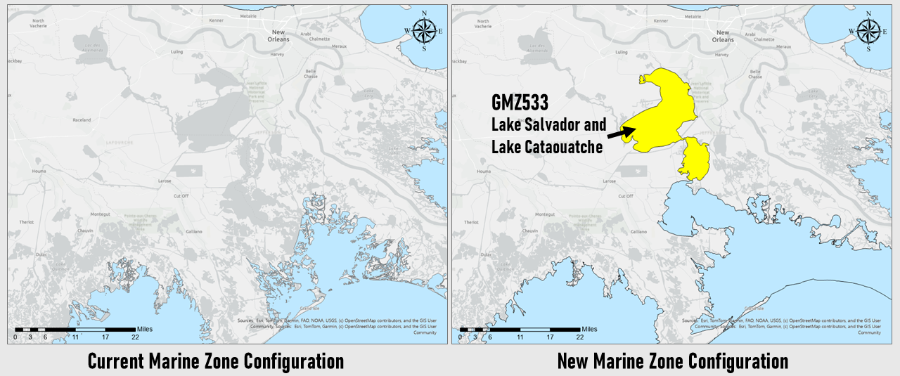
Lake Salvador and Lake Cataouatche: Lakes Salvador and Cataouatche will be a new marine zone, carved out of portions of St. Charles, Lafourche, and Jefferson Parishes. It will be assigned zone number GMZ533.
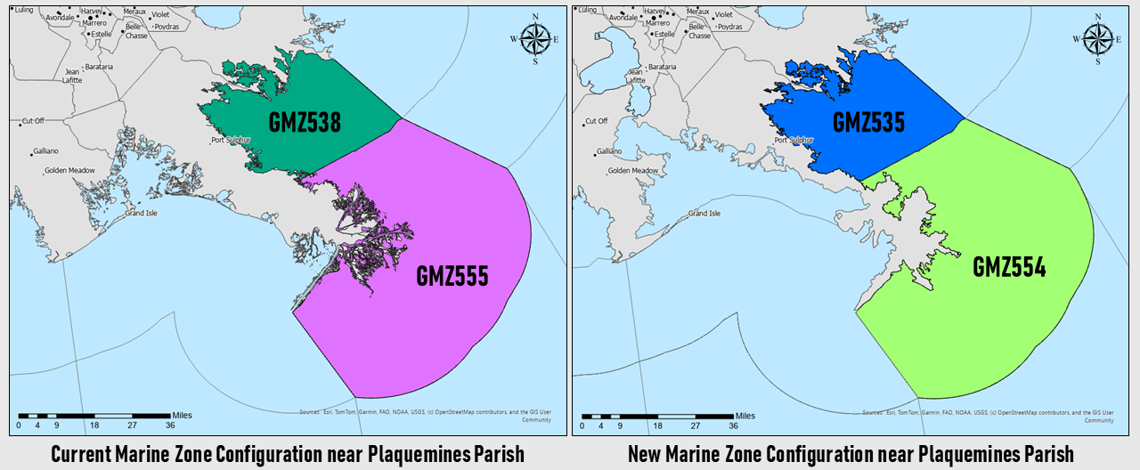
Plaquemines Parish East Bank nearshore waters: The previous marine zones Coastal Waters from Boothville to Southwest Pass of the Mississippi River LA out 20 nm (GMZ555) and Breton Sound (GMZ533) are being adjusted to better reflect the latest USGS land/water shapefiles. They will retain their names but will be assigned new zone numbers - GMZ554 and GMZ535, respectively.
WHEN: The zone implementation will occur on or near April 16, 2026.
IS THIS NORMAL? YES! The NWS frequently reconfigures forecast zones to provide better service to its partners and the public. Locally, the most recent zone reconfiguration occurred in 2023 when Hancock, Harrison, and Jackson Counties were split into two zones each to better convey storm surge threats near the coast. In general, zone reconfigurations have shown to provide increased forecast detail, especially when dealing with winter weather and tropical conditions.
Which NWS products will be affected?
The table below lists the affected land-based products by AWIPS ID and WMO Heading.
| PRODUCT NAME | WMO HEADING | AWIPS ID |
|---|---|---|
| Air Quality Alert | AEUS74 KLIX | AQALIX |
| Zone Forecast | FPUS54 KLIX | ZFPLIX |
| Point Forecast Matrices | FOUS54 KLIX | PFMLIX |
| Tabular State Forecast | FPUS64 KLIX | SFTLIX |
| Area Forecast Discussion | FXUS64 KLIX | AFDLIX |
| Special Weather Statement | WWUS84 KLIX | SPSLIX |
| Public Information Statement | NOUS44 KLIX | PNSLIX |
| Non-Precipitation Watch/Warning/Advisory | WWUS74 KLIX | NPWLIX |
| Tropical Cyclone Watch/Warning | WTNT81 KNHC | TCVAT1-5 |
| Local Tropical Watch/Warning | WTUS84 KLIX | TCVLIX |
| Hurricane Local Statement | WTUS84 KLIX | HLSLIX |
| Coastal Hazard Message | WHUS44 KLIX | CFWLIX |
| Flood Watch | WGUS64 KLIX | FFALIX |
| Hydrologic Outlook | FGUS72 KLIX | ESFLIX |
| Winter Weather Message | WWUS44 KLIX | WSWLIX |
| Fire Weather Forecast | FNUS54 KLIX | FWFLIX |
| Fire Weather Message | WWUS84 KLIX | RFWLIX |
The table below lists the affected marine-based products by AWIPS ID and WMO Heading.
| PRODUCT NAME | WMO HEADING | AWIPS ID |
|---|---|---|
| Coastal Waters Forecast | FZUS54 KLIX | CWFLIX |
| Marine Weather Message | WHUS74 KLIX | MWWLIX |
| Special Marine Warning | WHUS54 KLIX | SMWLIX |
| Marine Weather Statement | FZUS74 KLIX | MWSLIX |
| Watch County Notification | WWUS64 KLIX | WCNLIX |
| Area Forecast Discussion | FXUS64 KLIX | AFDLIX |
Do these changes affect my weather radio?
Maybe...
It will NOT affect the reception of warnings for land areas. If your NOAA Weather Radio is programmed to alert for Jefferson, Lafourche, Plaquemines, St. Charles and Terrebonne Parishes, it will continue to do so.
HOWEVER, if your radio is set up to receive warnings for any of the reconfigured marine zones, or if you want to receive warnings and forecasts for the new Lake Salvador and Lake Cataouatche marine zone, you will need to update your weather radio settings by doing the following:
Who do I contact if I have more questions?
You can send questions to sr-lix.webmaster@noaa.gov and one of our staff will get back to you.

