Hurricane Andrew
August 16-28, 1992

Above: GOES 7 Visible Satellite Image of Hurricane Andrew at 2231 UTC (5:31 PM CDT) on August 25, 1992.
Hurricane Andrew Lifecycle
Andrew's journey began as a tropical wave departing the West African coast on August 14th. By August 16th, the wave was organized enough to be classified a tropical depression, and then a tropical storm on the 17th. Andrew tracked west to northwest across the Atlantic around the south side of a ridge of high pressure. An upper low near Bermuda initially kept Tropical Storm Andrew from developing stronger as convection around the storm was sheared away from the low-level center. Eventually, the upper low weakened and retreated north while a deep ridge of high pressure over the southeastern U.S. strengthened and turned the system back to the west.
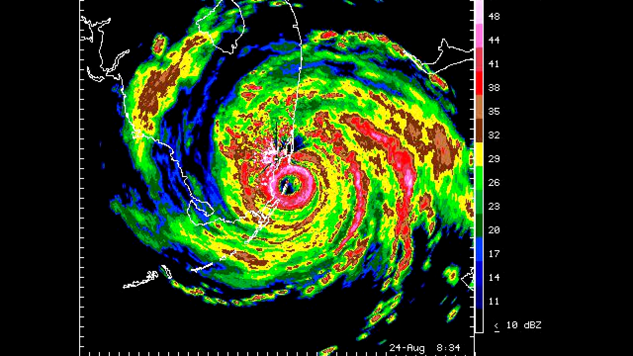
With the upper level ridge of high pressure firmly established across the Eastern United States and Western Atlantic, Andrew reached minimal hurricane intensity early on the 22nd and began to accelerate westward. During the next 36 hours, Andrew explosively intensified from a category one to a category five hurricane by mid-day on the 23rd. During this period, the central pressure dropped 72 millibars, allowing the storm to reach its maximum intensity of 175 mph (150 knots) with a minimum central pressure of 922 mb (27.23 inches). The ridge held steady over the next couple of days, driving the small but very intense hurricane west. Andrew weakened slightly to a category four hurricane while crossing the Bahamas, but re-intensified to a category five while crossing the Gulf Stream east of the Florida peninsula. The storm slammed Dade County, Florida (south of downtown Miami, near Homestead) around 5 AM EDT on August 24th with winds of 165 mph (145 knots) and a minimum central pressure of 922 millibars (27.23 inches). The Miami, FL WSR-57 radar (located on the roof of the National Hurricane Center) was destroyed shortly after the last complete scan of Hurricane Andrew at landfall. The newly installed Melbourne, FL WSR-88D captured Andrew's landfall and trek across South Florida.
Andrew weakened slightly to a category four while traversing South Florida for a few hours, eventually emerging over the Gulf. For the remainder of the 24th, Andrew continued to move quickly west-northwestward with little change in strength. By the late morning hours of the 25th, an eyewall replacement cycle completed, with a much larger eye emerging on visible satellite imagery as Andrew slowly strengthened once again. Andrew reached 145 mph (125 knots) and a minimum central pressure of 937 millibars (27.67 inches) during the late afternoon and early evening hours of the 25th, about 50 miles south of the Southeast Louisiana coast. Andrew began to slow down and move northwest for the remainder of the 25th as an approaching upper-level trough began eroding the western side of the ridge.
Hurricane Andrew continued to weaken during the early morning hours of August 26th as the eye paralleled just offshore the South-Central Louisiana coast. Andrew finally made landfall near Point Chevreuil (about 20 miles west-southwest of Morgan City) at 3:30 AM CDT as a category 3 hurricane with winds of 115 mph (100 knots) and a central pressure of 956 millibars (28.23 inches). The newly installed Houston, TX WSR-88D captured Andrew's landfall across South Central Louisiana. See the Radar and Satellite Animation Imagery section for the animation sequences of Andrew
After landfall, Andrew continued on a more northerly track while weakening across South-Central Louisiana, traversing most of the Atchafalaya Basin. Andrew was downgraded to a tropical storm by noontime, northwest of Baton Rouge, Louisiana. The storm was further downgraded to a tropical depression by midnight on the 27th, just southwest of Jackson, Mississippi. Click here for an interactive track of Hurricane Andrew.
Impacts in Southeast Louisiana and Southern Mississippi
Hurricane Andrew caused 8 deaths and an estimated $1 billion in damages in Louisiana. Combining this with Florida, Andrew directly caused 23 deaths in the U.S. and indirectly caused 39 more, with $27.3 billion in total damages. For more detailed information on the damages across Florida, Louisiana, and Mississippi, see the Storm Data Excerpt for Hurricane Andrew.
Maritime and Energy Impacts in the Gulf, Mississippi River, and Atchafalaya Basin:
240 oil and gas production platforms were damaged over an 85 mile wide area off the central and southeast Louisiana coast according to the U.S. Mineral Management Service. Estimated losses amounted to $200 million. The U.S. Coast Guard found the bodies of 6 crewmen from the fishing vessel Lucky Lee floating in the Gulf about 5 days after Andrew made landfall. The USCG rescused 4 people from the 65 foot Night Stalker that floundered in high seas and strong winds about 50 miles south of Houma around 1130 AM CDT on August 25, 1992.
Two ocean going freighters the Formosa Three and the Probo Hawk were aground near Vacherie. Two towboats, the MV Harrison and the Jolly Jack, foundered and sank near St. Francisville while attempting to retrieve breakaway barges; 10 crewmen were rescued. The Mississippi Queen steamboat evacuated 250 passengers at Baton Rouge around 10 AM CDT on August 26, 1992 because it was having difficulty remaining at its berth and due to the break away barges in the Mississippi River.
An upwelling of bottom sediment rapidly depleted oxygen in the basin and along the shallow coastal waters of Terrebonne and Lafourche Parishes. An estimated 187 million freshwater fish were killed in the Atchafalaya River basin and along Bayou Lafourche. 9 million salt water fish and a large number of oysters were killed in the shallow waters of Terrebonne and Lafourche Parishes. Total losses to the fish and wildlife industry were estimated to be $266 million.
Impacts to St. John the Baptist Parish:
A strong tornado moving rapidly west on an intermittent 9 mile path through Laplace and Reserve between 910 PM CDT and 920 PM CDT, killed two people and injured 32. Both fatalities, a 2 year old girl and a 63 year old man, occurred in their Belle Pointe subdivision homes in Reserve. A joint damage survey conducted by the St. John the Baptist Parish Office of Emergency Preparedness and the National Weather Service indicated that 66 homes and 33 mobile homes were destroyed; 56 homes or mobile homes sustained moderate damage; and 130 homes or mobile had minor damage. 25 businesses were either destroyed or sustained moderate damage. This included the River Parishes Hospital which had its roof damaged by the tornado and had to be evacuated. 7 public buildings including 2 schools were damaged. Estimated damages to homes and mobile homes were $6,726,250; businesses, $3,428,500; public buildings $1,957,500. Agricultural losses to the sugar crop were $1 million, and $100,000 to the soybean crop.

Above: Damage to homes in Laplace from an EF3 tornado that occurred as Hurricane Andrew made landfall in Louisiana.
Impacts to Lafourche Parish:
A 5.6 to 6.2 foot NGVD storm tide washed away about 500 feet of LA 1 below Leeville and about 75% of LA 3090 (Port Fourchon Road). Estimated damages to Port Fourchon including rebuilding LA 3090 were $2,200,000. Approximately 20 homes and 32 mobile homes were destroyed; 154 homes and 66 mobile homes had moderate damage; 589 homes and 68 mobile homes received minor damage. The bulk of this damage was in the south part of the parish especially in the towns of Golden Meadow, Leeville, and Port Fourchon. Nicholls State University in Thibodaux suffered a $1 million loss when strong winds damaged 28 roofs which allowed wind driven rain to soak the interior of these buildings.
Impacts to Terrebonne Parish:
A 5 to 7 foot NGVD storm tide inundated the towns of Cocodrie, Pointe Aux Chenes, Montegut, Dulac, and Chauvin. The Louisiana University Marine Consortium in Cocodrie was inundated by 5 feet of water; in addition, it sustained major wind damage when strong winds below in heavy plate glass windows. The Grand Caillou and Montegut elementary schools were flooded by storm tides. Approximately 255 homes and 547 mobile homes were destroyed; 1,726 homes and 290 mobile homes sustained moderate damage. Strong winds did an estimated $1 million damage to 201 bed L.J. Chabert Hospital in Houma when part of the roof was torn off and wind driven rain soaked the interior; 70 patients were evacuated. In addition, several businesses in Houma sustained heavy wind damage. Andrew caused an estimated $350,00 to Terrebonne Parish schools; three schools needed major roof repairs.

Above: This photo was taken in Cocodrie. Notice the steps that once provided access to the house. The combined effects of storm surge and wind pushed the home off of its foundation and into the marsh.

Above: A mobile home is destroyed by the power of Hurricane Andrew south of Dulac
Impacts to Assumption Parish:
Two homes and 4 mobile homes were destroyed; 6 homes and 20 mobile homes sustained major damage; 79 and 4 mobile homes received minor damage. The towns of Pierre Part, Napoleonville, Paincourtville, and Plattenville received the bulk of the wind damage.
Impacts to Iberville Parish:
Nine homes and 22 mobile homes were destroyed; 55 homes, 27 mobile homes, and 2 apartments sustained major damage; 313 homes, 618 mobile homes, and 7 apartments received minor damage. Most of the wind damage was concentrated in the towns of White Castle and Bayou Goula. About $100,000 damage was done to the parish public schools. The White Castle high school lost its roof. A small, brief tornado occurred in Indian Village around 242 AM CDT on August 26, 1992. Some $2.7 million in property and $10 million in crop damage occurred in this parish.
Impacts to Ascension Parish:
One home and two mobile homes were destroyed; 9 homes and 7 mobile homes received major damage; 88 homes, 10 mobile homes, and 10 apartments sustained minor damage. Most of the wind damage was concentrated in the Donaldsonville area. Louisiana Power and Light Company said strong winds toppled 11 steel electrical towers near Donaldsonville. About $5 million damage was done to the sugar cane crop and $700,000 damage was sustained by 35 businesses.
Impacts to East Baton Rouge Parish:
The National Weather Service Office at Baton Rouge measured 48 mph sustained winds with gusts of 70 mph between 11 AM and 1130 AM CDT on August 26, 1992. Eight homes, 2 mobile homes, and 13 apartments were destroyed; 62 homes, 2 mobile homes sustained major damage; 100 homes, 1 mobile home, and 4 apartments received minor damage. Most of the wind damage was concentrated in the Baton Rouge, Zachary areas. The Louisiana State University School of Music received about $50,000 in damages when it lost its roof to strong winds. Estimated property damages were about $700,000.
Impacts to West Baton Rouge Parish:
A non-National Weather Service standard anemometer at Brusly Landing measured sustained winds at 96 mph. One home and 8 mobile homes were destroyed; 12 homes, 9 mobile homes, and an apartment received major damage; 112 homes, 18 mobile homes, and 5 apartments sustained minor damage. The majority of the wind damage was in the Brusly Landing and Addis areas. A 37 year old Addis man was injured when he fell off his roof while attempting to make emergency repairs around 8 AM CDT on August 26, 1992.
Impacts to Pointe Coupee Parish:
Two homes and 8 mobile homes were destroyed; 17 homes, 10 mobile homes, and 1 apartment sustained major damage; 119 homes, 16 mobile homes, and 23 apartments received minor damage. About 300 trees and 30 power poles were blown down. Most of the wind damage was concentrated in the New Roads and Livonia areas. Fifty businesses sustained damage. A small tornado occurred in Ventress around 1027 CDT on August 26, 1992. Estimated property damage was about $5 million.
Impacts to Livingston Parish:
Two homes and 6 mobile homes were destroyed; 4 homes and 3 mobile homes sustained major damage; 9 homes and 10 mobile homes received minor damage. Most of the wind damage was concentrated in the Denham Springs area. Four schools had minor roof damage. A 34 year old Denham Springs man was electrocuted from a fallen wire while cleaning debris in his yard about 10 AM CDT August 29, 1992.
Impacts to St. Helena Parish:
One mobile home was destroyed; 3 homes and 2 mobile homes sustained major damage; 1 home received minor damage. Most of the wind damage occurred near Montpelier. About $3 million damage was done to timber.
Impacts to St. Tammany Parish:
Two homes were destroyed; 7 homes and 1 mobile home sustained major damage; 10 homes received minor damage. Two fast-moving small tornadoes were spawned by Hurricane Andrew. The first tornado damaged several homes along an intermittent path that began 5 miles north of Lacombe and ended 4 miles north of Covington between 925 AM and 945 AM CDT on August 26, 1992. The second tornado took off the roofs of several homes near Mandeville around 330 PM CDT. There was some storm tide flooding in Mandeville and Slidell. Several businesses near the Mandeville lakefront were flooded with up to 1.5 feet of water; in addition, the Mandeville seawall was damaged by high waves. A few homes in the Palm Lake subdivision in south Slidell had some minor flood damage. A barge broke free from its moorings on the Tchefuncte River and was lodged against the Tchefuncte River draw bridge in Madisonville; fortunately, the bridge received only minor damage. Some $1 million in property damage occurred in this parish.
Impacts to Tangipahoa Parish:
Two mobile homes were destroyed, and three homes suffered major damage. The Tangipahoa Sheriff's Office reported a small, fast moving tornado was responsible for some of this damage along an intermittent path from Tickfaw to Loranger around 715 CDT on August 26, 1992. In addition, some 300 trees were blown down. Two people were injured when they drove into a large fallen tree in Hammond. A cafe lost its roof and a car wash was destroyed in Ponchatoula. Strong winds blew down a radio tower near Independence. Only a few homes were flooded even though 10 to 11 inches of rain were reported in Hammond, Robert, and Amite.
Impacts to Plaquemines Parish:
The National Weather Service automated C-MAN station at the Southwest Pass of the Mississippi River recorded sustained winds of 67 mph with gusts of 77 mph around 5 PM CDT on August 25, 1992. One home was destroyed; 6 homes and 1 mobile home sustained major damage; 2 mobile homes received minor damage. A 62 year old man was killed in his vehicle near Empire while evacuating during the afternoon of August 24, 1992 and 2 other people were injured in the accident.
Impacts to St. Bernard Parish:
One home and mobile home was destroyed; 1 home and 3 mobile homes sustained major damage; 4 homes and 1 mobile home received minor damage due to strong winds. A 6 foot NGVD storm tide flooded roads outside of the federal hurricane protection levee.
Impacts to Jefferson Parish:
One home and 23 mobile homes were destroyed; 3 homes and 5 mobile homes sustained major damage; 17 homes and 8 mobile received minor damage. Most of this damage was confined to Grand Isle where the National Weather Service automated C-MAN station recorded sustained winds of 58 mph and gusts to 77 mph at 5 PM CDT on August 25, 1992.
Impacts to St. Charles Parish:
Five homes sustained major damage; 35 homes and 5 mobile received minor damage. Most of the wind damage was concentrated in the Luling and Hahnville areas.
Impacts to Walthall and Pike Counties:
Scattered trees were blown down throughout both counties.
| Additional Data, Maps, Tables | |||||
| Wind and Pressure | Storm Surge | Rainfall | Tornadoes | ||
| Other Post Storm Reports | |||
| Monthly Weather Review - 1992 Atlantic Hurricane Season | |||
| National Hurricane Center | Hurricane Research Division | Storm Data | |
| Lake Charles, LA | Baton Rouge, LA | New Orleans, LA | |
|
Radar and Satellite Animated Imagery |
||||||||||||
|
||||||||||||
| News | ||||
| ABC News August 26, 1992: Hurricane Andrew hits Louisiana |

