New Orleans/Baton Rouge
Weather Forecast Office
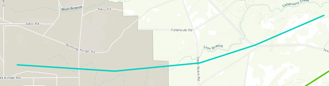
Stennis Space Center, MS Tornado - April 10, 2024
|
Rating:
|
EF-0
|
|
Estimated Maximum Wind:
|
85 mph
|
|
Injuries/Fatalities:
|
None
|
|
Damage Path Length:
|
5.33 miles
|
|
Maximum Path Width:
|
300 yards
|
|
Approximate Start Point/Time:
|
9 miles ENE of Pearl River, LA at 1017 AM CDT
|
|
Approximate End Point/Time:
|
5 miles WSW of Kiln, MS at 1024 AM CDT
|
|
A National Weather Service Damage Assessment Team has surveyed the storm damage in Stennis Space Center, MS. It has been determined the damage was the result of a tornado. The tornado has been rated an EF-0 on the Enhanced Fujita Scale. Damage estimates were consistent with winds of 85 mph. This tornado started fairly large from the start with a swath extending from Leonard Kimble Road and further north along Mainline Road. High resolution satellite imagery indicated the damage path continued eastward where it crossed Texas Flat Road. Branches were broken and a few snapped trees were observed in a generally confluent pattern. The end point for this tornado is estimated based off high resolution satellite NDVI differencing as it interactive with the parent mesovortex and appeared to dissipate. |
|
|
Current Hazards
Outlooks
Fire Manager Quick Brief
Briefing Page
Storm Prediction Center
Extended Outlooks
Forecasts
Tropical Forecast
Forecast Discussion
Aviation Weather Forecast
Graphical Forecast
Weather Models and Maps
Fire Weather Forecast
Hourly Weather Graph
Air Quality Forecasts
Marine Forecast
Activity Planner
River Forecasts
US Dept of Commerce
National Oceanic and Atmospheric Administration
National Weather Service
New Orleans/Baton Rouge
62300 Airport Rd.
Slidell, LA 70460-5243
504.522.7330 985.649.0429
Comments? Questions? Please Contact Us.