National Weather Service United States Department of Commerce

Severe Weather Across the Ohio Valley and into the Mid Atlantic; Prolonged Heat in the Southern Plains

Scattered damaging winds and a couple tornadoes are possible on Saturday from parts of Ohio into northern West Virginia/Maryland, central and western Pennsylvania, and western New York. The thunderstorm threat will move into the Northeast on Sunday. Prolonged heat will continue across the Southern Plains this weekend and into next week. Read More >

Summer 2023 - Rolling Climatology & Statistics

Page will be updated as new climate data becomes available


Jump to:


August 2023

Month and Year To Date (YTD) Temperature and Precipitation Statistics:


New Orleans International Airport [KMSY] -  (August CLM text product)

Non-Threaded POR [Period of record]: 1946-05-01 - YTD. Climate normal period 1991 to 2020.

Hot Points:

  • New Orleans International (KMSY) broke the all-time warmest temperature on record of 105ºF on August 27th, breaking the previous of 102ºF, reached earlier in the month on Aug 26th and Aug 23rd (which these tied the previous all-time record of 102 set in 1980)
  • New Orleans International (KMSY) ranked the top warmest mean average and max average temperature for the month of August.
  • New Orleans International (KMSY) broke the record for greatest total number of 100ºF days in the month of August at 15 (previous 2 in August 2011)

  • New Orleans International (KMSY) tied or broke record highs 20/31 days (65%) of the month of August. 29/31 days (94%) above average highs, 27/31 (87%) night time lows above average. 

  • New Orleans International (KMSY) ended the month at a 23.78" deficit below average precipitation for the year. August total precipitation of 2.97" ranks the 13th driest August on record (Avg: 6.91")


Maximum 1-Month Mean Max Temperature:

  • 98.2ºF (Rank top warmest) - Previous warmest: 95.9ºF August 2011

Maximum 1-Month Mean Average Temperature:

  • 89.1ºF (Rank top warmest) - Previous warmest: 87.3ºF August 2011


2023 Monthly Mean Max Summary:

(filtered to remove >15 missing days)

05-01 to 05-31 Average Max Temp: 86.4ºF Rank: 19th warmest

06-01 to 06-30 Average Max Temp: 93.7ºF Rank: 2nd warmest

07-01 to 07-31 Average Max Temp: 95.5ºF Rank: Top warmest

08-01 to 08-31 Average Max Temp: 98.2ºF Rank: Top warmest

09-01 to 09-30


2023 Monthly Average Summary:

(filtered to remove >15 missing days)

05-01 to 05-31 Average Temp: 78.5F Rank: 9th warmest

06-01 to 06-30 Average Temp: 84.8F Rank: 3rd warmest

07-01 to 07-31 Average Temp: 86.7F Rank: Tied warmest

08-01 to 08-31 Average Temp: 89.1ºF Rank: Top Warmest

09-01 to 09-30


2023 Total Moving Mean Average Summary:

(filtered to remove >15 missing days)

01-01 to 05-31 Average Temp: 68.5F Rank: 3rd warmest

01-01 to 06-30 Average Temp: 71.2F Rank: 3rd warmest

01-01 to 07-31 Average Temp: 73.4ºF Rank: 2nd warmest

01-01 to 08-31 Average Temp: 75.4ºF Rank: Top Warmest

01-01 to 09-30


Baton Rouge [KBTR] -  (August CLM text product)

Threaded POR [Period of record]: 1892-06-01 - YTD. Climate normal period 1991 to 2020.

Hot Points:

  • Baton Rouge Airport (KBTR) shattered the record for the warmest August on record with a mean high temperature of 101.5ºF (+9.19ºF departure from the normal August average of 92.2ºF). The August mean high temperature  of 101.5ºF surpassed the previous August record of 98.1ºF set in 1921 by a staggering 3.4ºF). 
  • Baton Rouge Airport (KBTR) had high temperatures 100ºF a total of 24 days in the month of August, 31/31 (100%) of days above average highs, 16/31 (52%) days with tied or record high temperatures.
  • KBTR broke the record of longest consecutive days of highs 100ºF at 10 (8/10-8/27) and for highs 101ºF at 10 (8/18-8/27)
  • The average max heat index for the month of August was 111ºF, with the highest heat index of 119 on Sunday, August 20th.
  • KBTR had a total of 15 days with lows at or above 80F, with the all-time warmest low of 85 set on Thursday, August 10th.


Maximum 1-Month Mean Max Temperature:

  • 101.5ºF (Rank top warmest) - Previous warmest: 98.1ºF August 1921.

Maximum 1-Month Mean Average Temperature:

  • 90.1ºF (Rank top warmest) - Previous warmest: 86.3ºF August 2011.


2023 Monthly Mean Max Summary:

(filtered to remove >15 missing days)

05-01 to 05-31 Average Max Temp: 88.4ºF Rank: 14th warmest

06-01 to 06-30 Average Max Temp: 94.9ºF Rank: Tied warmest

07-01 to 07-31 Average Max Temp: 97.8ºF Rank: Top warmest

08-01 to 08-31 Average Max Temp: 101.5ºF Rank: Top warmest

09-01 to 09-30


2023 Monthly Average Summary:

(filtered to remove >15 missing days)

05-01 to 05-31 Average Temp: 78.0F Rank: 9th warmest

06-01 to 06-30 Average Temp: 84.5F Rank: Top warmest

07-01 to 07-31 Average Temp: 87.8ºF Rank: Top warmest

08-01 to 08-31 Average Temp: 90.1ºF Rank: Top warmest

09-01 to 09-30


2023 Total Moving Mean Average Summary:

(filtered to remove >15 missing days)

01-01 to 05-31 Average Temp: 67.3F Rank: 2nd warmest

01-01 to 06-30 Average Temp: 70.1F Rank: 2nd warmest

01-01 to 07-31 Average Temp: 72.7ºF Rank: Top warmest

01-01 to 08-31 Average Temp: 74.9ºF Rank: Top warmest

01-01 to 09-30


Gulfport [KGPT] (August CLM text product)

Non-Threaded POR [Period of record]: 1893-06-01 - YTD

Hot Points:

  • Gulfport (KGPT) reached the top warmest average max temperature in the month of August at 97.9ºF.
  • KGPT had lows at or above 80ºF for 15 days in the month of August, with the warmest low of 85 on Thursday, August 10th. 15/31 (48.4%) of the mornings broke or tied record warm lows.
  • The average max heat index for the month of August was 112ºF, with the highest heat index of 120ºF on Thursday, August 10th.
  • Gulfport (KGPT) ended the month at a 21.74" deficit below average precipitation for the year. August total precipitation of 0.62" ranks the 2nd driest August on record, right below the driest August set in 1954 (0.35"), Avg: 6.53".


Maximum 1-Month Mean Max Temperature:

  • 97.9ºF  (Rank top warmest) - Previous warmest: 95.4ºF August 2011.

Maximum 1-Month Mean Average Temperature:

  • 88.6ºF (Rank top warmest) - Previous warmest: 86.5ºF August 2010.


2023 Monthly Mean Max Summary:

(filtered to remove >15 missing days)

05-01 to 05-31 Average Max Temp: 85.4ºF Rank: 20th warmest

06-01 to 06-30 Average Max Temp: 92.1ºF Rank: 12th warmest

07-01 to 07-31 Average Max Temp: 94.6ºF Rank: 3rd warmest

08-01 to 08-31 Average Max Temp: 97.9ºF Rank: Top warmest

09-01 to 09-30


2023 Monthly Average Summary:

(filtered to remove >15 missing days)

05-01 to 05-31 Average Temp: 76.6F Rank: 26th warmest

06-01 to 06-30 Average Temp: 83.2F Rank: 10th warmest

07-01 to 07-31 Average Temp: 85.7ºF Rank: 2nd warmest

08-01 to 08-31 Average Temp: 88.6ºF Rank: Top warmest

09-01 to 09-30


2023 Total Moving Mean Average Summary:

(filtered to remove >15 missing days)

01-01 to 05-31 Average Temp: 66.4F Rank: 2nd warmest

01-01 to 06-30 Average Temp: 69.2F Rank: Top warmest

01-01 to 07-31 Average Temp: 71.6ºF Rank: Top Warmest

01-01 to 08-31 Average Temp: 73.8ºF Rank: Top Warmest

01-01 to 09-30


July 2023

Month and Year To Date (YTD) Temperature and Precipitation Statistics:


New Orleans International Airport [KMSY] -  (July CLM text product)

Non-Threaded POR [Period of record]: 1946-05-01 - YTD. Climate normal period 1991 to 2020.

Hot Points:

  • New Orleans International (KMSY) tied for the warmest July on record at 86.7ºF. This ties July 2016. Also, July 2023 was the 2nd warmest overall month on recorded behind August 2011 at 87.3ºF.
  • New Orleans International (KMSY) high of 101F on July 31st was the warmest day in July on record. 
  • New Orleans International (KMSY): 6th driest July on record (3.31"/Avg: 6.79")


Maximum 1-Month Mean Max Temperature:

  • 95.5ºF (Rank top warmest) - Previous warmest: 94.9ºF July 1980.

Maximum 1-Month Mean Average Temperature:

  • 86.7ºF (Tied warmest) - Tied warmest: 86.7ºF July 2016.


2023 Monthly Mean Max Summary:

(filtered to remove >15 missing days)

05-01 to 05-31 Average Max Temp: 86.4ºF Rank: 19th warmest

06-01 to 06-30 Average Max Temp: 93.7ºF Rank: 2nd warmest

07-01 to 07-31 Average Max Temp: 95.5ºF Rank: Top warmest

08-01 to 08-31 

09-01 to 09-30


2023 Monthly Average Summary:

(filtered to remove >15 missing days)

05-01 to 05-31 Average Temp: 78.5F Rank: 9th warmest

06-01 to 06-30 Average Temp: 84.8F Rank: 3rd warmest

07-01 to 07-31 Average Temp: 86.7F Rank: Tied warmest

08-01 to 08-31

09-01 to 09-30


2023 Total Moving Mean Average Summary:

(filtered to remove >15 missing days)

01-01 to 05-31 Average Temp: 68.5F Rank: 3rd warmest

01-01 to 06-30 Average Temp: 71.2F Rank: 3rd warmest

01-01 to 07-31 Average Temp: 73.4ºF Rank: 2nd warmest

01-01 to 08-31

01-01 to 09-30


Baton Rouge [KBTR] -  (July CLM text product)

Threaded POR [Period of record]: 1892-06-01 - YTD. Climate normal period 1991 to 2020.

Hot Points:

  • Baton Rouge Airport (KBTR) shattered the record for the warmest July on record 87.8ºF (surpassing the previous July record of 85.6ºF set in 1960 by a staggering 2.2ºF). This also is the total warmest month on record, with the previous being August 2011 at 86.3ºF.
  • KBTR has had a low of 80ºF or above a total of 8 times in the month of July, bringing the total to 12 for 2023. In the month of July, 3 of those days (7-2, 7-14, 7-21) were 81ºF and 1 (7-13) reached 82ºF. This year (so far in 2023) breaks the record for the most frequent minimum temperatures of 80ºF or above at 12 for KBTR, breaking the previous of 4 in in 2019.
  • Baton Rouge Airport (KBTR): 7th driest July on record (2.21"/Avg: 5.09").


Maximum 1-Month Mean Max Temperature:

  • 97.8ºF (Rank top warmest) - Previous warmest: 96.4ºF July 1960.

Maximum 1-Month Mean Average Temperature:

  • 87.8ºF (Rank top warmest) - Previous Warmest: 85.6ºF July 1960.


2023 Monthly Mean Max Summary:

(filtered to remove >15 missing days)

05-01 to 05-31 Average Max Temp: 88.4ºF Rank: 14th warmest

06-01 to 06-30 Average Max Temp: 94.9ºF Rank: Tied warmest

07-01 to 07-31 Average Max Temp: 97.8ºF Rank: Top warmest

08-01 to 08-31

09-01 to 09-30


2023 Monthly Average Summary:

(filtered to remove >15 missing days)

05-01 to 05-31 Average Temp: 78.0F Rank: 9th warmest

06-01 to 06-30 Average Temp: 84.5F Rank: Top warmest

07-01 to 07-31 Average Temp: 87.8ºF Rank: Top warmest

08-01 to 08-31

09-01 to 09-30


2023 Total Moving Mean Average Summary:

(filtered to remove >15 missing days)

01-01 to 05-31 Average Temp: 67.3F Rank: 2nd warmest

01-01 to 06-30 Average Temp: 70.1F Rank: 2nd warmest

01-01 to 07-31 Average Temp: 72.7ºF Rank: Top warmest

01-01 to 08-31

01-01 to 09-30


Gulfport [KGPT] (July CLM text product)

Non-Threaded POR [Period of record]: 1893-06-01 - YTD

Hot Points:

  • Gulfport (KGPT) reached the second warmest July on record at 85.7ºF, with the previous July record being 86.1ºF in 2010.


Maximum 1-Month Mean Max Temperature:

  • 94.6ºF (Rank 3rd warmest) - Warmest: 94.8ºF July 1980.

Maximum 1-Month Mean Average Temperature:

  • 85.7ºF (Rank 2nd warmest) - Warmest: 86.1ºF July 2010.


2023 Monthly Mean Max Summary:

(filtered to remove >15 missing days)

05-01 to 05-31 Average Max Temp: 85.4ºF Rank: 20th warmest

06-01 to 06-30 Average Max Temp: 92.1ºF Rank: 12th warmest

07-01 to 07-31 Average Max Temp: 94.6ºF Rank: 3rd warmest

08-01 to 08-31

09-01 to 09-30


2023 Monthly Average Summary:

(filtered to remove >15 missing days)

05-01 to 05-31 Average Temp: 76.6F Rank: 26th warmest

06-01 to 06-30 Average Temp: 83.2F Rank: 10th warmest

07-01 to 07-31 Average Temp: 85.7ºF Rank: 2nd warmest

08-01 to 08-31

09-01 to 09-30


2023 Total Moving Mean Average Summary:

(filtered to remove >15 missing days)

01-01 to 05-31 Average Temp: 66.4F Rank: 2nd warmest

01-01 to 06-30 Average Temp: 69.2F Rank: Top warmest

01-01 to 07-31 Average Temp: 71.6ºF Rank: Top Warmest

01-01 to 08-31

01-01 to 09-30


June 2023

Month and Year To Date (YTD) Temperature and Precipitation Statistics:


New Orleans International Airport [KMSY] -  (June CLM text product)

Non-Threaded POR [Period of record]: 1946-05-01 - YTD. Climate normal period 1991 to 2020.

Hot Points:

  • New Orleans (KMSY): 5th driest June on record (1.54"/Avg: 7.62")


Maximum 1-Month Mean Max Temperature:

  • 93.7ºF (2nd warmest) - Top warmest: 94.1ºF in June 2011.

Maximum 1-Month Mean Average Temperature:

  • 84.8ºF (3rd warmest) - Top warmest: 85.1ºF June 2022.


2023 Monthly Mean Max Summary:

(filtered to remove >15 missing days)

05-01 to 05-31 Average Max Temp: 86.4ºF Rank: 19th warmest

06-01 to 06-30 Average Max Temp: 93.7ºF Rank: 2nd warmest

07-01 to 07-31 

08-01 to 08-31 

09-01 to 09-30


2023 Monthly Average Summary:

(filtered to remove >15 missing days)

05-01 to 05-31 Average Temp: 78.5F Rank: 9th warmest

06-01 to 06-30 Average Temp: 84.8F Rank: 3rd warmest

07-01 to 07-31

08-01 to 08-31

09-01 to 09-30


2023 Total Moving Mean Average Summary:

(filtered to remove >15 missing days)

01-01 to 05-31 Average Temp: 68.5F Rank: 3rd warmest

01-01 to 06-30 Average Temp: 71.2F Rank: 3rd warmest

01-01 to 07-31

01-01 to 08-31

01-01 to 09-30


Baton Rouge [KBTR] -  (June CLM text product)

Threaded POR [Period of record]: 1892-06-01 - YTD. Climate normal period 1991 to 2020.

Hot Points:

  • Baton Rouge Airport [KBTR] broke the record for the warmest average temperature in the month of June at 84.5ºF.
  • Friday, June 30th was the first time Baton Rouge [KBTR] surpassed a high of 100ºF (actual high 101ºF) since August 10th, 2015 (2,881 days)


Maximum 1-Month Mean Max Temperature:

  • 94.9ºF (Tied warmest) -Top warmest: 94.9ºF June 2011.

Maximum 1-Month Mean Average Temperature:

  • 84.5ºF (Top warmest) - Previous warmest: 83.9ºF June 2022.


2023 Monthly Mean Max Summary:

(filtered to remove >15 missing days)

05-01 to 05-31 Average Max Temp: 88.4ºF Rank: 14th warmest

06-01 to 06-30 Average Max Temp: 94.9ºF Rank: Tied warmest

07-01 to 07-31

08-01 to 08-31

09-01 to 09-30


2023 Monthly Average Summary:

(filtered to remove >15 missing days)

05-01 to 05-31 Average Temp: 78.0F Rank: 9th warmest

06-01 to 06-30 Average Temp: 84.5F Rank: Top warmest

07-01 to 07-31 

08-01 to 08-31

09-01 to 09-30


2023 Total Moving Mean Average Summary:

(filtered to remove >15 missing days)

01-01 to 05-31 Average Temp: 67.3F Rank: 2nd warmest

01-01 to 06-30 Average Temp: 70.1F Rank: 2nd warmest

01-01 to 07-31 

01-01 to 08-31

01-01 to 09-30


Gulfport [KGPT] -  (June CLM text product)

Non-Threaded POR [Period of record]: 1893-06-01 - YTD

Hot Points:

  •  

Maximum 1-Month Mean Max Temperature:

  • 92.1ºF (Rank 12th warmest) - Warmest: 93.4ºF June 1982.

Maximum 1-Month Mean Average Temperature:

  • 83.2ºF (Rank 10nd warmest) - Warmest: 84.8ºF June 2010.


2023 Monthly Mean Max Summary:

(filtered to remove >15 missing days)

05-01 to 05-31 Average Max Temp: 85.4ºF Rank: 20th warmest

06-01 to 06-30 Average Max Temp: 92.1ºF Rank: 12th warmest

07-01 to 07-31 

08-01 to 08-31

09-01 to 09-30


2023 Monthly Average Summary:

(filtered to remove >15 missing days)

05-01 to 05-31 Average Temp: 76.6F Rank: 26th warmest

06-01 to 06-30 Average Temp: 83.2F Rank: 10th warmest

07-01 to 07-31 

08-01 to 08-31

09-01 to 09-30


2023 Total Moving Mean Average Summary:

(filtered to remove >15 missing days)

01-01 to 05-31 Average Temp: 66.4F Rank: 2nd warmest

01-01 to 06-30 Average Temp: 69.2F Rank: Top warmest

01-01 to 07-31

01-01 to 08-31

01-01 to 09-30


WFO LIX Heat Hazard Product Statistics:

Updated 8/7/23


Heat Hazard Product Hot Points (Last Updated August 3rd):​​

  • This year [2023] was the first time we've issued an Excessive Heat Watch (EH.A) in the month of June [6/24].
  • This year [2023] breaks the record for the most amount of Excessive Heat Warnings (EH.W) at 12 (as of 8/2) breaking the previous record of 5 issued in 2010.
  • This year [2023] breaks the record for the most consecutive days under an Excessive Heat Warning at 5 [06-27 - 07-01].
  • As of 8/7, WFO LIX has issued a total of 26 Heat Advisories, the 2nd most issued in a single year (record is 27 in 2021) and topped the most Heat Advisories issued in the month of July at 15. Disclaimer: the local criteria issuance did change in 2015.


Disclaimer: Hazard (VTEC) product statistics do not reflect any local history of criteria changes over the years and date ranges only span the limit available via Iowa State University IEM database. Climate data analysis and interpretation is subject to errors. Email sr-lix.webmaster@noaa.gov if you notice any errors or have any questions.


Excessive Heat Warning [Hazard Product EH.W] Stats:

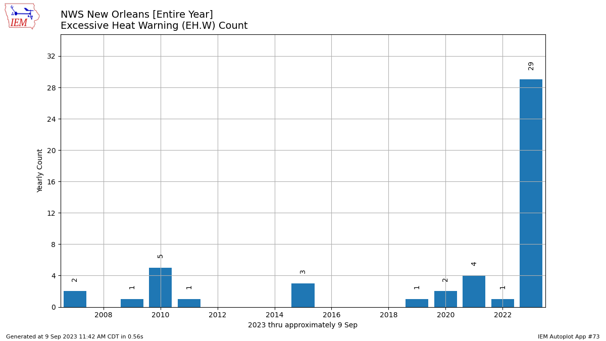
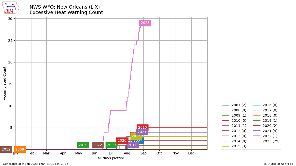
As of 9/9/23: WFO LIX has issued an EH.W 29 times, compared to the 2007-2022 average of generally 1.3 pear year.


Top 3 Earliest in the year issuance of Excessive Heat Warnings [EH.W]:


Earliest: 6/16/2023: (061623_0846Z)

2nd Earliest: 06/23/2022: (062322_1818Z)

3rd Earliest: 06/24/2009: (062409_1436Z)


Top 3 Greatest total number of Excessive Heat Warnings [EH.W] issued in a single year:


(29 days*) 2023: [06-16, 06-17, 06-18, 06-19, 06-27, 06-28, 06-29, 06-30, 07-01, 07-31, 08-01, 08-02, 08-04, 08-05, 08-06, 08-07, 08-08, 08-09, 08-10, 08-11, 08-12, 08-13, 08-14, 08-15, 08-19, 08-23, 08-24, 08-26, 08-27]

(5 days) 2010: [08-01, 08-02, 08-04, 08-08, 08-22]

(4 days) 2021: [7-30, 7-31, 7-31, 8-21]

*With 19 out of 29 EH.W days in 2023 being in the month of August.


Top 3 consecutive days of Excessive Heat Warnings [EH.W] issued in a single year:


(5 days) 2023: [08-04 thru 08-15]

(5 days) 2023: [06-27 thru 07-01]

(4 days) 2023 [06-16 thru 06-19]


Graphical perspective courtesy of IEM (Updated 9/9):


Excessive Heat Watch [Hazard Product EH.A] Stats:

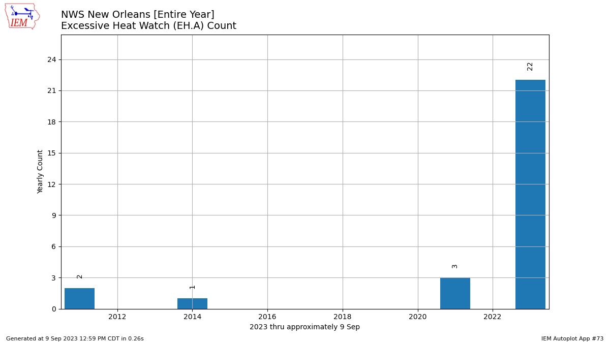
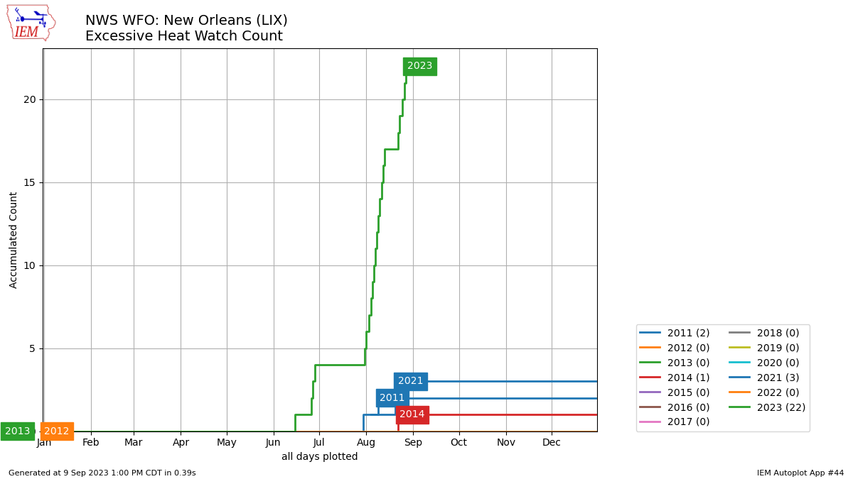
The EH.A (Excessive Heat Watch) that was issued 1832Z 6/15/23 is the earliest in the year our WFO has issued on local VTEC records and only watch we've issued in June.


Top 3 Earliest in the year issuance of Excessive Heat Watch [EH.A]:


Earliest: 6/15/2023 (061523_1832Z)

2nd Earliest: 07/29/2021 (072922_1840Z)

3rd Earliest: 08/05/2011 (080511_0841Z)


Top 3 Greatest total number of Excessive Heat Watches [EH.A] issued in a single year:


(21) 2023: [06-16, 06-27, 06-28, 06-29, 08-01, 08-02, 08-04, 08-05, 08-06, 08-07, 08-08, 08-09, 08-10, 08-11, 08-12, 08-13, 08-14, 08-23, 08-24, 08-26, 08-27]

(3) 2021: [07-31, 08-21, 08-22]

(2) 2011: [08-05, 08-10]


Top 3 consecutive days of Excessive Heat Watches [EH.A] issued in a single year:


(11 days) 2023: [08-04 thru 08-14]

(3 days) 2023: [07-27 thru 07-29]

(2 days) 2021 [08-21, 08-22], 2023 [08-23, 08-24], 2023 [08-26, 08-27], 2023 [08-01, 08-02]


Graphical perspective courtesy of IEM (Updated 9/9):