Experience with Gulf of America tropical cyclone events over the past three decades, including 2023’s Hurricane Idalia, has proven the geographical area south and west of Interstate-75 requires special treatment for the tropical cyclone wind products and communication to the public/core partners. This is especially true concerning the inland wind decay from landfalling Gulf/Apalachee Bay events.
These changes are designed to enhance service in areas with close proximity to the Gulf of America while causing minimal disruption to existing NWS program zone associations (Tropical). As these are Inland counties, there would be NO need to associate new zone numbers with the Tropical Cyclone Wind Breakpoints or the Storm Surge Communication Points.
This zone realignment is scheduled for March 5, 2024
If severe weather precludes the original implementation, the primary backup date is March 6, and March 7 is a secondary.
The local NWS office has reconfigured both Public and Frie Weather Zones several times, including changes previously made to Duval County in 2015 and again in 2021 along the St Johns River (Duval, Clay, and Putnam Counties). Other offices throughout the country have also completed Zone reconfigurations to fit their local weather differences. These reconfigurations have provided increased forecast detail, especially when dealing with fire weather and tropical conditions. Any Zone reconfiguration intends to better serve the public and local officials, including emergency management.
Below we will use a series of figures/maps to illustrate the current Zones, why these changes are necessary, and how they will be implemented.
These first two figures demonstrate an overview of the Columbia and Hamilton counties changes, followed by a more detailed explanation for each county/Zone change. Please click on the thumbnails for a larger version of the image.
|
Figure 1
|
Figure 2
|
|||
 |
 |
|||
| Click to Enlarge the Image | ||||
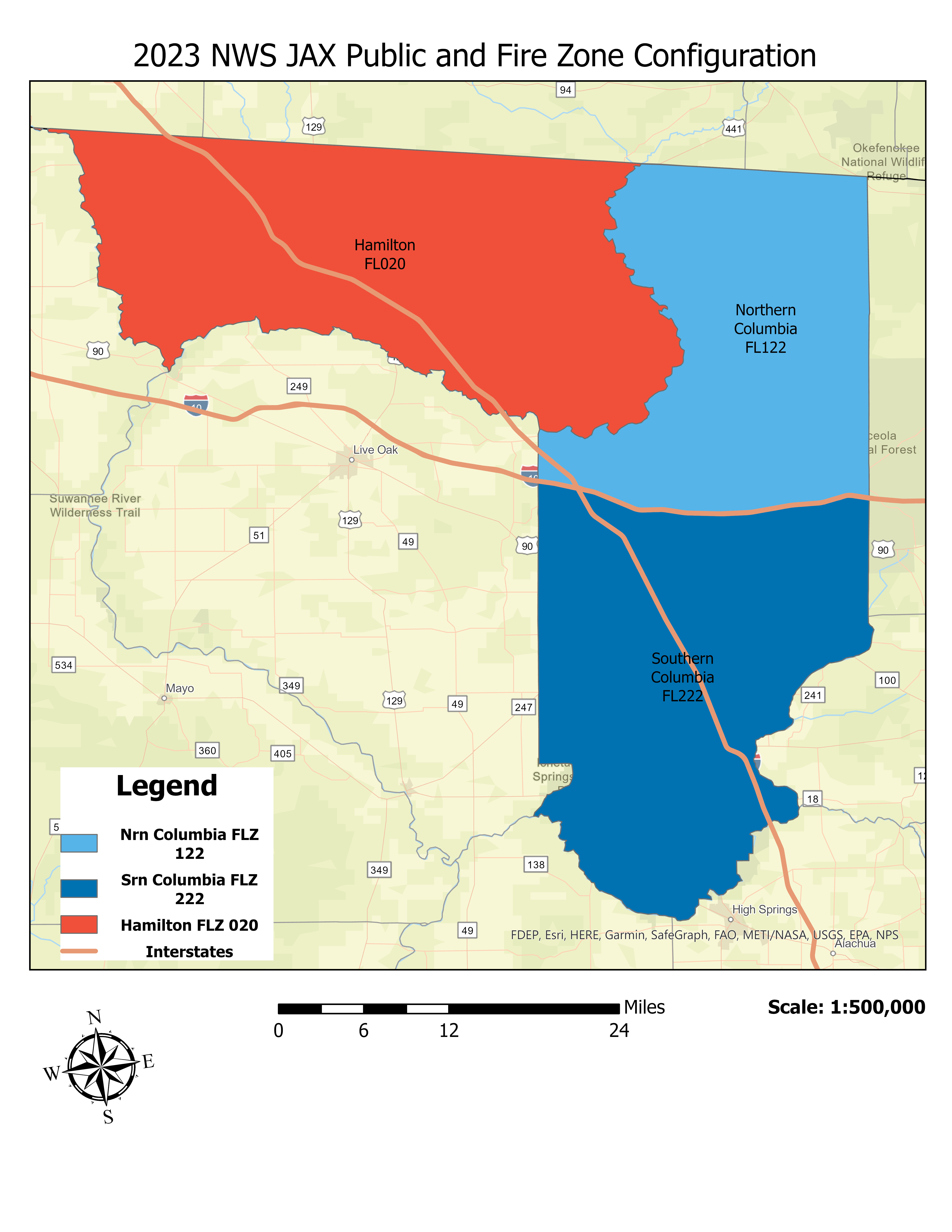
Figure 1 (left) depicts the current (2023) Public and Fire Weather Zone configuration for Columbia and Hamilton counties, which will be reconfigured in 2024. Currently, Columbia County is divided into a northern and southern Zone, whereas Hamilton County exists as an entire zone itself.
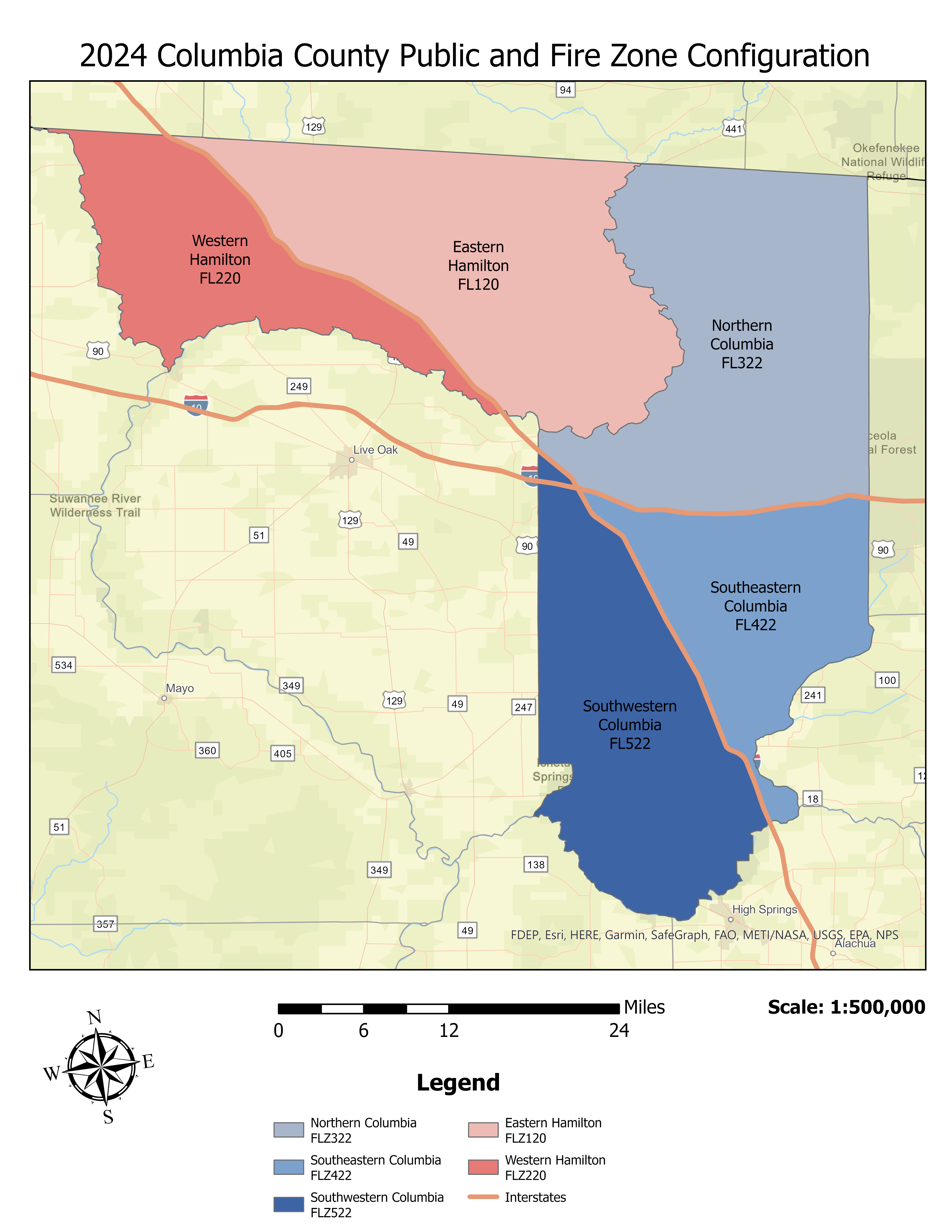
Figure 2 (right) illustrates the upcoming zone changes in 2024. Lessons learned during Hurricane Idalia provoked this realignment, and these changes will allow NWS Jacksonville to better warn threatened areas without warning less threatened, more eastward/inland locations.
Hamilton County is currently a single zone, yet the extreme southwest portion of the county is 45 SM from the Gulf Coast, while the County Seat of Jasper is 60 SM from the same point. During Hurricane Idalia a wide range of damage was observed across the county, with more significant damage to the south and west of Interstate 75. This was consistent with NWS Jacksonville's messaging that the areas southwest of the Interstate would indeed see the most significant impacts, yet using the current Zone configuration, a map sent to the Core Partners, by necessity, indicated significant impacts for the entire county. A similar situation was observed with Hurricane Hermine in 2016. The proposed Zone reconfiguration along I-75 would enhance messaging consistent with observed inland wind decay levels. With this configuration, it would be possible to have a Hurricane Warning confined to areas west of I-75 and a tropical storm warning east of there. A similar situation could be envisioned with a strong tropical storm landfall with a Tropical Storm Warning confined west of I-75 and Tropical Storm Watches to the east of that point.
|
Figure 5
|
Figure 6
|
|||
 |
 |
|||
| Click to Enlarge the Image | ||||
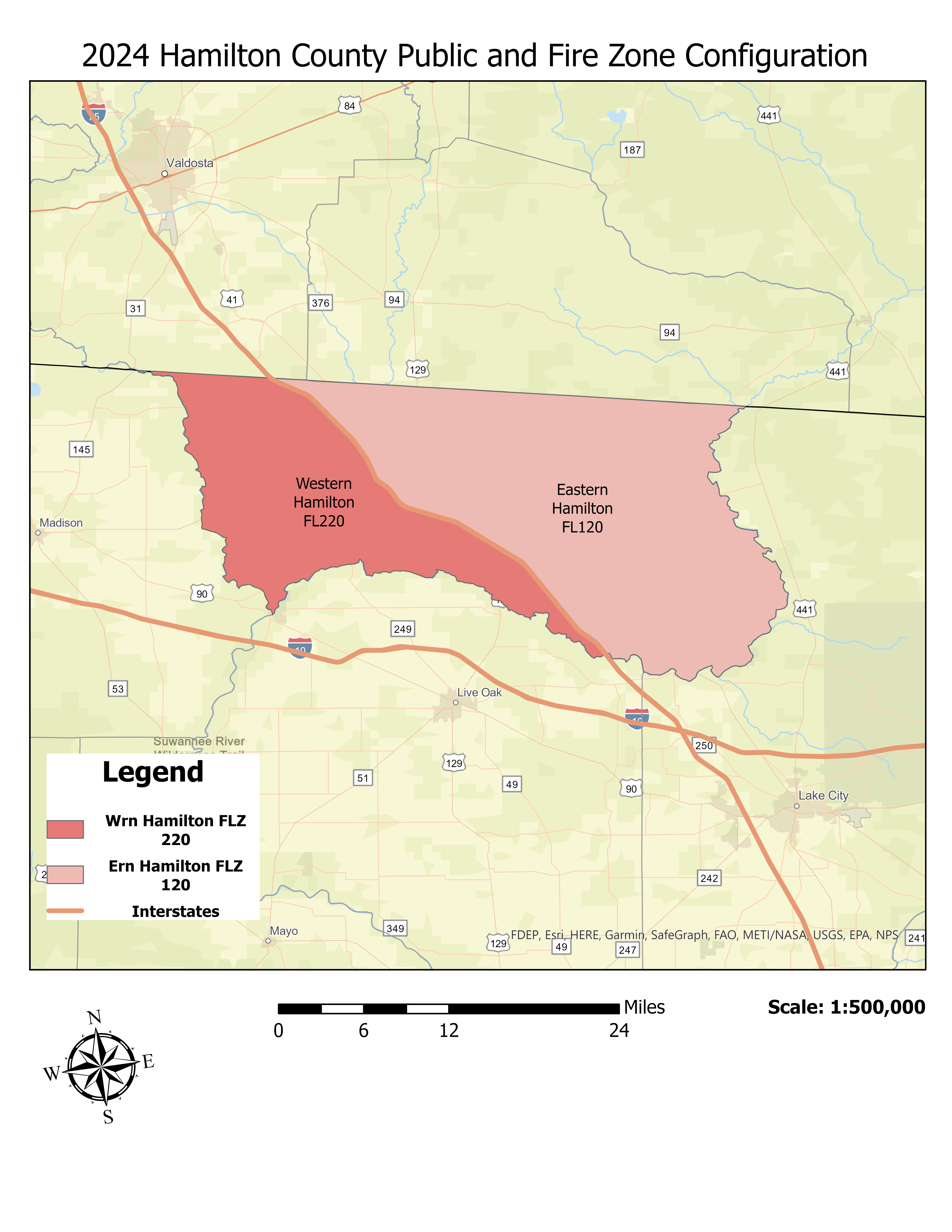
Figure 5 (left) shows Hamilton County’s (FLZ 022) current (2023) Zone configuration with Interstate 75 as a reference.
Figure 6 (right) shows the proposed 2024 Zone split for Hamilton County, splitting it into Eastern Hamilton (FLZ 120) and Western Hamilton County (FLZ 220) along Interstate 75.
The justification for this Zone change is identical to that of Hamilton County; indeed, both are “sister counties” with similar issues and mutual aid agreements.
|
Figure 7
|
Figure 8
|
|||
 |
 |
|||
| Click to Enlarge the Image | ||||
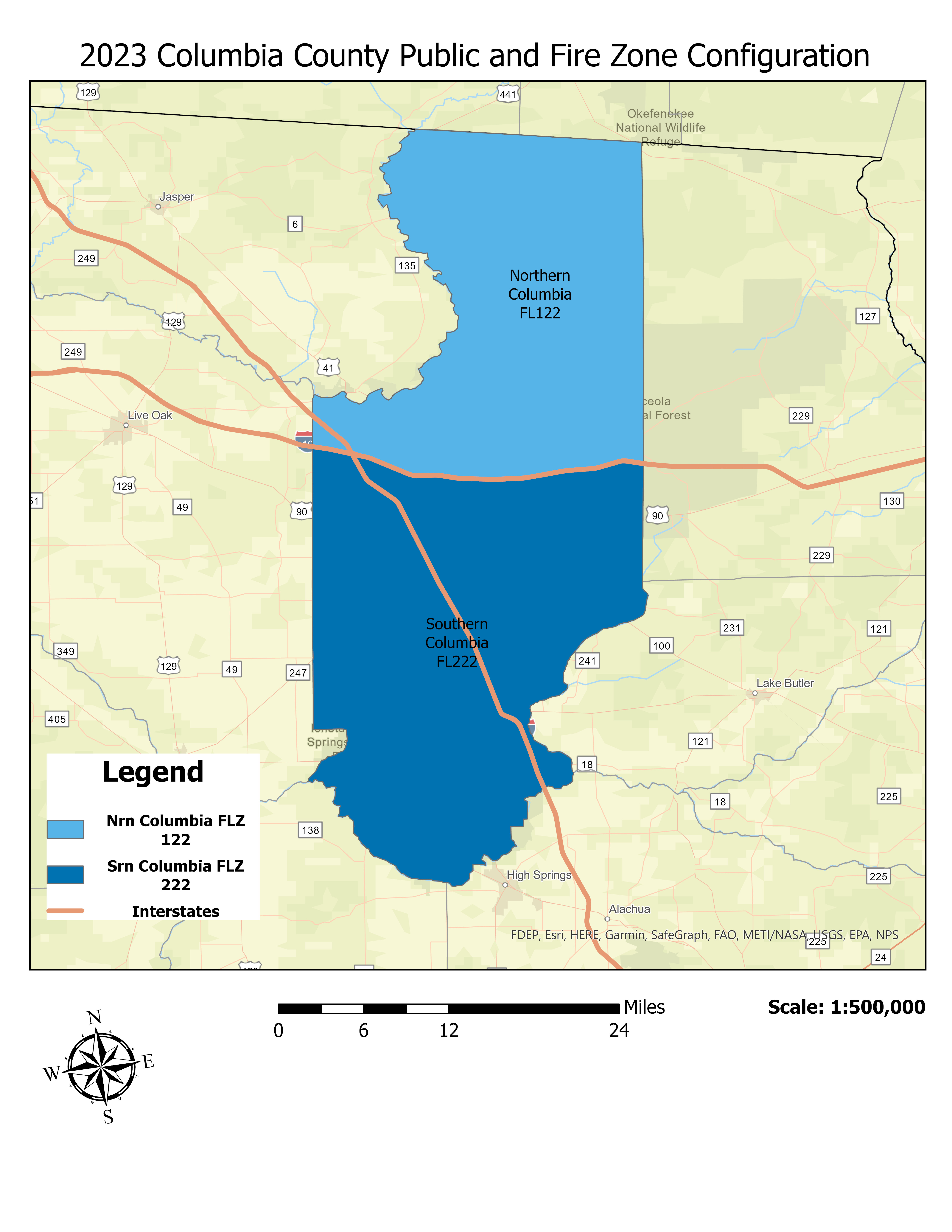
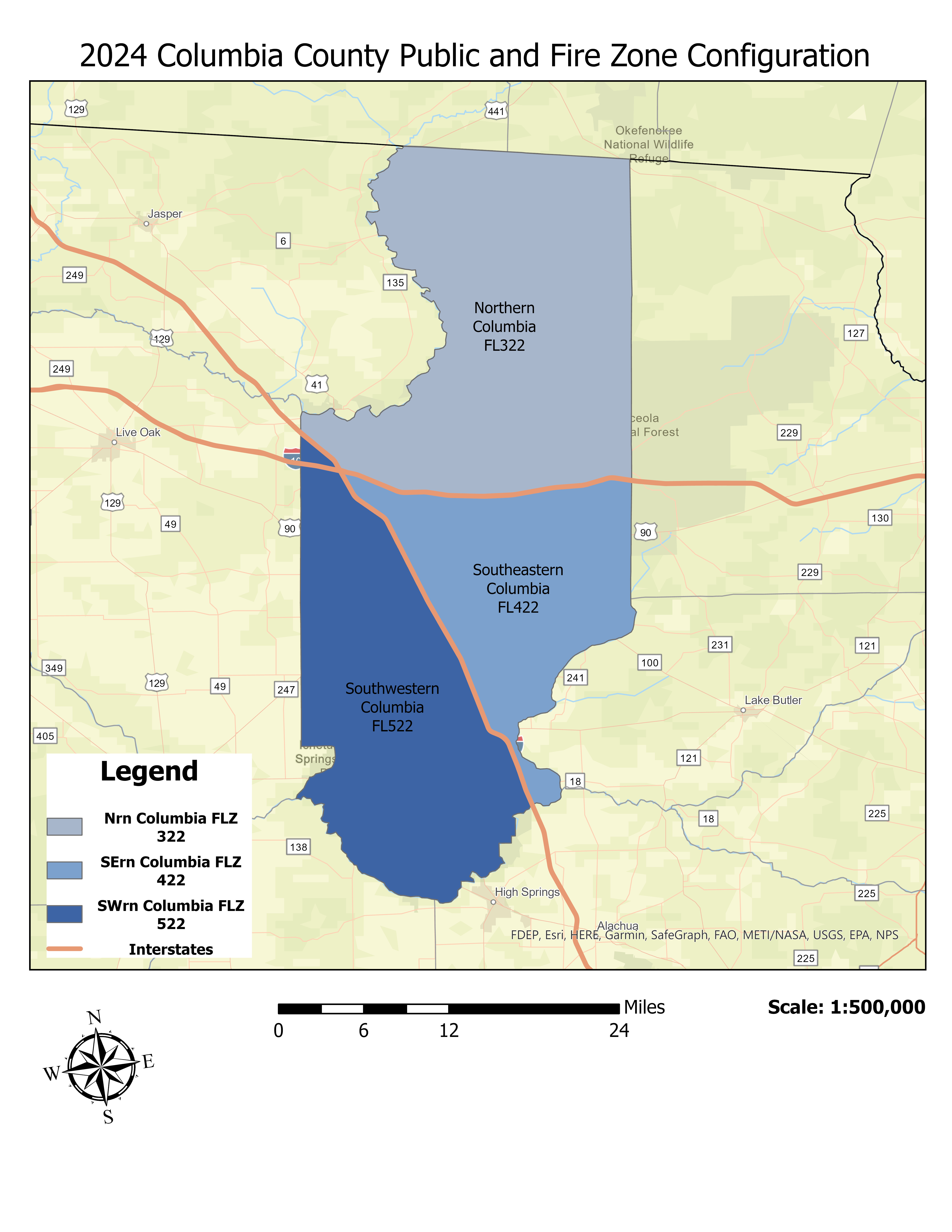
Following the same approach as with Hamilton County above, Figure 7 (left) shows the 2023/current Zone configuration for Columbia County with Interstate 10 and Interstate 75 overlayed for reference.
Figure 8 (right) depicts the new 2024 Columbia County Zone Configuration County with Northern Columbia, slightly trimmed and renumbered to FLZ 322. Additionally, Southern Columbia County is now split into two segments: a Southeastern Columbia County Zone (FLZ 422) and a Southwestern Columbia Zone (FLZ 522). The Southwestern Columbia Zone has a portion of the old Northern Columbia Zone merged into it to create the new Southwestern Columbia Zone encompassing all areas west of Interstate 75. As noted above, this will aid in tropical program messaging.
|
Figure 9
|
||||
|
|
||||
| Click to Enlarge the Image | ||||
Once again, for reference purposes, Figure 9 (right) shows all 2024 Zone changes for Hamilton and Columbia Counties.

