Overview
|
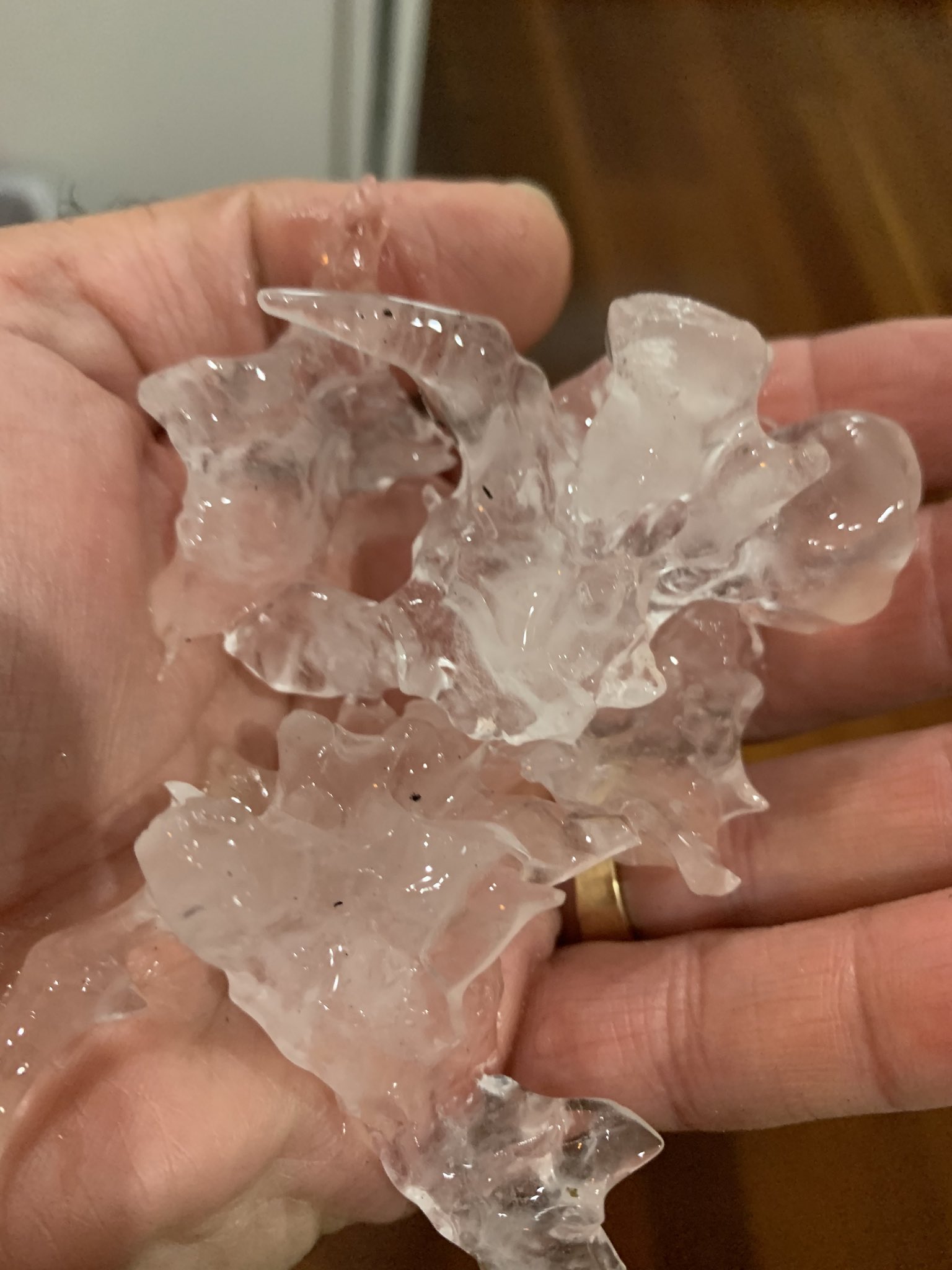
On the evening of Tuesday, August 4, 2020, a very rare event of hail of 2" in diameter occurred on the west side of Jacksonville, FL. To give you an idea of how rare hail this large is here this time of year, this is only the 3rd time on record (1955-2020) that the state of Florida has had a 2" hail report in the month of August. The office received hail reports between 7:25 PM to 8 PM EDT ranging in size from approximately 1-2" in diameter. The image at right is the largest we saw reported online through Twitter, but radar data indicates that hail even larger than this could have fallen somewhere in our area. |
 Picture of large hail from the west side of Jacksonville taken by Emily Ramondetta. |
Radar
Vertical Cross-Sections
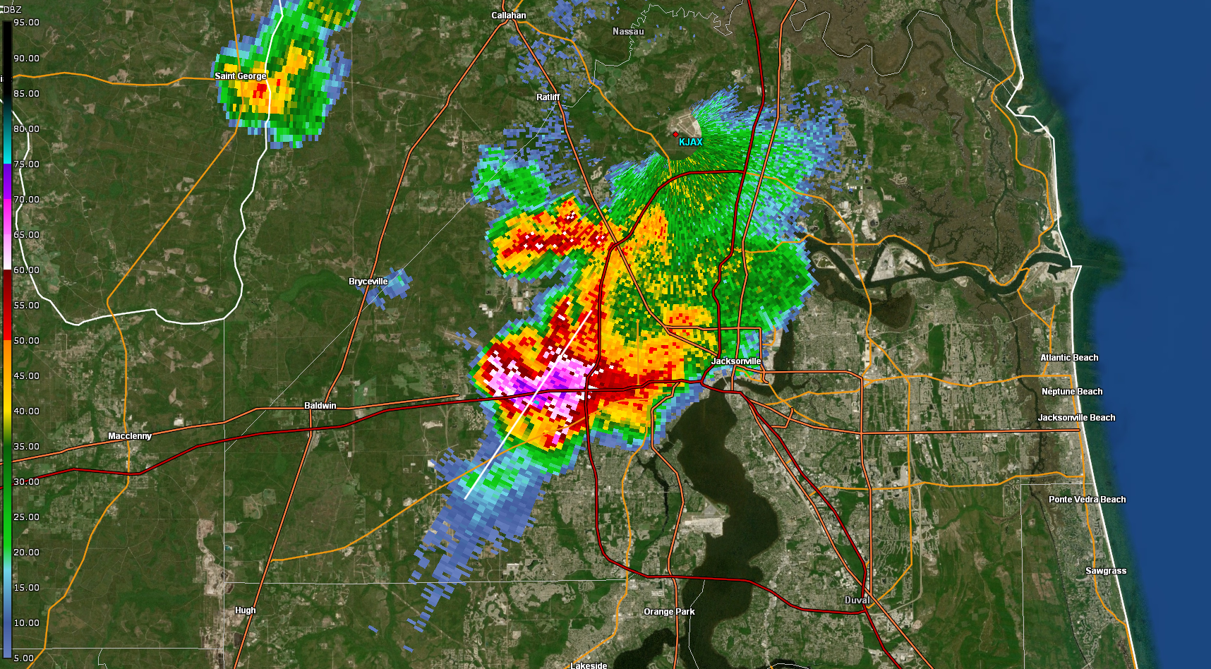
Below is some radar imagery of the reflectivity from our two nearby radars, KJAX and KVAX, at the approximate time that the hail core aloft was at its peak (7:15-7:20 PM EDT). The 00Z (8 PM EDT) KJAX sounding on the next tab shows the freezing level to be at 15,000 ft above the surface, the -20C level to be about 27,000 ft, and -30C level at 32,000 ft. Hail growth typically occurs between the -10C and -30C levels.
 |
 |
 |
 |
| Plane view of hail aloft of western Jacksonville at 8/4/20 23:21Z (7:21 PM EDT) as seen on the 19.4 tilt off of KJAX. The highest reflectivity values seen here are approximately 26,000 ft in the air. | Vertical cross-section of the hail aloft of western Jacksonville at 7:21 PM EDT as seen from KJAX. Note- because of the proximity of the celll to the radar, the radar can only "see" to about 30,000 ft. | Plane view of hail aloft of western Jacksonville at 8/4/20 23:16Z (7:16 PM EDT) as seen on the 3.1 tilt off of KVAX. The highest reflectivity values seen here are approximately 27,000 ft in the air. | Vertical cross-section of the hail aloft of western Jacksonville at 7:16 PM EDT as seen from KVAX. From this view, you can see the storm top goes above 50,000 ft, with high reflectivity from hail above the -30C level. |
Multi-Radar Multi-Sensor and ProbSevere
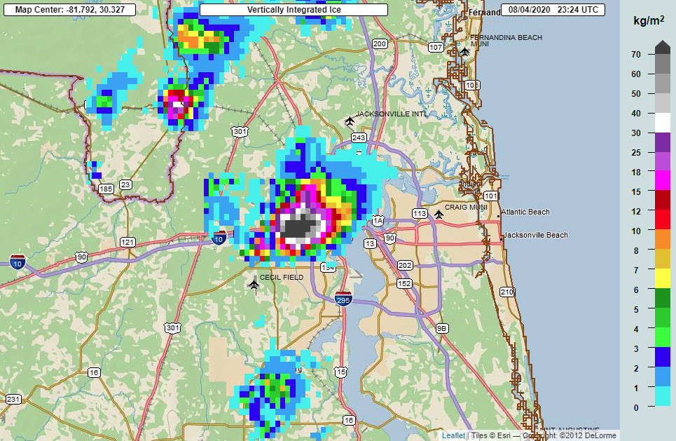
Multi-Radar Multi-Sensor (MRMS) data combines information from multiple datasets to help give us a more complete picture of the features of a given storm. In this case, the maximum estimated hail size from MRMS showed a large area of 2-3" hail for about 10 minutes. Vertically integrated ice is a vertical integration of reflectivity in the -10C to -30C hail growth zone converted to mass per unit area. It can be used to assess storm severity including hail potential. Here, the values exceeded 70 kg/m^2 for several minutes, indicating a very strong updraft. Persistent rotation tracks are yet another way to diagnose how well organized a storm is and its potential to produce severe weather. The one hour track shows strong rotation associated with the cell that produced this large hail. Finally, ProbSevere is a tool to estimate the chances a storm will produce severe hail (greater than or equal to 1" in diameter), severe winds (greater than or equal to 58 mph), or a tornado. Approximately 20 minutes before our report of golf ball size hail, this dataset showed a 72% chance for severe hail.
 |
 |
 |
 |
|
MRMS Maximum Estimated Hail Size - 8/4/20 at 23:22Z (7:22 PM EDT) 50-75 mm = 2-3" diameter hail |
MRMS Vertically Integrated Ice - 8/4/20 at 23:24Z (7:24 PM EDT) 70 kg/m^2 ~ 0.1 lb/in^2 |
MRMS Low Level Rotational Track 1 hr - 8/5/20 00:12Z (8/4/20 8:12 PM EDT) Higher values = stronger rotation |
NOAA/CIMSS ProbSevere values for the cell at 7:10 PM EDT showing a high chance for large hail about 20 minutes before the hail fell. |
Photos & Video
Collection of Twitter Reports from August 4, 2020
August 4th Large Hail - Curated tweets by NWSJacksonvilleEnvironment
The synoptic pattern featured mid and upper level troughing over the eastern CONUS, with a weak Atlantic ridge of low level high pressure centered east of the Jacksonville area. Winds at 500 and 300 mb were from the southwest, meanwhile surface winds from the east after the seabreeze front had moved inland. This resulted in creating some directional shear to help maintain storms that evening. The 500 mb observations also show temperatures -6C at that level, which is colder than normal for our area this time of year and is an indicator of the instability and hail potential. At 300mb, contours of divergence aloft indicate strong rising motion over the region.
 |
 |
 |
| 8/5/20 00Z WPC Surface Analysis | 8/5/20 00Z 500 mb Observations, Heights, and Temperatures | 8/5/20 00Z 300 mb Observations, Isotachs, Streamlines, and Divergence |
A closer look at the 00Z sounding will reveal that there was 43 kts of cloud layer shear available for this storm along with plenty of instability as seen in the SBCAPE of almost 3500 J/kg and 0-3 km lapse rates of 7.2 C/km. The supercell composite as calculated by the RAP analysis that evening was 2 over northeast Florida, indicating the potential for supercell development. Supercells are storms with a rotating updraft and have a high propensity for producing severe weather including damaging winds, very large hail, and tornadoes. In this case, the supercell produced very large hail.
 |
 |
 |
|
8/5/20 00Z KJAX Sounding Sounding features almost 3500 J/kg SBCAPE, 7.2 C/km 0-3 km lapse rates, and 43 kts cloud layer shear. |
8/4/20 23Z RAP analysis showed a Supercell Composite Paramter (SCP) of 2 over the eastern edge of the FL/GA state line. | 8/4/20 23Z RAP analysis showed a bullseye of 4000 J/kg SBCAPE just off the Atlantic coastline, with an area of 3000-4000 J/kg SBCAPE over NE FL. |
 |
Media use of NWS Web News Stories is encouraged! Please acknowledge the NWS as the source of any news information accessed from this site. |
 |