Overview
|
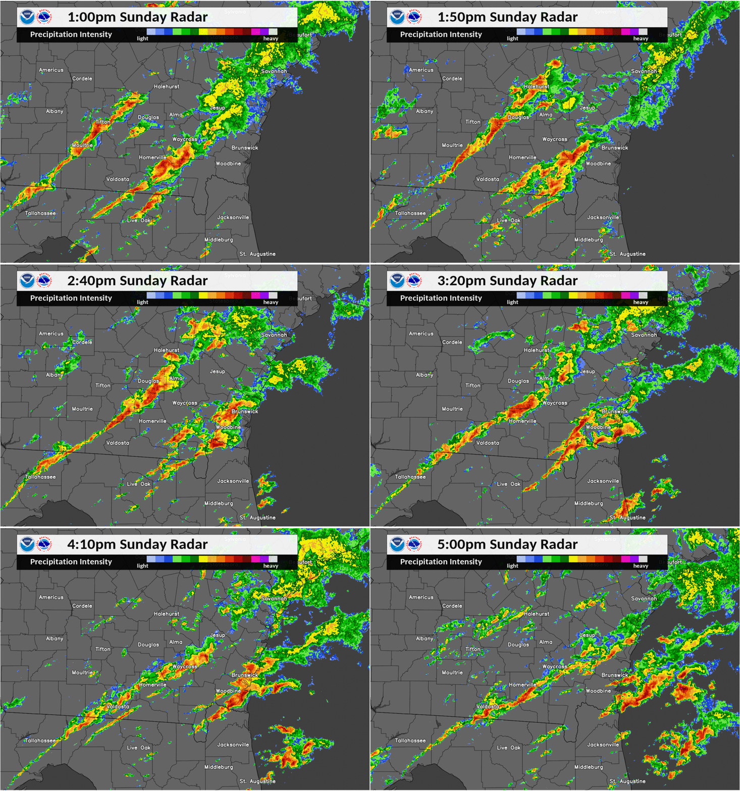
On Sunday December 2, 2018, severe thunderstorms developed over South Georgia during the early afternoon hours. A moist and unstable airmass was in place ahead of a strong cold frontal boundary draping southward towards the Gulf coast from a developing surface low centered over northern Illinois. This low pressure system was supported by a strong positively tilted mid level trough over the mid and lower Mississippi Valley with strong shortwave energy rounding the base of the trough along the gulf coast. An initial line of severe thunderstorms moving eastward across southeast Georgia during the late morning hours developed another line of thunderstorms behind it. This new line gained characteristics of a Quasi Linear Convective System and pushed east from Tifton towards Waycross during the early afternoon. A brief QLCS tornado formed in Atkinson county 6 miles southeast of Willacoochee and 8 miles west of Pearson just south of Highway 82 that caused minor EF-0 damage to trees and then reformed just north and west of Pearson briefly, causing minor damage to a home. |
 Caption |
Tornadoes:
|
Tornado - LOCATION
Track Map .jpg) 
Downloadable KMZ File |
||||||||||||||||
The Enhanced Fujita (EF) Scale classifies tornadoes into the following categories:
| EF0 Weak 65-85 mph |
EF1 Moderate 86-110 mph |
EF2 Significant 111-135 mph |
EF3 Severe 136-165 mph |
EF4 Extreme 166-200 mph |
EF5 Catastrophic 200+ mph |
 |
|||||
Photos & Video
Header
 |
 |
 |
 |
|
Pearson, GA Courtesy of Atkinson County Emergency Management |
Pearson, GA Courtesy of Atkinson County Emergency Management |
Pearson, GA Courtesy of Atkinson County Emergency Management |
Atkinson county, GA Courtesy of Atkinson County Emergency Management |
Radar
A debris ball signature is visible at the 1911Z Sails cut located 2 miles south of US82 and about 7 miles west of Pearson in Atkinson county Georgia. This debris ball signature coincides with base reflectivity values of 50 to 55 DBZ along with a rotational velocity of over 45 knots where the first brief tornado formed.
 |
 |
 |
 |
|
Figure 1: KVAX Base Reflectivity Image at the 1911Z Sails Cut |
Figure 2: KVAX Base Velocity Image at the 1911Z Sails Cut |
Figure 3: KVAX Correlation Coefficient Image at the 1911Z Sails Cut |
Figure 4: KVAX Imagery of Base Reflectivity and Velocity from 1903Z to 1954Z |
Storm Reports
PRELIMINARY LOCAL STORM REPORT
National Weather Service Jacksonville FL
446 PM EST SUN DEC 2 2018

..TIME...   ...EVENT...      ...CITY LOCATION...     ...LAT.LON...
..DATE...   ....MAG....      ..COUNTY LOCATION..ST.. ...SOURCE....
            ..REMARKS..

0214 PM     TORNADO          6 SE WILLACOOCHEE       31.29N 82.97W
12/02/2018                   Atkinson           GA   OFFICIAL NWS OBS

            RADAR OBSERVATIONS INDICATED A TDS SOUTH OF HIGHWAY 82 IN
            MOSTLY RURAL TERRAIN. NO DAMAGE REPORTS HAVE BEEN
            REPORTED AT THIS TIME. TIME ESTIMATED USING RADAR DATA.
PRELIMINARY LOCAL STORM REPORT...CORRECTED
National Weather Service Jacksonville FL
344 PM EST MON DEC 3 2018

..TIME...   ...EVENT...      ...CITY LOCATION...     ...LAT.LON...
..DATE...   ....MAG....      ..COUNTY LOCATION..ST.. ...SOURCE....
            ..REMARKS..

0214 PM     TORNADO          6 SE WILLACOOCHEE       31.29N 82.97W
12/02/2018  F0               Atkinson           GA   EMERGENCY MNGR

            ATKINSON COUNTY EMERGENCY MANAGEMENT REPORTS TREES BROKEN
            OFF AT THE TOPS AND DAMAGE CONSISTENT WITH EF-0 INTENSITY
            IN BETWEEN COUNTY ROAD 38 AND LAZY NINE ROAD TO THE SOUTH
            OF U.S. HIGHWAY 82. TIME ESTIMATED USING RADAR DATA.
PRELIMINARY LOCAL STORM REPORT
National Weather Service Jacksonville FL
141 PM EST THU DEC 13 2018

..TIME...   ...EVENT...      ...CITY LOCATION...     ...LAT.LON...
..DATE...   ....MAG....      ..COUNTY LOCATION..ST.. ...SOURCE....
            ..REMARKS..

0230 PM     TORNADO          1 NNW PEARSON           31.31N 82.86W
12/02/2018                   Atkinson           GA   PUBLIC

            HOME SECURITY CAMERAS CAPTURED A TORNADO MOVING THROUGH
            THE YARD OF THE PROPERTY AND CAUSED MINOR DAMAGE TO THE
            HOUSE. BASED ON THIS INFORMATION, THE TORNADO WAS GIVEN
            AN ESTIMATED EF-0 RATING WITH NO ADDITIONAL SURVEYING
            EXPECTED.
Environment
Synoptic Overview
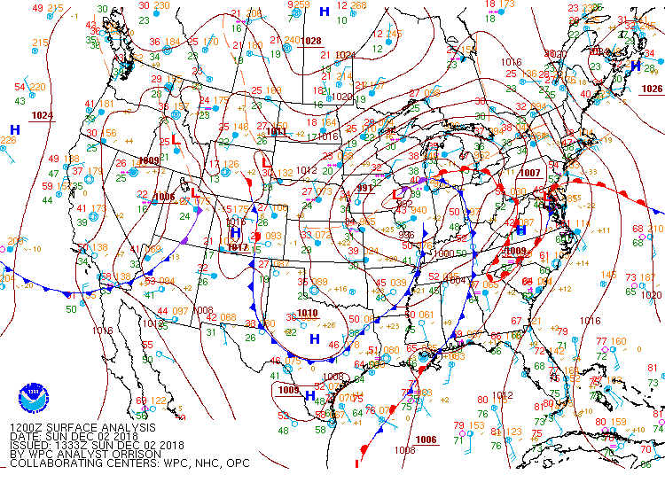
On Sunday morning of Dec 2, 2018 the 12Z WPC surface analysis displayed a cold frontal boundary draped from near Chattanooga, TN southward towards the Gulf coast to near Mobile, AL. Ahead of this front, warm moist air streamed northeastward with dew points in the mid to upper 60s across central and southern GA. A strong low level jet over the NE Gulf of America & FL panhandle was evident on the 12Z analysis with winds from the southwest approaching 50 knots at 850mb. Meanwhile, a vigorous short wave was rotating around the base of a mid level 500mb trough was positioned over the southern Mississippi Valley. Embedded wind speeds up to 60 to 70 knots were just upstream of the region area the 12Z analysis.
 |
 |
 |
| Figure 1: WPC 12Z Surface Analysis Map for December 2, 2018 | Figure 2: SPC 12Z Upper Air Map for December 2, 2018 | Figure 3: SPC 12Z Day 1 Convective Outlook with a Slight risk over SE GA |
Mesoanalysis
The 12Z Jacksonville sounding depicted high levels of instability, shear and veering low level winds. The sounding contained MU Cape values over 2,600 J/Kg, Surface Relative Helicity values close to 300 m2/s2, and a Precipitable Water of 1.80 inches which was well above the 90th percentile for the day, indicating a deep moist environment available for thunderstorm updrafts. The Storm Predication center issued a Mesoscale Discussion at 12Z mentioning isolated severe storms ongoing over central and southwest Georgia may spread into southeast Georgia in the morning and noting that high dewpoints in the upper 60s were advecting northeastward with southwesterly flow measured at 50 knots at 1 km above the surface helping to erode the cooler outflow air with effective SRH values over southeast Georgia rising into the morning and increasing the threat for damaging winds and a brief tornado.
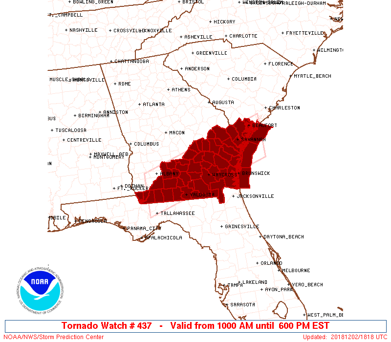
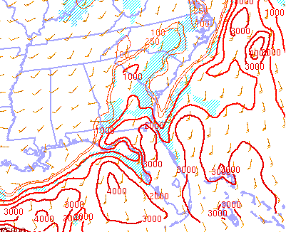
At 15Z, A tornado watch was issued by the Storm Predication center for southern Georgia into southern South Carolina until 23Z. The watch included all of the southeast Georgia counties within the Jacksonville area of responsibility with the primary threats including a couple tornadoes, scattered wind gusts up to 70 mph, and isolated large hail up to 1 inch in diameter possible. At 1730Z, another Mesoscale Discussion was issued by the Storm Prediction Center noting that the threat for damaging winds and couple tornadoes had not changed despite the lack of significant boundary-layer heating. A view of the the Storm Predication Center's 18Z mesoanalysis revealed Surface Based Cape values ranging from 1,000 to 1,500 J/kg over southeast Georgia along with effective Bulk Shear Values over 50 knots just north of the Florida/Georgia state line. The persistence of shear and instability in the atmosphere over southeast Georgia set the stage for the line of thunderstorms moving into Atkinson county Georgia to form a brief tornadoes.
 |
 |
 |
|
Figure 4: Jacksonville 12Z Upper Air Sounding |
Figure 5: SPC Mesoscale Discussion #1692 over Southeast Georgia at 12Z |
Figure 6: Tornado Watch #437 issued at 15Z for Southeast Georgia |
 |
 |
 |
|
Figure 7: SPC Mesoscale Discussion #1693 over Southeast Georgia at 1732Z |
Figure 8: SPC 18Z Mesoanalysis of Surface Based Cape |
Figure 9: SPC 18Z Mesoanalysis of Effective Bulk Shear |
 |
Media use of NWS Web News Stories is encouraged! Please acknowledge the NWS as the source of any news information accessed from this site. |
 |