Overview
Following some light snow on the evening of January 19th, a narrow band of heavy snow raced through the area near midnight.
Snow/Ice
Snow reports typically ranged from a dusting to just over 4 inches. A list of reports of 1 inch or more can be found under Storm Reports.
Photos & Video
This was the scene outside our office in Syracuse, IN around 12:30 AM EST. Visibility was significantly reduced. We received 1.5"of snow from midnight to 1 AM.
The intense band of snow has arrived at our office in Syracuse. SR 13 is somewhere just beyond those bushes.
— NWS Northern Indiana (@NWSIWX) January 20, 2021
If you’re out early this morning, be alert for changing conditions! #inwx pic.twitter.com/1HLr6zEUO4
Radar
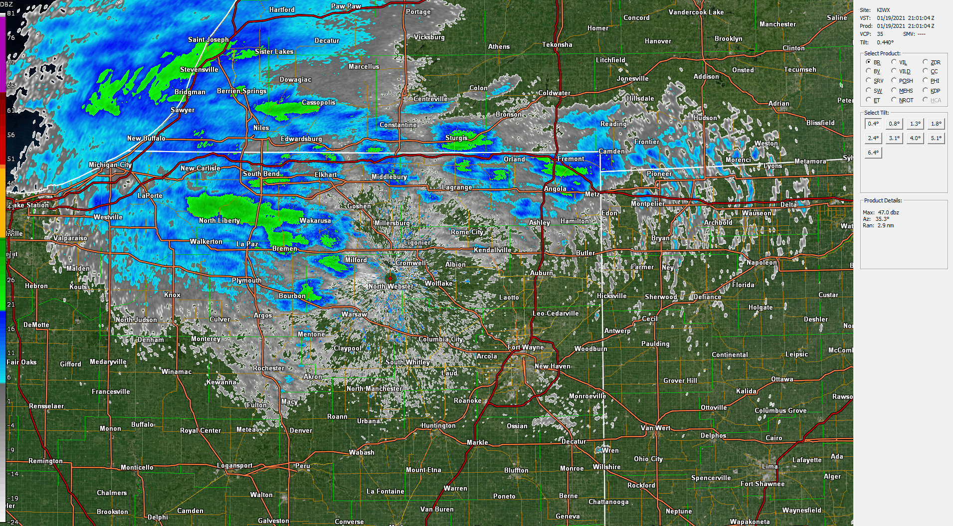
Snow spread in from west to east beginning in the late afternoon. Note that there was some lake-enhanced snow in Berrien County due to the winds from the west. Then, around 11 PM EST (04z), a heavy band of snow raced from northwest to southeast. This resulted in visibility below 1/4 mile and quick 1+" snow accumulations, on top of the light snow that had already fallen.
 |
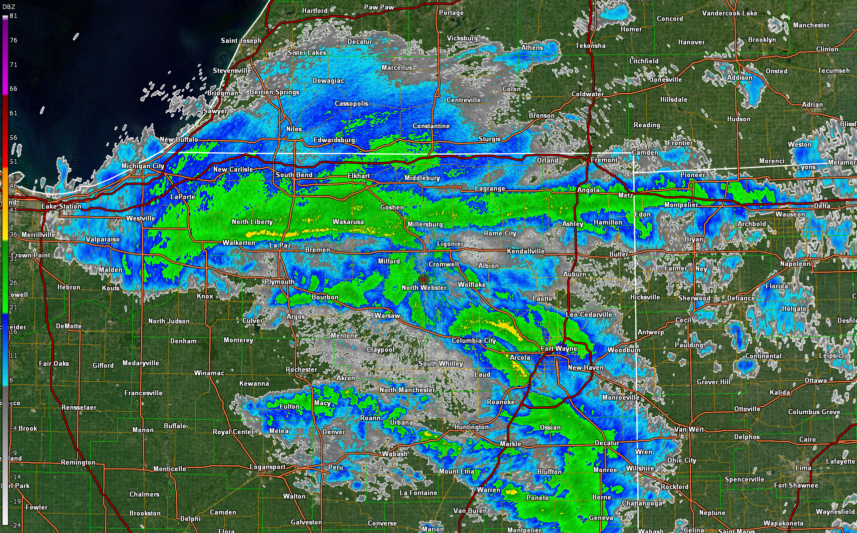 |
| Radar loop from 4PM EST on 1/19 through 2 AM EST on 1/20 (21z-07z) | Around 11:52 PM EST, thunder snow was reported in an area from South Bend to Nappanee. |
Storm Reports
...SNOWFALL REPORTS FOR JANUARY 19 THROUGH 20TH, 2021...
LOCATION AMOUNT TIME/DATE LAT/LON
...INDIANA...

...ALLEN COUNTY...
2 W WOODBURN                 2.5 IN    0730 AM 01/20   41.13N/84.89W
3 ENE WALLEN                 1.3 IN    0822 AM 01/20   41.18N/85.10W
WOODBURN 3 N                 1.1 IN    0700 AM 01/20   41.16N/84.85W
HUNTERTOWN 2.6 ESE           1.0 IN    0800 AM 01/20   41.21N/85.12W

...DE KALB COUNTY...
0.6 S GARRETT                2.0 IN    0700 AM 01/20   41.34N/85.13W
ASHLEY                       1.8 IN    0900 AM 01/20   41.51N/85.13W

...ELKHART COUNTY...
GOSHEN 3.0 WSW               2.2 IN    0700 AM 01/20   41.56N/85.88W
WAKARUSA 2.4 NNE             2.1 IN    0700 AM 01/20   41.57N/85.99W
ELKHART 4.8 SW               2.0 IN    0800 AM 01/20   41.64N/86.04W
1.9 W ELKHART                2.0 IN    1200 AM 01/20   41.68N/86.00W
GOSHEN 2.8 NW                1.5 IN    0915 AM 01/20   41.60N/85.88W
GOSHEN 2.3 WNW               1.5 IN    0800 AM 01/20   41.59N/85.88W
GOSHEN 0.3 NE                1.2 IN    0700 AM 01/20   41.58N/85.83W

...KOSCIUSKO COUNTY...
LEESBURG 6.7 ESE             2.9 IN    0700 AM 01/20   41.31N/85.72W
1 S JAMES LAKE               2.8 IN    0200 AM 01/20   41.31N/85.72W
NWS NORTHERN INDIANA         2.6 IN    0700 AM 01/20   41.36N/85.70W
LEESBURG 0.1 WNW             2.0 IN    0800 AM 01/20   41.33N/85.85W
MILFORD 0.9 N                2.0 IN    0700 AM 01/20   41.42N/85.85W
WARSAW 3.7 E                 1.5 IN    0730 AM 01/20   41.23N/85.78W
WARSAW 1.4 N                 1.5 IN    0615 AM 01/20   41.26N/85.85W
WARSAW 3.0 SE                1.2 IN    0800 AM 01/20   41.21N/85.80W

...LA PORTE COUNTY...
0.8 W LA PORTE               3.1 IN    0100 AM 01/20   41.61N/86.73W
LA PORTE 2.3 ESE             2.0 IN    0930 AM 01/20   41.59N/86.68W
MILL CREEK 1.9 NNE           1.9 IN    0800 AM 01/20   41.61N/86.52W
LA PORTE 1.6 SW              1.6 IN    0800 AM 01/20   41.59N/86.73W

...MARSHALL COUNTY...
1.2 W PLYMOUTH               1.5 IN    0530 AM 01/20   41.34N/86.34W

...NOBLE COUNTY...
KENDALLVILLE 4.5 NW          1.0 IN    0700 AM 01/20   41.50N/85.31W

...ST. JOSEPH COUNTY...
1 NE GRANGER                 3.8 IN    1230 AM 01/20   41.75N/86.13W
GRANGER 1.8 ENE              2.9 IN    0700 AM 01/20   41.75N/86.11W
SOUTH BEND 4.6 SE            2.7 IN    0700 AM 01/20   41.62N/86.22W
SOUTH BEND 4.5 SE            2.6 IN    0800 AM 01/20   41.62N/86.22W
1 S ROSELAND                 2.1 IN    1200 AM 01/20   41.70N/86.25W
MISHAWAKA 3.9 ENE            2.0 IN    0720 AM 01/20   41.68N/86.10W

...STEUBEN COUNTY...
ANGOLA 1.7 WNW               3.0 IN    0700 AM 01/20   41.65N/85.03W
ANGOLA 1.2 S                 2.5 IN    0600 AM 01/20   41.62N/85.00W
ANGOLA 4.1 N                 2.5 IN    0545 AM 01/20   41.70N/84.99W
ANGOLA                       2.4 IN    0630 AM 01/20   41.64N/84.99W
HUDSON 4.6 N                 2.3 IN    0715 AM 01/20   41.60N/85.09W
ANGOLA 8.8 ESE               2.1 IN    0800 AM 01/20   41.62N/84.83W
HUDSON 4.1 NNW               1.7 IN    0600 AM 01/20   41.59N/85.10W
HAMILTON 1.7 E               1.3 IN    0700 AM 01/20   41.53N/84.89W

...WHITLEY COUNTY...
COLUMBIA CITY 7.4 N          3.0 IN    0800 AM 01/20   41.26N/85.50W
TRI-LAKES 3.0 N              2.5 IN    0750 AM 01/20   41.26N/85.49W
COLUMBIA CITY 6.9 N          2.5 IN    0700 AM 01/20   41.26N/85.51W
COLUMBIA CITY 4.6 S          1.2 IN    0600 AM 01/20   41.09N/85.47W
COLUMBIA CITY 0.5 WSW        1.1 IN    0800 AM 01/20   41.16N/85.49W
COLUMBIA CITY 1.5 NNW        1.0 IN    0520 AM 01/20   41.18N/85.49W

...MICHIGAN...

...BERRIEN COUNTY...
BERRIEN SPRINGS              4.2 IN    0727 AM 01/20   41.95N/86.34W
STEVENSVILLE 1.7 SSE         4.2 IN    0700 AM 01/20   41.99N/86.51W
SAINT JOSEPH                 4.0 IN    0943 AM 01/20   42.10N/86.49W
BUCHANAN 1.3 WNW             4.0 IN    0600 AM 01/20   41.84N/86.39W
NILES                        3.8 IN    1200 AM 01/20   41.83N/86.25W
FAIR PLAIN                   3.5 IN    1200 AM 01/20   42.08N/86.45W
SHOREHAM 2.0 SE              3.3 IN    0800 AM 01/20   42.03N/86.49W
BUCHANAN 1.4 ESE             3.0 IN    0700 AM 01/20   41.82N/86.34W
ST. JOSEPH 1.5 SSE           2.1 IN    0700 AM 01/20   42.08N/86.48W

...CASS COUNTY...
CASSOPOLIS 9.0 SSE           4.5 IN    0900 AM 01/20   41.79N/85.95W

...HILLSDALE COUNTY...
LITCHFIELD 0.3 ENE           1.6 IN    0630 AM 01/20   42.05N/84.75W

...ST. JOSEPH COUNTY...
THREE RIVERS 2.4 NE          1.7 IN    0700 AM 01/20   41.97N/85.60W

...OHIO...

...DEFIANCE COUNTY...
DEFIANCE 0.5 E               1.0 IN    0700 AM 01/20   41.28N/84.35W

...FULTON COUNTY...
SWANTON 4.0 S                1.5 IN    0803 AM 01/20   41.53N/83.91W

...HENRY COUNTY...
NAPOLEON 0.6 WSW             1.0 IN    0800 AM 01/20   41.39N/84.14W

OBSERVATIONS ARE COLLECTED FROM A VARIETY OF SOURCES WITH VARYING
EQUIPMENT AND EXPOSURES. WE THANK ALL VOLUNTEER WEATHER OBSERVERS
FOR THEIR DEDICATION. NOT ALL DATA LISTED ARE CONSIDERED OFFICIAL.
$$
Environment
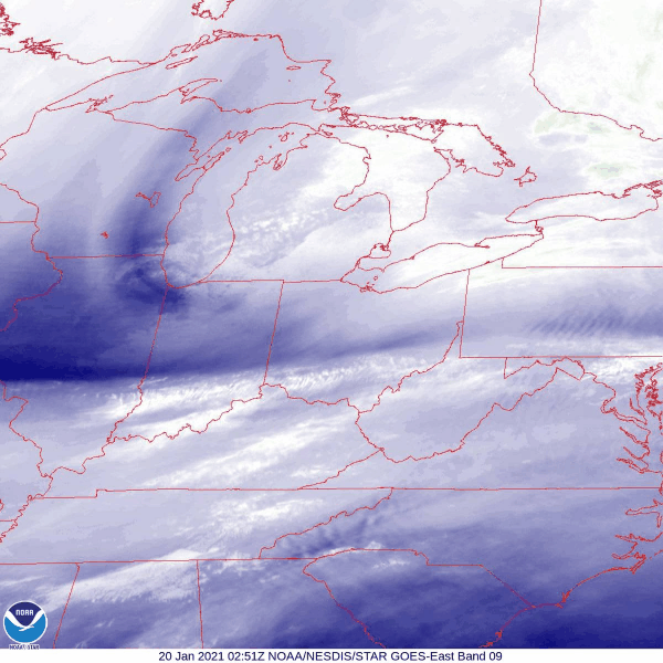
A strong trough diving in from the northwest was the primary driver of this episode of snow. Wind off of Lake Michigan provided lake enhanced snow for locations such as Berrien and Cass counties in Michigan.
 |
 |
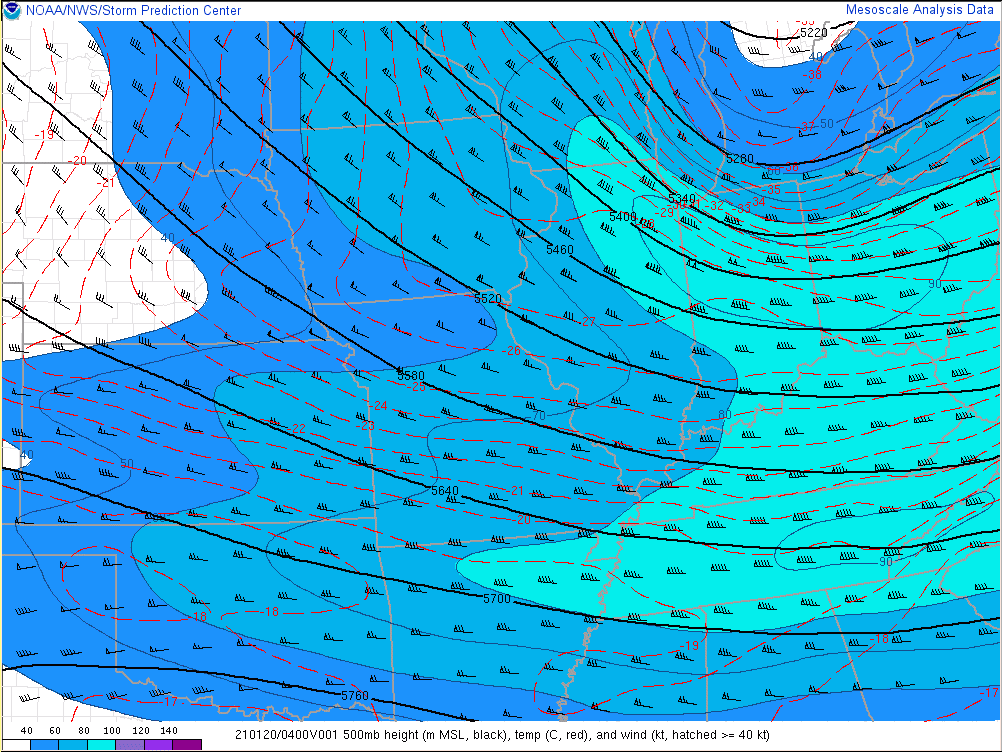 |
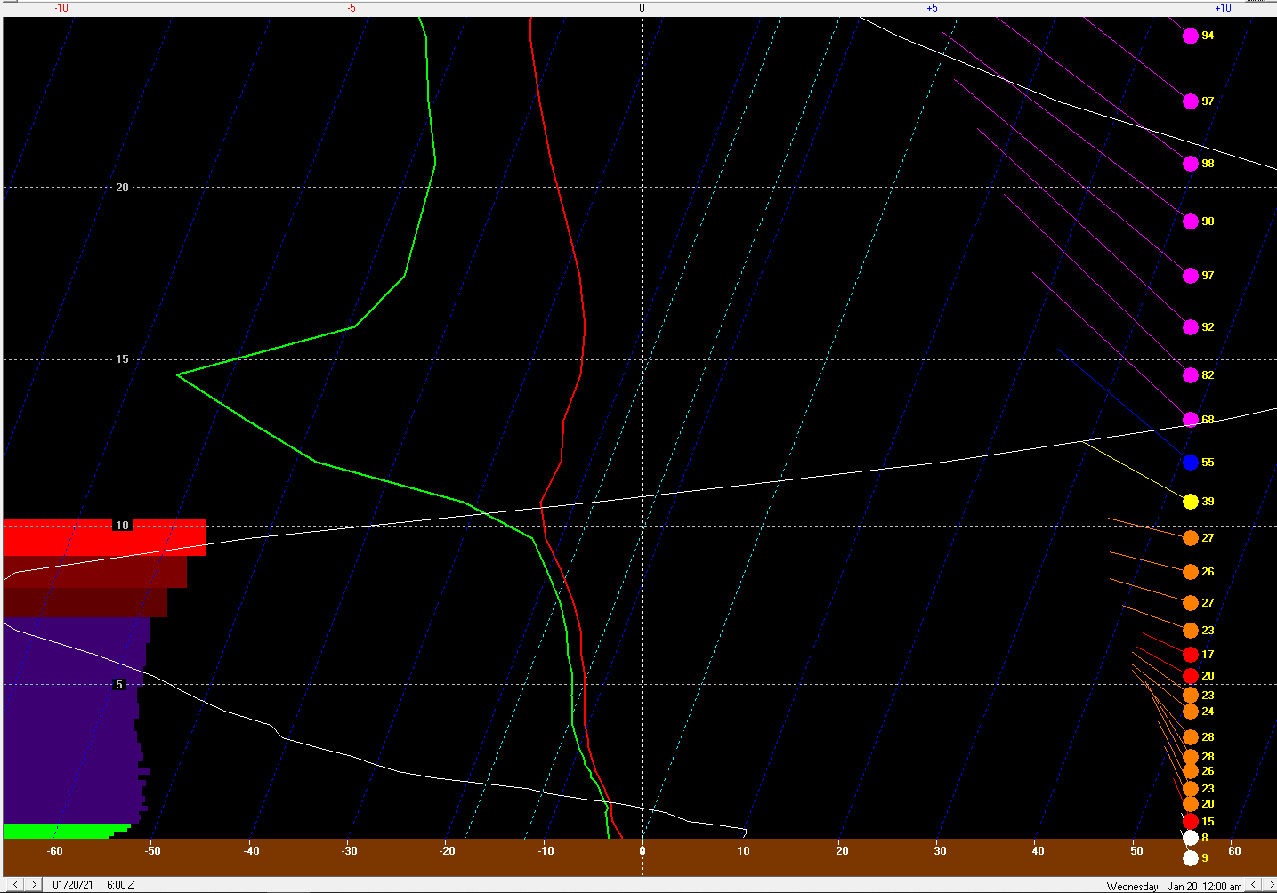
| Figure 1: This mid-level water vapor image shows a robust trough moving from northeast IL through IN. This feature was responsible for the quick burst of heavy snow. | Figure 2: 06z NAM3km forecast sounding, valid at 06z (1AM EST 1/20). Note the favorable conditions for a heavy snow band, including a saturated Dendritic Growth Zone, omega (white line) through the DGZ, and a tall DGZ shy of 5,000 ft. The DGZ defined by a temperature of -10 to -20°C | Figure 3: 04z 500mb. A robust jet near 90 knots proved to be a potent source of lift |
 |
Media use of NWS Web News Stories is encouraged! Please acknowledge the NWS as the source of any news information accessed from this site. |
|

