Overview
A strong upper level storm system overspread the region during the afternoon of July 20th resulting in rapid scattered thunderstorm development across northwest Indiana and southwest Lower Michigan. These storms increased in coverage as they moved across the remainder of northern Indiana during the afternoon and early evening. Pockets of damaging wind gusts were observed with the stronger storms, along with localized flooding. The thunderstorms eventually weakened across northwest Ohio where earlier day storms resulted in more stable conditions.Tornadoes: Page will be updated as new information becomes available
|
Tornado - LaFontaine Wabash County, IN
Track Map 
Downloadable KMZ File |
||||||||||||||||
|
Tornado - Bremen
Track Map
Downloadable KMZ File |
||||||||||||||||
The Enhanced Fujita (EF) Scale classifies tornadoes into the following categories:
| EF0 Weak 65-85 mph |
EF1 Moderate 86-110 mph |
EF2 Significant 111-135 mph |
EF3 Severe 136-165 mph |
EF4 Extreme 166-200 mph |
EF5 Catastrophic 200+ mph |
 |
|||||
Photos & Video:
Damage Photos
 |
 |
 |
 |
| Barn Damage in Nappanee, IN Picture from Emily Kennedy (ABC 57) |
Tree Damage in Silver Lake, IN Picture from David Sloan (Times-Union) |
Large tree uprooted in Silver Lake, IN Picture from Heather Black (WSBT) |
Shelf cloud near Defiance, OH Picture from Shelly Bowers |
 |
 |
 |
 |
| Drone image of the track of the tornado in the Bremen area. Notice the converging striations. From DeWayne Weaver. | Drone image of the track of the tornado in the Bremen area from DeWayne Weaver. | Tree damage near an shed building on America Road in the Wabash area from Keith Walters. | Tree damage near 6809 S 390 E in the Wabash Area from Keith Walters. |
Radar:
Header
 |
 |
||
| Reflectivity/Velocity Loop 1 - 3 pm EDT | Reflectivity/Velocity Loop 3 - 5 pm EDT | Caption | Caption |
Storm Reports
PRELIMINARY LOCAL STORM REPORT...SUMMARY
NATIONAL WEATHER SERVICE NORTHERN INDIANA
541 PM EDT FRI JUL 20 2018

..TIME...   ...EVENT...      ...CITY LOCATION...     ...LAT.LON...
..DATE...   ....MAG....      ..COUNTY LOCATION..ST.. ...SOURCE....
            ..REMARKS..

0420 PM     TSTM WND DMG     HARTFORD CITY           40.45N 85.37W
07/20/2018                   BLACKFORD          IN   TRAINED SPOTTER

            TREE DOWN. TREE DID NOT APPEAR HEALTHY.

0406 PM     HEAVY RAIN       1 N HUNTINGTON          40.89N 85.50W
07/20/2018  M2.00 INCH       HUNTINGTON         IN   PUBLIC

            STORM TOTAL. FROM SOCIAL MEDIA.

0400 PM     TSTM WND DMG     1 NW CRAIGVILLE         40.79N 85.11W
07/20/2018                   WELLS              IN   TRAINED SPOTTER

            13" TREE DOWN, SEVERAL TREE LIMBS SNAPPED.

0339 PM     TSTM WND DMG     HUNTINGTON              40.88N 85.51W
07/20/2018                   HUNTINGTON         IN   TRAINED SPOTTER

            1"-1.25 " TREE BRANCHES DOWN. MINOR STREET
            FLOODING.

0335 PM     TSTM WND DMG     KENDALLVILLE            41.44N 85.26W
07/20/2018                   NOBLE              IN   EMERGENCY MNGR

            LARGE LIMB CAME DOWN ON POWER LINES AT NOBLE
            CTY FAIRGROUNDS.

0322 PM     HAIL             LINCOLNVILLE            40.75N 85.68W
07/20/2018  M1.00 INCH       WABASH             IN   EMERGENCY MNGR

            LASTED FOR 30 SECONDS.

0236 PM     TSTM WND DMG     BEAVER DAM LAKE         41.09N 85.97W
07/20/2018                   KOSCIUSKO          IN   TRAINED SPOTTER

            SEVERAL TREES DOWN. TIME ESTIMATED FROM
            RADAR.

0235 PM     TSTM WND DMG     2 SSW CLUNETTE          41.30N 85.93W
07/20/2018                   KOSCIUSKO          IN   PUBLIC

            3 POWER POLES SNAPPED AND TRANSFORMER DOWN
            IN ROAD. TIME ESTIMATED VIA RADAR.

0215 PM     TSTM WND DMG     1 NW NAPPANEE           41.45N 86.00W
07/20/2018                   ELKHART            IN   BROADCAST MEDIA

            BARN AND ROOF DAMAGE. TIME ESTIMATED FROM
            RADAR.

0206 PM     TSTM WND DMG     ETNA GREEN              41.28N 86.05W
07/20/2018                   KOSCIUSKO          IN   PUBLIC

            TREE LIMBS DOWN, BARN DAMAGE, GRAIN BIN
            DAMAGED AND CORN FLATTENED DOWN. TIME
            ESTIMATED FROM RADAR.

0205 PM     TSTM WND DMG     BOURBON                 41.30N 86.12W
07/20/2018                   MARSHALL           IN   BROADCAST MEDIA

            TREE DOWN ACROSS THE ROAD. TIME ESTIMATED
            VIA RADAR.

1240 PM     TSTM WND DMG     MICHIGAN CITY           41.71N 86.88W
07/20/2018                   LA PORTE           IN   BROADCAST MEDIA

            *** 1 INJ ***
            TREE DOWN ON CAR. AT LEAST 1 INJURED. TIME
            ESTIMATED FROM RADAR.

0715 AM     TSTM WND DMG     1 ENE ANGOLA            41.65N 84.98W
07/20/2018                   STEUBEN            IN   EMERGENCY MNGR

            DAMAGE TO SEVERAL LARGE TREES. SOME TREES
            SNAPPED AT CENTER.


&&

$$
Rain Reports
A map of storm total rainfall coming soon.
 |
||
| Figure 1: AHPS 24 hr precipitation estimate ending 7AM on July 21 so it includes the overnight rain after the event. | Figure 8: Caption | Figure 9: Caption |
Environment
 |
 |
 |
| Figure 1: 16Z 850 mb analysis | Figure 2: 16Z 500 mb analysis | Figure 3: 16Z 300 mb analysis |
|
 |
 |
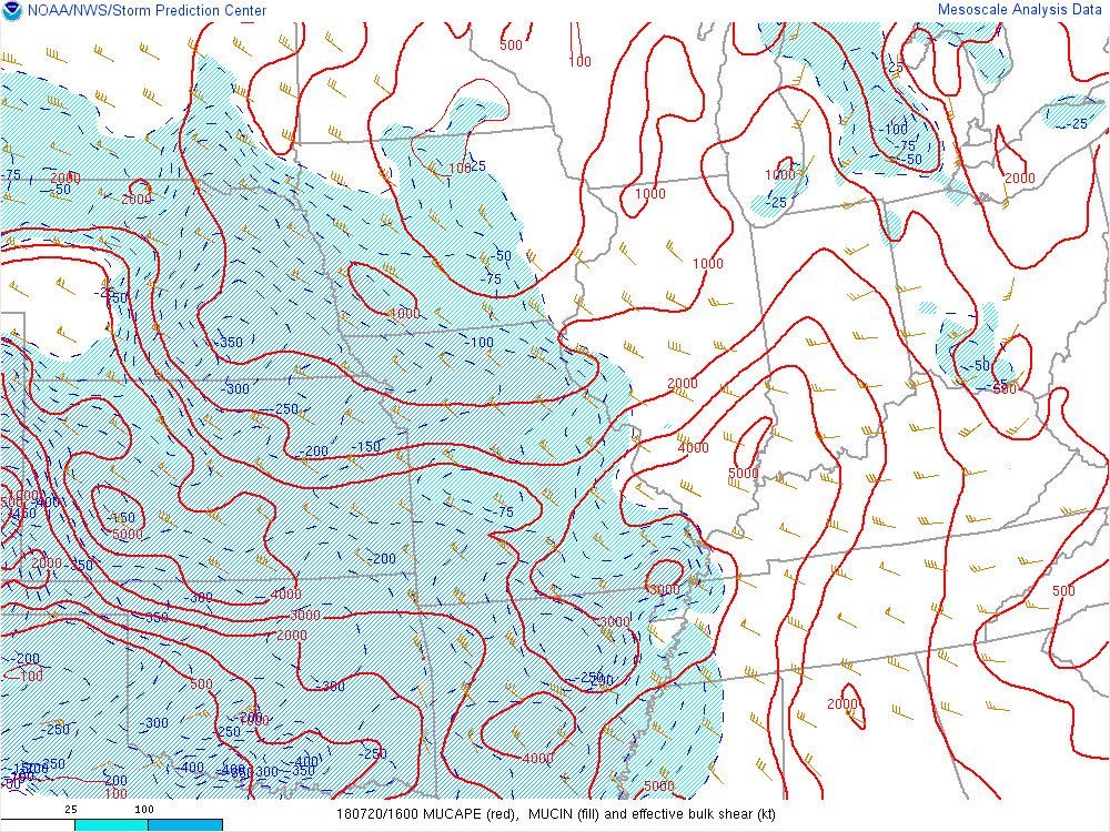
| Figure 4: 16Z (12 pm EDT) MUCAPE and Effective Bulk Shear. Note the best shear was still south of the area | Figure 5: 16Z DCAPE (Values above 1000 J/KG indicate increased threat for damaging winds) | Figure 6: 16Z EHI (Values above 1 indicate increased threat for severe weather, including supercells) |
Additional environmental data.
 |
||
| Figure 7: 1635Z Visible Satellite Image-Note clearing prior to rapid development | Figure 8: Caption | Figure 9: Caption |
 |
Media use of NWS Web News Stories is encouraged! Please acknowledge the NWS as the source of any news information accessed from this site. |
|

