Today weather observers who make up the Cooperative Observing Program are a core of volunteers numbering over 10,600. There history extends back long before there was a National Weather Service. Of these, about 5,000 make up the "climate" network while the remainder of the network supports hydrology or meteorology. This network of volunteer weather watchers has become an American institution. The program and its history of success continue to arouse the envy of other countries around the globe. It has been acclaimed as the most cost-effective weather data collection network in the world.
The all volunteer weather observer network was envisioned by Thomas Jefferson in 1776 when he began to recruit observers in Virginia. By 1800, his vision has spread to five other states. By 1891, the network had grown to nearly 2,000. In 1856 the Honorable Isaac Newton, U.S. Commissioner of Agriculture, endorsed a recommendation by the Secretary of the Smithsonian Institution, Prof. Joseph Henry, that a more extensive weather service be established for the benefit of agriculture. Five years later the U.S. Weather Bureau became a new agency under the U.S. Signal Service. On February 2, 1870, President Ulysses S. Grant signed a joint resolution of Congress authorizing the establishment of a national weather bureau. With the Organic Act of October 1, 1890, all weather functions were transferred to a new agency called the Weather Bureau. Among other duties, one of the primary mandates of the Organic Act was the volunteer weather observer program. This program has evolved into the National Weather Service (NWS) Cooperative Weather Observer Network. Although the network has been very successful in fulfilling its original agriculturally oriented mission of defining the weather and climate of the United States, its data are now used for a myriad of things including water and land management, recreation, environmental impact studies, litigation and insurance, energy production and energy use, engineering, architectural design and construction, and agriculture and farm management, to mention a few. Not only are the Cooperative Weather data invaluable to the NWS, but these data are also the basis for critical business decisions in the private sector. Without these data, the National Weather Service would find it nearly impossible to fulfil its mission.
Today, the Cooperative Observer Network operates basically as it did the first year of its inception over 100 years ago. Cooperative Weather Stations, scattered over all 50 states, Puerto Rico, and the Virgin Islands, are taking weather observations seven days a week throughout the year. The Cooperative Weather Observers provide a myriad of vital information for their local areas.
It is estimated that the Cooperative Weather Observers donate their time to the tune of over a million hours a year, netting the public more per dollar expended than any other government service in the world. Their data become more valuable with time. Their data form the cornerstone of the Nation's climatological history.
Cooperative Weather Observers come from all walks of life. Farmers, teachers, lawyers, doctors, housewives, and retirees are all among those individuals contributing to the program. Individual observers are usually long-time local residents of the area. This provides longevity and continuity of data. In addition to private citizens, many local, state, and federal government offices actively participate in the program. Power plants, water and pollution control plants, schools and universities, and members of the media also provide Cooperative Weather observations. Observers are recruited in predetermined locations to fill a specific data need. This need may be to define the climate of an area, to obtain data for NWS hydrologic operations, augment data from the Automated Surface Observing System (ASOS), or provide credible ground truth data.
Type of weather data recorded at the 10,600 Cooperative Weather Stations varies as does the equipment they use. The NWS provides the instruments, frequent visits, equipment maintenance and observer training to all Cooperative Weather Observers.


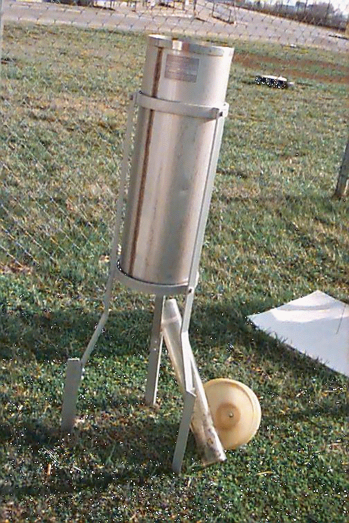
Standard 8-inch Rain Gage (Left). The funnel (normally located at the top of the gage) and measuring tube (normally inside the case below the funnel) are on the ground at the base of the gage. Fischer-Porter Recording Rain Gage (Right).
Most weather stations are equipped with the Standard 8-inch Rain Gage (pictured above on the left) to record daily precipitation. Others sites have recording rain gages such as the Fischer-Porter (pictured above on the right) to record rainfall amount as a function of time. Recording rain gage data make up the primary data input necessary for production of the Hourly Precipitation Data publication produced by NCDC.

Cotton Region Shelter
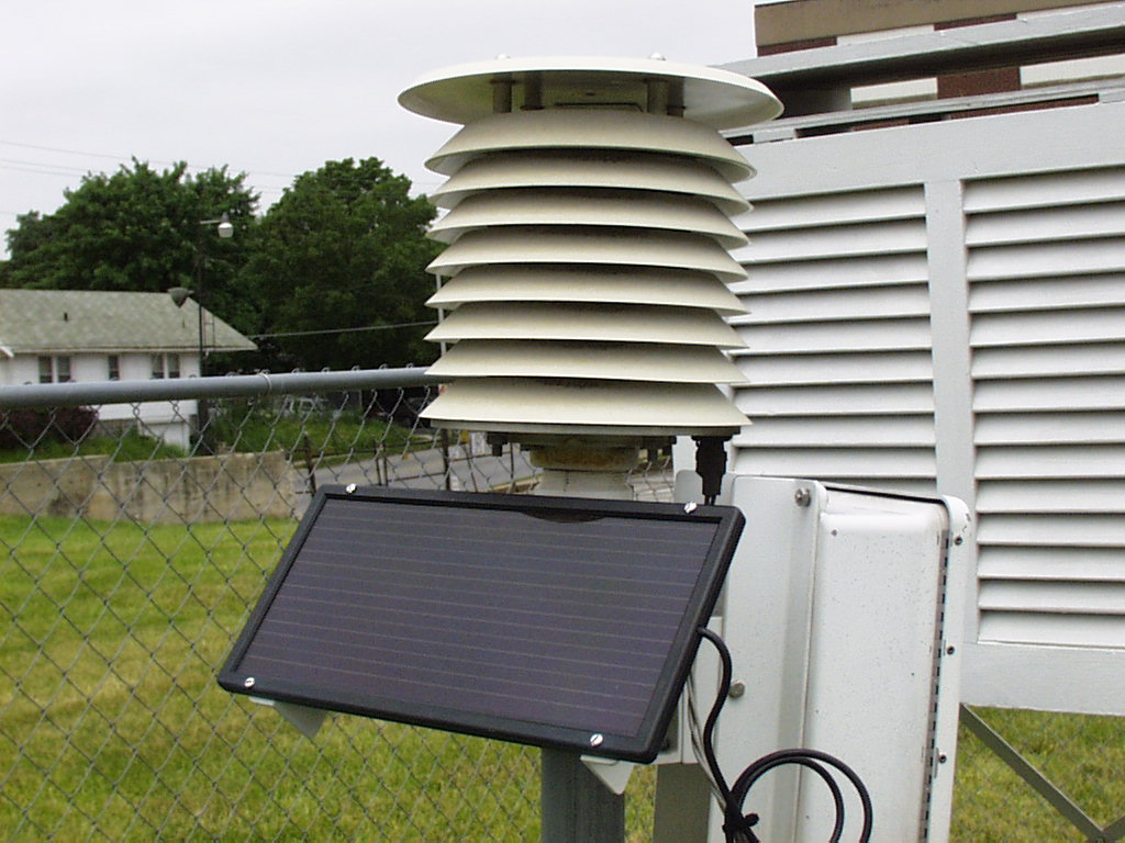
Station that take temperature observations use either the Cotton Region Shelter (pictured above) or Maximum/Minimum Temperature Systems (MMTS) (pictured below). The Cotton Region Shelter provides a shaded, well-ventilated area for maximum and minimum thermometers used to acquire daily temperature extremes. The MMTS electronically measures and memorizes the daily maximum and minimum temperatures. Daily highs and lows are recorded on forms which are processed by the National Climatic Data Center in Asheville, NC. Still other stations record a myriad of weather and climatic data use by both government and private user.

Maximum-Minimum Temperature System (foreground)
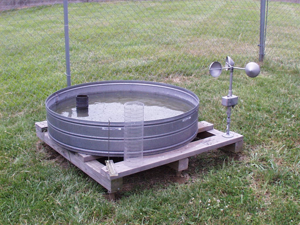
Some Stations have evaporation equipment to document moisture evaporation data used in both hydrology and agriculture.

Evaporation pan and associated equipment.
 |
Many observers take river and stream level reading to support the NWS hydrology forecast and warning programs. Water levels are measured using either a Staff Gage or a Wire Weight River Gage (shown at the left). |
At official NWS Cooperative Weather Stations observations are taken from instrumentation provided and maintained by the National Weather Service. Observations are taken at least once a day. Some stations provide data more often than others. Observations are recorded from instrument readings obtained at predetermined times to form a consistent weather picture that has occurred in the local area for a specific period, usually 24 hours. These recorded weather reports are documented on NWS forms and mailed by the observer to the NWS who forwards them to the National Climatic Data Center (NCDC) for processing. The Cooperative Weather Observer's data are also becoming more critical to operational decision made at the NWS office. With this fact in mind, the NWS is now in the midst of a program of near real time data acquisition known as Remote Observation System Automation or ROSA. When fully implemented, all data elements from Cooperative Weather Stations throughout the Nation will be electronically transmitted directly to the NWS where data will be ingested into forecasting models after appropriate quality control is applied to these data.
The information and pictures on this page are courtesy of the NWS Training Center