Overview
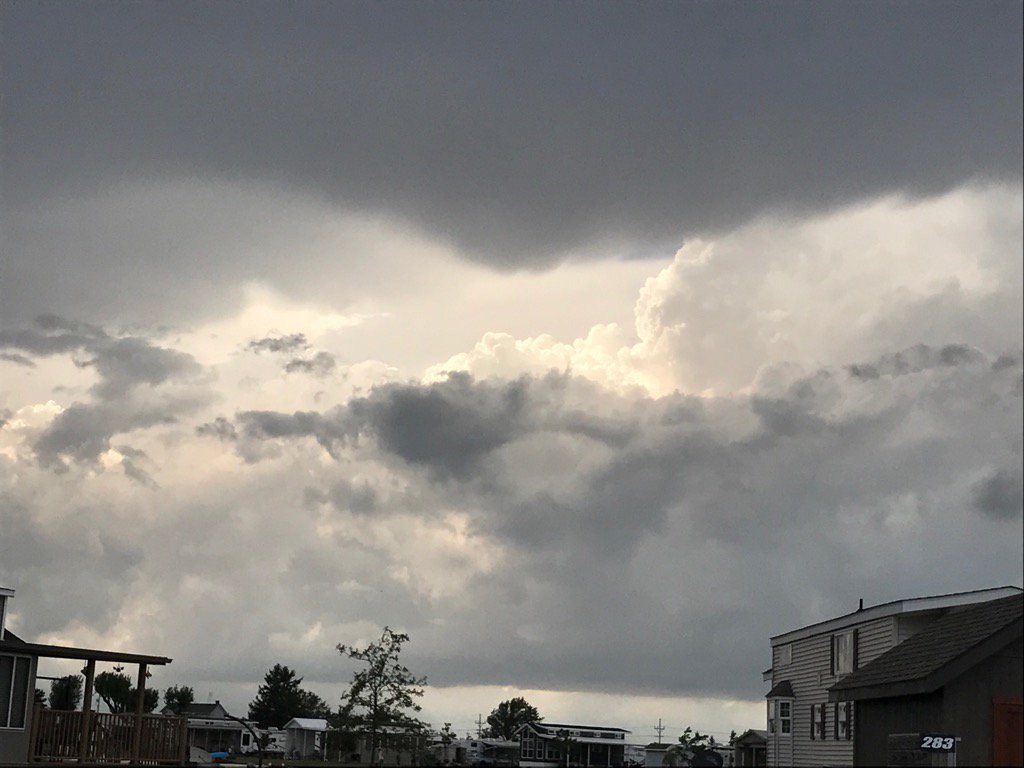
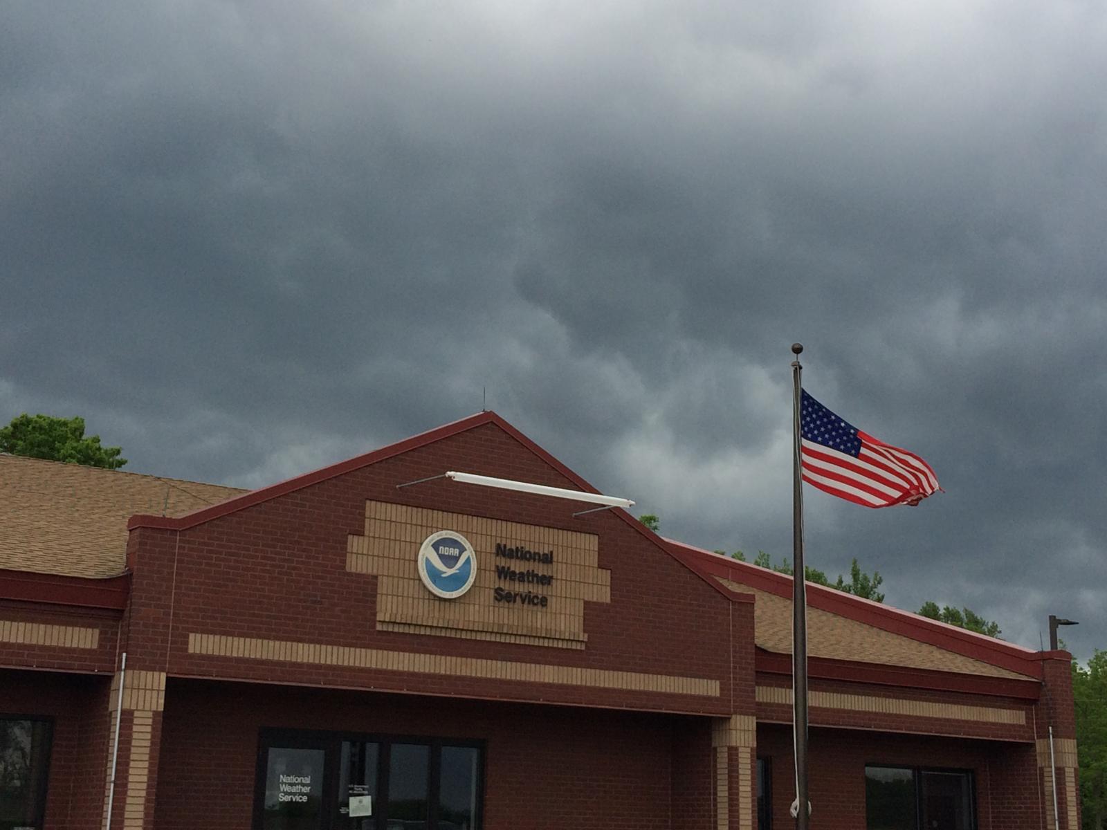
A cold front moved through the forecast area on the afternoon of May 28th, 2017. Strong to severe storms brought funnel clouds, gusty winds, and large hail to the region. Heavy rain from the thunderstorms led to flooding problems, especially in areas where heavy rainfall occurred earlier this week. While a funnel cloud was visible in a storm near North Manchester, we have not received any reports of damage (as of 10:15 pm EDT). If you saw hail of 1" or greater diameter or have wind damage, please send your report to the National Weather service using this form.
Below is a GOES-16 visible loop from 1830-1914Z (230-314 pm EDT) of the deep cumulonimbus clouds that developed along the surface warm front over northeast Indiana and northwest Ohio. Line of bubbling cloud oriented northwest to southeast denoted the position of the actual surface warm frontal boundary. A mesoscale sector was in place over the area with imagery taken every minute.
*NOTE* The GOES-16 data posted on this page are preliminary, non-operational data and are undergoing testing. Users bear all responsibility for inspecting the data prior to use and for the manner in which the data are utilized.
Tornado or Funnel Cloud?
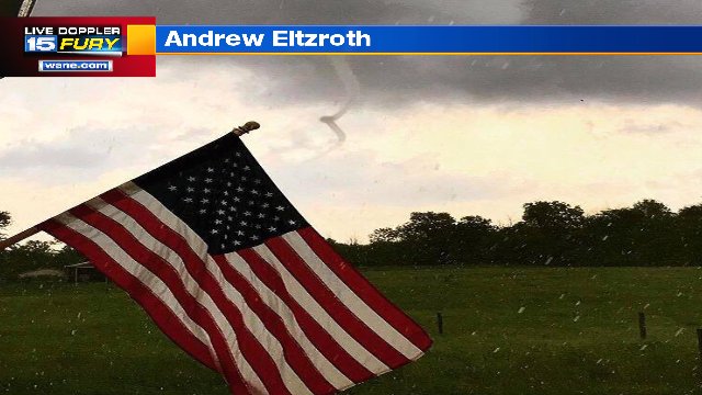
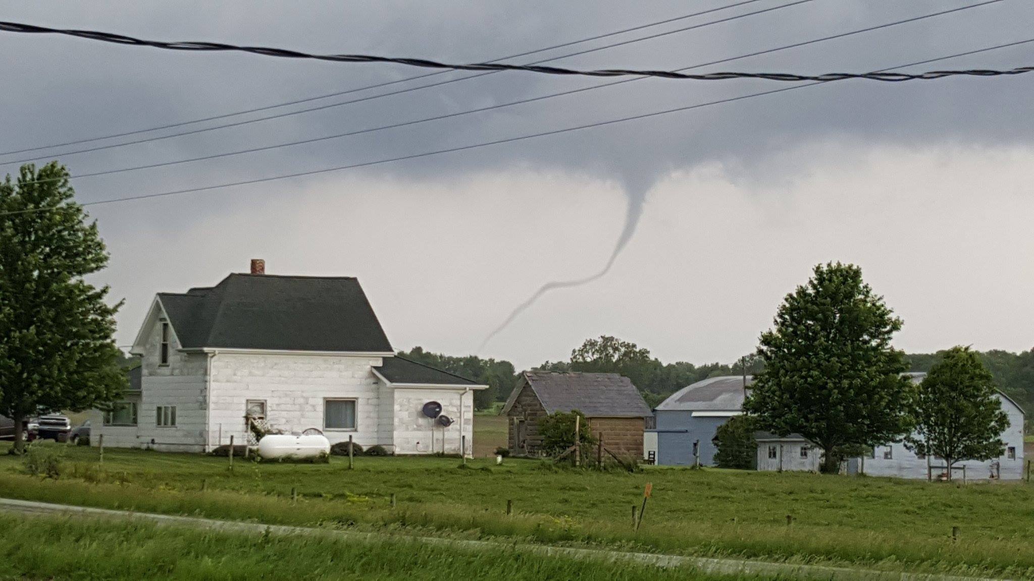
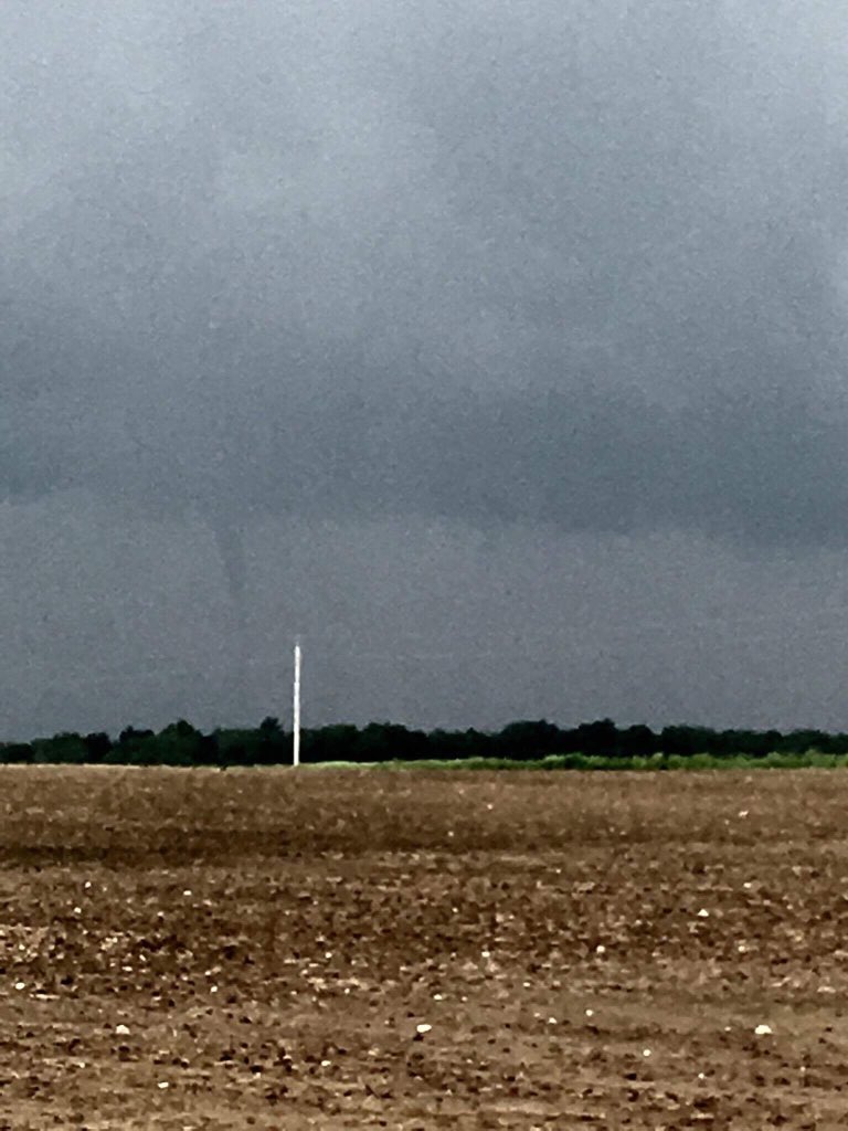
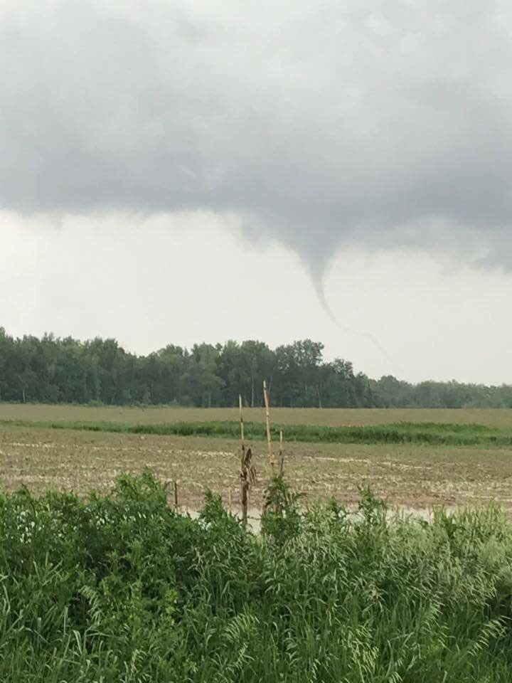
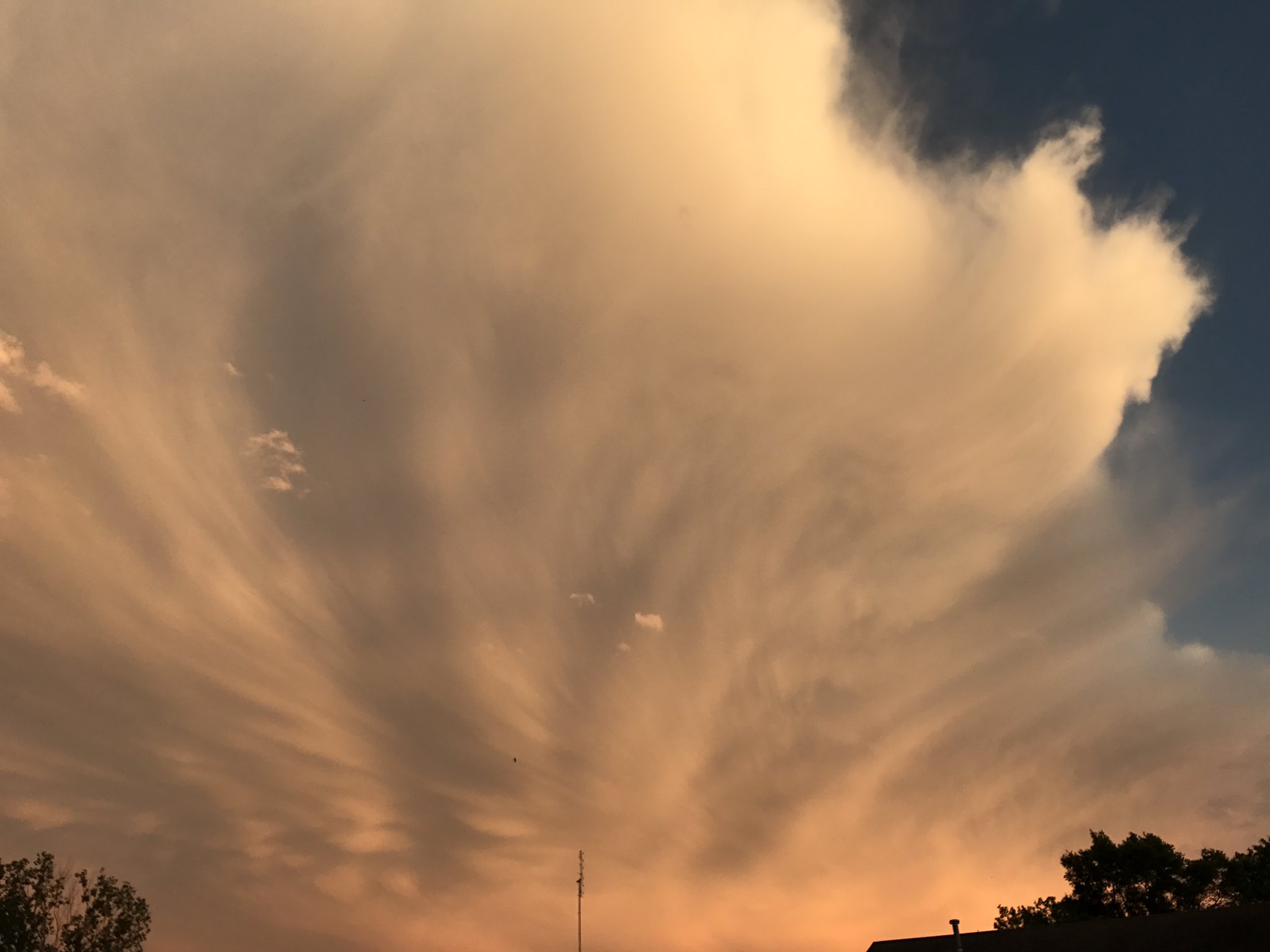
While we haven't received confirmation that a tornado touched down, it looks like the funnel cloud near North Manchester, IN was really close to being a tornado. These photos of the funnel were submitted to us through social media. This occurred around 4 pm EDT. There have been no reports of damage in this area as of 11:15 pm EDT 5/28. If you have any reports of damage, submit it to us using this form.
 |
 |
 |
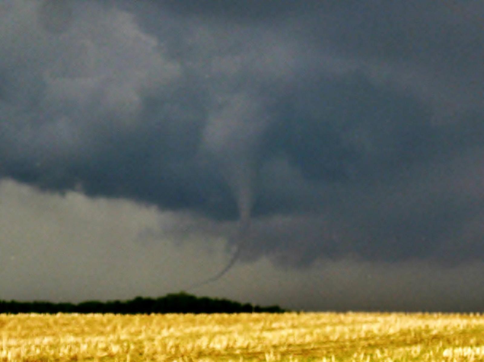 |
| Fig. 1: Funnel near North Manchester by Andrew Elzroth | Fig. 2: Funnel near North Manchester by David Fenker | Fig. 3: Funnel near North Manchester by Derek Hammontree | Fig. 4: Funnel near North Manchester by Josiah Maas |
 |
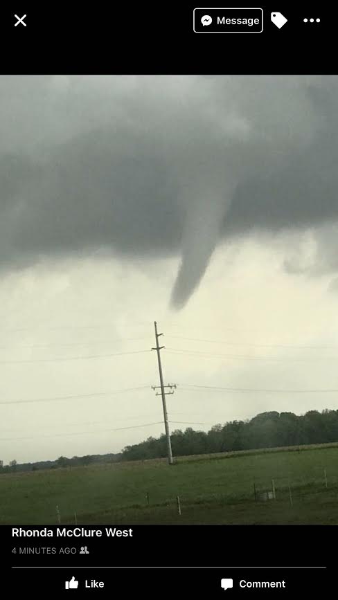 |
| Fig. 5: Funnel near North Manchester by Michael Geiger | Fig. 6: Funnel near North Manchester by Rhonda McClure |
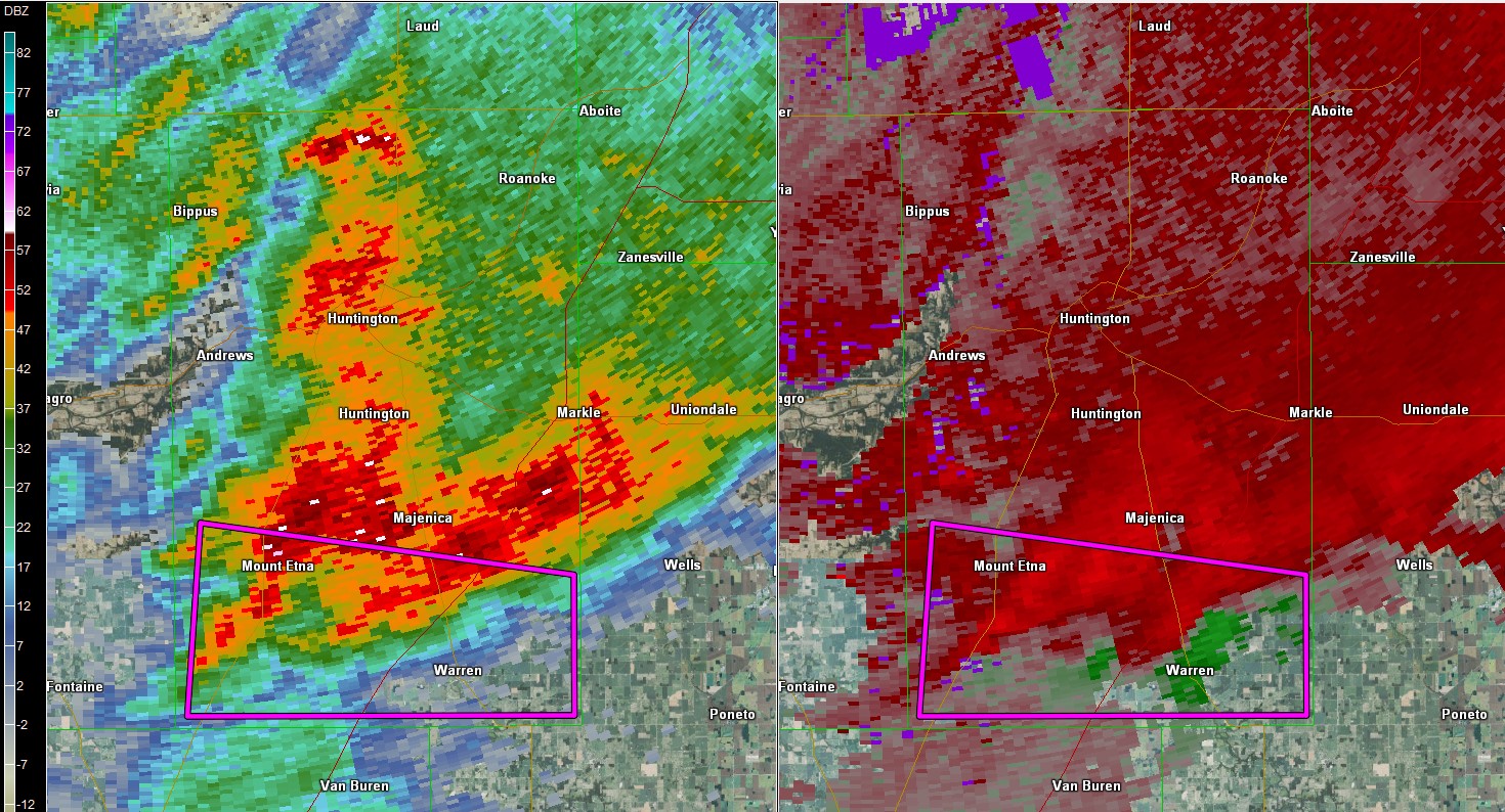
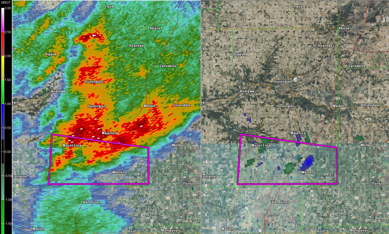
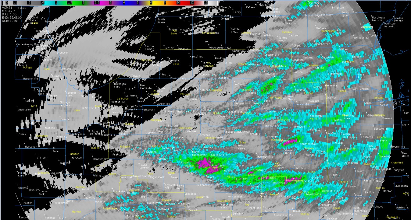
Later on in the evening around 7:30 PM EDT, a tornado warning was issued for southern Huntington County, IN. There were no reports of a tornado or even a funnel with this storm, however there was rotation observed on radar, as seen below. If you have any reports of damage, or if you saw a funnel cloud or tornado with this storm, submit it to us using the form.
 |
 |
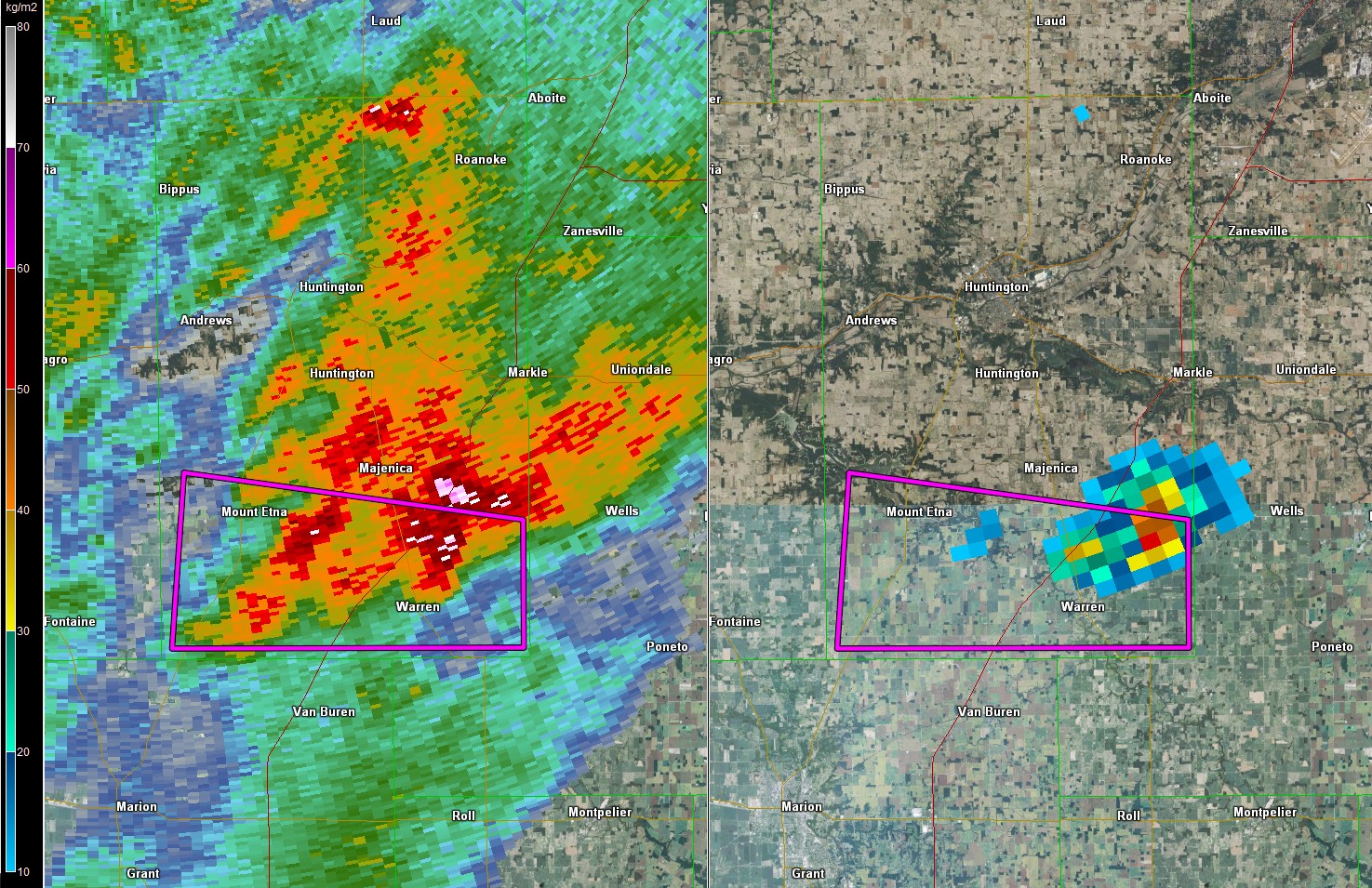 |
| Fig. 1: Storm that prompted the Tornado warning in Southern Huntington County, IN. Reflectivity and Velocity. Images captured using GR2 Analyst | Fig. 2: Storm that prompted the Tornado warning in Southern Huntington County, IN. Reflectivity and NROT. Shows rotation in the storm. Images captured using GR2 Analyst | Fig. 3: Storm that prompted the Tornado warning in Southern Huntington County, IN. Reflectivity and VIL. Shows the Hail core of the storm. Images captured using GR2 Analyst |
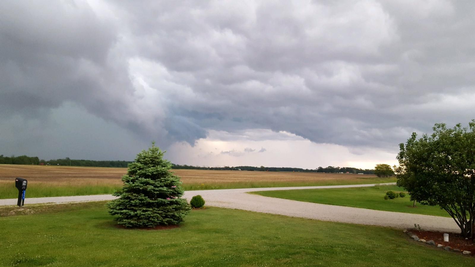
Wind & Hail:
Severe storms led to reports of strong to severe wind gusts and pea to just over quarter-sized hail. The largest hail report was ping pong ball size (1.5") near Hicksville, Ohio.
Wind
While there were no pictures of wind damage submitted to us as of 11:15 PM EDT May 28, 2017, we did receive several reports of 40-60 mph wind gusts.
 |
 |
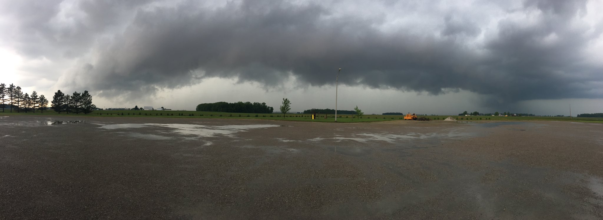 |
| Fig. 1: Shelf cloud near Warren from Doug Sparks | Fig. 2: Shelf cloud near Bluffton from John Tinney | Fig. 3: Shelf cloud on SR65 from Eric Harteis |
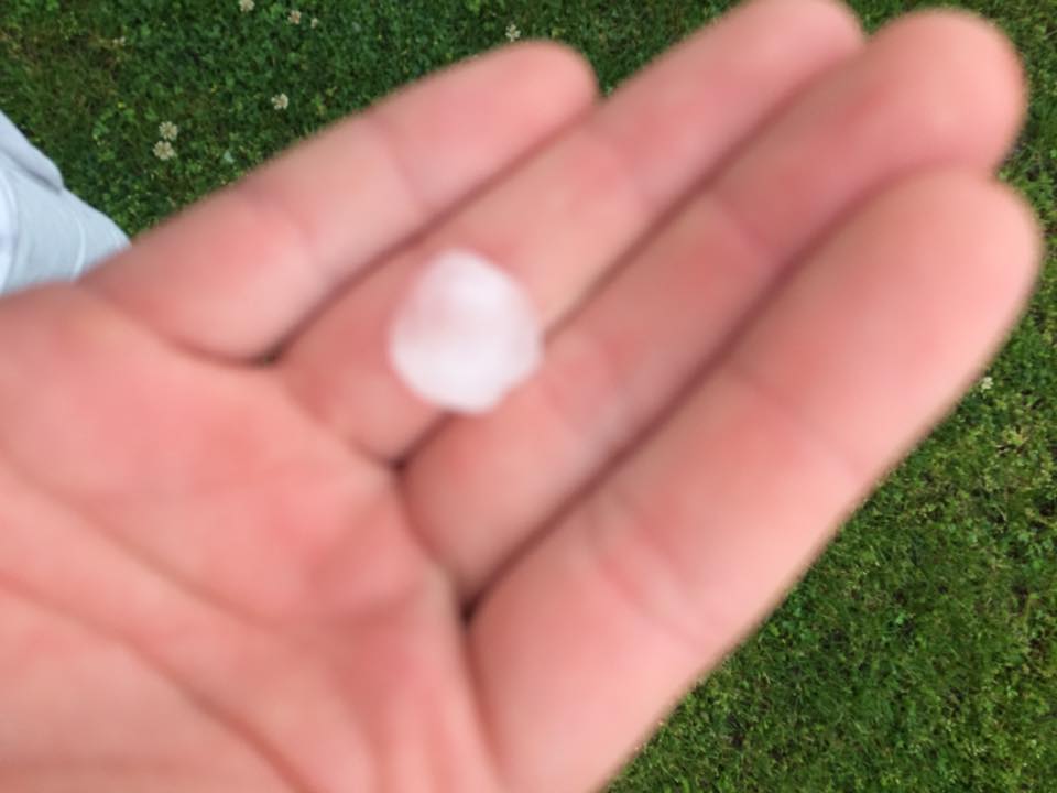
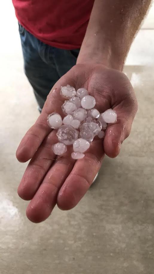
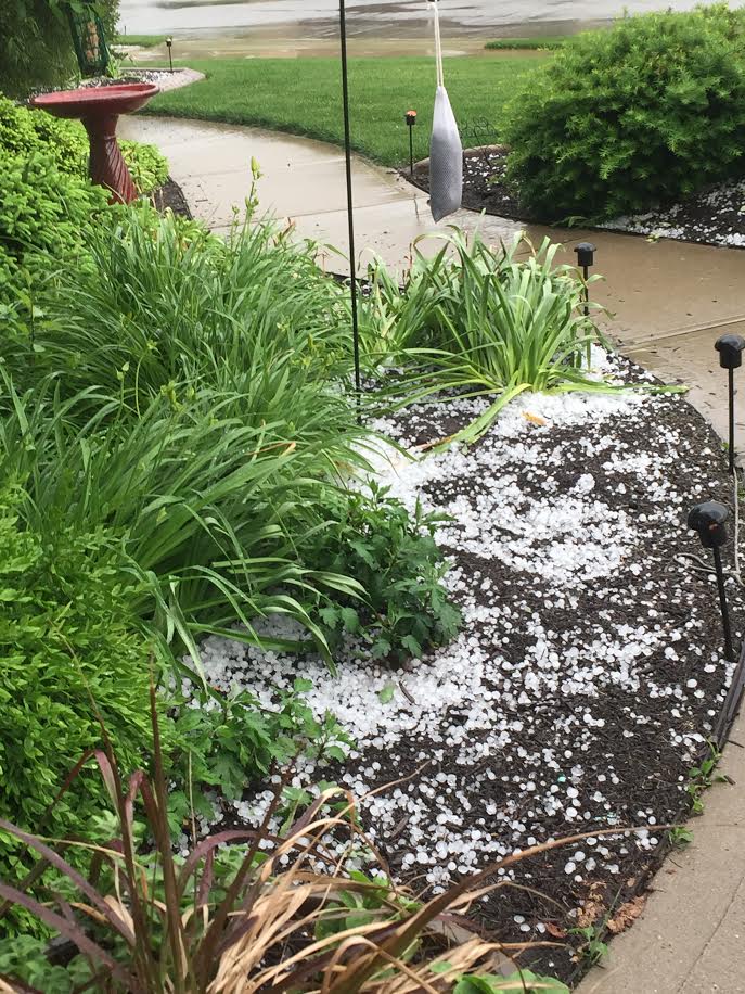
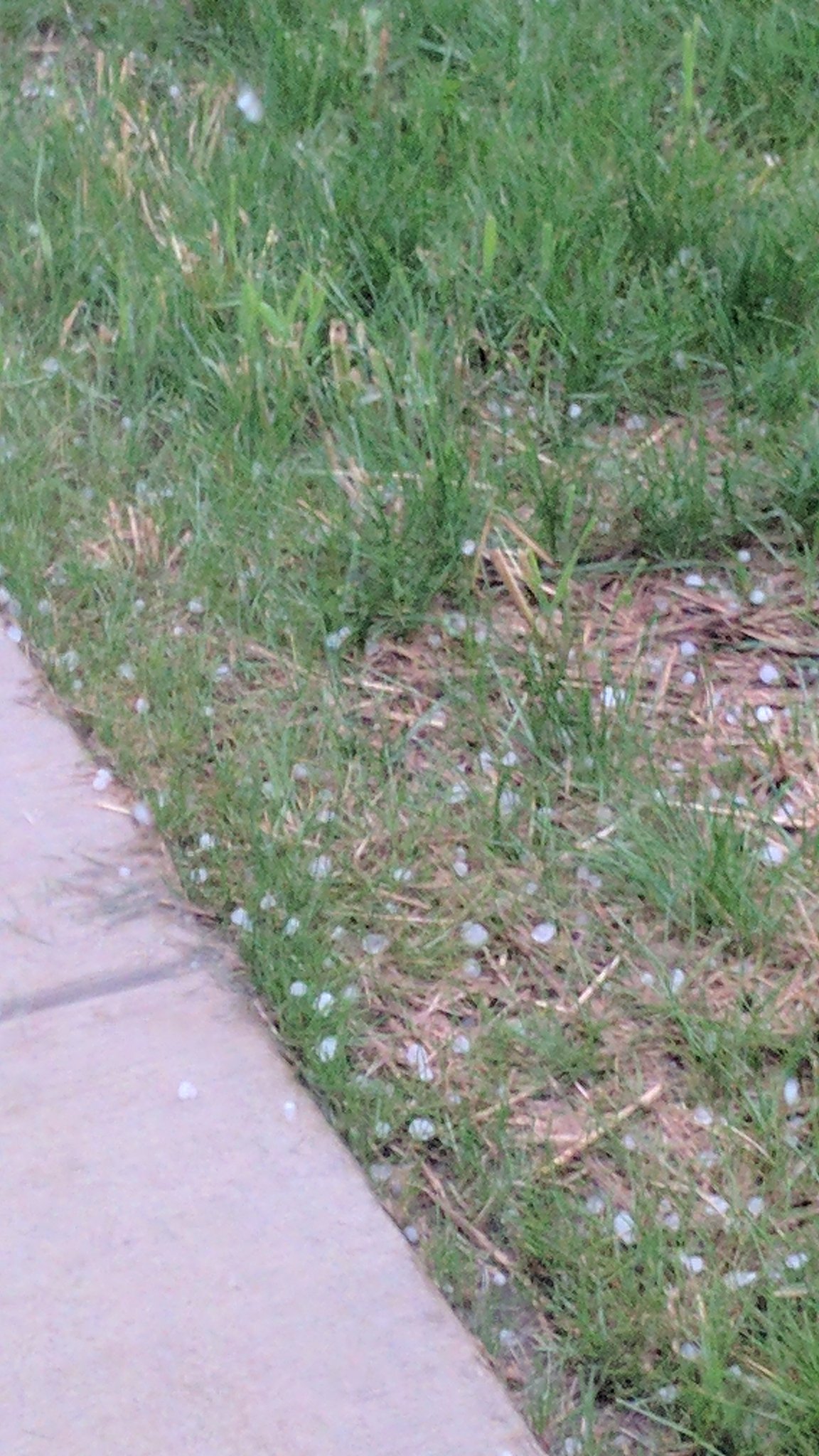
Hail
Hail reports of up to 1.5" in diameter occurred during this event. Here are some of the photos we received.
 |
 |
 |
 |
| Fig. 1: Dime Sized Hail. Photo by: Brandon Lee England | Fig. 2: Hail in Fort Wayne, IN. Photo by: Rod Hissong | Fig. 3: Hail in Fort Wayne, IN. Photo by: Rod Hissong | Fig. 4: Hail in Fort Wayne, IN. Photo by: Rod Hissong |
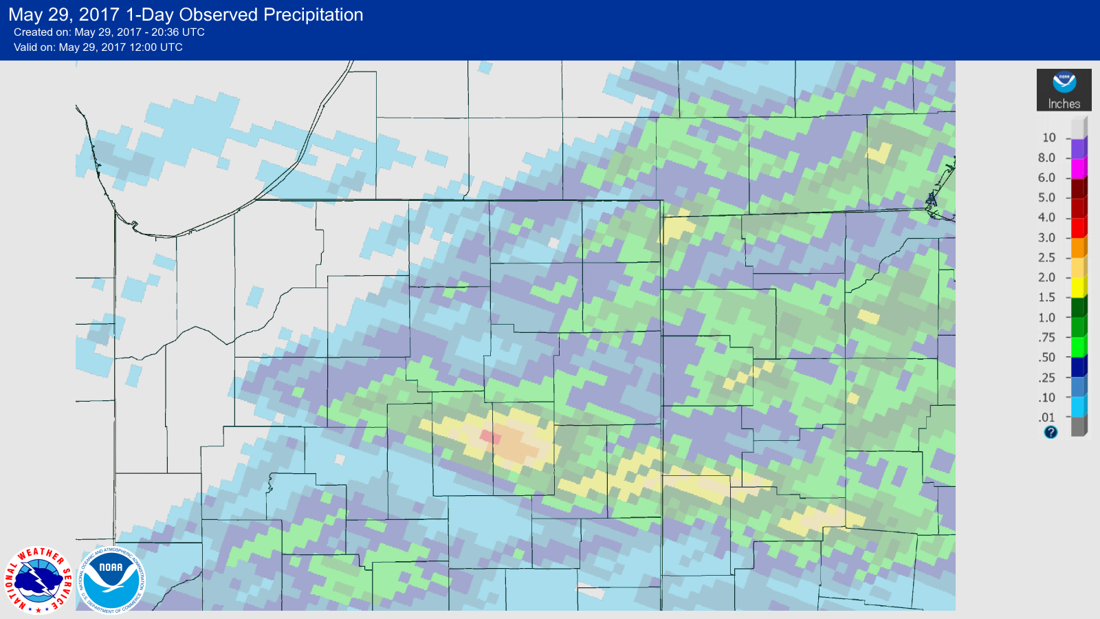
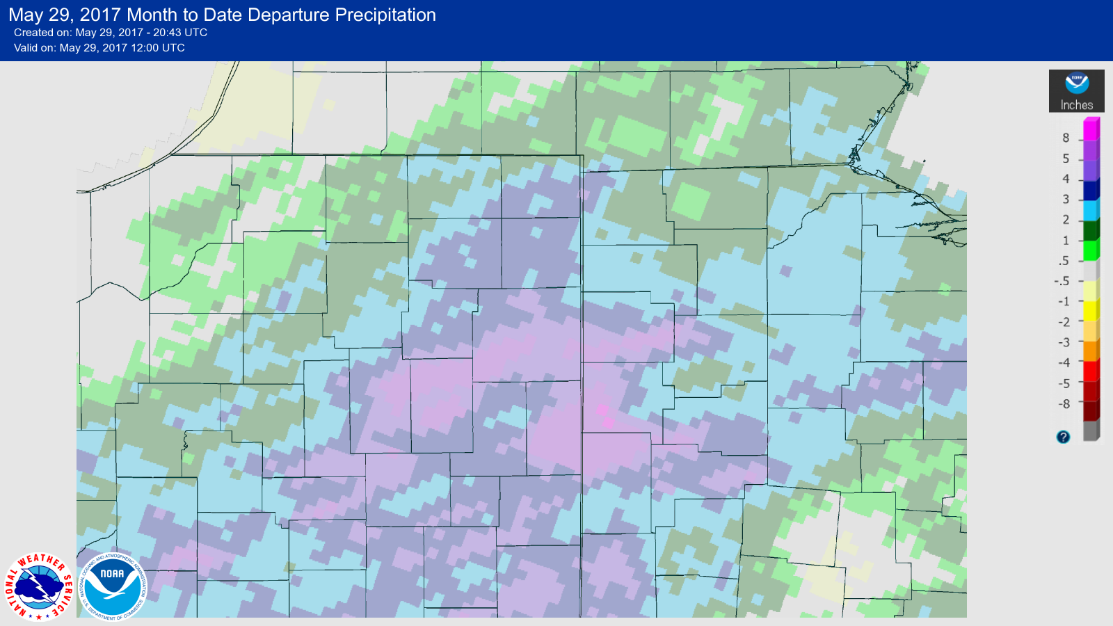
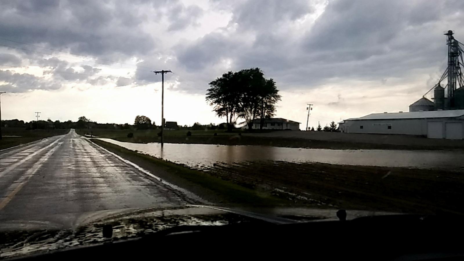
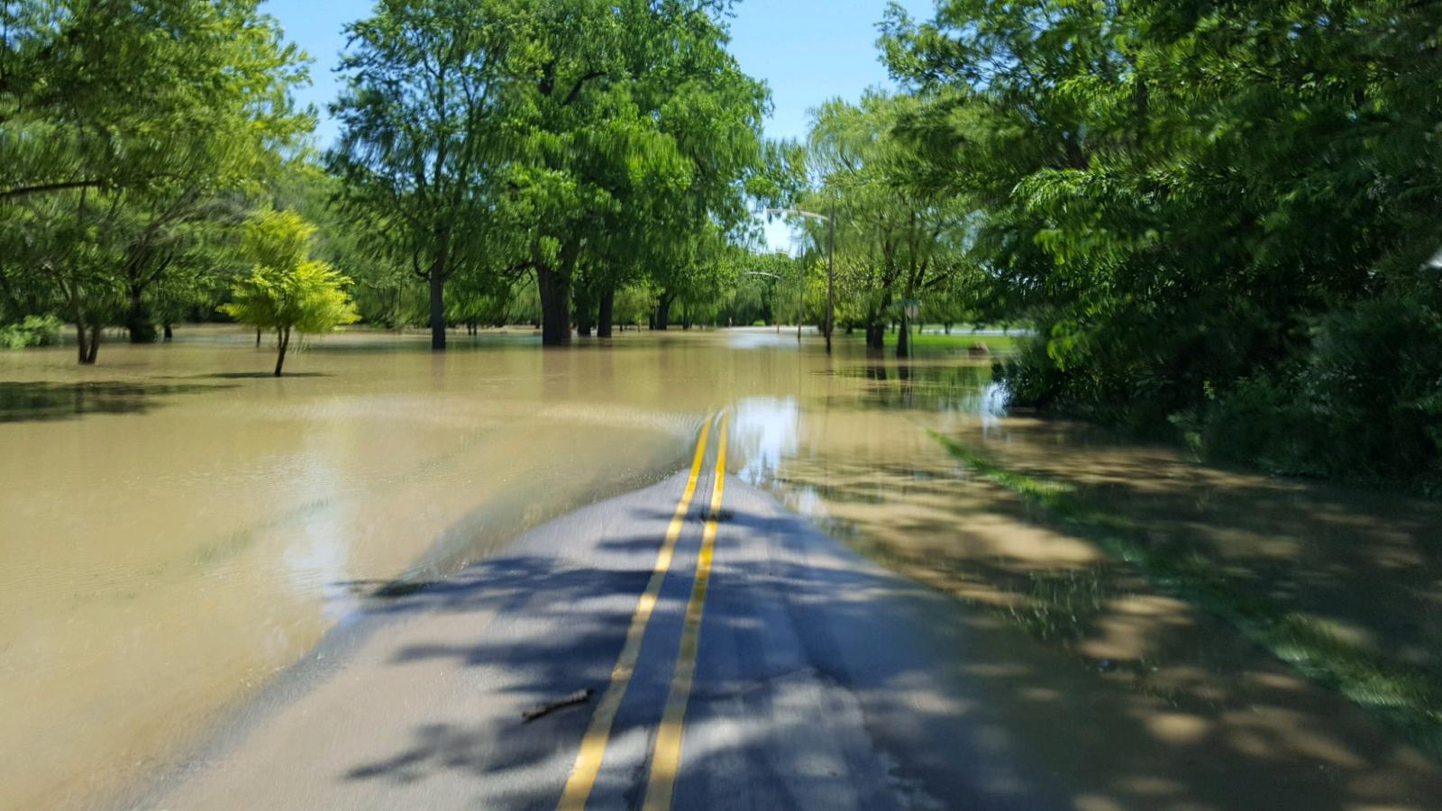
Flooding
Heavy rainfall from this event, combined with the excessive rain from the past month or so led to flooding. You can see in figures 3 and 4 that we are well above normal for May in many areas.
Above Normal Rainfall
 |
 |
 |
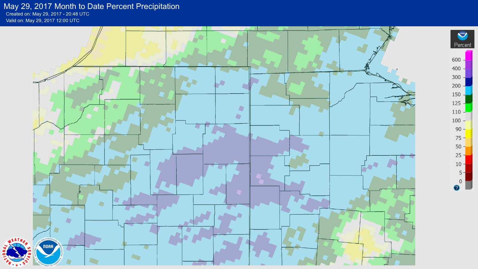 |
| Fig. 1. 24 hr Precipitation Map. Map created via the NWS AHPS page | Fig. 2. Total May Precipitation (Thru 5/29/17 AM). Map created via the NWS AHPS page | Fig. 3. May Precipitation (Thru 5/29/17 AM) departure from normal. Map created via the NWS AHPS page | Fig. 4. Percent of normal for May precipitation. Map created via the NWS AHPS page |
For specific rainfall amounts reported by instrumentation and observers, see the "rainfall" tab.
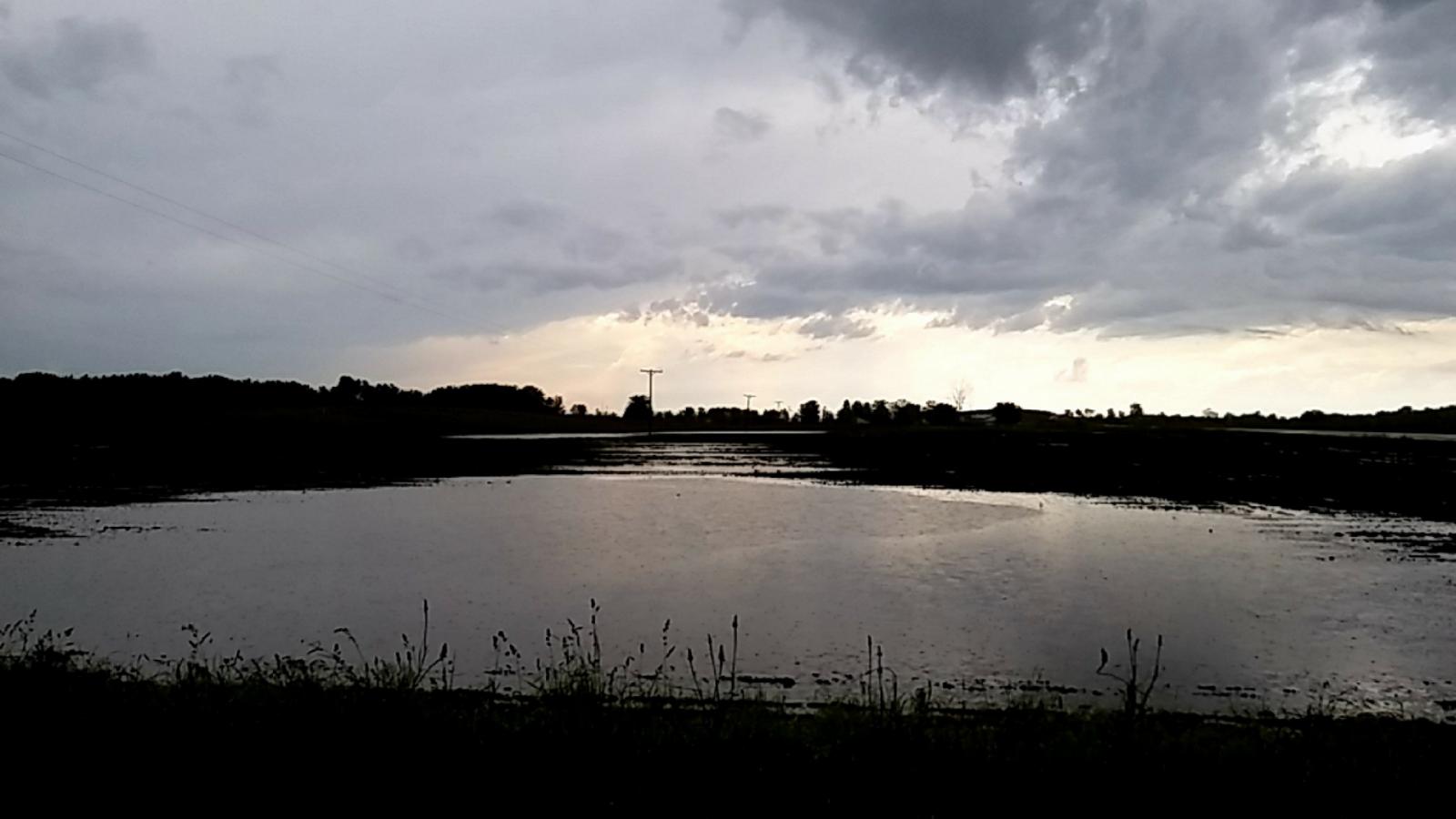
Flooding Photos
 |
 |
 |
| Figure 1. Flooding Near Adams, MI. Photo by Scott Taylor | Figure 2. Flooding Near Adams, MI. Photo by Scott Taylor | Figure 3. Flooding in Bluffton on Wabash Road near the Wabash River. Photo by Doug Sparks. |
Video
Tremendous street flooding in Liberty Center Ohio - video courtesy of Megan Bockelman.
Photos:
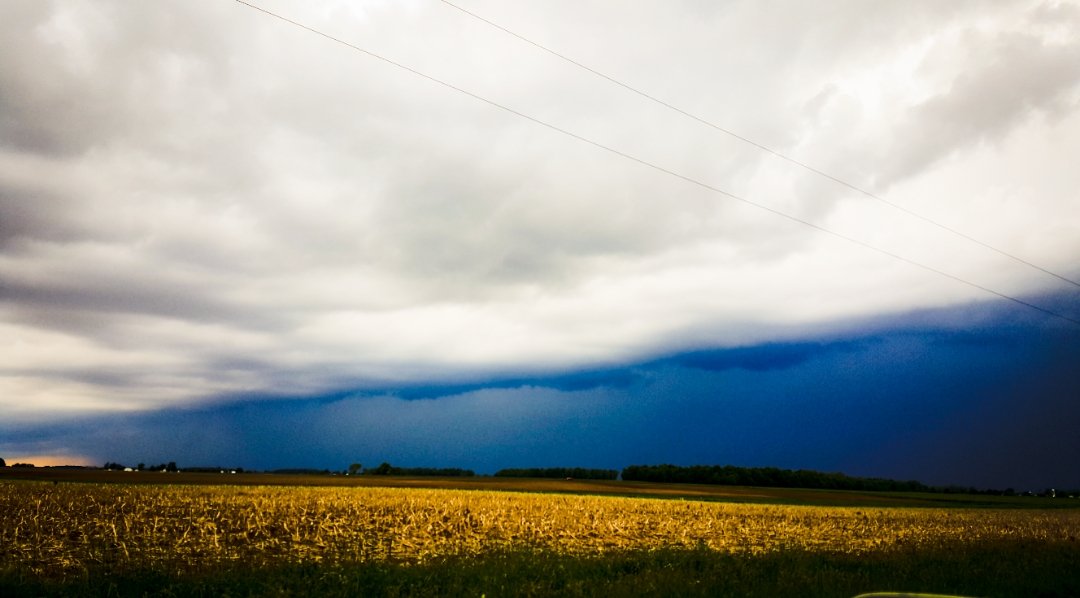
Thanks to those who submitted photos and video from the event. Below are additional photos we received.
 |
 |
 |
 |
| Photo: Abbot Carder | Photo: Chris Roller (IWX) | Photo: Dan Gadberry | Photo: Dan Gadberry |
 |
 |
 |
 |
| Photo: Dan Gadberry | Photo: Doug Sparks | Photo: Keith Hosman | Photo: Logan Gonya |
 |
 |
 |
|
| Photo: Logan Gonya | Photo: Megan Dodson (IWX) | Photo: Megan Dodson (IWX) | Photo: Rod Hissong |
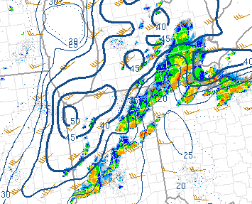
Radar:
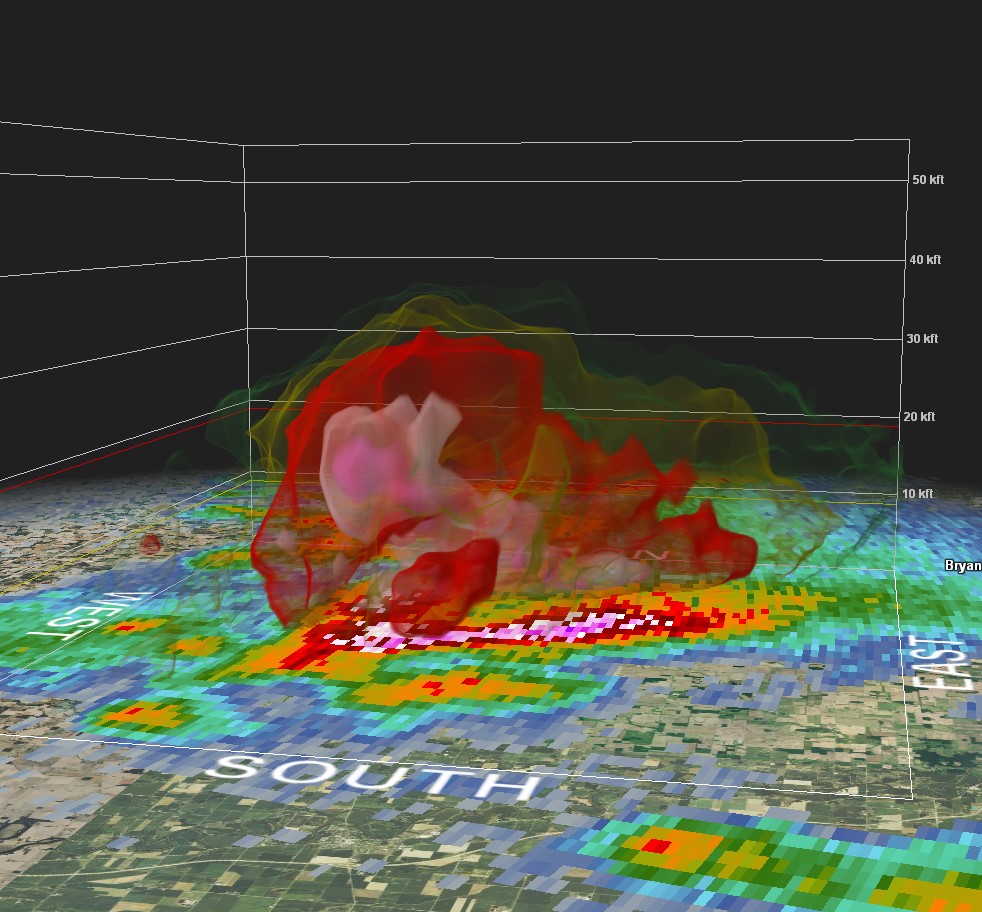
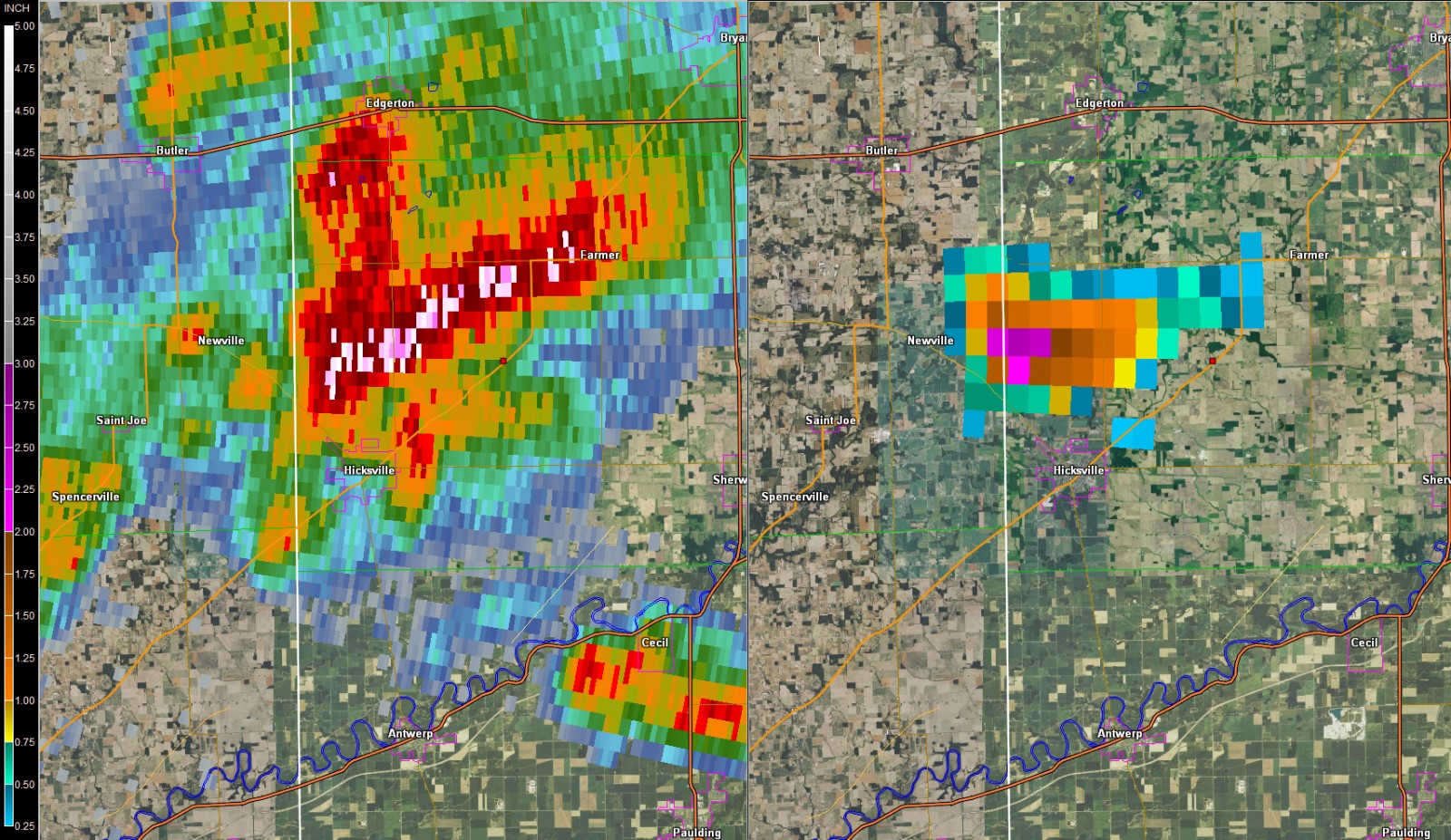
Below are a few of the radar images from the event. Figures 1 and 2 show the hail core in the storm near Hicksville, OH. Figure 3 shows the storm total precipitation from this event.
 |
 |
 |
| Fig. 1. 2:42 pm EDT 3-D Volumetric Radar Reflectivity Image near Hicksville Ohio. Note the pink to purple colors aloft indicating where the hail core was forming aloft around 20 thousand feet! Images captured using GR2 Analyst | Fig. 2. Two panel image showing 0.5 degree Reflectivity (left) and Maximum Estimated Hail Size (MESH, right). The purple colors indicated 2.5" hailstones. Hicksville, OH. Images captured using GR2 Analyst | Fig. 3. 12 hour Storm Total Rainfall ending at 1100 pm EDT. The purple colors denote 2-3" of rain that fell from these storms! Image captured from NWS AWIPS System. |
Storm Reports
PRELIMINARY LOCAL STORM REPORT...SUMMARY
NATIONAL WEATHER SERVICE NORTHERN INDIANA
928 PM EDT SUN MAY 28 2017

..TIME...   ...EVENT...      ...CITY LOCATION...     ...LAT.LON...
..DATE...   ....MAG....      ..COUNTY LOCATION..ST.. ...SOURCE....
            ..REMARKS..

0915 PM     HEAVY RAIN       FORT WAYNE              41.08N 85.14W
05/28/2017  M0.30 INCH       ALLEN              IN   PUBLIC

            0.30" IN 15-20 MINS.

0854 PM     HAIL             FORT WAYNE              41.07N 85.14W
05/28/2017  M1.00 INCH       ALLEN              IN   BROADCAST MEDIA


0837 PM     HAIL             1 SW FORT WAYNE         41.06N 85.15W
05/28/2017  E0.88 INCH       ALLEN              IN   PUBLIC


0829 PM     HEAVY RAIN       LAUD                    41.05N 85.45W
05/28/2017  E0.64 INCH       WHITLEY            IN   PUBLIC

            0.64" IN 10 MIN SPAN.

0825 PM     HAIL             1 N FORT WAYNE          41.08N 85.14W
05/28/2017  M0.25 INCH       ALLEN              IN   PUBLIC

            PEA SIZED HAIL COVERING THE ROAD.

0727 PM     HAIL             2 WNW MAJENICA          40.78N 85.49W
05/28/2017  M0.75 INCH       HUNTINGTON         IN   TRAINED SPOTTER


0705 PM     FLOOD            1 NW BOWERSTOWN         40.90N 85.45W
05/28/2017                   HUNTINGTON         IN   EMERGENCY MNGR

            WESTBOUND DRIVING LANE BLOCKED BY WATER.

0654 PM     HAIL             OTTAWA                  41.02N 84.04W
05/28/2017  E0.88 INCH       PUTNAM             OH   TRAINED SPOTTER

            ESTIMATED NICKLE-SIZED HAIL IN OTTAWA. WINDS
            WERE ESTIMATED ABOUT 50 MPH. HEAVY RAIN WAS
            CAUSING A LOT OF PONDING OF WATER ON THE
            ROADS.

0654 PM     HAIL             3 N LINCOLNVILLE        40.80N 85.67W
05/28/2017  M1.00 INCH       WABASH             IN   TRAINED SPOTTER
0630 PM     HAIL             2 SSE WABASH            40.77N 85.81W
05/28/2017  M1.00 INCH       WABASH             IN   TRAINED SPOTTER

            REPORTED A FULL RANGE OF HAIL BETWEEN PEA
            SIZED ALL THE WAY UP TO QUARTER SIZED.
            DELAYED REPORT.
0625 PM     HAIL             SPENCERVILLE            40.71N 84.35W
05/28/2017  M0.25 INCH       ALLEN              OH   PUBLIC


0601 PM     HAIL             2 SSW ANDREWS           40.83N 85.62W
05/28/2017  M0.25 INCH       HUNTINGTON         IN   TRAINED SPOTTER


0535 PM     HAIL             OHIO CITY               40.77N 84.61W
05/28/2017  E0.50 INCH       VAN WERT           OH   BROADCAST MEDIA


0453 PM     FLOOD            3 SE BIPPUS             40.92N 85.57W
05/28/2017                   HUNTINGTON         IN   PUBLIC

            WATER ACROSS ROADWAY ON SR16 IMMEDIATELY
            WEST OF SR105. WATER RISING.

0448 PM     TSTM WND GST     1 E OAKSHADE            41.67N 84.13W
05/28/2017  M60 MPH          FULTON             OH   TRAINED SPOTTER


0439 PM     TSTM WND GST     3 N TEDROW              41.65N 84.21W
05/28/2017  E60 MPH          FULTON             OH   PUBLIC


0430 PM     HEAVY RAIN       2 NE BRUNERSBURG        41.32N 84.37W
05/28/2017  E1.20 INCH       DEFIANCE           OH   PUBLIC

            EVENT TOTAL.

0426 PM     FLOOD            FARMER                  41.38N 84.63W
05/28/2017                   DEFIANCE           OH   TRAINED SPOTTER

            FIELDS UNDER WATER.

0412 PM     FLOOD            2 SSE MONTPELIER        41.56N 84.59W
05/28/2017                   WILLIAMS           OH   FIRE DEPT/RESCUE

            WATER UP TO 2 FT OVER INTERSECTION OF CR 6
            AND US 20.

0405 PM     FLOOD            2 SE NAPOLEON           41.37N 84.10W
05/28/2017                   HENRY              OH   EMERGENCY MNGR

            INCH OF WATER COVERING ALL OF NEARBY FIELDS.

0402 PM     HAIL             4 S NAPOLEON            41.34N 84.12W
05/28/2017  E0.25 INCH       HENRY              OH   PUBLIC


0359 PM     FUNNEL CLOUD     1 NNW BRACKEN           41.00N 85.64W
05/28/2017                   HUNTINGTON         IN   PUBLIC

            AS INDICATED BY PICTURES/VIDEOS AND PUBLIC
            REPORTS.

0356 PM     TSTM WND GST     NAPOLEON                41.39N 84.13W
05/28/2017  M60 MPH          HENRY              OH   PUBLIC


0355 PM     HAIL             2 W NORTH MANCHESTER    41.01N 85.80W
05/28/2017  M0.25 INCH       WABASH             IN   PUBLIC


0338 PM     HAIL             1 WNW LISBON            41.42N 85.28W
05/28/2017  E0.75 INCH       NOBLE              IN   TRAINED SPOTTER

            DIME SIZED HAIL NEAR KENDALLVILLE.

0337 PM     HEAVY RAIN       3 NW BRUNERSBURG        41.33N 84.43W
05/28/2017  E1.50 INCH       DEFIANCE           OH   PUBLIC

            1.5 INCH RAIN IN 45 MINS.

0335 PM     FLOOD            3 NNE BRUNERSBURG       41.35N 84.36W
05/28/2017                   DEFIANCE           OH   PUBLIC

            STANDING WATER IN FIELDS.

0325 PM     HAIL             3 NW BRUNERSBURG        41.34N 84.44W
05/28/2017  M1.00 INCH       DEFIANCE           OH   PUBLIC


0320 PM     HAIL             4 NE THE BEND           41.33N 84.47W
05/28/2017  E0.75 INCH       DEFIANCE           OH   TRAINED SPOTTER


0318 PM     HAIL             2 N NEY                 41.41N 84.52W
05/28/2017  M1.00 INCH       DEFIANCE           OH   TRAINED SPOTTER


0304 PM     HAIL             4 N HICKSVILLE          41.35N 84.77W
05/28/2017  M1.50 INCH       DEFIANCE           OH   TRAINED SPOTTER


0250 PM     HAIL             1 W ROCHESTER           41.06N 86.22W
05/28/2017  E0.50 INCH       FULTON             IN   TRAINED SPOTTER


0235 PM     HAIL             4 N HICKSVILLE          41.35N 84.77W
05/28/2017  M1.00 INCH       DEFIANCE           OH   TRAINED SPOTTER
Rain Reports
Public Information Statement
National Weather Service Northern Indiana
439 PM EDT Mon May 29 2017

...24 Hour Rainfall Reports For May 28th 2017...

Location                     Amount    Time/Date       Lat/Lon

...Indiana...

...Adams County...
Linn Grove                   1.15 in   0645 AM 05/29   40.66N/85.03W

...Allen County...
Rolling Hills                0.35 in   0703 AM 05/29   41.03N/85.29W
2 WSW Maples                 0.33 in   0700 AM 05/29   40.99N/85.00W
Woodburn 3n                  0.23 in   0700 AM 05/29   41.16N/84.85W

...Blackford County...
(kc9dcr)hartford City 0.3 SS 0.28 in   0700 AM 05/29   40.45N/85.37W
Hartford City                0.27 in   0700 AM 05/29   40.45N/85.37W

...De Kalb County...
Garrett                      0.78 in   0700 AM 05/29   41.34N/85.13W
Auburn                       0.25 in   0600 AM 05/29   41.37N/85.05W

...Grant County...
Fairmount                    0.22 in   0700 AM 05/29   40.42N/85.64W

...Huntington County...
3 NE Majenica                2.05 in   0713 AM 05/29   40.82N/85.41W
1 ENE Bowerstown             1.08 in   0700 AM 05/29   40.90N/85.41W
2 NW Warren                  0.61 in   0645 AM 05/29   40.71N/85.45W

...Miami County...
1 WNW Deedsville             0.70 in   0700 AM 05/29   40.92N/86.12W

...Noble County...
2 E Rome City                0.26 in   0700 AM 05/29   41.50N/85.31W

...Steuben County...
Angola                       0.62 in   0700 AM 05/29   41.64N/84.99W
Metz                         0.46 in   0700 AM 05/29   41.61N/84.84W
1 E Hamilton                 0.45 in   0700 AM 05/29   41.53N/84.89W
1 W Golden Lake              0.33 in   0700 AM 05/29   41.60N/85.09W
1 S Angola                   0.33 in   0600 AM 05/29   41.62N/85.00W
2 WSW Golden Lake            0.27 in   0700 AM 05/29   41.59N/85.10W
2 ENE Crooked Lake           0.22 in   0600 AM 05/29   41.70N/84.99W

...Wabash County...
Wabash                       0.53 in   0600 AM 05/29   40.80N/85.83W

...Wells County...
Bluffton                     1.10 in   0645 AM 05/29   40.74N/85.17W

...Michigan...

...Hillsdale County...
Litchfield                   0.64 in   0630 AM 05/29   42.05N/84.75W

...Ohio...

...Allen County...
Lima                         1.14 in   0730 AM 05/29   40.73N/84.12W
Bluffton                     0.77 in   0715 AM 05/29   40.89N/83.89W
1 SSW Elida                  0.43 in   0724 AM 05/29   40.76N/84.21W

...Defiance County...
Defiance 9.4 NE              0.72 in   0600 AM 05/29   41.38N/84.24W

...Fulton County...
1 NE Tedrow                  0.30 in   0728 AM 05/29   41.62N/84.19W

...Henry County...
3 SE Mcclure                 1.39 in   0700 AM 05/29   41.33N/83.91W
Gallup                       0.27 in   0700 AM 05/29   41.46N/84.15W

...Paulding County...
1 NW Oakwood                 2.10 in   0712 AM 05/29   41.11N/84.40W
3 SW Charloe                 0.39 in   0714 AM 05/29   41.10N/84.48W

...Putnam County...
Kalida                       0.39 in   0710 AM 05/29   40.98N/84.20W

...Van Wert County...
2 WNW Convoy                 0.24 in   0716 AM 05/29   40.93N/84.74W
1 ENE Van Wert               0.24 in   0717 AM 05/29   40.87N/84.56W

...Williams County...
1 WSW Bryan                  0.26 in   0709 AM 05/29   41.46N/84.57W
Environment
There are 3 ingredients needed to develop thunderstorms: Moisture, Instability, and Lift. To make those storms severe, wind shear is needed. On May 28th, 2017 a cold front moved through our forecast area during the afternoon and early evening hours. This provided the lift. We also had sufficient moisture transport ahead of the front, with precipitable water values up to around 1 inch or so. Instability and wind shear were also present, with about 1500 J/kg of surface based CAPE and 35-40 knots of shear.
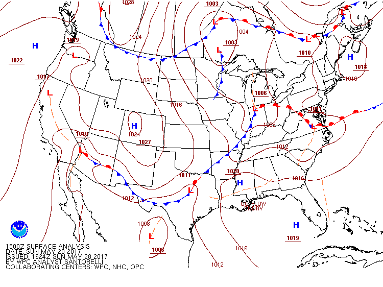
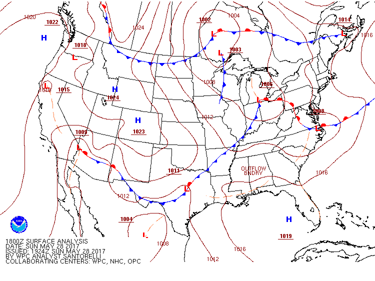
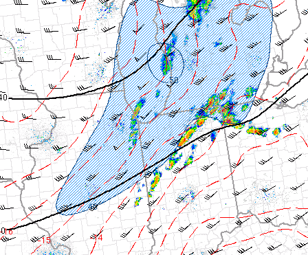
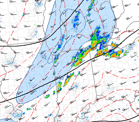
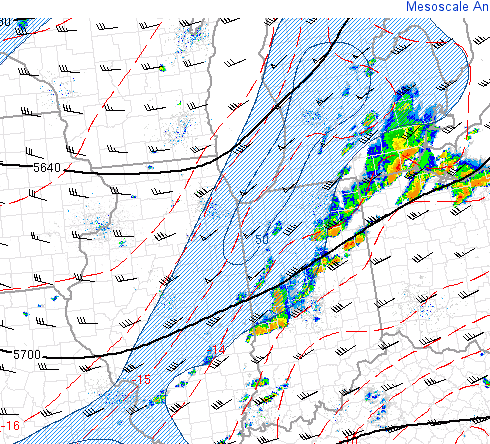
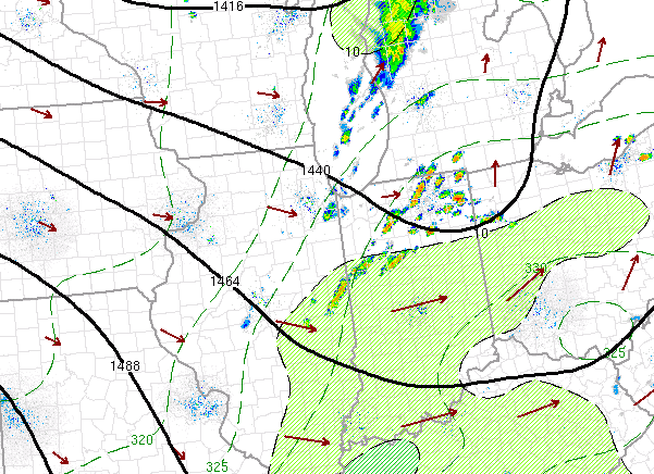
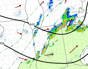
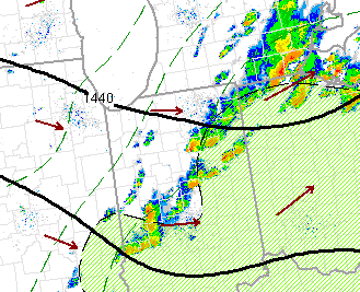
Surface Weather Maps
A cold front is shown moving through the forecast area during the day/evening on May 28th, 2017 (Fig. 1-3). Additionally, at 300 MB we see a Jet streak, which led to additional upper level support for storms (Fig. 4-6). In the mid levels, an upper level trough was approaching the region.
 |
 |
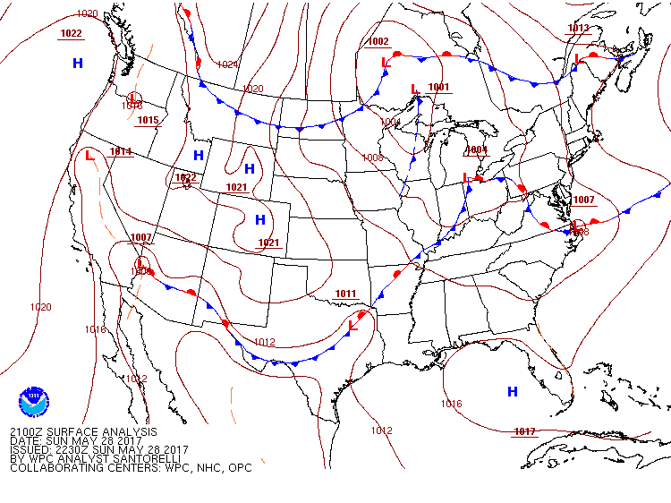 |
| Figure 1: 10 AM EDT Surface Analsyis (WPC) | Figure 2: 2 PM EDT Surface Analsyis (WPC) | Figure 3: 5 PM EDT Surface Analsyis (WPC) |
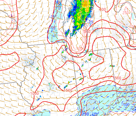
Lift
Upper level divergence was present from the Jet at 300 mb, mid level support from the wave moving through the area (500mb).
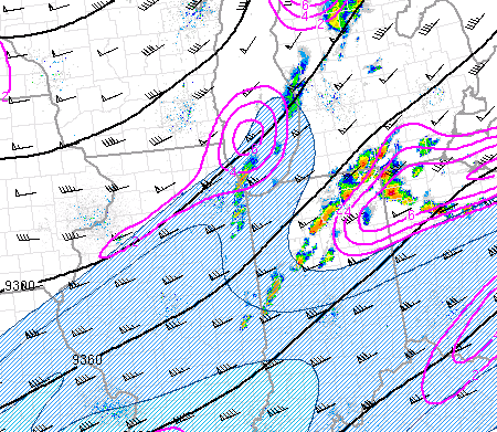 |
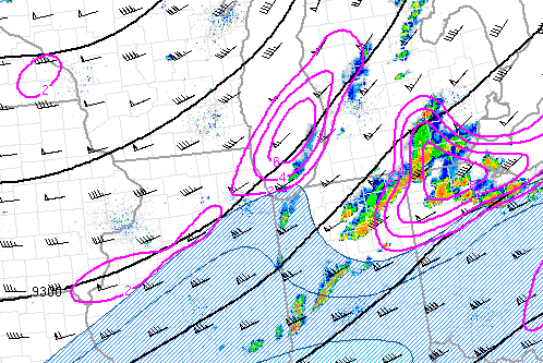 |
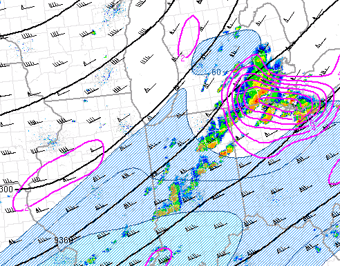 |
| Figure 4: 3 PM EDT 300mb Analysis (SPC) | Figure 5: 4 PM EDT 300mb Analysis (SPC) | Figure 6: 5 PM EDT 300mb Analysis (SPC) |
 |
 |
 |
| Figure 7: 3 PM EDT 500mb Analysis (SPC) | Figure 8: 4 PM EDT 500mb Analysis (SPC) | Figure 9: 5 PM EDT 500mb Analysis (SPC) |
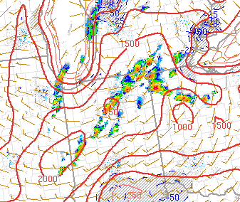
Instability and Wind Shear
Instability was present when the front arrived, which made it easy for storms to develop. Wind Shear was also present, as seen in figure 6.
 |
 |
 |
| Figure 4: SFC CAPE (J/kg) at 1 pm EDT (SPC) | Figure 5: SFC CAPE (J/kg) at 3 pm EDT (SPC) | Figure 6: Wind Shear (knots) (SPC) |
Moisture
Moisture was also present, as shown in the images below. Precipitable water values were around 1 inch.
 |
 |
 |
| Figure 7: Moisture Transport 2 pm EDT (SPC) | Figure 8: Moisture Transport 4 pm EDT (SPC) | Figure 9: Moisture Transport 5 pm EDT (SPC) |
 |
Media use of NWS Web News Stories is encouraged! Please acknowledge the NWS as the source of any news information accessed from this site. |
|

