
Thunderstorms developed during the late afternoon on Sunday March 27, 2016 east of a line from Logansport, IN to Three Rivers, MI and continued into the evening hours, leading to severe hail.
Below is a map of storm reports across the area. Individual reports are listed below. Do you have damage/hail reports from this event that are not listed below (hail 1" or greater only please)? Send us your report here-we're looking for reports from southern Jay County.

PRELIMINARY LOCAL STORM REPORT...SUMMARY
NATIONAL WEATHER SERVICE NORTHERN INDIANA
947 PM EDT SUN MAR 27 2016
..TIME... ...EVENT... ...CITY LOCATION... ...LAT.LON...
..DATE... ....MAG.... ..COUNTY LOCATION..ST.. ...SOURCE....
..REMARKS..
0840 PM HAIL MCCLURE 41.37N 83.94W
03/27/2016 M0.88 INCH HENRY OH TRAINED SPOTTER
DIME TO NICKLE SIZED HAIL.
0838 PM HAIL OAKWOOD 41.10N 84.38W
03/27/2016 E0.88 INCH PAULDING OH TRAINED SPOTTER
0820 PM HAIL HAMLER 41.23N 84.03W
03/27/2016 M0.88 INCH HENRY OH TRAINED SPOTTER
DIME TO NICKLE SIZED HAIL.
0815 PM HAIL HOLGATE 41.25N 84.13W
03/27/2016 M0.88 INCH HENRY OH FIRE DEPT/RESCUE
0800 PM HAIL BRYAN 41.47N 84.55W
03/27/2016 M0.50 INCH WILLIAMS OH AMATEUR RADIO
0.25-0.50 INCH HAIL.
0740 PM HAIL LATTY 41.09N 84.58W
03/27/2016 E1.00 INCH PAULDING OH PUBLIC
ESTIMATED NICKLE TO QUARTER SIZED HAIL FROM
PICTURES.
0730 PM HAIL 2 SSE MAPLES 40.98N 84.96W
03/27/2016 M1.00 INCH ALLEN IN PUBLIC
0730 PM HAIL EDGERTON 41.45N 84.75W
03/27/2016 E1.00 INCH WILLIAMS OH PUBLIC
PENNY TO QUARTER-SIZED HAIL.
0715 PM HAIL MONROEVILLE 40.97N 84.87W
03/27/2016 M0.75 INCH ALLEN IN TRAINED SPOTTER
0.5-0.75 INCH HAIL.
0715 PM HAIL 1 E SPENCERVILLE 41.28N 84.90W
03/27/2016 M0.75 INCH DE KALB IN TRAINED SPOTTER
0.5 INCH TO 0.75 INCH HAIL.
0700 PM HAIL 1 SE MONMOUTH 40.86N 84.93W
03/27/2016 M1.00 INCH ADAMS IN PUBLIC
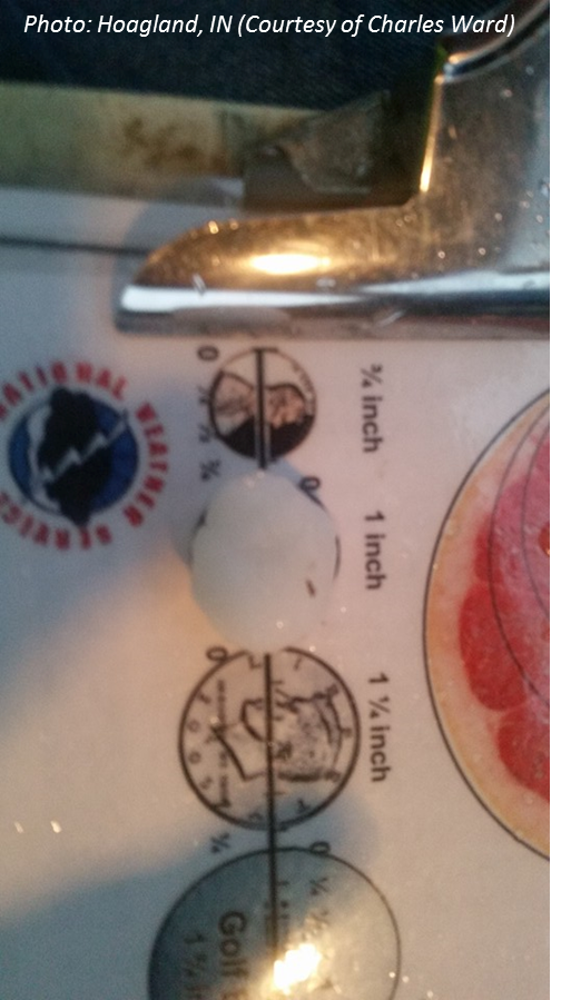
0657 PM HAIL HOAGLAND 40.95N 84.99W
03/27/2016 M1.00 INCH ALLEN IN TRAINED SPOTTER
MULTIPLE REPORTS OF HAIL 0.88 INCH TO 1.0 IN
DIAMETER.
0655 PM HAIL HOAGLAND 40.95N 84.99W
03/27/2016 M0.75 INCH ALLEN IN TRAINED SPOTTER
0.5 INCH TO 0.75 INCH HAIL
0654 PM HAIL 2 SSE WALLEN 41.13N 85.15W
03/27/2016 M0.88 INCH ALLEN IN PUBLIC
0650 PM HAIL 2 ESE WALLEN 41.15N 85.14W
03/27/2016 M1.50 INCH ALLEN IN TRAINED SPOTTER
MULTIPLE REPORTS OF QUARTER TO PING PONG
SIZED HAIL.
0645 PM HAIL 2 SE WALLEN 41.14N 85.14W
03/27/2016 M1.00 INCH ALLEN IN TRAINED SPOTTER
MULTIPLE REPORTS OF DIME-QUARTER SIZED HAIL.
0643 PM HAIL 2 SW TOCSIN 40.80N 85.14W
03/27/2016 M1.00 INCH WELLS IN TRAINED SPOTTER
0640 PM HAIL KINGSLAND 40.83N 85.17W
03/27/2016 M1.25 INCH WELLS IN TRAINED SPOTTER
0638 PM HAIL 1 SSE KINGSLAND 40.82N 85.17W
03/27/2016 M1.25 INCH WELLS IN PUBLIC
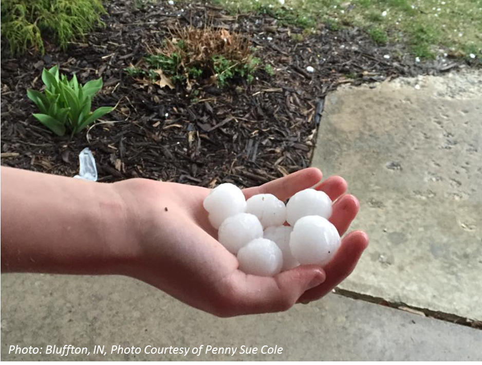
0635 PM HAIL 1 NW BLUFFTON 40.75N 85.18W
03/27/2016 M1.75 INCH WELLS IN TRAINED SPOTTER
0629 PM HAIL 3 NE MARKLE 40.86N 85.30W
03/27/2016 E0.50 INCH WELLS IN PUBLIC
HAIL UP TO 0.5 INCH IN DIAMETER OR LESS.
0625 PM HAIL 1 SSE NINE MILE 40.96N 85.22W
03/27/2016 E0.75 INCH ALLEN IN TRAINED SPOTTER
MOSTLY SMALLER THAN PENNY SIZED BUT THE
LARGEST WAS ABOUT PENNY SIZED.
0625 PM HAIL 1 NNE PEABODY 41.10N 85.48W
03/27/2016 M0.75 INCH WHITLEY IN TRAINED SPOTTER
PEA SIZED HAIL. GUST TO 45 MPH MEASURED.
0623 PM HAIL MARION 40.55N 85.67W
03/27/2016 M0.50 INCH GRANT IN TRAINED SPOTTER
0620 PM HAIL 2 NE WARREN 40.70N 85.40W
03/27/2016 M1.00 INCH HUNTINGTON IN FIRE DEPT/RESCUE
0619 PM HAIL 1 E MARION 40.55N 85.65W
03/27/2016 M0.88 INCH GRANT IN TRAINED SPOTTER
HAIL FROM PEA TO NICKLE SIZED REPORTED.
RECEIVED MULTIPLE REPORTS.
0615 PM HAIL 2 N MAJENICA 40.79N 85.46W
03/27/2016 U1.50 INCH HUNTINGTON IN TRAINED SPOTTER
SIDING DAMAGE, SCREEN DAMAGE AND A BROKEN
WINDOW DUE TO HAIL.
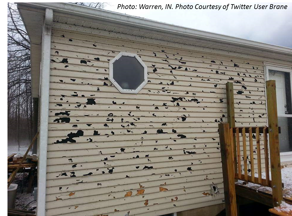
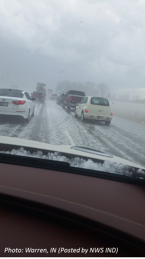
0613 PM HAIL WARREN 40.68N 85.43W
03/27/2016 M1.50 INCH HUNTINGTON IN EMERGENCY MNGR
PHOTOS SENT IN FROM WARREN OF PING PONG
SIZED HAIL.
0613 PM HAIL 1 WSW WARREN 40.68N 85.44W
03/27/2016 E1.50 INCH HUNTINGTON IN EMERGENCY MNGR
SIDING AND SCREEN DAMAGE FROM HAIL AT
SEVERAL HOUSES ALONG CR 1000 S WEST OF SR 5.
0609 PM HAIL VAN BUREN 40.62N 85.51W
03/27/2016 M0.25 INCH GRANT IN TRAINED SPOTTER
PEA SIZED HAIL REPORTED
0608 PM HAIL 1 N GAS CITY 40.50N 85.61W
03/27/2016 M0.75 INCH GRANT IN TRAINED SPOTTER
PENNY/DIME SIZED HAIL.
0549 PM HAIL 1 NE MARION 40.56N 85.66W
03/27/2016 M0.75 INCH GRANT IN TRAINED SPOTTER
RECEIVED SEVERAL REPORTS OF PEA TO PENNY
SIZED HAIL. HEAVY RAIN ALSO REPORTED.
A low pressure system developed over northeast Illinois/northwest Indiana Sunday afternoon, strengthening as it moved eastward into Ohio through the evening. This system brought just the right conditions for severe weather to develop, mainly east of a line from Logansport, IN to Three Rivers, MI.
| Surface Analysis/Radar Loop from 10 am Sunday 3/27/16 through 8 pm Sunday Night |
 |
| This loop shows the surface low pressure tracking eastward into northern Indiana and northwest Ohio Sunday into Sunday night, coupled with radar images from the event. |
Ingredients for severe weather came together perfectly. We had decent instability (CAPE, red lines), wind shear (35-40 knots Bulk Effective Shear), moisture and lift (frontal boundary seen in image above). The CIN (Blue shading, blue dashed lines), or inhibition, is what we call a "CAP." This prevents storms from developing. Eventually we broked the CAP, which is when storms starting developing in central Indiana.
| Regional Radar Loop and CAPE, Bulk Effective Shear, and CIN from Sunday afternoon into Sunday Night (3/27/16). |
 |
| A regional view of the radar evolution with overlayed CAPE (measure of Instability), CIN (the cap-or inhibition), and Bulk Effective Shear (wind shear makes the storms rotate). |
The primary threat with the thunderstorms was large hail. Hail as large as golf ball-sized was reported near Bluffton in Wells county. Several reports of large hail between quarter-sized and ping pong ball-sized were also received. The following radar image is from 606 pm EDT for a storm in Huntington county near Warren, IN. This storm produced ping ball sized hail in Warren, IN at 613 pm EDT. In the image below, radar depicted what is called a Three Body Scatter Spike (TBSS) in the reflectivity data. This signature is a common one on radar for storms producing large hail. In this image, the radar is located north-northeast of this storm. Note the weak reflectivities (the light blues) extending along a radial away from the storm in Warren, IN. As the radar beam encounters the large hail in the storm, part of the energy on the radar beam is reflected back to the radar, but part of the energy is reflected to the surface, before being reflected back upward where it is scattered again by the large hail. The actual TBSS is not depicting the actual hail or rain in the storm, but is an artifact of these multiple reflections of the beam by the large hail.

One of the many ways the new dual pol radar technology helps with is identifying hail. Correlation Coefficient is depicted below for the same storm as above, at the same time. Correlation Coefficient is a measure of how similar the horizontal pulses and vertical pulses sent out by the radar are behaving from pulse to pulse. Lower values indicate particles sampled are different shapes/sizes like hail or debris. Higher values indicate more similar shape amongst the precipitation particles (rain with similar drop sizes, dry/small snow). The TBSS shows up as dark blue, tipping us off to hail. Additionally, where the precipitation core is, you can see yellow values indicating varying drop sizes and large hail. A great reference to dual pol data can be found in the "Other Useful Links" section below.

Data used above is depicted using GR2 Analyst.
 |
 |
 |
 |
 |
 |
Spotter Training Videos Online: How Thunderstorms Develop, Thunderstorm Ingredients, Thunderstorm Types, etc.

