Overview
|
Strong to severe thunderstorms moved across northern Indiana, southern Michigan and northwest Ohio during the afternoon and evening on March 30th, 2025. Storm surveys were conducted in multiple locations across northern Indiana and far southern Lower Michigan on March 31st and April 1st. Surveys were paused as the area prepared for and was impacted by yet another round of severe storms on April 2nd. As a result of the extensive amount of the damage between the 2 events, confirmation of some damage was delayed until April 11th. Last Update: 4/11/25 7 PM EDT.
Thank you to our partners, the media, weather spotters, and the public for sending us pictures, videos, and reports of damage. We appreciate you!
|
Tornadoes
Select a tornado from the table to zoom into the track and view more information. The default table view is limited to 8 tracks, but can be scrolled by a mouse wheel or dynamically expanded. Additionally, the table can fill the entire window by clicking the small circular expanding arrow icon at the very top right of the table and returned to its original size by clicking the button again. The side information panel that opens over the map can be closed using the "X" on the upper right corner of the pop-up. Zoom into the map and click damage points to see detailed information and pictures from the surveys.
|
NOTE: times shown below are local to your device's time zone. |

The Enhanced Fujita (EF) Scale classifies tornadoes into the following categories:
| EF0 Weak 65-85 mph |
EF1 Moderate 86-110 mph |
EF2 Significant 111-135 mph |
EF3 Severe 136-165 mph |
EF4 Extreme 166-200 mph |
EF5 Catastrophic 200+ mph |
 |
|||||
| Tornadoes that fail to impact any ratable structures on the EF-Scale are rated EF-Unknown (EF-U) | |||||
Wind & Hail
Wind
Straight Line Wind Damage Surveys
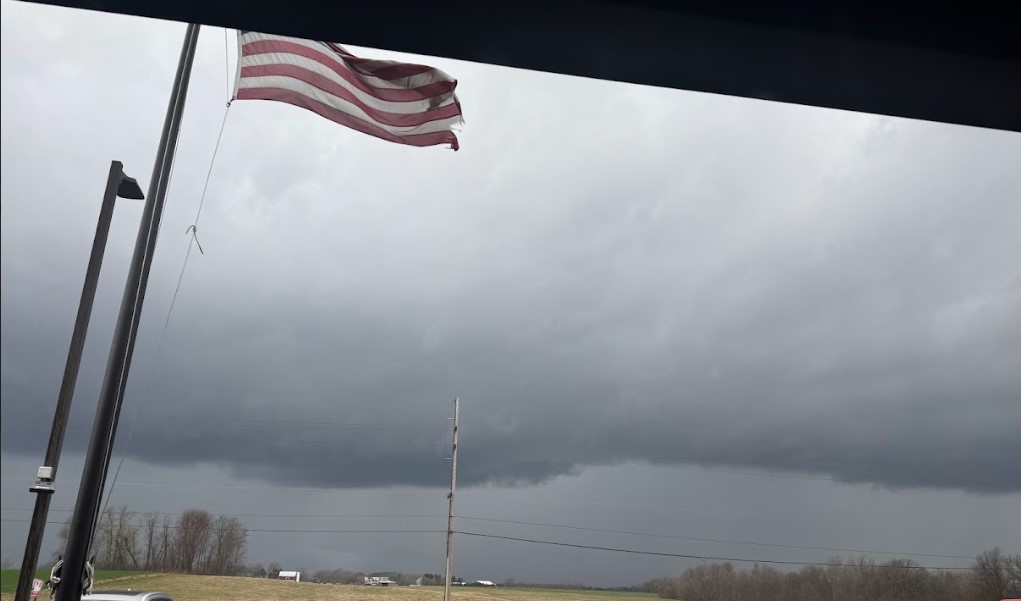
NWS Northern Indiana surveyed several areas of Straight-Line Wind damage [Microbursts]. Summaries of those surveys are provided below. A list of the highest measured wind gusts and hail reports from March 30th, 2025 is below the photos.
NWS and EMA officials completed a survey of damage in the Kingsford Heights and Fish Lake areas of LaPorte county. The damage was largely comprised of tree damage, but there was also a few power poles down, some roof damage to a home, and a toppled center pivot. Surveyed damage was consistent with straight lined winds reaching an estimated 70 to 80 mph winds.
| Photos Coming Soon! | Photos Coming Soon! | Photos Coming Soon! | Photos Coming Soon! |
Highest Measured Wind Gusts March 30th, 2025
Public Information Statement
National Weather Service Northern Indiana
1211 AM EDT Mon Mar 31 2025

Location                     Speed     Time/Date       Lat/Lon

...Indiana...

...Allen County...
2 SSW Leo-Cedarville         66 MPH    0536 PM 03/30   41.19N/85.03W
FORT WAYNE                   40 MPH    0527 PM 03/30   41.03N/85.17W

...Cass County...
Walton                       43 MPH    0430 PM 03/30   40.66N/86.22W
Galveston                    43 MPH    0430 PM 03/30   40.56N/86.19W

...De Kalb County...
Auburn Dekalb C              52 MPH    0535 PM 03/30   41.30N/85.07W

...Elkhart County...
Elkhart Municipa             64 MPH    0454 PM 03/30   41.72N/86.00W
Goshen                       55 MPH    0458 PM 03/30   41.53N/85.78W

...Grant County...
Grant County Municipal Apt   45 MPH    0515 PM 03/30   40.48N/85.68W

...Huntington County...
Huntington                   48 MPH    0515 PM 03/30   40.85N/85.45W
Huntington                   45 MPH    0518 PM 03/30   40.83N/85.53W

...Kosciusko County...
Warsaw Muni                  49 MPH    0455 PM 03/30   41.27N/85.83W

...La Porte County...
La Porte                     52 MPH    0516 PM 03/30   41.57N/86.73W

...Marshall County...
Plymouth Site KC65           53 MPH    0435 PM 03/30   41.37N/86.30W
Asel                         45 MPH    0425 PM 03/30   41.31N/86.43W

...Miami County...
Grissom AFB Peru             64 MPH    0432 PM 03/30   40.63N/86.15W
Peru                         59 MPH    0442 PM 03/30   40.76N/86.07W
Amboy                        52 MPH    0446 PM 03/30   40.59N/85.98W

...Noble County...
2 ENE Cromwell               57 MPH    0505 PM 03/30   41.42N/85.58W

...St. Joseph County...
South Bend International Ap  61 MPH    0444 PM 03/30   41.70N/86.32W
1 ENE Gulivoire Park         59 MPH    0442 PM 03/30   41.62N/86.22W

...Whitley County...
Northeast Purdue Agricultura 53 MPH    0510 PM 03/30   41.11N/85.40W

...Michigan...

...Berrien County...
Benton Harbor                78 MPH    0454 PM 03/30   42.13N/86.42W
2.0 W Spinks Corners (MAWN)  57 MPH    0500 PM 03/30   42.08N/86.36W
I94mm0419                    49 MPH    0510 PM 03/30   42.18N/86.24W
Saint Joseph                 48 MPH    0450 PM 03/30   42.13N/86.47W
I94mm0372                    46 MPH    0510 PM 03/30   42.17N/86.33W

...Branch County...
Coldwater                    59 MPH    0540 PM 03/30   41.92N/85.03W
QUINCY                       56 MPH    0555 PM 03/30   41.94N/84.90W

...St. Joseph County...
Sturgis Kirsch               64 MPH    0622 PM 03/30   41.80N/85.43W

...Ohio...

...Allen County...
2 WNW Westminster            54 MPH    0744 PM 03/30   40.71N/84.02W

...Henry County...
DESHLER                      42 MPH    0715 PM 03/30   41.20N/83.89W

...Putnam County...
Ottawa                       43 MPH    0721 PM 03/30   41.03N/83.98W
Hail
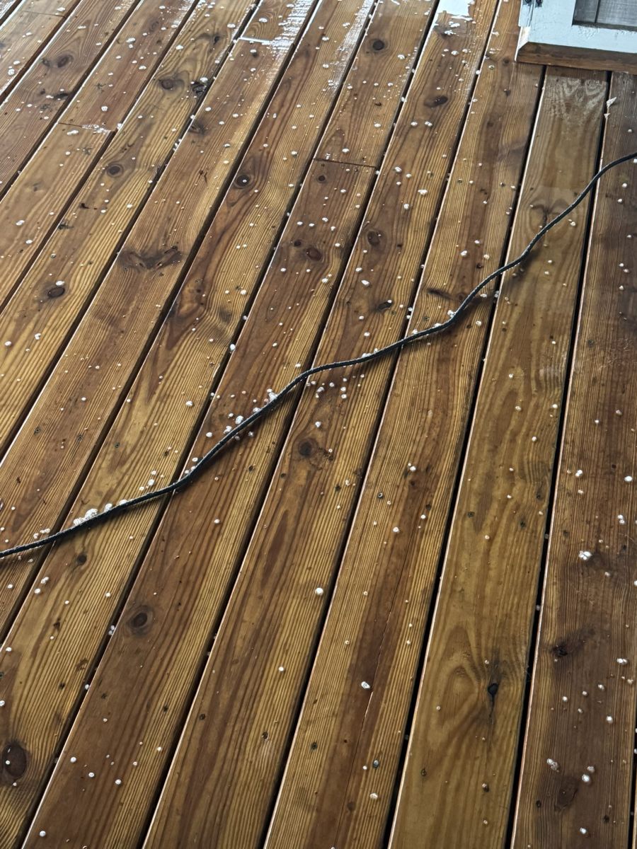 |
| Hail in Pierceton, IN March 30th, 2025 from @Stone_R |
Hail Reports from March 30th, 2025
Public Information Statement
National Weather Service Northern Indiana
1219 AM EDT Mon Mar 31 2025

Location                     Size      Time/Date       Lat/Lon

...Indiana...

...Allen County...
Huntertown                   0.50 in   0527 PM 03/30   41.23N/85.17W

...Elkhart County...
Waterford Mills              0.75 in   0502 PM 03/30   41.54N/85.82W
Goshen                       0.70 in   0458 PM 03/30   41.58N/85.84W
1 E Waterford Mills          0.25 in   0455 PM 03/30   41.54N/85.82W

...Kosciusko County...
1 SSE James Lake             0.50 in   0501 PM 03/30   41.31N/85.72W

...Lagrange County...
2 WNW Howe                   1.00 in   0510 PM 03/30   41.73N/85.46W

...Wabash County...
1 NE North Manchester        0.70 in   0450 PM 03/30   41.01N/85.77W

...Ohio...

...Defiance County...
2 SSW Farmer                 0.75 in   0558 PM 03/30   41.36N/84.65W

...Williams County...
Bryan                        0.50 in   0606 PM 03/30   41.47N/84.55W
Storm Reports
Due to the April 2nd event, the summary below does not contain every report received by our office. Click here For the most up to date list of Preliminary Reports. Preliminary Local Storm Report...Summary National Weather Service Northern Indiana 534 PM EDT Mon Mar 31 2025 ..TIME... ...EVENT... ...CITY LOCATION... ...LAT.LON... ..DATE... ....MAG.... ..COUNTY LOCATION..ST.. ...SOURCE.... ..REMARKS.. 0400 PM Tstm Wnd Dmg 1 N Indiana Beach 40.80N 86.77W 03/30/2025 White IN Public Large tree snape in half 10 feet up. Also 3 12 foot diameter trees snapped at base. 0407 PM Tstm Wnd Dmg 1 NNE Westville 41.56N 86.90W 03/30/2025 La Porte IN Emergency Mngr Lines down across Highway 421. 0410 PM Tstm Wnd Dmg South Wanatah 41.41N 86.89W 03/30/2025 La Porte IN Emergency Mngr Power lines down across 421. 0411 PM Tstm Wnd Dmg 1 WNW North Judson 41.22N 86.79W 03/30/2025 Starke IN Public Large sections of roofing material blown off St Peter Lutheran Church. 0414 PM Tstm Wnd Dmg Logansport 40.75N 86.36W 03/30/2025 Cass IN Emergency Mngr Structural damage to a barn at 2450 E 475 S. Roof and siding blown off and strewn across road/field. Large limbs also downed. Time estimated based on radar. 0414 PM Tstm Wnd Dmg Clymers 40.71N 86.45W 03/30/2025 Cass IN Emergency Mngr Downed power lines. 0414 PM Tstm Wnd Dmg 3 NW Dunkirk 40.80N 86.43W 03/30/2025 Cass IN Emergency Mngr Multiple trees down on US 35. 0414 PM Tstm Wnd Dmg 1 NE Dunkirk 40.76N 86.38W 03/30/2025 Cass IN Emergency Mngr Trees downed on Holland Street and Water St. 0414 PM Tstm Wnd Dmg 1 WSW Georgetown 40.73N 86.52W 03/30/2025 Cass IN Emergency Mngr Tree into a house on Ridgeview Way. No information on the tree size/health. 0415 PM Tstm Wnd Dmg 1 E Lake Cicott 40.77N 86.50W 03/30/2025 Cass IN Emergency Mngr Trees down on US 24 near Georgetown. 0415 PM Tstm Wnd Dmg 1 NW Leases Corner 40.88N 86.38W 03/30/2025 Cass IN Emergency Mngr There are numerous reports of tree damage and several reports of structural damage around Cass County, IN. Structural damage includes fencing downed and siding blown off, there was damage to a barn where roof was blown off, and more. Locations included IN 35 near Michael Lane, 825N and 900 N, N 525W and IN 16, 400 N and IN 35, 800W and 50S near Lake Cicott]. At 650 W and 800N a shed blew over and the gas pipeline was damaged and leaking. Reports were between 4 pm and 4:25 pm ET across the county per Radar. 0415 PM Tstm Wnd Dmg Waterford 41.67N 86.84W 03/30/2025 La Porte IN Trained Spotter Tree downed across the road, large limbs downed. 0415 PM Tstm Wnd Dmg Trail Creek 41.70N 86.86W 03/30/2025 La Porte IN Trained Spotter Several big tree branches are down and this one fell on a house on Avondale Ave in Trail Creek. 0415 PM Tstm Wnd Dmg Trail Creek 41.69N 86.85W 03/30/2025 La Porte IN Amateur Radio 400 Block of Laurel Drive has trees on top of houses (houses still habitable). Numerous reports of trees and powerlines down in this area and around Michigan City. Time estimated by radar. 0417 PM Tstm Wnd Dmg La Porte 41.61N 86.72W 03/30/2025 La Porte IN Emergency Mngr Several trees reported down in La Porte. 0419 PM Tstm Wnd Dmg 1 SSE Tracy 41.48N 86.68W 03/30/2025 La Porte IN Trained Spotter Numerous reports of damage, including trees downed and roof blow off. Metal siding is hanging from power lines in one video, damage to silo. Power is out. 0420 PM Tstm Wnd Dmg 1 W Michigan City 41.71N 86.90W 03/30/2025 La Porte IN Emergency Mngr Trees downed in Michigan City with estimated wind gust of 60 mph. There are power outages. A large branch was reported downed on Maple Street. 0420 PM Tstm Wnd Dmg 2 WNW Michigan City 41.73N 86.91W 03/30/2025 LMZ046 IN Emergency Mngr Trees downed in Michigan City with estimated wind gust of 60 mph. There are power outages. A large branch was reported downed on Maple Street. 0422 PM Tstm Wnd Dmg 1 NW Stillwell 41.57N 86.61W 03/30/2025 La Porte IN Amateur Radio Barn roof blew off and was temporarily blocking road at E State Rd 4 and SR 104. Time estimated by Radar. 0425 PM Tstm Wnd Dmg Rochester 41.06N 86.20W 03/30/2025 Fulton IN Emergency Mngr Numerous reports of trees and powerlines down across the county (location varies). Per radar the time of most reports in county were likely between 4:00 pm and 4:40 pm EDT. 0425 PM Tstm Wnd Dmg Fish Lake 41.57N 86.55W 03/30/2025 La Porte IN Emergency Mngr Numerous trees and powerlines downed across the area of Fish Lake. Debris on the roads, some trees in houses. There are several large uprooted trees. There are several trees snapped at the mid section/top, and one powerline that was snapped and broken near a house. 0427 PM Tstm Wnd Dmg 1 NW Culver 41.23N 86.43W 03/30/2025 Marshall IN Public Two poles down and in road near intersection of SR 10 and SR 17. 0428 PM Tstm Wnd Dmg 2 SW Tiosa 41.14N 86.24W 03/30/2025 Fulton IN Trained Spotter Trees down and a 58 mph gust was also measured in an anemometer. Time estimated by radar. 0429 PM Tstm Wnd Dmg 1 SE Donaldson 41.35N 86.43W 03/30/2025 Marshall IN Emergency Mngr *** 1 INJ *** Mobile home demolished. Location approximate. 0429 PM Tstm Wnd Dmg 1 NNW Rochester 41.08N 86.21W 03/30/2025 Fulton IN Public Large portion of a metal outbuilding roof and wall toppled into the street. 0429 PM Tstm Wnd Dmg Rochester 41.06N 86.19W 03/30/2025 Fulton IN Public 5 foot radio tower blown down at Fulton Co. Indiana EMA building about 10 minutes ago due to high winds. Location just east of the junction of State Rd 25 and State Rd 14 on east Rochester Indiana. 0430 PM Tstm Wnd Dmg 2 SSW Mexico 40.78N 86.13W 03/30/2025 Miami IN Public Semi blown over on US 31 north of Peru, IN. Specific location not known. Unknown if driver was injured. 0430 PM Tstm Wnd Dmg 1 N Roseland 41.73N 86.25W 03/30/2025 St. Joseph IN Public Trees down over the road. 0430 PM Tstm Wnd Dmg Plymouth 41.35N 86.31W 03/30/2025 Marshall IN Emergency Mngr Numerous reports of tree damage around the county. Tree was reported downed on a home in Plymouth at Pretty View Condos. Time for Marshall County Damage was likely between 4:15-4:45 pm EDT per radar. 0430 PM Tstm Wnd Dmg 4 NE Woodland 41.61N 86.15W 03/30/2025 St. Joseph IN Public 25 foot tall tree downed across a driveway. There was also a stacked stone wall failure. Time estimated by radar. 0431 PM Tstm Wnd Dmg 2 NNW Twin Lakes 41.33N 86.38W 03/30/2025 Marshall IN Emergency Mngr Large tree limbs of varying health down, some onto roadway and at least one onto the home. 0432 PM Tstm Wnd Gst 2 S Grissom Afb 40.63N 86.15W 03/30/2025 M64 MPH Miami IN AWOS Corrects previous non-tstm wnd gst report from 2 S Grissom Afb. AWOS station KGUS Grissom AFB Peru. 0435 PM Tstm Wnd Dmg 2 SW Etna Green 41.25N 86.07W 03/30/2025 Marshall IN Trained Spotter Spotter reported major tree damage and some structural damage on S. Beech Rd between SR-10 and 14B road. Siding is in the trees and on the road. There is a narrow path of downed trees through a patch of forest. Time estimated by radar. 0436 PM Tstm Wnd Dmg 2 SW Roseland 41.70N 86.27W 03/30/2025 St. Joseph IN Public Power pole snapped. 0437 PM Tstm Wnd Dmg New Troy 41.88N 86.55W 03/30/2025 Berrien MI Emergency Mngr Several large trees down in and around New Troy. Power is out. 0440 PM Tstm Wnd Dmg 3 NNE Lakeville 41.56N 86.25W 03/30/2025 St. Joseph IN Trained Spotter Trees down and large branches down near US 31 and New Rd. 0440 PM Tstm Wnd Dmg 4 NE Buchanan 41.87N 86.31W 03/30/2025 Berrien MI Public Large pine tree fell on a garage and crushed it. The garage at the house was moved off its foundation. There were shepherds hooks in the hard bent over. There is siding, shingles, fascia and soffit gone off the house. There is debris strewn about the yard. 0442 PM Tstm Wnd Gst Peru 40.76N 86.07W 03/30/2025 E59 MPH Miami IN Public Reported from Facebook. Small tree limbs down. 0442 PM Tstm Wnd Gst 1 ENE Gulivoire Park 41.62N 86.22W 03/30/2025 M59 MPH St. Joseph IN Public From a private weather station near the St. Joe County fair grounds. 0443 PM Tstm Wnd Dmg Buchanan 41.83N 86.37W 03/30/2025 Berrien MI Emergency Mngr Several large trees down in and around Buchanan. Power is out. 0444 PM Tstm Wnd Gst 3 WNW South Bend 41.70N 86.32W 03/30/2025 M61 MPH St. Joseph IN ASOS Corrects previous non-tstm wnd gst report from 3 WNW South Bend. ASOS station KSBN South Bend International Ap. 0444 PM Tstm Wnd Dmg 2 ESE Clunette 41.31N 85.89W 03/30/2025 Kosciusko IN Public Numerous reports of limbs, trees, and powerlines downed around Kosciusko County. There was a tree down on a vehicle near Epworth forest (no injury reported as of this report), a tree down across the road on 2nd street in Pierceton, and powerlines/trees downed across SR-15 south of short ridge drive. There were several reports of 40 to 50 mph wind gusts, including at NWS IWX near North Webster and in Claypool. Time was between 4:34 pm- 4:58 pm EDT for these reports based on radar. 0444 PM Tstm Wnd Dmg 1 S Mishawaka 41.65N 86.17W 03/30/2025 St. Joseph IN Public Approx 6 in limb down. Clipped a house. Along with a partial fence blown over. Time estimated by radar. 0445 PM Tstm Wnd Dmg Mishawaka 41.67N 86.16W 03/30/2025 St. Joseph IN Broadcast Media Large pine tree uprooted and down onto a small residential structure. 0445 PM Tstm Wnd Dmg 3 NE Georgetown 41.76N 86.19W 03/30/2025 St. Joseph IN Public Multiple large trees down. 0445 PM Tstm Wnd Dmg 4 NE Etna Green 41.33N 86.01W 03/30/2025 Kosciusko IN Public Metal hog barn roof torn off and thrown throughout two fields. 0445 PM Tstm Wnd Dmg 5 NW Wakarusa 41.58N 86.08W 03/30/2025 St. Joseph IN Public Trees down, large limbs and branches down, had smaller hail, lost power. 0446 PM Tstm Wnd Dmg 3 WSW Osceola 41.65N 86.12W 03/30/2025 St. Joseph IN Public Drone footage of 8 power poles snapped or bent at the base on Harrison Rd between Beacon Dr and Cedar Wood Ln. 0447 PM Tstm Wnd Dmg 3 NW Treaty 40.75N 85.83W 03/30/2025 Wabash IN Emergency Mngr Semi trailers blown over at State Road 13 at 500 South. No known injuries. 0448 PM Tstm Wnd Dmg Granger 41.74N 86.14W 03/30/2025 St. Joseph IN Amateur Radio Trees downed with debris in roadway around Granger. One location was Brick and Waylan St, another at Brick and Current St. 0448 PM Tstm Wnd Dmg Mishawaka 41.67N 86.17W 03/30/2025 St. Joseph IN Amateur Radio Numerous tree damage reports from the Mishawaka area. There is roof damage and significant shingle loss from a building at Smith and 8th, there are trees down blocking EB Mishawaka Ave and Liberty rd. 0448 PM Tstm Wnd Dmg 1 W Granger 41.74N 86.16W 03/30/2025 St. Joseph IN Public Numerous reports of trees down and branches down from Mishawka High School to Granger. Some instances of property damage such as shingles blown off of a church. 0450 PM Marine Tstm Wind 16 W Keeler 42.13N 86.47W 03/30/2025 M48 MPH Berrien MI Mesonet Mesonet station DVI11762 Saint Joseph. 0450 PM Tstm Wnd Gst 16 W Keeler 42.13N 86.47W 03/30/2025 M48 MPH Berrien MI Mesonet Mesonet station DVI11762 Saint Joseph. 0450 PM Tstm Wnd Dmg Berrien Springs 41.95N 86.34W 03/30/2025 Berrien MI Public barn roof ripped off. multiple trees uprooted. tree tops broken. 0450 PM Tstm Wnd Dmg Edwardsburg 41.79N 86.08W 03/30/2025 Cass MI Public Tree down on garage and tree down over the road on Elkhart Rd just east of M62. Power lines down at Redfield st and Conrad rd intersection. Agriculture irrigation flipped at field on M62 just northeast of M62/may st intersection. 0450 PM Tstm Wnd Dmg Edwardsburg 41.80N 86.08W 03/30/2025 Cass MI Public Two big oak trees down, trampoline thrown at least 50 feet into 2 houses, and roof damage to some buildings. 0451 PM Tstm Wnd Dmg 1 SSW Edwardsburg 41.78N 86.09W 03/30/2025 Cass MI Trained Spotter Grain bin damaged, possibly completely down in Edwardsburg. Additional information not available. Time estimated by radar. 0451 PM Tstm Wnd Dmg 2 SW Edwardsburg 41.78N 86.11W 03/30/2025 Cass MI Trained Spotter Downed power poles across the road near the intersection of May St. and Conrad Rd. Some of the poles were snapped at the base, and others were snapped about 3 to 4 ft off the ground. Nearby, one of the houses had its windows blown out. Time estimated based on radar. 0451 PM Tstm Wnd Dmg 2 SW Edwardsburg 41.78N 86.11W 03/30/2025 Cass MI Trained Spotter Power poles snapped and laying across the road near the intersection of May Street and Conrad Rd. Some poles were snapped at the base, others about 3-4 feet off the ground. One of the houses near the intersection reported their windows were blown out. Time estimated by radar. 0454 PM Tstm Wnd Gst 1 N Benton Heights 42.13N 86.42W 03/30/2025 M78 MPH Berrien MI ASOS Corrects previous non-tstm wnd gst report from 1 N Benton Heights. ASOS station KBEH Benton Harbor. 0454 PM Tstm Wnd Gst 3 NW Elkhart 41.72N 86.00W 03/30/2025 M64 MPH Elkhart IN AWOS Corrects previous non-tstm wnd gst report from 3 NW Elkhart. AWOS station KEKM Elkhart Municipa. 0454 PM Tstm Wnd Dmg Elkhart 41.69N 85.97W 03/30/2025 Elkhart IN Emergency Mngr There were 30 homes with trees on them around the city of Elkhart. 0454 PM Tstm Wnd Dmg Edwardsburg 41.80N 86.08W 03/30/2025 Cass MI Public Tree down on house. 0454 PM Tstm Wnd Dmg Cassopolis 41.91N 86.01W 03/30/2025 Cass MI Public Roof blown off building. 0455 PM Tstm Wnd Gst 2 NNE Warsaw 41.27N 85.83W 03/30/2025 M49 MPH Kosciusko IN AWOS AWOS station KASW Warsaw Muni. 0455 PM Tstm Wnd Dmg 1 S Elkhart 41.67N 85.96W 03/30/2025 Elkhart IN Trained Spotter Estimated winds up to 70 mph at the corner of Wolf Street and Frances Avenue. Uprooted trees and broken tree branches in the area. 0455 PM Tstm Wnd Dmg 1 E Hastings 41.39N 85.91W 03/30/2025 Kosciusko IN Trained Spotter Multiple Irrigation systems rolled and mangled in fields. Systems were still in one piece but rolled over. 0456 PM Tstm Wnd Dmg 1 SSE Elkhart 41.67N 85.96W 03/30/2025 Elkhart IN Broadcast Media Significant structural damage to a building on Sterling Avenue between Bar and Ren Streets. Reported via WBND. 0456 PM Tstm Wnd Dmg 3 ENE Dunlap 41.66N 85.86W 03/30/2025 Elkhart IN Amateur Radio Various large branches down, one tree uprooted on the SE side of Elkhart. 0456 PM Tstm Wnd Dmg 1 NE North Webster 41.34N 85.68W 03/30/2025 Kosciusko IN Emergency Mngr Tree down on parked vehicle. Lines down near Epworth Forest. 0456 PM Tstm Wnd Dmg 3 NNW Eagle Lake 41.84N 86.04W 03/30/2025 Cass MI Public Picture posted on Facebook of a barn with some roof damage. 0457 PM Tstm Wnd Dmg 1 NNW Tippecanoe Lake 41.34N 85.77W 03/30/2025 Kosciusko IN NWS Employee Large rotten based tree snapped at base at CR 750 N and N CR 300 E. 0457 PM Tstm Wnd Dmg 4 E Goshen 41.58N 85.75W 03/30/2025 Elkhart IN Emergency Mngr Barn blow over into the road near the intersection of CR 33 and CR 34. Time estimated from radar. 0458 PM Tstm Wnd Dmg South Whitley 41.09N 85.63W 03/30/2025 Whitley IN Emergency Mngr Tree down in South Whitley and 1/4 inch hail. 0458 PM Tstm Wnd Dmg Goshen 41.58N 85.84W 03/30/2025 Elkhart IN Trained Spotter Several shingles blown off a roof. 0500 PM Tstm Wnd Dmg 4 E Goshen 41.59N 85.75W 03/30/2025 Elkhart IN Trained Spotter Barn blown over. 0504 PM Tstm Wnd Dmg 2 ENE Goblesville 41.00N 85.47W 03/30/2025 Huntington IN Amateur Radio Truck and trailer overturned. 0504 PM Tstm Wnd Dmg 4 N Millersburg 41.58N 85.69W 03/30/2025 Elkhart IN Emergency Mngr *** 1 FATAL *** Corrects previous tstm wnd dmg report from 4 N Millersburg. There was one confirmed fatality when thunderstorm winds blew over an Amish buggy at the intersection of SR-13 and CR 43. Time estimated by radar. 0504 PM Tstm Wnd Dmg 2 WNW Bear Lake 41.33N 85.55W 03/30/2025 Noble IN Trained Spotter Photo received of tree down and some siding removed from a house. 0504 PM Tstm Wnd Dmg Columbia City 41.16N 85.49W 03/30/2025 Whitley IN Emergency Mngr Numerous reports of trees and power lines down across Whitley County. 0505 PM Tstm Wnd Gst 2 ENE Cromwell 41.42N 85.58W 03/30/2025 M57 MPH Noble IN Public Strong wind gust and power outage. 0509 PM Tstm Wnd Dmg Albion 41.40N 85.41W 03/30/2025 Noble IN Broadcast Media Report relayed from WANE 15. There was siding and roof damage at the Noble County Highway Dept. Time estimated by radar. 0511 PM Tstm Wnd Dmg 2 S Scott 41.70N 85.55W 03/30/2025 Lagrange IN Public Lost the roof on two barns. Winds destroyed an out building, blew fuel tanks a long distance, broke telephone poles in half. 0511 PM Tstm Wnd Dmg 1 W Marcellus 42.03N 85.82W 03/30/2025 Cass MI Public Pictures shared on Twitter of a barn suffering damage at Bradt Rd and W Main St (M-40). Debris through to the northeast. 0511 PM Tstm Wnd Dmg 1 E Albion 41.40N 85.40W 03/30/2025 Noble IN Public *** 1 INJ *** Trailer home removed from its foundation (uninhabitable). The roof is gone in sections or caved in. A person was home at the time and was thrown inside, sustaining minor injuries. Debris from nearby properties is scattered along a similar path to the trailer. Time estimated by radar. 0511 PM Tstm Wnd Dmg North Judson 41.21N 86.77W 03/30/2025 Starke IN Public Several trees down on S. Walnut St. between Garden St. and East Weninger. The alleyway heading west of there has trees damaged as well. Powerlines and Pine tree downed at Saint Cyril and Methodius Church. The First Free Will Baptist Church has structural damage (no details provided). Time estimated by radar. 0513 PM Tstm Wnd Dmg 1 NW Rome City 41.50N 85.37W 03/30/2025 Noble IN Public Several large trees uprooted. Moderate shingle damage. 0515 PM Tstm Wnd Dmg 1 W Howardsville 42.03N 85.74W 03/30/2025 St. Joseph MI Trained Spotter Trained spotter reports numerous trees or limbs down around the areas of US 131 and SR 216. 0519 PM Tstm Wnd Dmg Kendallville 41.45N 85.26W 03/30/2025 Noble IN Public Delayed report. A large limb fell down out of a tree. Time estimated by radar. 0520 PM Tstm Wnd Dmg 1 WSW Three Rivers 41.94N 85.65W 03/30/2025 St. Joseph MI Amateur Radio Photos of numerous, large glass panes blown out of a tire shop. Seme trailer blown over in parking lot. Some roof damage is possible. 0520 PM Tstm Wnd Dmg 2 ENE Three Rivers 41.96N 85.59W 03/30/2025 St. Joseph MI Amateur Radio Corrects previous tstm wnd dmg report from 2 ENE Three Rivers. No power at Three Rivers Airport. Multiple trees down in the area including near Andrews Elementary. 0520 PM Tstm Wnd Dmg Sturgis 41.81N 85.42W 03/30/2025 St. Joseph MI Public Numerous reports of trees and branches down at various locations around Sturgis. 0522 PM Tstm Wnd Gst 1 W Sturgis 41.80N 85.43W 03/30/2025 M64 MPH St. Joseph MI AWOS Corrects previous non-tstm wnd gst report from 1 W Sturgis. AWOS station KIRS Sturgis Kirsch. 0525 PM Tstm Wnd Dmg Burr Oak 41.85N 85.32W 03/30/2025 St. Joseph MI Trained Spotter Huge tree down on powerlines. Via NWSChat. Time estimated by radar. 0525 PM Tstm Wnd Dmg 2 S Corunna 41.40N 85.15W 03/30/2025 De Kalb IN Amateur Radio Power poles and trees down. 0525 PM Tstm Wnd Dmg 2 SSE Orland 41.71N 85.16W 03/30/2025 Steuben IN Public Delayed report of damage to a house as well as damage to 3 sheds and a fence. Time estimated by radar. 0530 PM Tstm Wnd Dmg 2 NE Long Lake 41.60N 85.01W 03/30/2025 Steuben IN Public Large tree uprooted. Shingles off house and In trees. Steel off barn roof. Wood impaled into the ground from another property. 0535 PM Tstm Wnd Dmg 2 SE Saint Johns 41.29N 85.09W 03/30/2025 De Kalb IN Public Damage to billboard near I69. 0535 PM Tstm Wnd Dmg Long Lake 41.59N 85.03W 03/30/2025 Steuben IN Emergency Mngr Tree down onto a house. 0536 PM Tstm Wnd Gst 2 SSW Leo-Cedarville 41.19N 85.03W 03/30/2025 M66 MPH Allen IN Trained Spotter Measured wind gust via handheld anemometer. 0537 PM Lightning 1 SW Angola 41.63N 85.01W 03/30/2025 Steuben IN Amateur Radio Lightning struck a power pole near the Football field. 0537 PM Tstm Wnd Dmg 3 SE Wallen 41.13N 85.13W 03/30/2025 Allen IN Public Large tree uprooted across E Washington Center Rd. 0537 PM Tstm Wnd Dmg Angola 41.64N 85.00W 03/30/2025 Steuben IN Amateur Radio Corrects previous tstm wnd dmg report from Angola. 2 to 3 ft diameter healthy pine tree down. Power poles damaged at Trine University. 0540 PM Tstm Wnd Gst 2 SW Coldwater 41.92N 85.03W 03/30/2025 M59 MPH Branch MI AWOS AWOS station KOEB Coldwater. 0600 PM Tstm Wnd Dmg Hillsdale 41.92N 84.63W 03/30/2025 Hillsdale MI Public Trees and power lines down throughout the county. 0600 PM Tstm Wnd Dmg Osseo 41.88N 84.54W 03/30/2025 Hillsdale MI Public Trees down. 0601 PM Tstm Wnd Dmg Montpelier 41.59N 84.60W 03/30/2025 Williams OH Public Outbuilding lost its roof. Roof was toppled into the adjacent field. 0604 PM Tstm Wnd Dmg 3 NE Osseo 41.91N 84.51W 03/30/2025 Hillsdale MI Public Partial barn collapse. Barn looks old and dilapidated. && $$ MCD
Photos & Video
Photos Coming Soon!
| Caption (source) |
Caption (source) |
Caption (source) |
Caption (source) |
Photos Coming Soon!
| Caption (source) |
Caption (source) |
Caption (source) |
Caption (source) |
Photos Coming Soon!
| Caption (source) |
Caption (source) |
Caption (source) |
Caption (source) |
Radar
 |
|||
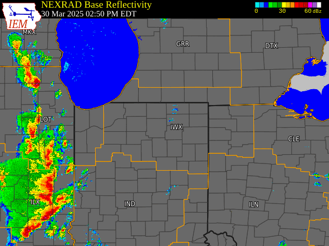
| Radar Loop of the Event (Courtesy IEMCow) |
Caption | Caption | Caption |
Environment
Severe Thunderstorm Ingredients for March 30th, 2025
Thunderstorms need three ingredients to develop: moisture, instability, and lift. The most severe and long-lasting storms [including those that produce tornadoes] require an extra ingredient: strong vertical wind shear. You can read about this in the National Weather Service Spotter Guide. What ingredients were present on March 30th, 2025 for severe storms to develop?
Lift
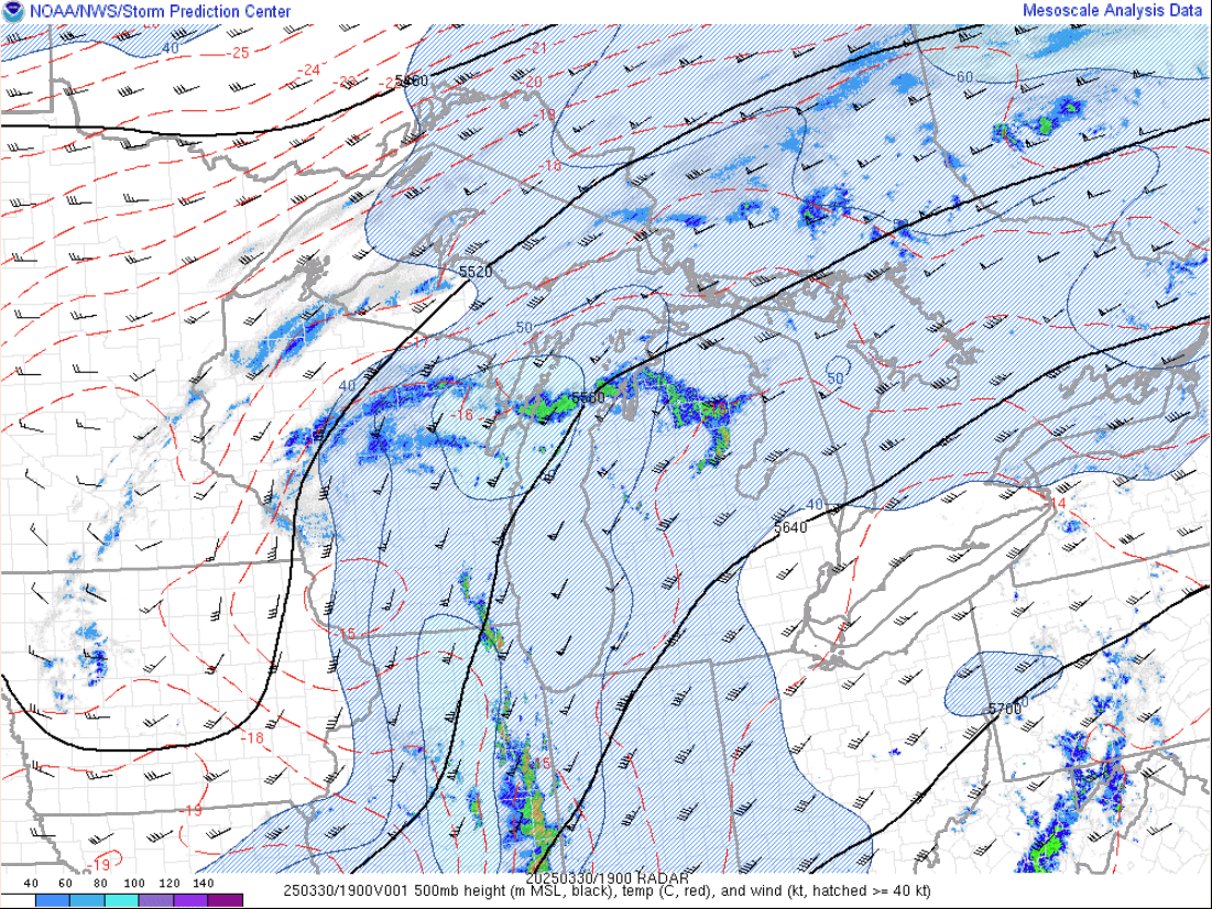
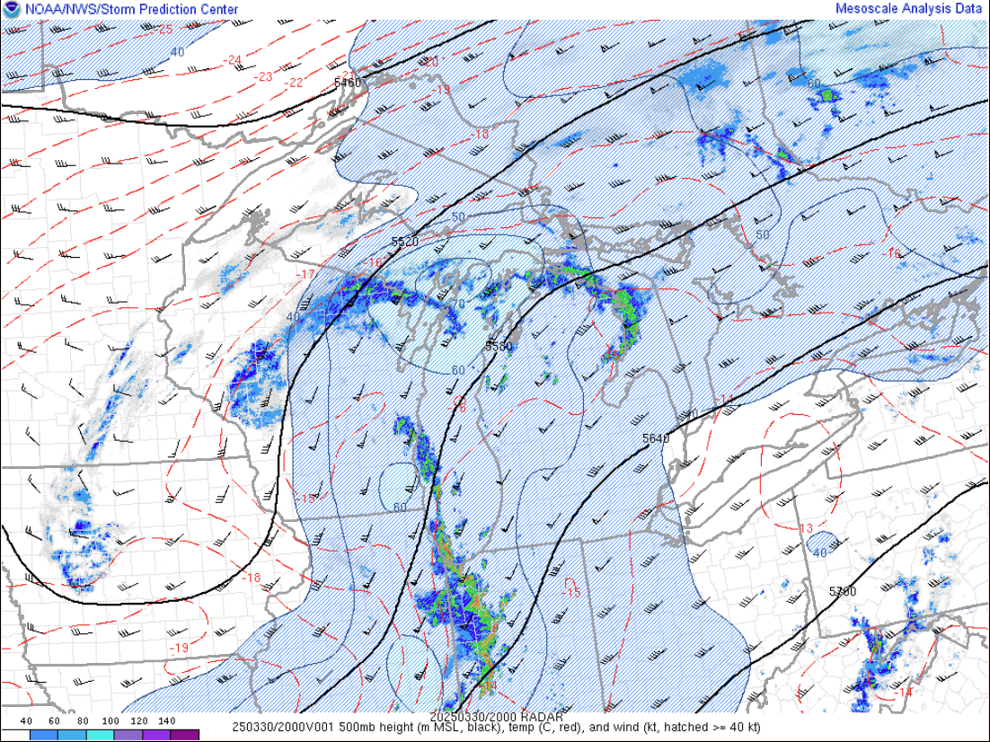
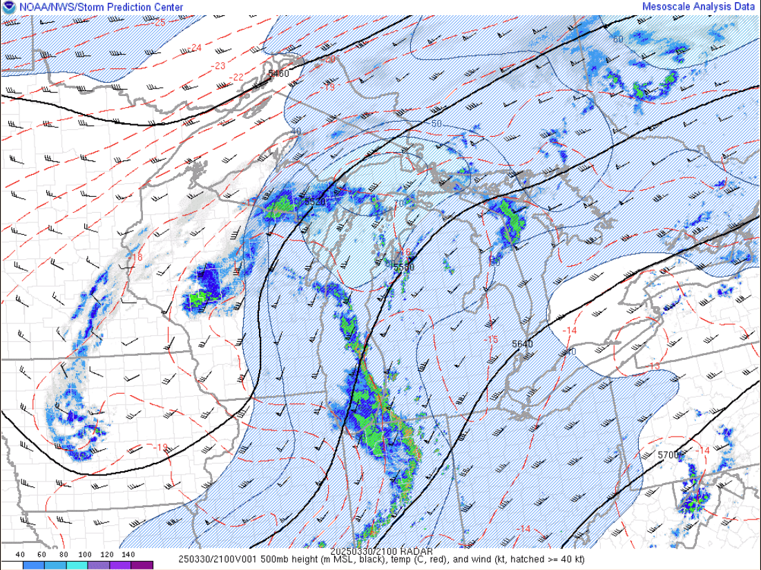
In the mid to upper levels of the atmosphere, a potent trough was providing a source of upward motion for storms. Typically, the best “lift” with an upper level trough is to the right of the base. In the 500mb images below, the base is generally over Iowa. As the trough shifted slightly eastward into the NWS Northern Indiana [IWX] forecast area, storms really began to blossom. This also brought in stronger winds aloft [shown in the blue areas].
 |
 |
 |
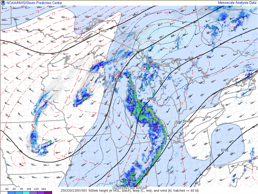 |
| Figure 1: 500mb Trough 2 pm ET SPC Mesoanalysis Archive | Figure 2: 500mb Trough 4 pm ET SPC Mesoanalysis Archive | Figure 3: 500mb Trough 5 pm ET SPC Mesoanalysis Archive | Figure 4: 500mb Trough 7 pm ET SPC Mesoanalysis Archive |
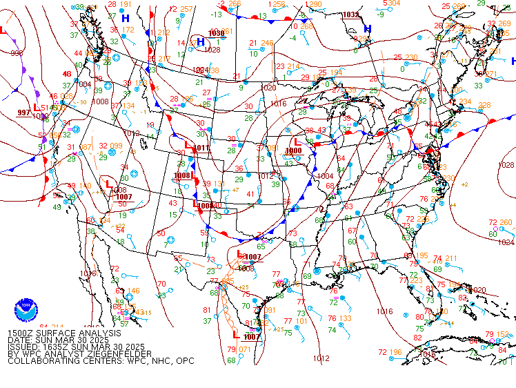
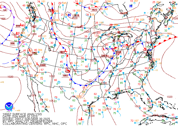
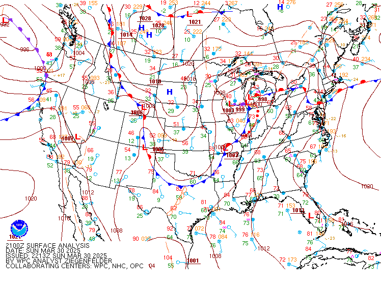
At the surface around 2pm EDT, a low-pressure center over IA/IL was occluding, with the warm front becoming stationary over lower Michigan and the cold front draping southwest into MO/OK/AR. As the cold front moved eastward across the forecast area from around 4 pm to 8 pm EDT, it provided lift for the storms to develop. The red dotted line ahead of the cold front is the symbol for a squall line [line of strong thunderstorms]. These storms eventually outraced the cold front later in the evening.
 |
 |
 |
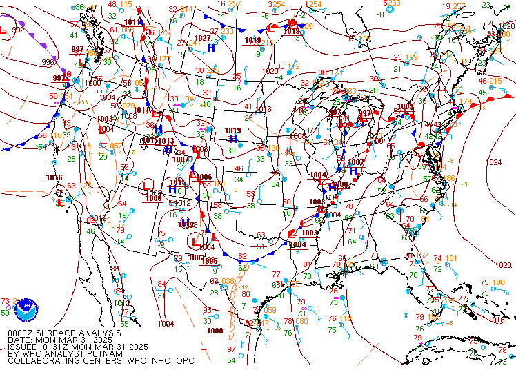 |
| Figure 1: Cold Front at 11 AM ET WPC Surface Analysis Archive | Figure 2: Cold Front at 2 PM ET WPC Surface Analysis Archive | Figure 3: Cold Front at 5 PM ET WPC Surface Analysis Archive | Figure 4: Cold Front at 8 PM ET WPC Surface Analysis Archive |
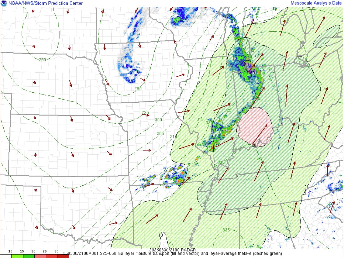
Moisture
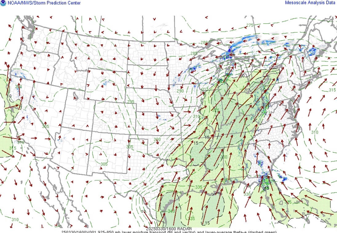
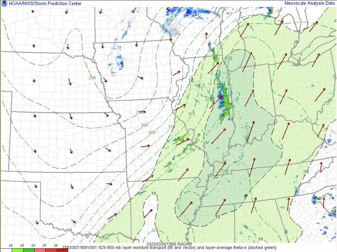
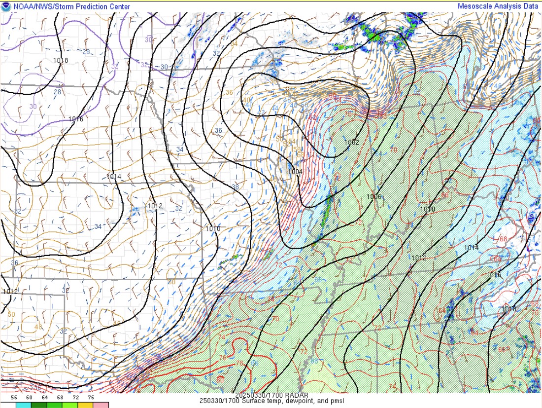
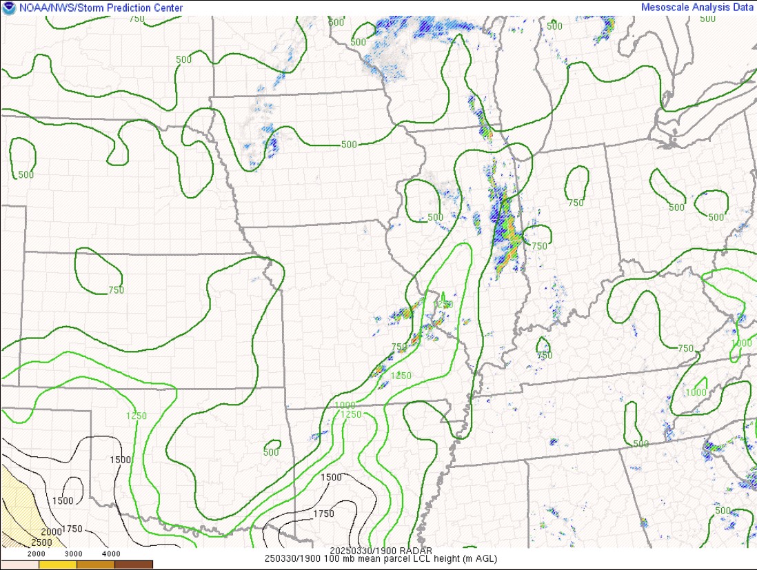
In the lower levels of the atmosphere, a low-level jet [core of stronger winds] was strengthening and transporting in moisture to the area from the Gulf. The red arrows depict moisture transporting north [850mb-925mb], with the greatest moisture transport represented by longer arrows, and best moisture levels are shaded in green or red. Earlier in the day and through the event, a moist (and unstable) airmass was in place along and ahead of the cold front. As the front moved in, the moisture convergence and transport increased [arrows merging into each other] and the storms became a more consolidated line. The first image shows the moist air lifting in from the gulf around noon EDT, and then you can see the increasing values/convergence moving eastward with time. Lower ceiling heights from moist environments[also known as LCLs] are favorable for an increased tornado risk. At the surface, dewpoints were in the 60s and even low 70s ahead of the front [1 pm EDT; Figure 5].
 |
 |
 |
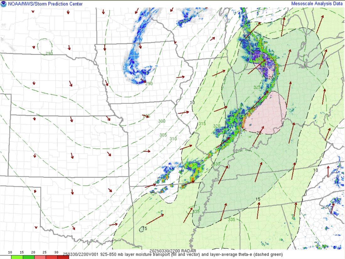 |
| Figure 1: Moisture Transport 12 pm ET SPC Mesoanalysis Archive | Figure 2: Moisture Transport 3 pm ET SPC Mesoanalysis Archive | Figure 3: Moisture Transport 5 pm ET SPC Mesoanalysis Archive | Figure 4: Moisture Transport 6 pm ET SPC Mesoanalysis Archive |
Instability
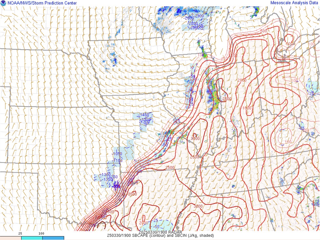
Because the storms moved through during peak heating, we had excellent instability for our area. Instability is measured by surface based CAPE [below], and was around 2000-2500 J/kg around 3 pm EDT ahead of the cold front. As the storms moved eastward through the evening and we began to lose our daytime heating, instability waned to around 1000 J/kg and storms began to weaken.
 |
 |
 |
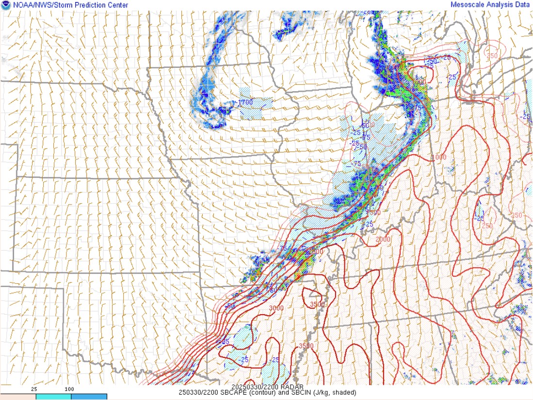 |
| Figure 5: Sfc Dewpt/Pressure 3 pm ET SPC Mesoanalysis Archive | Figure 6: LCL's 3 pm ET SPC Mesoanalysis Archive | Figure 7: 3 pm EDT Sfc CAPE [J/kg] SPC Mesoanalysis Archive | Figure 8: 6 pm EDT Sfc CAPE [J/kg] SPC Mesoanalysis Archive |
Wind Shear
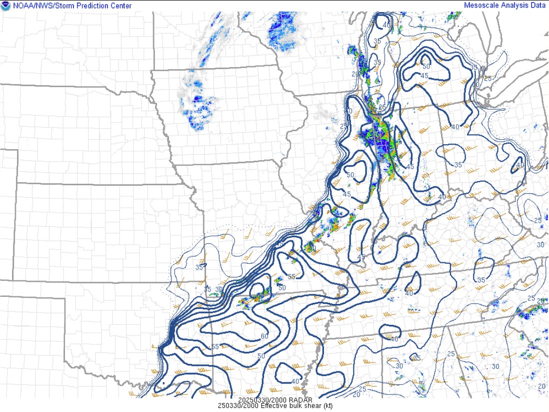
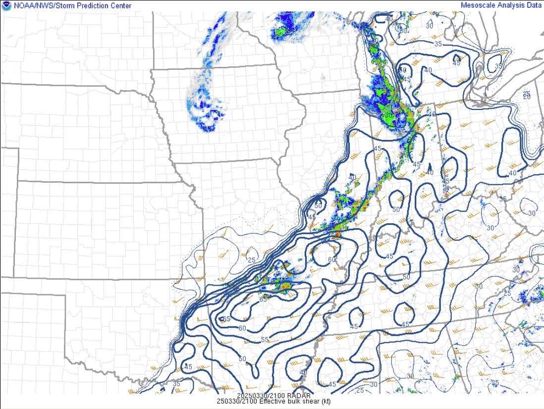
Last but not least, we had around 35 to 50 knots of wind shear [bulk effective shear], which was sufficient to keep storms organized and severe through the afternoon and evening. Shear in the lower levels [0-1 km] was around 20-25 knots, which is supportive of tornadoes.
 |
 |
|
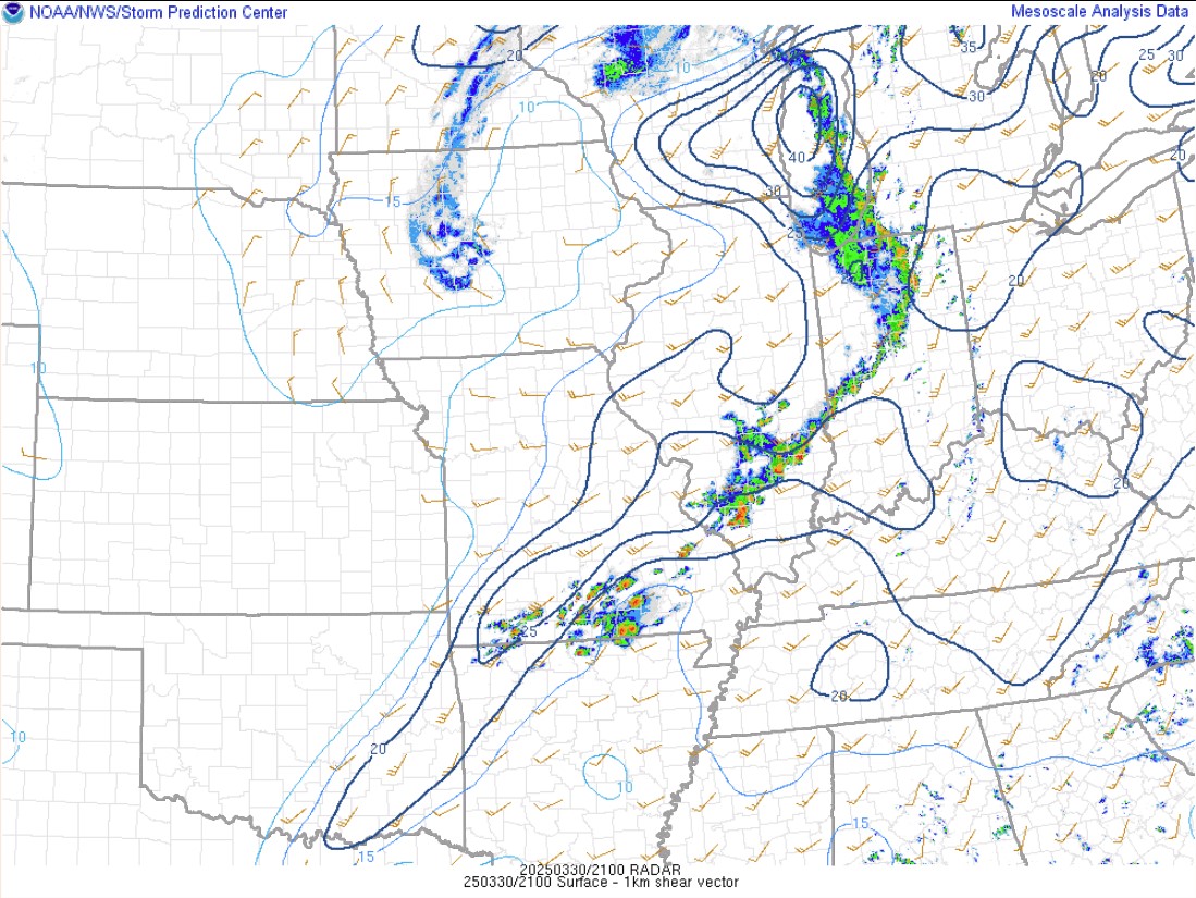 |
| Figure 1: Bulk Effective Shear (kts) 4pm ET SPC Mesoanalysis Archive | Figure 2: Bulk Effective Shear (kts) 5pm ET SPC Mesoanalysis Archive | Figure 3: Bulk Effective Shear (kts) 6pm ET SPC Mesoanalysis Archive | Figure 4: 0-1 km shear (kts) 5pm ET SPC Mesoanalysis Archive |
 |
Media use of NWS Web News Stories is encouraged! Please acknowledge the NWS as the source of any news information accessed from this site. |
|


![NWS Northern Indiana [IWX] forecast area](https://www.weather.gov/images/iwx/misc/cwamapcities.jpg)