Overview
|
A decaying derecho moved through the area late in the evening on July 15th into the early morning hours of the 16th, mainly between 10 PM to 2 AM EDT. Scattered supercells initially developed over eastern Iowa the afternoon of the 15th, which quickly grew into a large linear complex of storms. These storms raced eastward across northern Illinois into southwest Lower Michigan and northern Indiana, prompting several Severe Thunderstorm Warnings for winds up to 70+ mph and Tornado Warnings for embedded rotation along the line. The line was generally strongest west of IN-15 before a gradual weakening trend was observed as the line moved east. Wind gusts of 60 to 70 mph were observed in the aforementioned area before the line became sub-severe as it entered northwest Ohio. Given that the ground was still saturated from recent rain, especially in northwest Indiana, even lesser wind gusts capable of uprooting trees. With damaging wind gusts of 60 to 70+ mph, widespread wind damage was observed. As of July 16th, the Storm Prediction Center has preliminarily classified the July 15-16th severe weather as a derecho across eastern Iowa, northern Illinois, and northern Indiana. The last time a derecho occurred in our area was on June 13th, 2022. Derecho definition: (pronounced deh-REY-cho) A widespread, lone-lived wind storm associated with a rapidly moving line of thunderstorms. A storm is classified as a derecho if the wind damage swath is more than 240 miles in length and has wind gusts of 58 mph of greater along most of the storm's path. Tornadoes can also occur within a derecho.
|
|
Tornadoes:
|
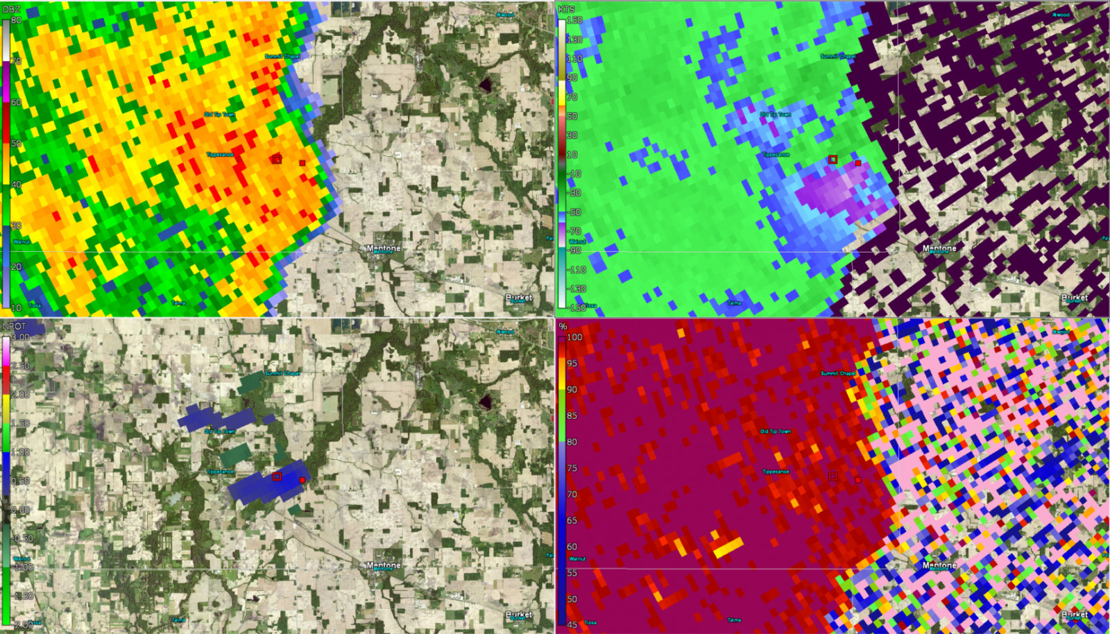
Tornado - SE of Tippecanoe, IN
Track Map 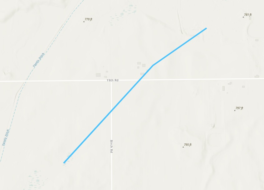 
Downloadable KMZ File |
||||||||||||||||
|
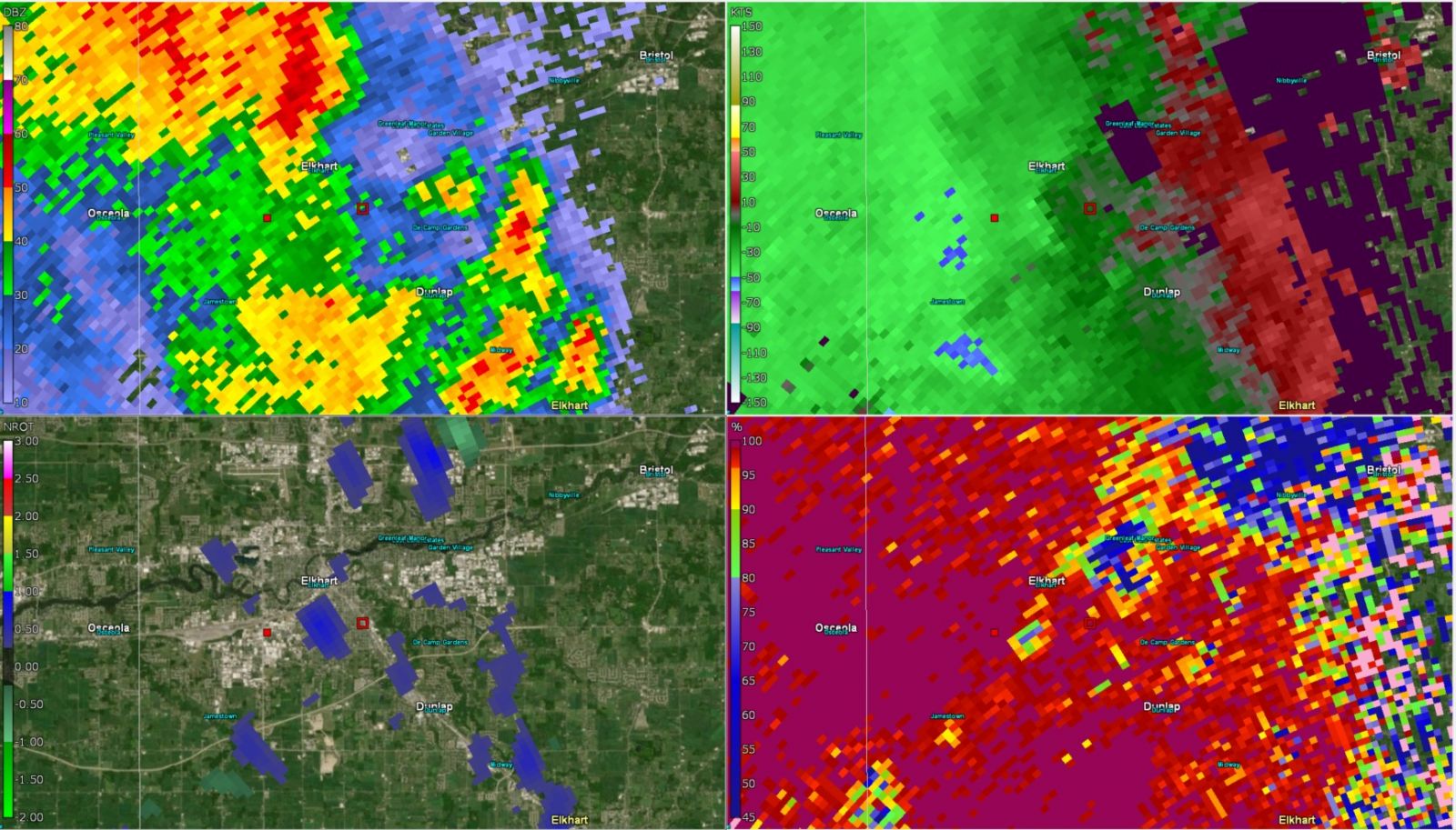
Tornado - Elkhart, IN
Track Map 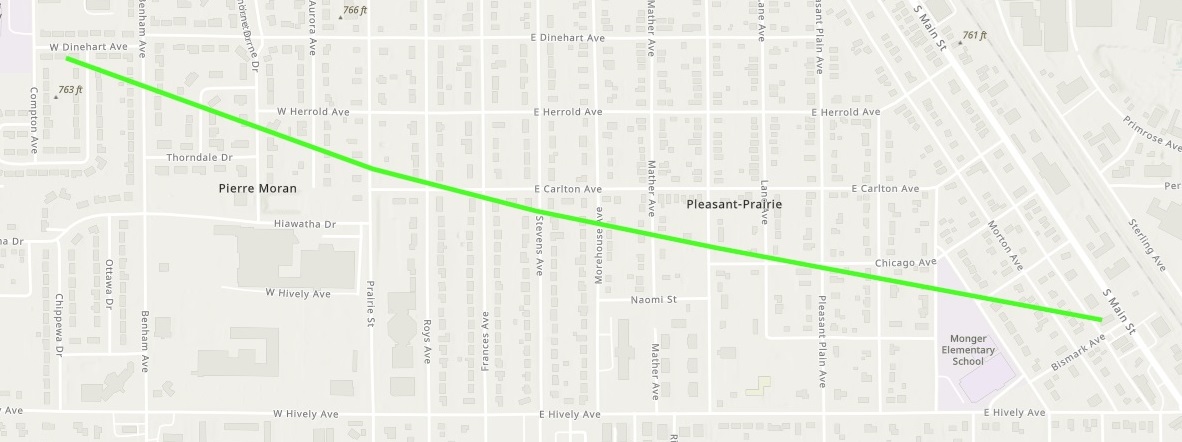
Downloadable KMZ File |
||||||||||||||||
|
Tornado - SSW to SSE of Waterford, IN
Track Map 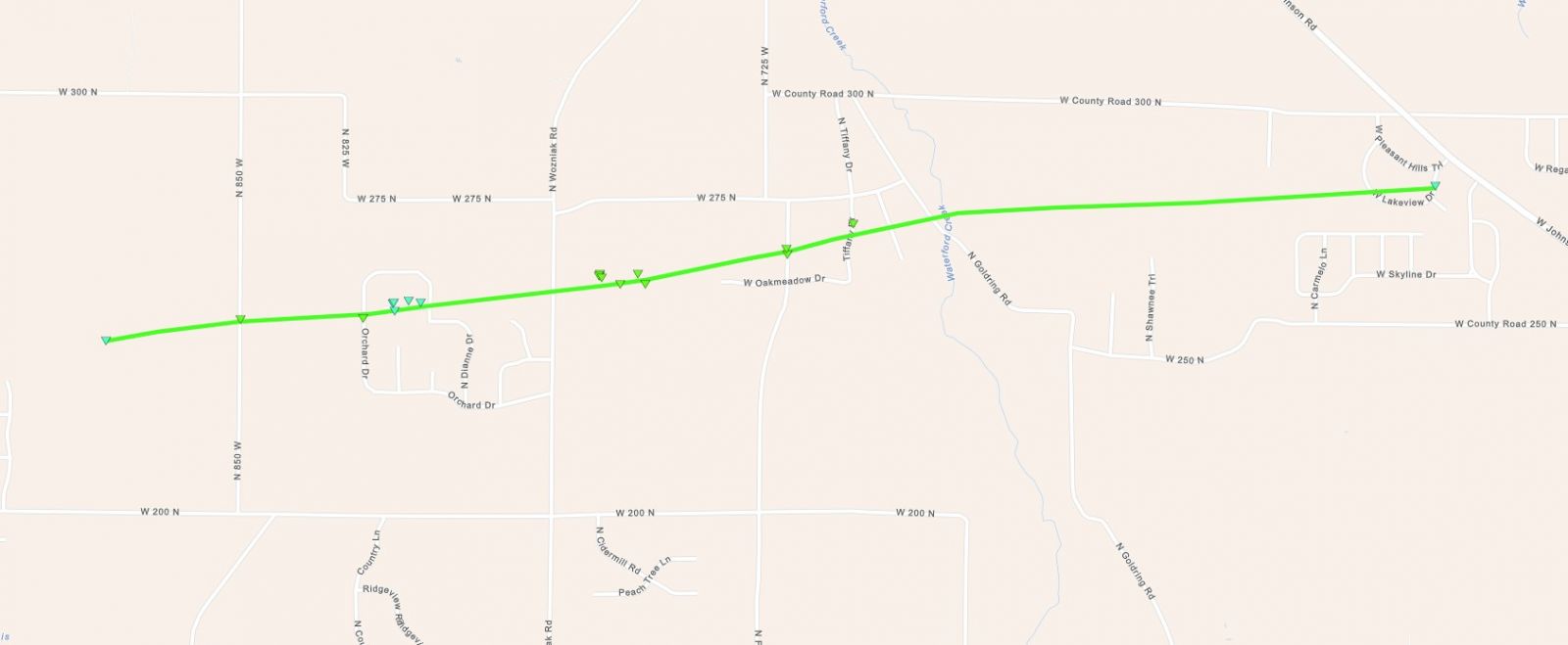
Downloadable KMZ File |
||||||||||||||||
The Enhanced Fujita (EF) Scale classifies tornadoes into the following categories:
| EF0 Weak 65-85 mph |
EF1 Moderate 86-110 mph |
EF2 Significant 111-135 mph |
EF3 Severe 136-165 mph |
EF4 Extreme 166-200 mph |
EF5 Catastrophic 200+ mph |
 |
|||||
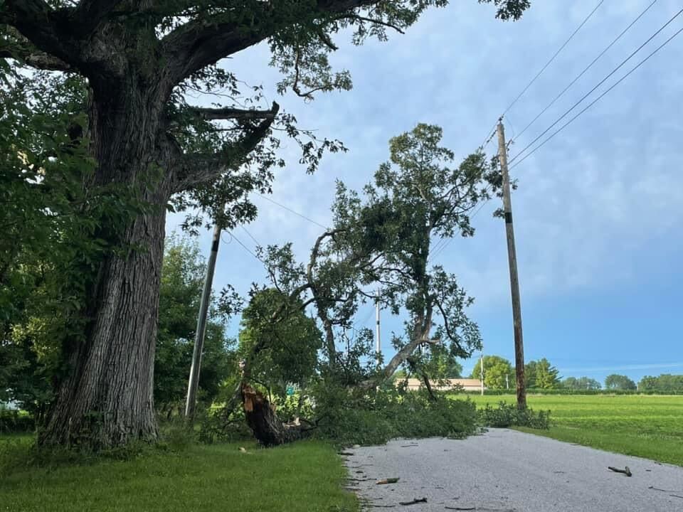
Photos
 |
 |
 |
 |
| The south side of Elkhart sustained damage including many trees and branches being brought down. (Shane Lovely on X) |
A tree came down on a house in the Auburn area of northeast IN. (Brian Gillet /Liz Braden WPTA) |
A barn's roof caved in and a wall of it was knocked down as a result of the strong wind gusts from the storm in Benton, IN of Elkhart county. (Fredrick Ruckersfeldt on X) |
Trees came down around a house in Wakarusa, IN (Christopher Weldy on Facebook) |
 |
 |
 |
 |
| Branches down from the storm in Milford, IN (Danielle Beer on Facebook) |
Tree across the street also brought down power lines in the Wabash area. (Kathy Steele on Facebook) |
Tree branches down in Argos. (Ryan Jackson on Facebook) |
One of the many trees that came down in LaPorte county, IN (Lucas G on X) |
 |
 |
 |
 |
| Trees down in the Cree Lake area north of Kendallville, IN. (Liz Braden/WPTA on X) |
Tree damage near Huntington, IN (Huntington County EMA) |
Extensive tree damage Elkhart County. (NWS storm survey) |
Tree down onto a home in Elkhart. (NWS Storm Survey) |
 |
 |
 |
 |
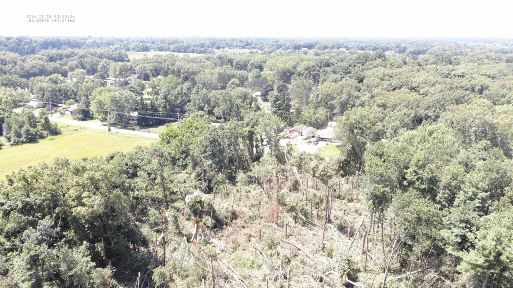
| Drone view of extensive tree fall (LaPorte County EMA) |
Drone view of extensive tree fall (LaPorte County EMA) |
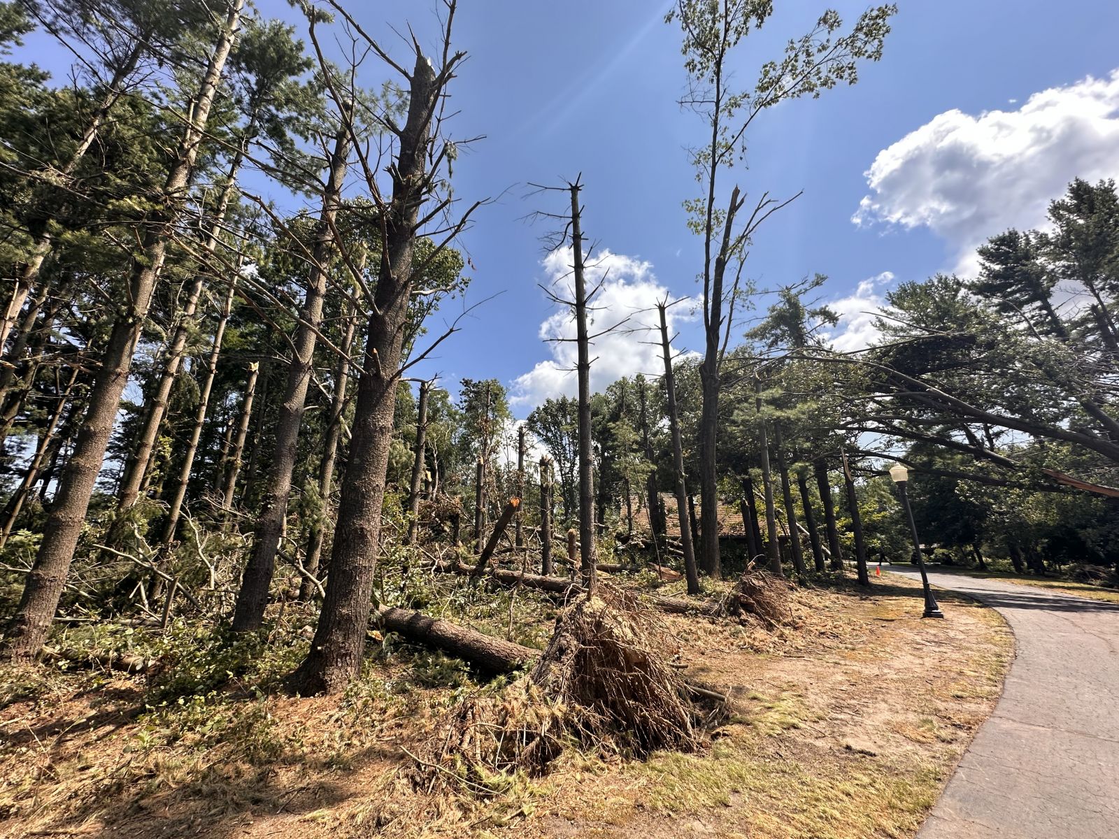
Ground view of extensive tree fall (NWS storm survey) |
Ground view of extensive tree fall (NWS Storm Survey) |
Radar
Header
 |
 |
 |
 |
|
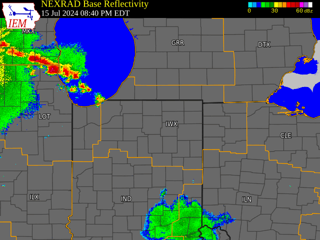
Radar loop from 9PM EDT July 15th to 5AM EDT July 16th. (IEM) |
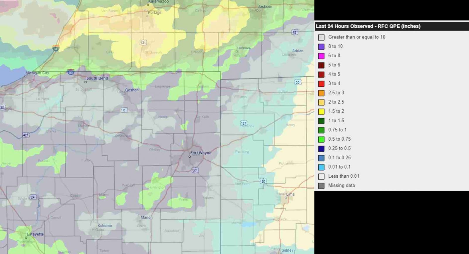
Initial radar estimate of rainfall via RFC. | Radar screen capture of the Elkhart tornado. Clockwise from top left: Base Reflectivity, Velocity, nROT (normalized Rotation), Correlation Coefficient. | Radar screen capture of the Marshall County tornado. Clockwise from top left: Base Reflectivity, Velocity, nROT (normalized Rotation), Correlation Coefficient |
Storm Reports
Preliminary Local Storm Report...Summary
National Weather Service Northern Indiana
1025 PM EDT Tue Jul 16 2024
..TIME... ...EVENT... ...CITY LOCATION... ...LAT.LON...
..DATE... ....MAG.... ..COUNTY LOCATION..ST.. ...SOURCE....
..REMARKS..
1105 PM Waterspout 2 NW Union Pier 41.85N 86.72W
07/15/2024 LMZ043 MI Public
A photo of a waterspout was captured and
shared via social media. Location and time
estimated by radar.
1132 PM Tornado 2 SSW Waterford 41.64N 86.86W
07/15/2024 La Porte IN NWS Storm Survey
A survey of damage confirmed a that a
tornado developed rapidly south of
Waterford, west of N 850 W and north of
Snyder Rd in LaPorte county. This tornado
intensified as it moved east northeast into
the Dianne Ct subdivision west of Wozniak
Rd. Further intensification was noted and
observed to the east between Wozniak and
Forrester roads. Here a private property
sustained widespread and severe tree damage
with several hundred mixed hardwood and
softwood trees uprooted and/or snapped on
this 20 acre property. Another concentrated
area of significant tree damage was noted
between Forrester Rd and Tiffany Dr. Many
homes and outbuildings sustained minor to
moderate damage from tree fall along this
track. This tornado continued east but
quickly weakened and ended west of Johnson
Rd as a larger scale microburst overtook the
tornado. Maximum winds were estimated at 100
mph with a maximum path width of 75 yards.
1158 PM Tstm Wnd Dmg 1 NE Westville 41.54N 86.90W
07/15/2024 La Porte IN Public
Delayed report of large tree limbs downed.
Time estimated from radar.
1209 AM Tornado 2 ESE Tippecanoe 41.20N 86.09W
07/16/2024 Marshall IN NWS Storm Survey
A survey of damage confirmed a brief
tornado, embedded within a larger area of
damaging winds. The tornado touched down
southwest of the intersection of 19th Rd and
Birch Rd, then moved northeast crossing 19th
Rd before lifting in a grove of trees.
Additional damage continued northeast to
along Apple Rd, but appeared to be from
straightline winds. Damage was confined to
several trees being snapped or uprooted in
the area. Maximum winds are estimated at 75
mph with a width of 75 yards.
1213 AM Tstm Wnd Dmg 1 WNW Wakarusa 41.54N 86.03W
07/16/2024 Elkhart IN Public
Delayed report of a large tree downed at a
residence. Time estimated from radar.
1218 AM Tstm Wnd Dmg 2 W Three Rivers 41.94N 85.68W
07/16/2024 St. Joseph MI Emergency Mngr
Delayed report of multiple trees down at
Meyer Broadway County Park. Time estimated
from radar.
1218 AM Tstm Wnd Gst 1 NNW Athens 41.07N 86.13W
07/16/2024 M71 MPH Fulton IN Mesonet
1220 AM Tstm Wnd Dmg 1 WSW Oakwood Park 41.41N 85.75W
07/16/2024 Kosciusko IN Public
Delayed report of large tree limbs down on
Syracuse Webster Road. Time estimated from
radar.
1221 AM Tornado 2 S Elkhart 41.67N 85.97W
07/16/2024 Elkhart IN NWS Storm Survey
A survey of damage confirmed a brief EF1
tornado, embedded within an area of
straightline wind damage. The tornado
touched down southeast of Hawthorne
Elementary School and proceeded quickly ESE,
eventually lifting near the intersection of
Bismark Rd and S Main St. Numerous trees
were uprooted, partially due to the wet
ground conditions, as well as several
snapped tree limbs and trunks. The greatest
damage occurred in the area of Mather Ave,
between Carlton Ave and Naomi St. Winds were
estimated in the 85 to 90 mph range with a
maximum width of 250 yards.
1223 AM Tstm Wnd Dmg 2 WNW Benton 41.53N 85.80W
07/16/2024 Elkhart IN Public
Corrects time of previous tstm wnd dmg
report from 2 WNW Benton. Trees and
powerlines down near the Goshen Municipal
Airport. Several reports on social media.
Time estimated via radar.
1223 AM Tstm Wnd Dmg 3 SE Dunlap 41.61N 85.88W
07/16/2024 Elkhart IN Trained Spotter
Report of Twitter of numerous trees and
limbs down in the Brookside Mobile Home
Park. Time estimated from radar.
1224 AM Tstm Wnd Dmg 1 SSE Three Rivers 41.93N 85.63W
07/16/2024 St. Joseph MI Emergency Mngr
Delayed report. A few trees down near South
Main Street. Time estimated from radar.
1226 AM Tstm Wnd Dmg 1 ENE Benton 41.51N 85.75W
07/16/2024 Elkhart IN Public
Photo on Twitter of a large barn with one
wall collapsed and a partial roof collapse.
Trusses still standing on one-quarter of the
roof. Barn door in photo is open, or missing
in the photo. Location is approximate. Time
estimated from radar.
1258 AM Tstm Wnd Dmg 1 NNW Kendallville 41.45N 85.26W
07/16/2024 Noble IN Public
Delayed report of large tree limbs downed on
north side of Kendallville. Time estimated
from radar.
1258 AM Tstm Wnd Dmg 3 SE Arcola 41.08N 85.25W
07/16/2024 Allen IN Public
Delayed report of large tree limbs down near
Illinois Road between Scott and Hadley
roads. Time estimated from radar.
0100 AM Tstm Wnd Dmg Crooked Lake 41.68N 85.04W
07/16/2024 Steuben IN Public
Delayed report. Power line downed near a
residence. Time estimated from radar.
0108 AM Tstm Wnd Dmg Hudson 41.54N 85.08W
07/16/2024 Steuben IN Public
Delayed report of large tree limbs downed at
a residence. Time estimated from radar.
0118 AM Tstm Wnd Dmg Auburn 41.37N 85.06W
07/16/2024 De Kalb IN Broadcast Media
Photo on Twitter shows large tree down onto
a covered porch. Porch roof collapsed. Time
estimated from radar. Location approximate.
0140 AM Tstm Wnd Dmg 2 S Van Wert 40.84N 84.58W
07/16/2024 Van Wert OH Public
Delayed report of tree down on US Route 127
just south of Van Wert. Time estimated from
radar.
0452 AM Tstm Wnd Dmg 4 SSW Big Long Lake 41.51N 85.28W
07/16/2024 Noble IN Broadcast Media
Photos on Twitter of numerous large branches
down and a couple trees down near Cree Lake.
Time estimated from radar.
1035 PM Tstm Wnd Dmg 1 NW Watervliet 42.19N 86.27W
07/15/2024 Berrien MI Trained Spotter
Trained spotter estimates wind gusts to 50
mph with several medium to large tree limbs
down in the Watervliet area. One large tree
limb onto powerlines. Time estimated from
radar.
1040 PM Tstm Wnd Dmg 3 SE Waterford 41.64N 86.80W
07/15/2024 La Porte IN Trained Spotter
Large tree down on a car (no injuries) and
narrowly missed a home. Time provided by
spotter.
1130 PM Tstm Wnd Dmg La Porte 41.61N 86.72W
07/15/2024 La Porte IN Public
Photo of large tree down onto car (no
injuries) in La Porte. Time provided in
report on Facebook.
1140 PM Tstm Wnd Dmg 2 SW La Porte 41.59N 86.74W
07/15/2024 La Porte IN Public
Reports of numerous small to medium sized
branches down southwest of La Porte. Time
estimated via radar.
1140 PM Tstm Wnd Dmg 3 SE Waterford 41.64N 86.80W
07/15/2024 La Porte IN Trained Spotter
Corrects time of previous tstm wnd dmg
report from CDT to EDT from 3 SE Waterford.
Large tree down on a car (no injuries) and
narrowly missed a home. Time provided by
spotter.
1140 PM Tstm Wnd Dmg Waterford 41.67N 86.85W
07/15/2024 La Porte IN Public
Powerlines down in Waterford with power
outages being reported. Time estimated from
radar.
1142 PM Tstm Wnd Dmg 2 SE Waterford 41.65N 86.81W
07/15/2024 La Porte IN Trained Spotter
Trained spotter reports damage on the
northwest side of La Porte in the vicinity
of Johnson Rd and CR 300 N. Trees and
powerlines down. Possible tornado damage.
Time estimated via radar.
1144 PM Tstm Wnd Dmg Winamac 41.05N 86.60W
07/15/2024 Pulaski IN Public
Large tree down and blocking E Hutchinson Rd
in Winamac. Time estimated from radar.
1152 PM Tstm Wnd Dmg 3 WNW Chain-O-Lakes 41.73N 86.43W
07/15/2024 St. Joseph IN Law Enforcement
Police reports large tree down and blocking
Tamarack Road near New Carlisle. Time
estimated from radar.
1155 PM Tstm Wnd Dmg 1 SSW La Paz 41.45N 86.32W
07/15/2024 Marshall IN Dept of Highways
Corrects previous tstm wnd dmg report from 1
SSW La Paz. Downed powerlines on US 6 in La
Paz. Time estimated via radar. INDOT reports
all lanes are blocked and closed until 3 AM
EDT.
1155 PM Tstm Wnd Dmg Plymouth 41.35N 86.32W
07/15/2024 Marshall IN Emergency Mngr
Emergency manager reports four trees down
with power lines on Nutmeg just south of
Menominee Elementary in Plymouth. Time
estimated via radar.
1200 AM Tstm Wnd Dmg Argos 41.24N 86.25W
07/16/2024 Marshall IN Public
Large limbs down on Kenilworth Rd in Argos.
Time estimated from radar.
1200 AM Lightning Middlebury 41.67N 85.71W
07/16/2024 Elkhart IN Public
Photo on Facebook showing a grove of trees
on fire due to a lightning strike. Public
reports this occurred around midnight EDT in
Middlebury.
1202 AM Tstm Wnd Dmg 2 NNW Twin Lakes 41.33N 86.38W
07/16/2024 Marshall IN Public
Tree down blocking IN 17 near the Plymouth
golf course. Time estimated via radar.
1202 AM Tstm Wnd Dmg Walnut 41.18N 86.21W
07/16/2024 Marshall IN Public
Tree down on 20th Street between Ironwood
and Hickory. Time estimated via radar.
1202 AM Tstm Wnd Dmg Walnut 41.18N 86.21W
07/16/2024 Marshall IN Public
Large tree and smaller limbs down at
Ironwood Road and 20C. Time estimated via
radar.
1208 AM Tstm Wnd Dmg 2 SW Locke 41.45N 86.04W
07/16/2024 Elkhart IN Public
Large tree limbs down west of Nappanee. Time
estimated via radar.
1211 AM Tstm Wnd Dmg Nappanee 41.45N 85.98W
07/16/2024 Elkhart IN Public
Large tree down onto home in Nappanee. No
reported injuries at this time. Time
estimated via radar.
1213 AM Tstm Wnd Dmg 1 SSW Mishawaka 41.65N 86.18W
07/16/2024 St. Joseph IN Public
Tree uprooted on East 11th Street in
Mishawaka. Time estimated via radar.
1213 AM Tstm Wnd Dmg Granger 41.74N 86.14W
07/16/2024 St. Joseph IN Public
Three large evergreen trees down and power
outages reported. Time estimated from radar.
1215 AM Tstm Wnd Dmg Mishawaka 41.67N 86.17W
07/16/2024 St. Joseph IN Public
Loss of siding on a home in Mishawaka. Photo
and time provided in a Facebook report.
1217 AM Tstm Wnd Dmg Logansport 40.76N 86.36W
07/16/2024 Cass IN Emergency Mngr
1225 S and 800 E tree down blocking roadway
per emergency manager. Time estimated via
radar.
1218 AM Tstm Wnd Dmg 2 ENE Logansport 40.76N 86.33W
07/16/2024 Cass IN Public
Emergency manager reports tree down on High
St at Roselawn and 22nd streets. Time
estimated via radar.
1218 AM Tstm Wnd Dmg 1 SSE Adamsboro 40.76N 86.26W
07/16/2024 Cass IN Emergency Mngr
Tree down and powerlines down at County Road
600 E and Logansport Road. Time estimated by
radar.
1220 AM Tstm Wnd Dmg 3 NE Logansport 40.78N 86.33W
07/16/2024 Cass IN Emergency Mngr
Tree down just north of the intersection of
county road 250 E and 125 N. Time estimated
via radar.
1221 AM Tstm Wnd Dmg Winona Lake 41.22N 85.81W
07/16/2024 Kosciusko IN Public
Large tree limb down. Time estimated from
radar.
1222 AM Tstm Wnd Dmg 2 S Elkhart 41.66N 85.97W
07/16/2024 Elkhart IN Public
Several trees down near the Kroger on the
south side of Elkhart. Time estimated via
radar.
1223 AM Tstm Wnd Dmg Royal Center 40.87N 86.50W
07/16/2024 Cass IN Emergency Mngr
Report from Emergency Manager of large tree
limb blown down near the center of Royal
Center, Indiana in Cass County.
1225 AM Tstm Wnd Dmg 2 S Elkhart 41.66N 85.97W
07/16/2024 Elkhart IN Fire Dept/Rescue
Elkhart Fire Department reports damage from
Southdale St. to Main St. between East
Lusher Ave. and East Hively Ave in southern
Elkhart. Possible tornado damage. Time
estimated via radar.
1227 AM Tstm Wnd Dmg 2 NE Sidney 41.13N 85.71W
07/16/2024 Kosciusko IN Public
Large tree down on a house south of
Pierceton.
1229 AM Tstm Wnd Dmg 1 NE Lake Wawasee 41.41N 85.69W
07/16/2024 Kosciusko IN Public
Several large trees uprooted on Ogden Point
Rd on Lake Wawasee. Also damage to a few
boat lifts on the lake. Time estimated from
radar.
1229 AM Tstm Wnd Dmg Lake Wawasee 41.40N 85.70W
07/16/2024 Kosciusko IN Public
Multiple trees down and one fell across the
channel blocking the water way, per public
report on X/Twitter. Time estimated via
radar.
1229 AM Tstm Wnd Dmg 1 ENE Warsaw 41.24N 85.83W
07/16/2024 Kosciusko IN Emergency Mngr
Emergency Manager reports tree down at Lake
Street in Warsaw Indiana and loss of power
over east Warsaw Indiana in Kosciusko
County.
1230 AM Tstm Wnd Dmg Peru 40.76N 86.07W
07/16/2024 Miami IN Trained Spotter
Powerlines down and several power flashes
observed in Peru, IN.
1230 AM Tstm Wnd Dmg Peru 40.75N 86.07W
07/16/2024 Miami IN Public
Powerlines down in Peru. Time estimated from
radar.
1231 AM Tstm Wnd Dmg Walton 40.66N 86.24W
07/16/2024 Cass IN Emergency Mngr
Tree down on Grace St between Depot and Main
Street. Reported by emergency manager. Time
estimated via radar.
1235 AM Tstm Wnd Dmg Loon Lake 41.28N 85.54W
07/16/2024 Whitley IN Public
Tree down on home in Loon Lake. No injuries
reported. Time estimated via radar.
1239 AM Tstm Wnd Dmg Wabash 40.80N 85.82W
07/16/2024 Wabash IN Public
Large tree down in Wabash onto powerlines,
narrowly missing a house. Time estimated via
radar.
1239 AM Tstm Wnd Dmg 2 ESE Ridinger Lake 41.25N 85.62W
07/16/2024 Whitley IN Fire Dept/Rescue
Fire Department enroute to reports of a tree
into a house in Northwestern Whitley County.
No reported injuries at this time.
1240 AM Tstm Wnd Dmg Walton 40.66N 86.24W
07/16/2024 Cass IN Emergency Mngr
Emergency manager reports tree downed at
Grace street between Depot and Main street
in Walton, Indiana in Cass County.
1244 AM Tstm Wnd Dmg Columbia City 41.16N 85.49W
07/16/2024 Whitley IN Fire Dept/Rescue
Tree into house confirmed by on-scene fire
personnel. 2500 West Block of 700 North
Columbia City. Unknown if any injuries.
1249 AM Tstm Wnd Dmg Logansport 40.76N 86.35W
07/16/2024 Cass IN Emergency Mngr
Emergency manager reports multiple trees
downed near High Street at Roselawn and at
22 street in Logansport Indiana in Cass
County.
1252 AM Tstm Wnd Dmg 2 S Adamsboro 40.76N 86.26W
07/16/2024 Cass IN Emergency Mngr
Emergency Manager reports tree and power
lines down at 600 E and Logansport Road east
of Logansport, Indiana in Cass County.
1252 AM Tstm Wnd Dmg 1 E Huntington 40.88N 85.48W
07/16/2024 Huntington IN Emergency Mngr
Tree reported down on East side of town on
Grayston Avenue. Time estimated via radar.
1255 AM Tstm Wnd Dmg Lancaster 40.74N 85.51W
07/16/2024 Huntington IN Emergency Mngr
Tree down on 300W in Lancaster. Time
estimated via radar.
0103 AM Tstm Wnd Dmg 2 NNW Fort Wayne 41.10N 85.15W
07/16/2024 Allen IN Broadcast Media
Broadcast media relayed photos of tree limbs
and powerlines down at the intersection of W
State and Sherman in Fort Wayne. Time
estimated via radar.
0105 AM Tstm Wnd Dmg 4 S Fort Wayne 41.02N 85.14W
07/16/2024 Allen IN Trained Spotter
Trained Spotter reports a tree down on S.
Calhoun and Tillman Roads in Fort Wayne,
Tree across the road. Healthy tree 10-12 in
diameter. Time estimated from radar.
0108 AM Tstm Wnd Dmg 3 SSE Fort Wayne 41.04N 85.12W
07/16/2024 Allen IN Broadcast Media
Broadcast media relays report from dispatch
of a large tree uprooted on Smith Street.
Time estimated via radar.
0108 AM Tstm Wnd Dmg 2 NE Fort Wayne 41.09N 85.11W
07/16/2024 Allen IN Broadcast Media
Broadcast media relays dispatch report of
tree limbs and powerlines down on Randalia &
Delaware in Fort Wayne. Time estimated via
radar.
0109 AM Tstm Wnd Dmg 3 SE Wallen 41.13N 85.12W
07/16/2024 Allen IN Trained Spotter
Trained spotter reports tree down at the
intersection of Clinton Rd and Washington
Center Rd. Estimated 50 mph wind gusts.
0115 AM Tstm Wnd Dmg 2 SW Angola 41.62N 85.02W
07/16/2024 Steuben IN Emergency Mngr
Power lines down on Fox Lake Road southwest
of Angola. Time estimated via radar.
0115 AM Tstm Wnd Dmg 2 W Silver Lake 41.63N 85.10W
07/16/2024 Steuben IN Fire Dept/Rescue
Local fire department reports tree down on
CR 600 W and CR 100 N west of Angola.
0115 AM Tstm Wnd Dmg Angola 41.64N 85.00W
07/16/2024 Steuben IN Law Enforcement
A tree was reported down across the street
in Angola by local law enforcement. Tree is
on Joe Wheeler Street, between Broad St. and
W. Maumee. Unknown diameter. Report relayed
by emergency manager.
0116 AM Tstm Wnd Dmg 3 NE Logansport 40.78N 86.33W
07/16/2024 Cass IN Emergency Mngr
Emergency manager reports tree down at
Country Road 250 E and 125 N, northeast of
Logansport Indiana in Cass County.
0117 AM Tstm Wnd Dmg 2 ESE Ridinger Lake 41.25N 85.63W
07/16/2024 Whitley IN Emergency Mngr
Emergency manager reports a tree blown down
into a house in northwest Whitley County
Indiana no injuries reported at this time.
0118 AM Tstm Wnd Dmg 1 WNW Auburn 41.37N 85.08W
07/16/2024 De Kalb IN Law Enforcement
*** 1 INJ ***
Corrects location of previous tstm wnd dmg
report from 1 WNW Auburn. State Police
reported a semi-truck driver with injury
when tree fell onto the cab of the truck
near Auburn in De Kalb County in Indiana.
Occurred on Southbound I-69, MM 323 in
DeKalb County.
0122 AM Tstm Wnd Dmg 2 ENE Huntington 40.89N 85.48W
07/16/2024 Huntington IN Public
Emergency manager reports tree blown down on
east side of Huntington, Indiana on Grayston
Avenue in Huntington County.
0130 AM Tstm Wnd Dmg 2 WNW New Waverly 40.78N 86.23W
07/16/2024 Cass IN Emergency Mngr
Emergency Manager reports a tree downed over
road near 800 E and 100 N east of Logansport
Indiana in Cass County.
0147 AM Tstm Wnd Dmg 2 ESE Cavett 40.93N 84.54W
07/16/2024 Van Wert OH Emergency Mngr
Tree down on Fife Rd.
Public Information Statement
National Weather Service Northern Indiana
405 AM EDT Tue Jul 16 2024

...HIGHEST WIND REPORTS...

Location                     Speed     Time/Date       Provider

...Indiana...

...Adams County...
Decatur                      41 MPH    0120 AM 07/16   DAVIS

...Allen County...
5 N New Haven                62 MPH    0110 AM 07/16   Trained Spotter
Fort Wayne International Ap  54 MPH    0109 AM 07/16   ASOS
1 SE Wallen                  46 MPH    0115 AM 07/16   AWOS

...Cass County...
3 SW Lincoln                 67 MPH    1233 AM 07/16   Mesonet
Walton                       44 MPH    1230 AM 07/16   CWOP

...Fulton County...
1 NNW Athens                 71 MPH    1218 AM 07/16   Mesonet
Rochester                    47 MPH    1215 AM 07/16   AWOS

...Grant County...
Grant County Municipal Apt   44 MPH    0115 AM 07/16   AWOS

...Huntington County...
Huntington                   41 MPH    0103 AM 07/16   CWOP

...Kosciusko County...
1 SW Burket                  59 MPH    1219 AM 07/16   Mesonet

...La Porte County...
La Porte                     47 MPH    1238 AM 07/16   AWOS

...Marshall County...
Asel                         45 MPH    1150 PM 07/15   MESOWEST
Grand Beach                  42 MPH    1115 PM 07/15   DAVIS

...Miami County...
Grissom AFB Peru             48 MPH    1239 AM 07/16   AWOS

...St. Joseph County...
South Bend International Ap  40 MPH    1200 AM 07/16   ASOS

...Steuben County...
Angola                       51 MPH    0115 AM 07/16   AWOS

...White County...
Monticello - White County Ar 40 MPH    1215 AM 07/16   AWOS

...Michigan...

...Berrien County...
1 ENE Riverside              50 MPH    1030 PM 07/15   Trained Spotter
1 NE Coloma                  50 MPH    1030 PM 07/15   Trained Spotter
St Joseph Marine Station     41 MPH    1020 PM 07/15   MESOWEST
Benton Harbor                40 MPH    1101 PM 07/15   ASOS

...St. Joseph County...
Sturgis Kirsch               46 MPH    1232 AM 07/16   AWOS

...Ohio...

...Allen County...
Lima 1 N                     41 MPH    0223 AM 07/16   CWOP

...Defiance County...
Defiance                     45 MPH    0148 AM 07/16   ASOS
Ney                          41 MPH    0145 AM 07/16   DAVIS

...Putnam County...
Kalida                       41 MPH    0215 AM 07/16   CWOP

...Van Wert County...
Van Wert                     53 MPH    0142 AM 07/16   Emergency Mngr
4 NNW Jonestown              52 MPH    0147 AM 07/16   Public
3 S Van Wert                 45 MPH    0145 AM 07/16   Emergency Mngr
Van Wert                     40 MPH    0150 AM 07/16   CWOP

...Indiana...

...Maritime Stations...
5 WNW Long Beach             56 MPH    1130 PM 07/15   Public

...Michigan...
4 NW Bridgman                51 MPH    1200 AM 07/16   NDBC
Environment
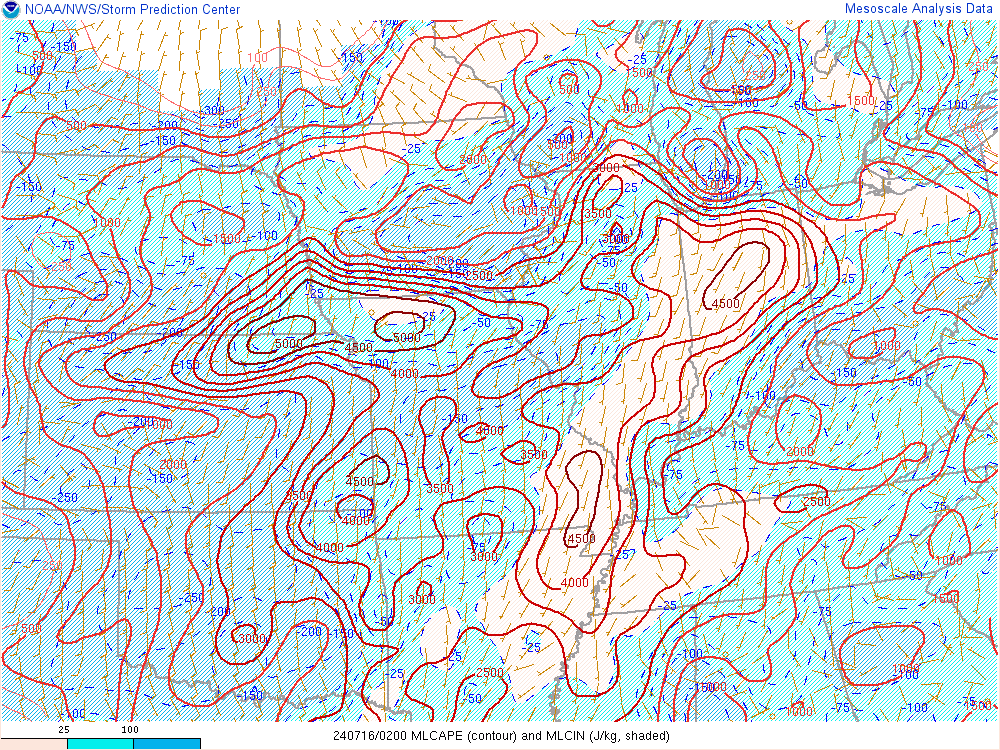
Storms entered Indiana and southwest Lower Michigan around 02Z on July 16th and had weakened into northwest Ohio by 06Z. The environment ahead of and along the large complex of severe storms was very favorable. MLCAPE had been increasing throughout the afternoon/evening, and was up to 3000 to 5000 J/kg by 02Z (Figure 1) in northern Indiana. 0-6 km shear had increased to 25 to 35 kts (Figure 3).
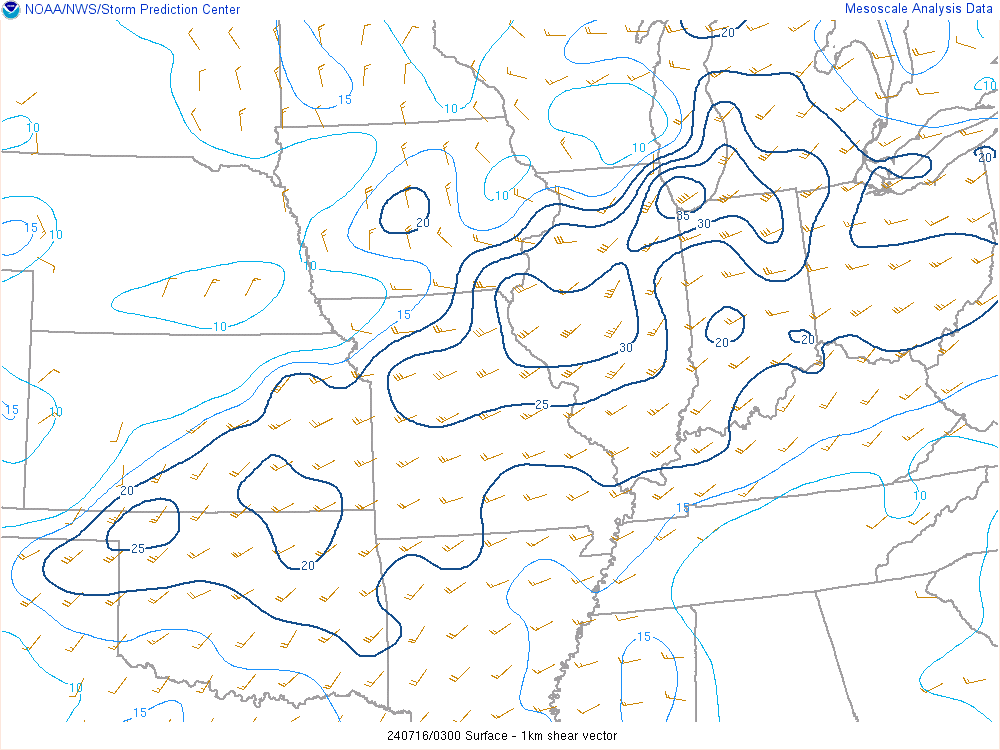
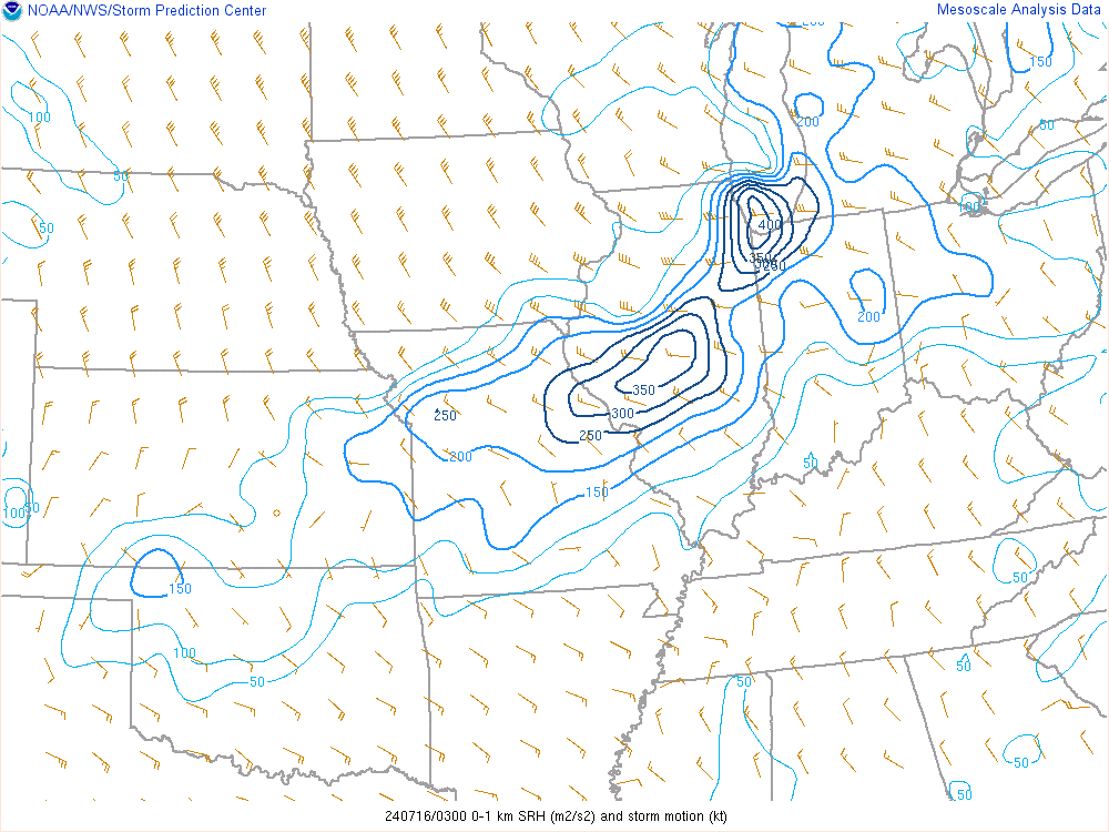
By 03Z, there was decent potential for tornadoes as well (Figures 7 & 8) as there was strong 0-1 km shear of 25 to 35 kts and widespread 150 m2/s2 of 0-1 km SRH across much of the area. 0-1 km SRH was as high as 350 to 400 m2/s2 closer to Lake Michigan.
There was also isolated to scattered instances of flooding/flash flooding possible within this severe setup. Soundings and SPC mesoanalysis showed extreme PWATs 2 to 2.25" (Figure 6), a very deep warm cloud layer of up to 15,000 ft, and a favorable vertical CAPE profile.
 |
 |
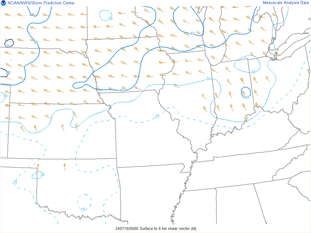 |
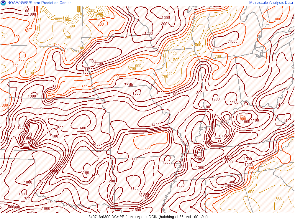
| Figure 1: 02Z July 16th - MLCAPE of 3000 to 5000 J/kg across northern/north central Indiana | Figure 2: 03Z July 16th - between 800 to 1200 J/kg DCAPE | Figure 3: 01Z 0-6 km shear had increased to 25 to 30 kts |
 |
 |
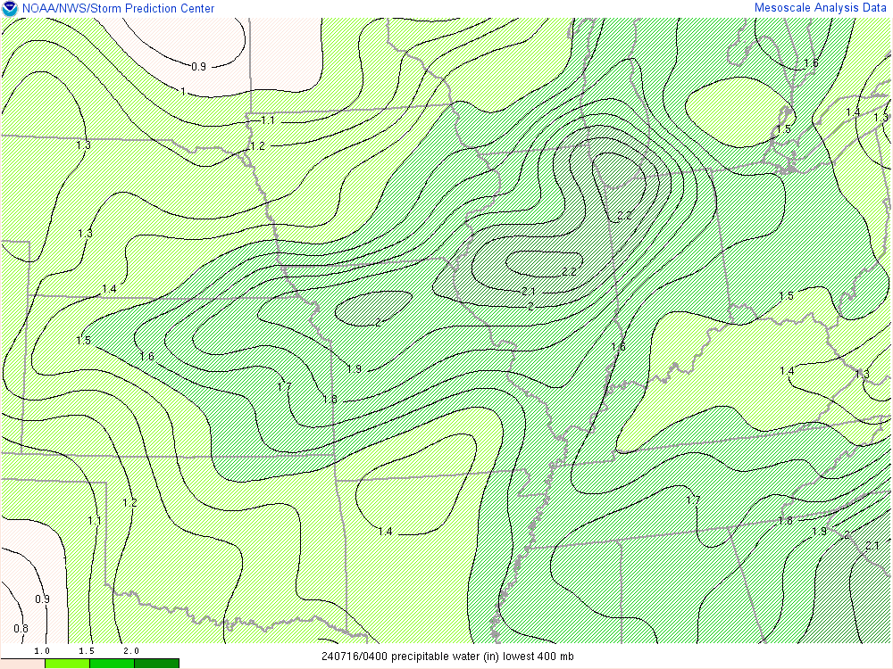 |
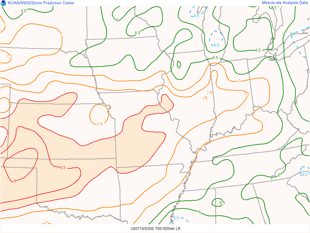
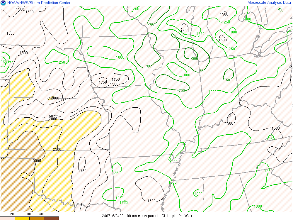
| Figure 4: 03Z July 16th - moderately steep mid level lapse rates of up to 7C/km | Figure 5: 04Z July 16th - LCL heights were between 750 to 1000 meters | Figure 6: 04Z Precipitable Water - PWATs were near record to record high for this day around 2" |
 |
 |
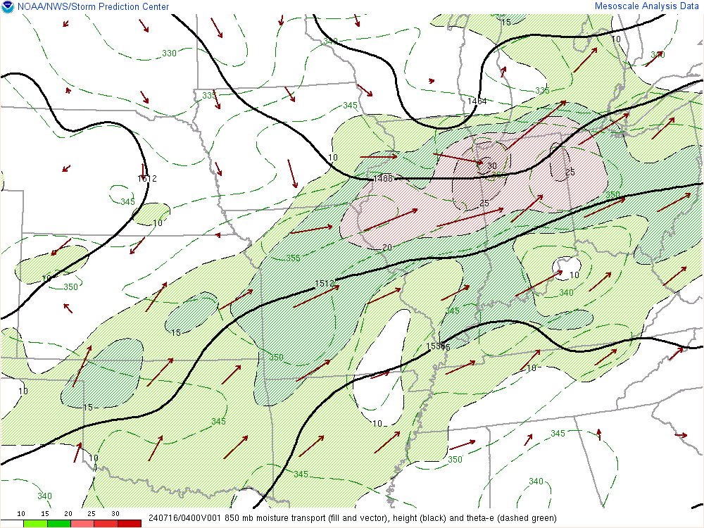 |
| Figure 7: 03Z July 16th - 0-1 km shear was very favorable at 25 to 35 kts | Figure 8: 03Z July 16th - 0-1 km SRH was very favorable along the line of storms up to 300-400 m2/s2 | Figure 9: 04Z 850mb moisture transport |
 |
Media use of NWS Web News Stories is encouraged! Please acknowledge the NWS as the source of any news information accessed from this site. |
|