Overview
|
Several rounds of strong to severe storms impacted the area starting during the evening hours of July 28 and continuing into the early morning hours of July 29th. Storms were more scattered with the initial round, before a stronger second round consisting of a Bow Echo moved trough early in the morning of July 29th. The highest measured wind speed during this event was 74 MPH at the Grissom Air Force Base in Cass/Miami counties. Numerous reports were received of damage to trees, tree limbs, structures, power lines and poles across northern Indiana and northwest Ohio. Assessment of the damage continues in some areas, with additional updates and changes forthcoming over the next day or two. As of 3 PM July 30th, two tornadoes have been confirmed from this event. The latest details can be found in the most recent Public Information Statement.
|
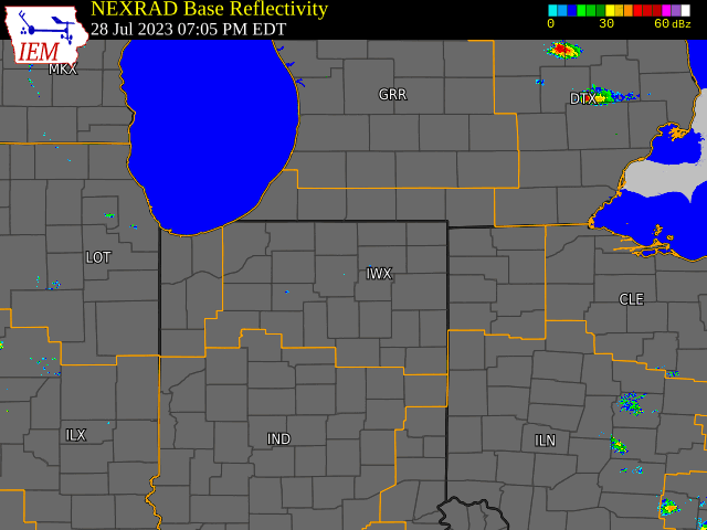
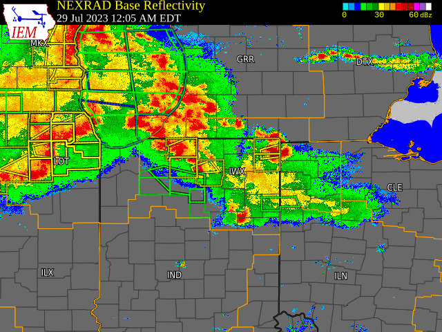
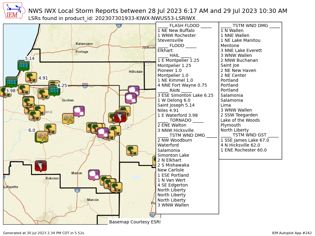 A map of hail, flood, wind gusts, and wind damage reports from the evening of July 28th into the morning of July 29th |
Tornadoes:
|
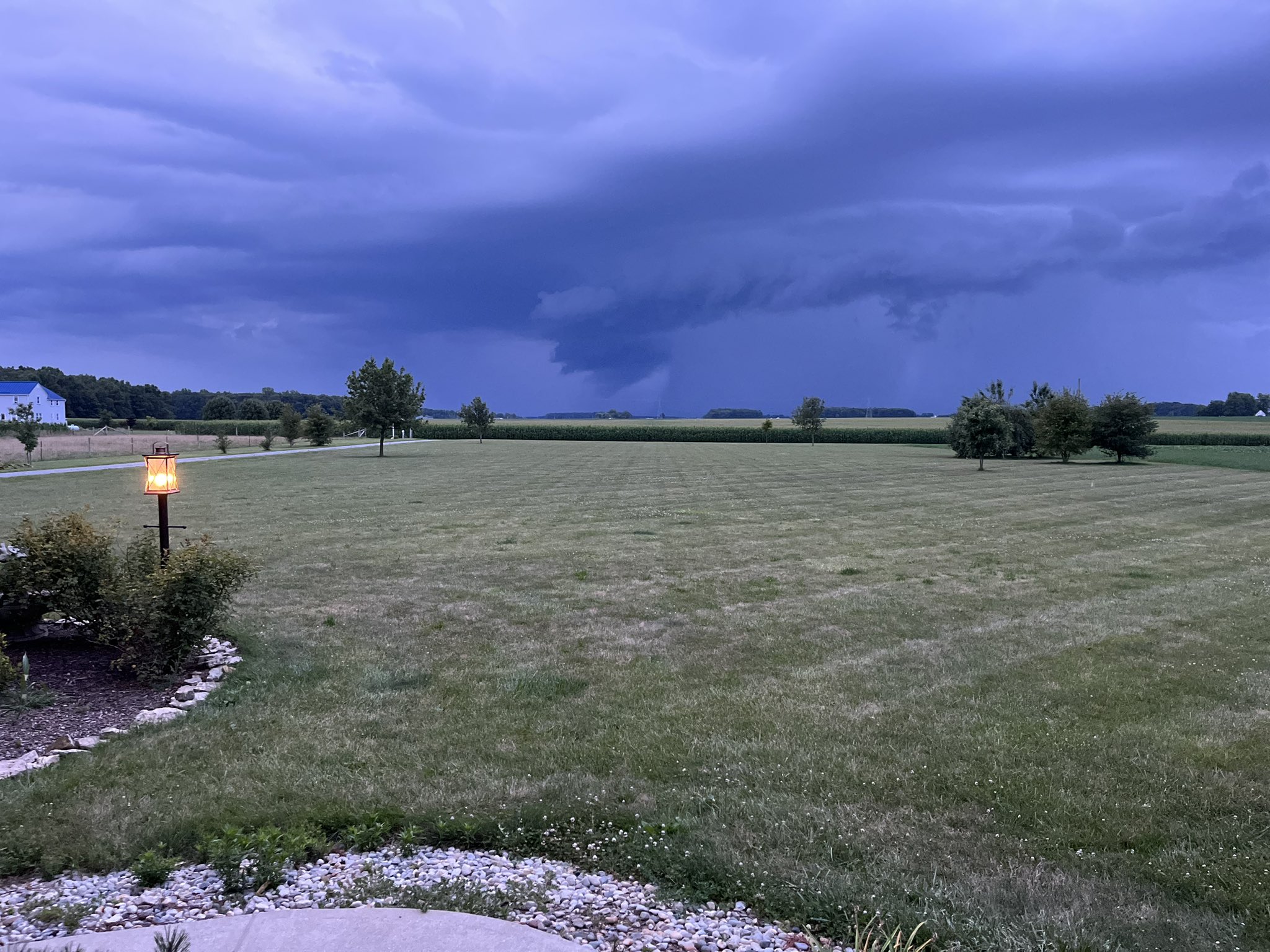
Tornado - Walton, IN
|
||||||||||||||||
|
Tornado - 3 S Churubusco, IN
|
||||||||||||||||
|
Tornado - Hicksville OH
|
||||||||||||||||
The Enhanced Fujita (EF) Scale classifies tornadoes into the following categories:
| EF0 Weak 65-85 mph |
EF1 Moderate 86-110 mph |
EF2 Significant 111-135 mph |
EF3 Severe 136-165 mph |
EF4 Extreme 166-200 mph |
EF5 Catastrophic 200+ mph |
 |
|||||
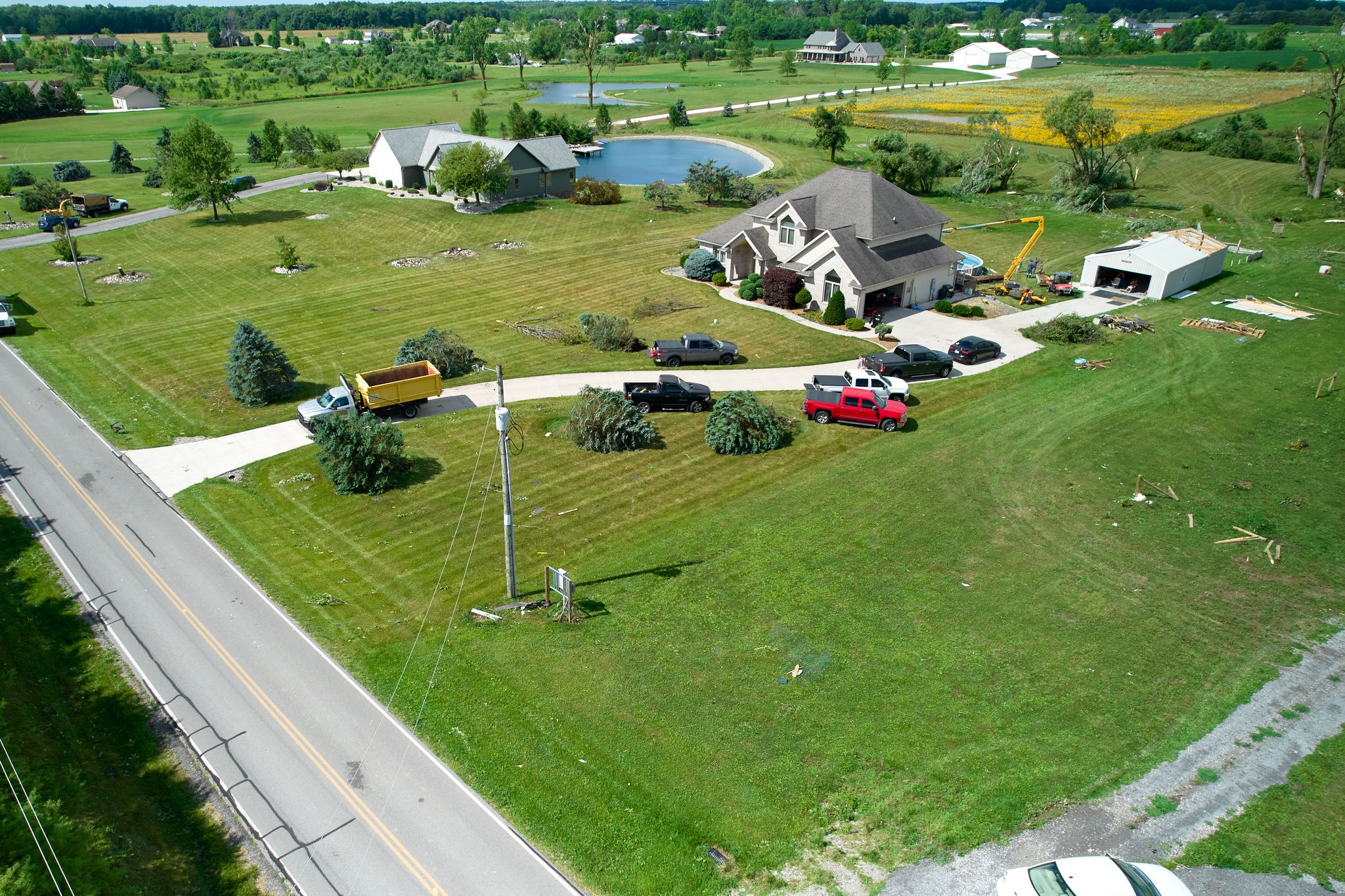
Photos & Videos
| Bow echo bears down on North Webster, IN (NWS IWX) |
Shopping carts go flying in Fort Wayne (Jordan Stackhouse - Indiana Storm Chasers) |
 |
 |
 |
| Cap breaks into towering cumulonimbus near Metea, IN (Ethan B.) |
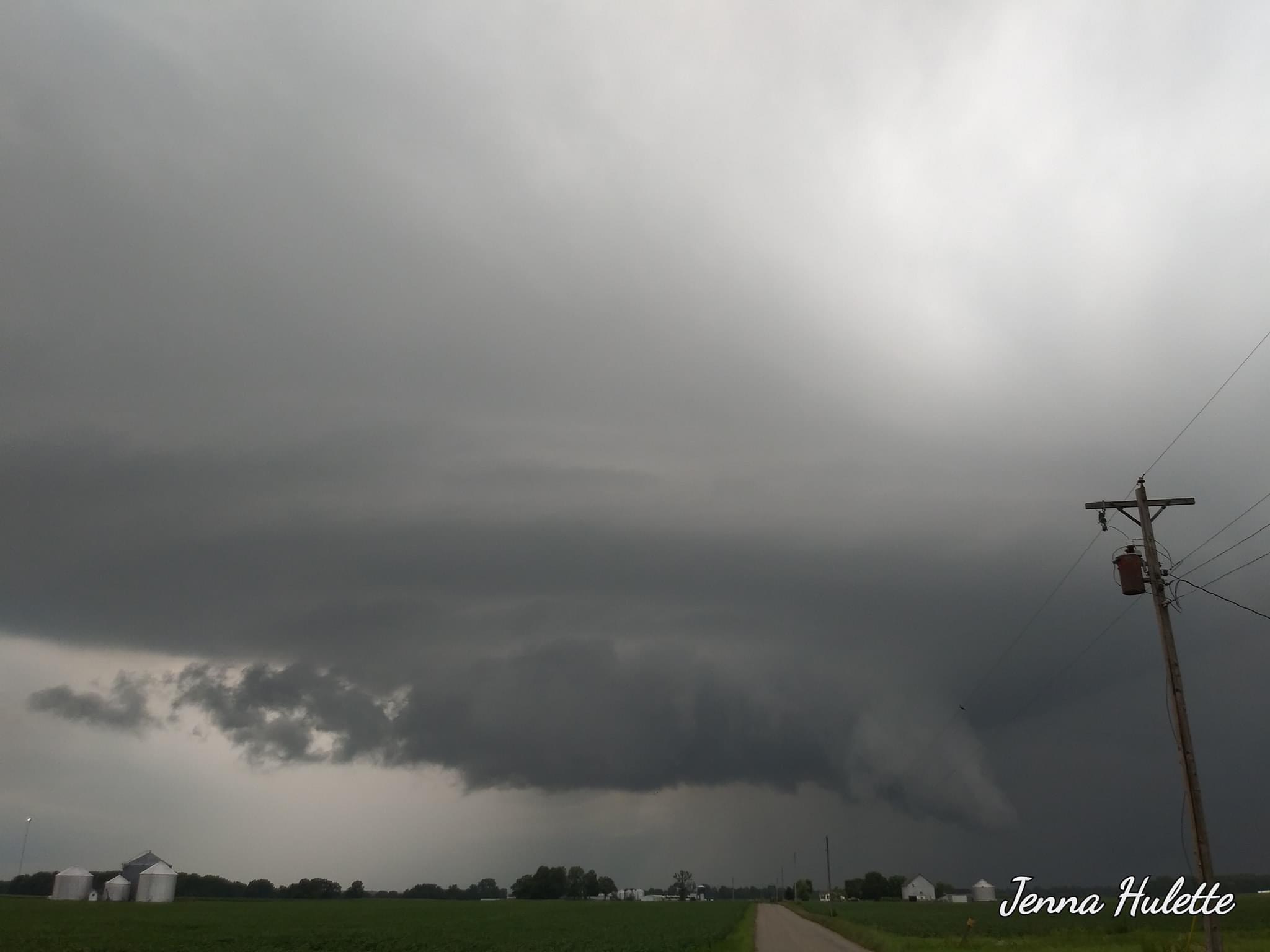
Wall cloud near Logansport, IN (Jenna Hulette) |
Massive shelf cloud descends upon North Webster, IN (NWS IWX) |
 |
 |
 |
 |
| The view from Monroeville as a shelf cloud moved across the sky. (Christy - christinacz7 on X/Twitter) |
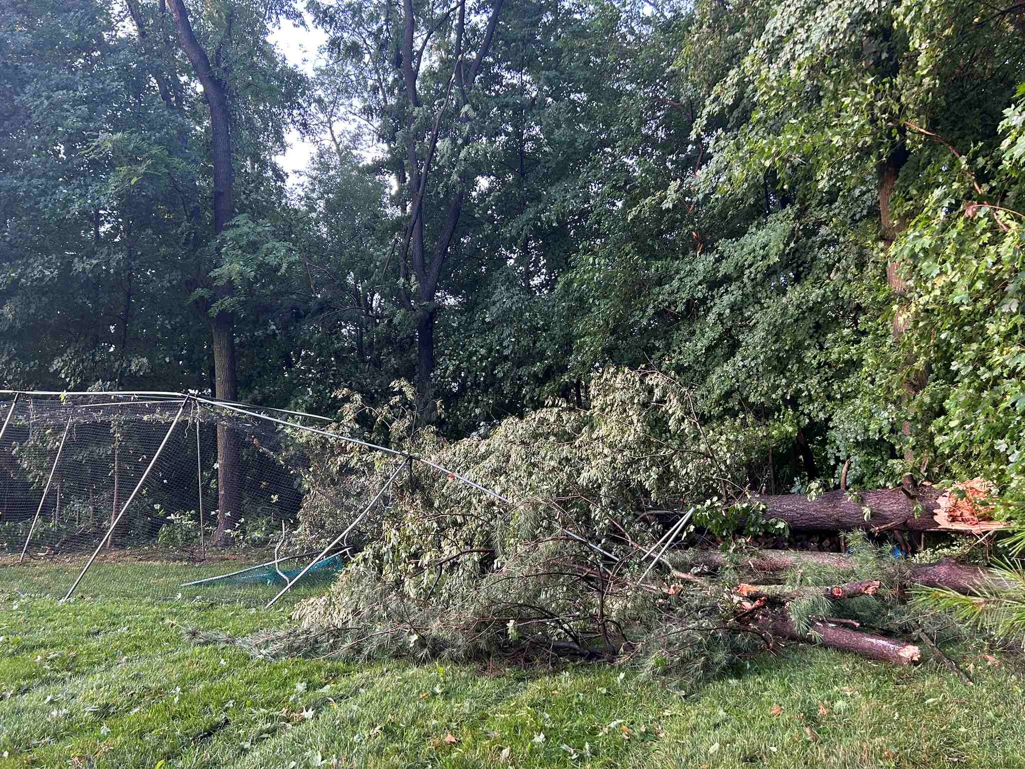
Large tree down in North Liberty, IN (Tom Coomes - ABC57 News) |
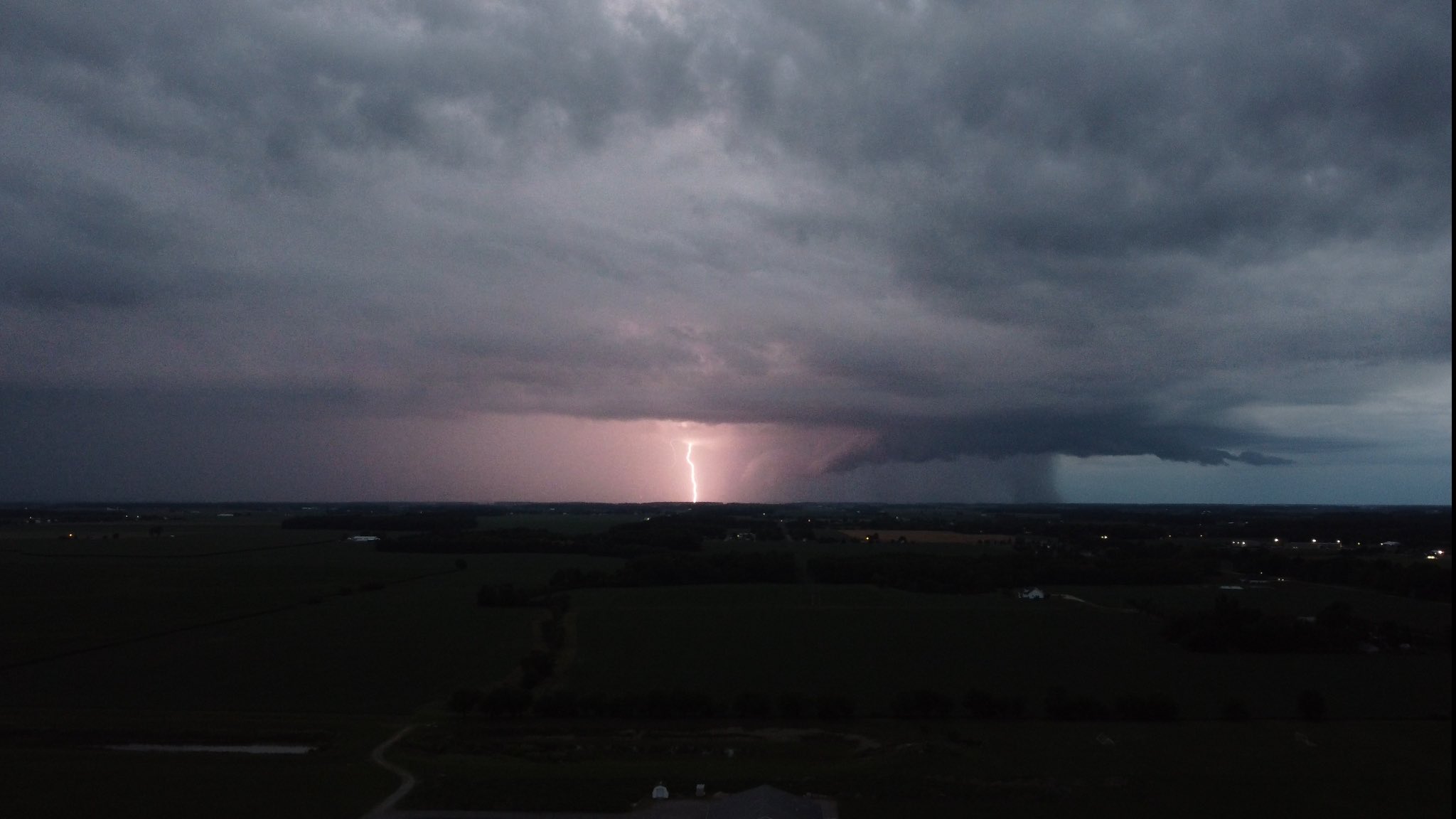
Vivid lightning captured near Van Wert, OH (Matt Saunier - msaunierld on X/Twitter) |
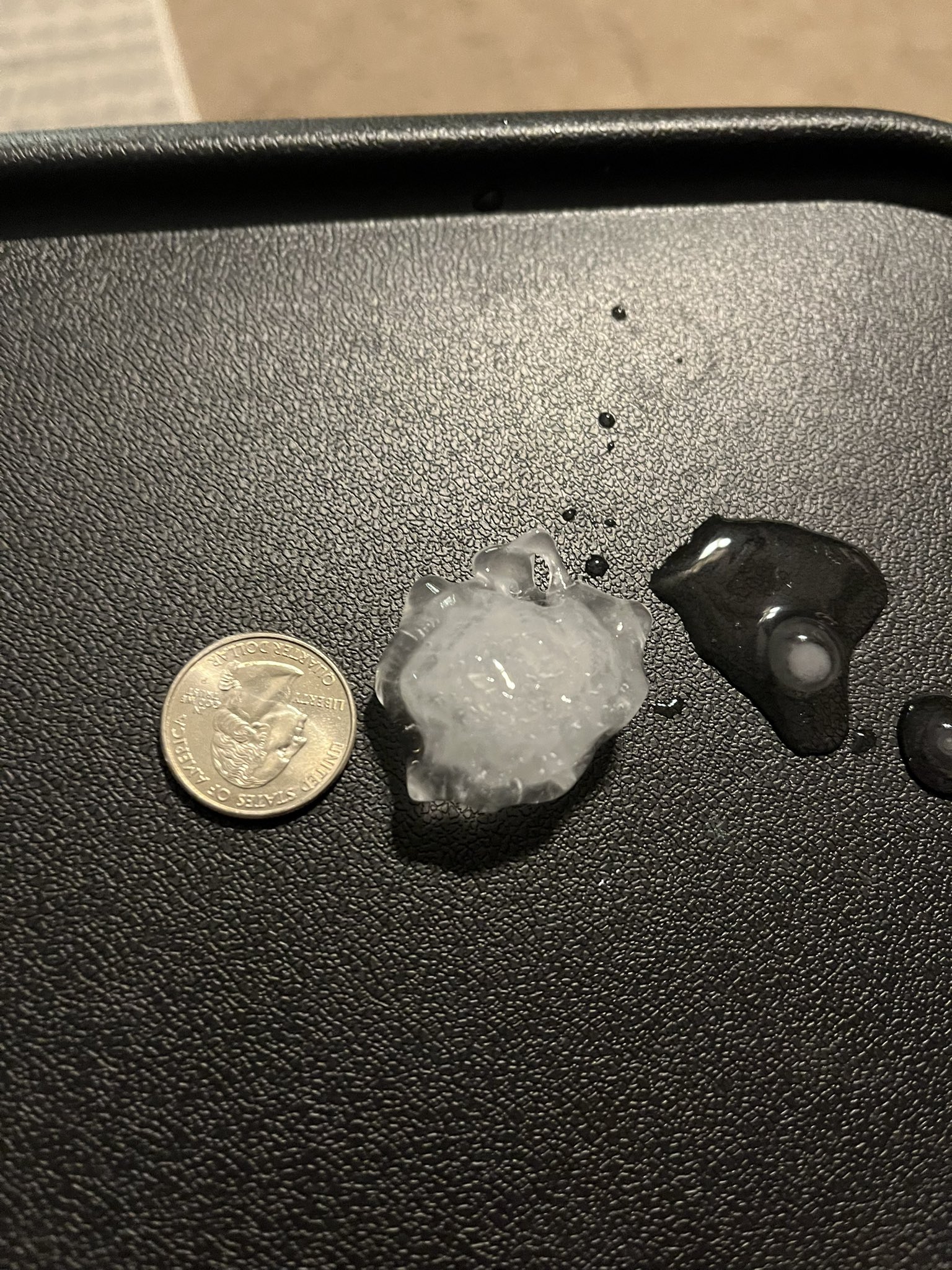
At least quarter sized hail in Ligonier (Caitlyn Jacob - caitlynjacob18 on X/Twitter) |
 |
 |
 |
 |
| Trees down in Rochester, IN (Brayden Zink - ZinkBrayden on X/Twitter) |
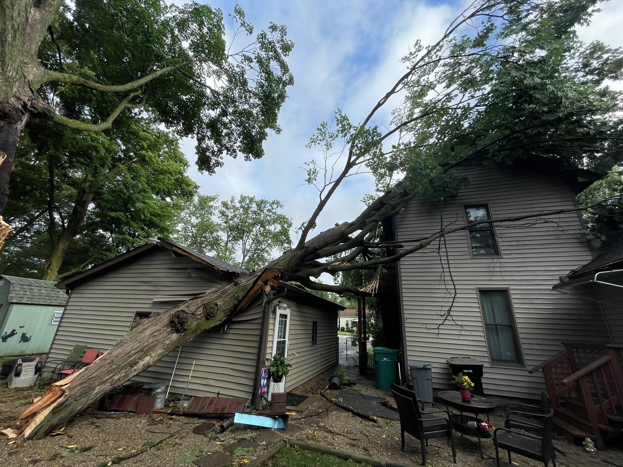
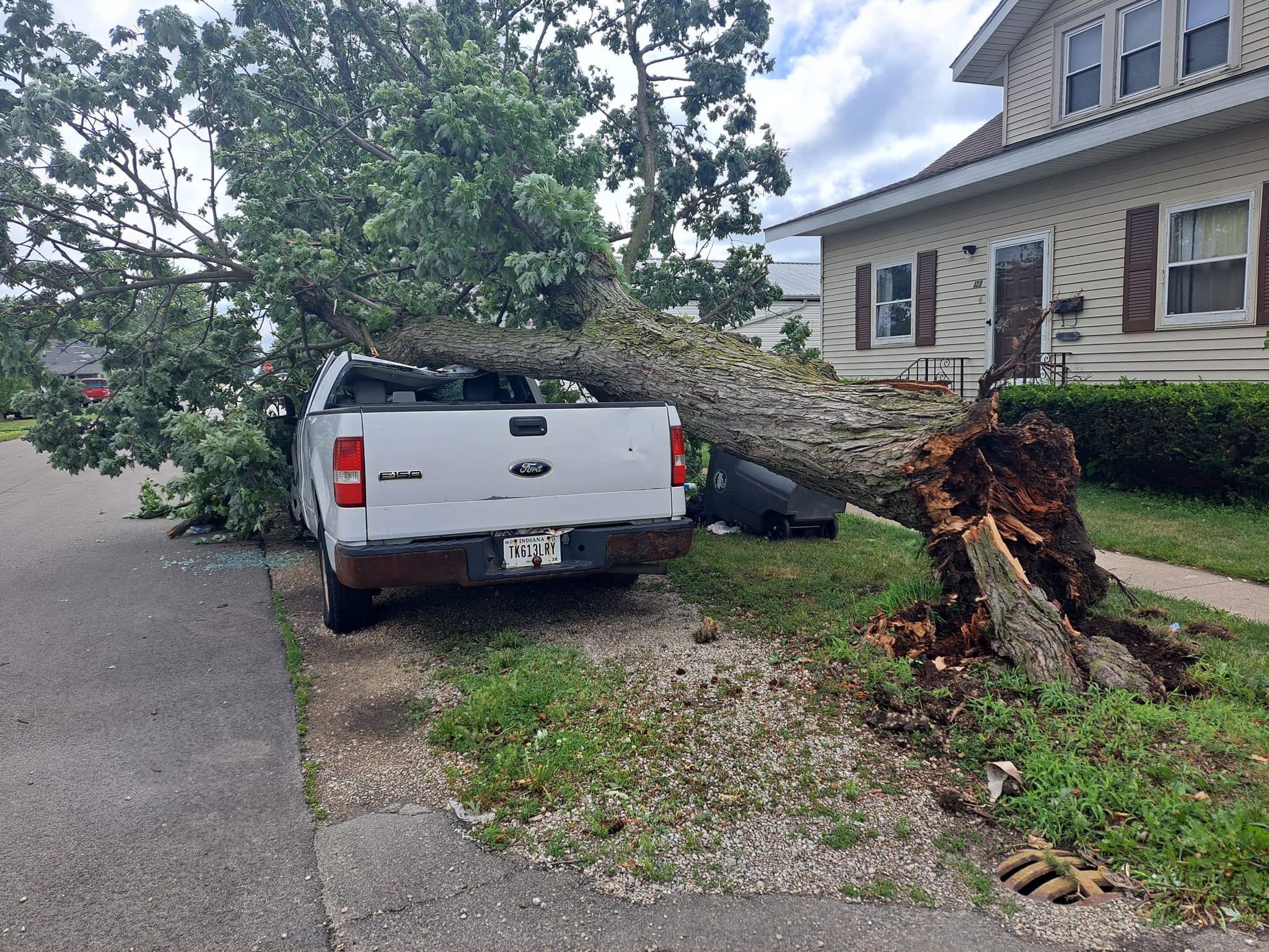
A tree landed on a house in New Carlisle, IN. (Emmett Twomey - ABC57 News) |
Trees down onto a car in Portland, IN (Taylor Williams - ABC21 News) |
Trees down onto a home in Portland, IN (Taylor Williams - ABC21 News) |
 |
 |
.jpg) |
.jpg) |
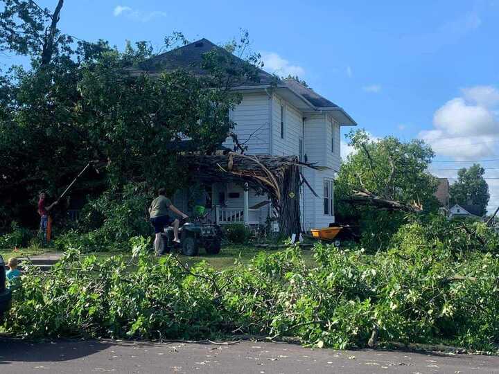
| Large pine trees snapped in Churubusco, IN (Belva Sutton Dreer) |
Pickup smashed in Portland (Jay County EMA) |
Multiple trees down on house east of Portland (Jay County EMA) |
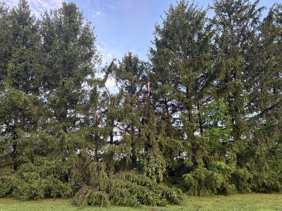
Multiple pine trees demolished northwest of Portland (Jay County EMA) |
 |
 |
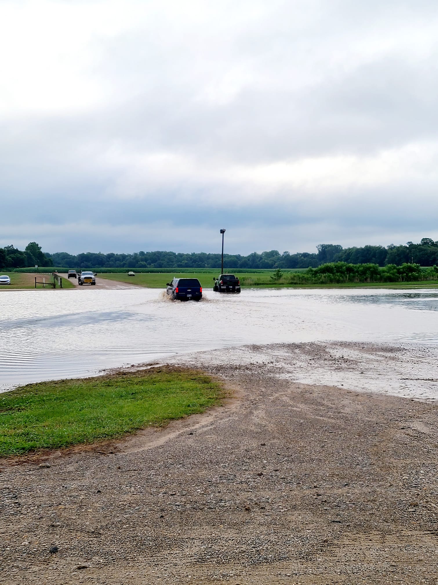
| Flooding at the entrance of the Elkhart County Fair on the morning of July 29th (Sheryl Diane) |
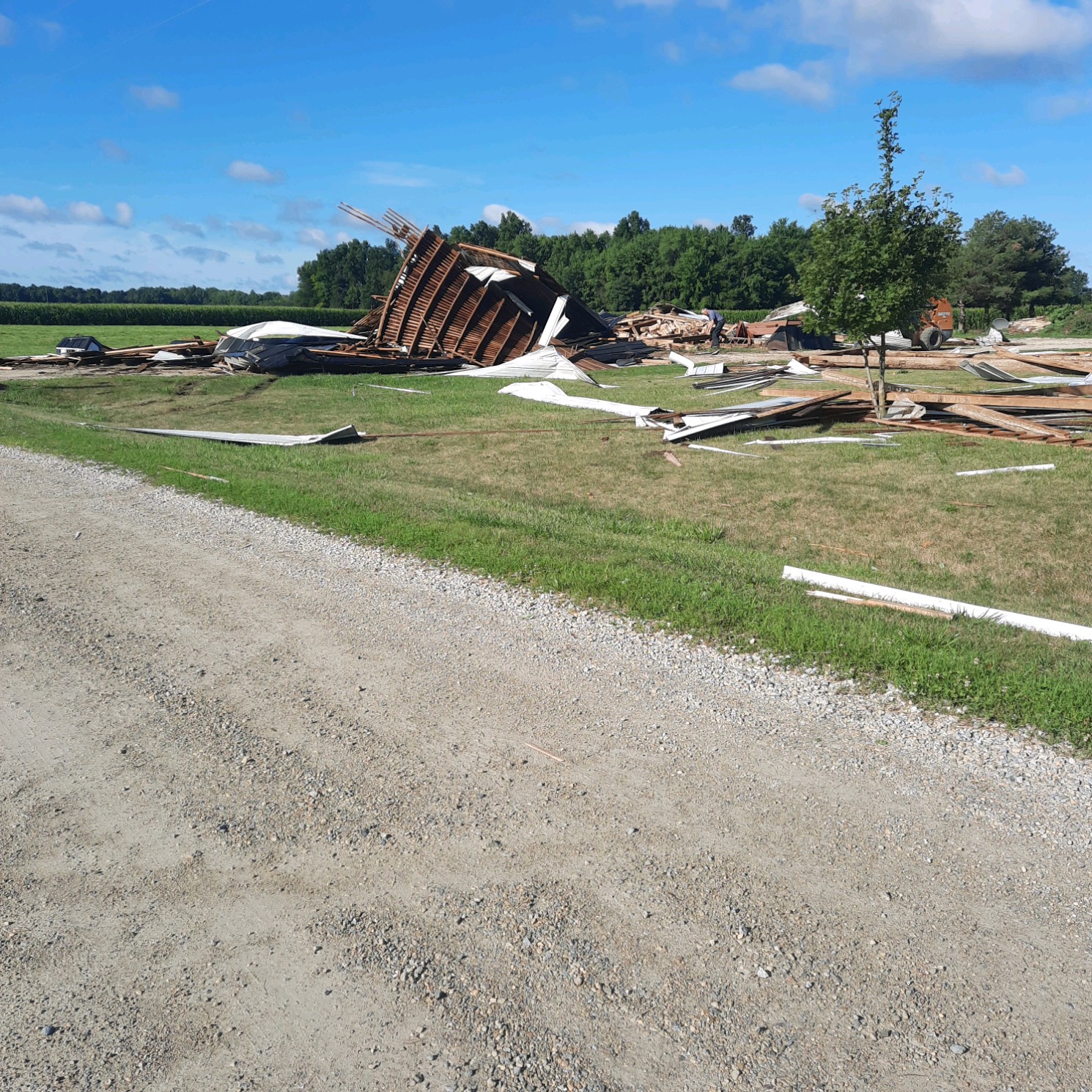
Barn demolished northwest of Salamonia (Jay County EMA) |
 |
 |
 |
 |
| Tornado damage northwest of Hicksville, OH (Paulding County EMA) |
Tornado damage northwest of Hicksville, OH (Paulding County EMA) |
Tornado damage northwest of Hicksville, OH (Paulding County EMA) |
Tornado damage northwest of Hicksville, OH (Paulding County EMA) |
Radar
 |
 |
 |
 |
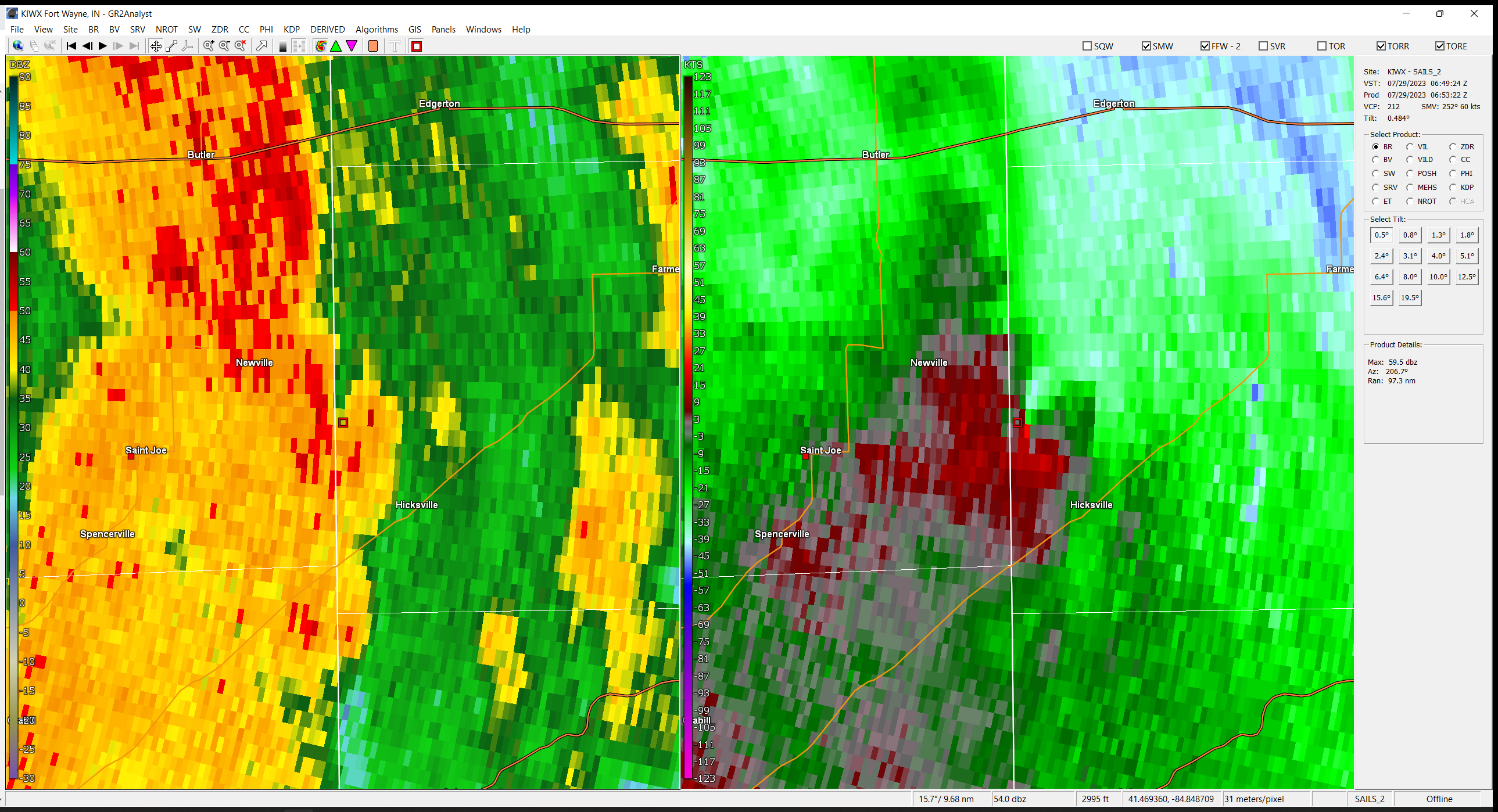
| Radar Loop from 7 PM ET July 28 to 12 AM ET July 29. Round 1 of severe storms. (Courtesy of Iowa Environmental Mesonet) | Radar Loop from 12 AM ET July 29 to 5 AM ET July 29. Round 2 of severe storms. (Courtesy of Iowa Environmental Mesonet) | A reflectivity nub and storm relative velocity capture showing the rotation of an EF-0 QLCS tornado near Hicksville in western Defiance county, Ohio. | KIWX WSR-88D Dual Pol Estimated Storm Total Rainfall |
Storm Reports & Rainfall Totals
979
NWUS53 KIWX 301933
LSRIWX
Preliminary Local Storm Report...Summary
National Weather Service Northern Indiana
333 PM EDT Sun Jul 30 2023
..TIME... ...EVENT... ...CITY LOCATION... ...LAT.LON...
..DATE... ....MAG.... ..COUNTY LOCATION..ST.. ...SOURCE....
..REMARKS..
0617 AM Tstm Wnd Dmg 2 NNW Buchanan 41.86N 86.38W
07/28/2023 Berrien MI Public
Large branches down on Glendora Road, north
of Reed Road.
0943 PM Tstm Wnd Dmg 1 N Van Wert 40.88N 84.58W
07/28/2023 Van Wert OH Trained Spotter
Tree down.
1035 PM Hail 1 NE Kimmel 41.41N 85.53W
07/28/2023 M1.00 inch Noble IN Public
Some melting has occurred in the picture
provided so the size could have been
approaching 1.25 inch diam hail. Time
estimated by radar.
1055 PM Flash Flood 1 WNW Rochester 41.06N 86.21W
07/28/2023 Fulton IN Broadcast Media
Up to 6 inches water flowing across road on
East 9th Street near railroad crossing.
1227 AM Hail Montpelier 41.58N 84.60W
07/29/2023 E1.25 inch Williams OH Public
Photo on Facebook of hail slightly larger
than a quarter.
1230 AM Hail 1 E Montpelier 40.55N 85.26W
07/29/2023 M1.25 inch Blackford IN Public
Photo on Facebook on hail slightly larger
than a quarter.
1233 AM Hail Pioneer 41.68N 84.55W
07/29/2023 M1.00 inch Williams OH Public
Photos on Facebook show several quarter size
hailstones in Pioneer.
1235 AM Tstm Wnd Dmg Waterford 41.67N 86.84W
07/29/2023 La Porte IN Public
Numerous large trees down on West Calloway
Street. Photos on Twitter. Time estimated
via radar.
0118 AM Tstm Wnd Dmg New Carlisle 41.70N 86.51W
07/29/2023 St. Joseph IN Broadcast Media
Numerous trees, tree limbs and power lines
down in New Carslile. Some trees fell onto
homes . No injuries reported. Time estimated
from radar.
0130 AM Tstm Wnd Dmg Lake of the Woods 41.42N 86.24W
07/29/2023 Marshall IN Emergency Mngr
Tree down across road in Lake of the Woods.
Time estimated by radar.
0130 AM Tstm Wnd Dmg Plymouth 41.35N 86.32W
07/29/2023 Marshall IN Emergency Mngr
Tree down along North Michigan Street in
Plymouth. Time estimated from radar.
0142 AM Tstm Wnd Dmg 2 S Mishawaka 41.64N 86.16W
07/29/2023 St. Joseph IN Fire Dept/Rescue
Corrects previous non-tstm wnd dmg report
from 2 S Mishawaka. Tree down blocking
roadway. Time estimated by radar.
0145 AM Tstm Wnd Dmg Simonton Lake 41.75N 85.97W
07/29/2023 Elkhart IN Trained Spotter
3 to 6 inch diameter tree limbs down.
0145 AM Tstm Wnd Dmg North Liberty 41.54N 86.43W
07/29/2023 St. Joseph IN Broadcast Media
Time estimated via radar. Tree down at
Jefferson and IN-4 in North Liberty.
0146 AM Tstm Wnd Dmg North Liberty 41.53N 86.43W
07/29/2023 St. Joseph IN Broadcast Media
Broadcast media reports several trees down
in North Liberty.
0148 AM Tstm Wnd Dmg 2 N Elkhart 41.72N 85.97W
07/29/2023 Elkhart IN Trained Spotter
3 to 6 inch diameter tree limbs down in
northern Elkhart.
0150 AM Tstm Wnd Dmg 1 NE Lake Manitou 41.06N 86.18W
07/29/2023 Fulton IN Public
Trees and tree limb damage reported just
east of Rochester on Twitter.
0155 AM Tstm Wnd Gst 1 ENE Rochester 41.07N 86.18W
07/29/2023 M60 MPH Fulton IN AWOS
Corrects previous report from 1 ENE
Rochester. AWOS station KRCR Rochester.
0155 AM Tstm Wnd Dmg North Liberty 41.53N 86.43W
07/29/2023 St. Joseph IN Emergency Mngr
Report of powerlines down in North Liberty.
0200 AM Flash Flood 1 NE New Buffalo 41.80N 86.73W
07/29/2023 Berrien MI Trained Spotter
Water rushing across the roadway (Bell Road
and US 12).
0205 AM Tstm Wnd Gst 1 SSE James Lake 41.31N 85.72W
07/29/2023 M67 MPH Kosciusko IN NWS Employee
Multiple trees down in subdivision.
0206 AM Tstm Wnd Dmg Mentone 41.17N 86.04W
07/29/2023 Kosciusko IN Amateur Radio
Amatuer radio operator reports tree down in
front of their residence at Maple Street and
Tucker Street. Highest measured gust 47 MPH.
0212 AM Tstm Wnd Dmg 2 SSW Teegarden 41.44N 86.40W
07/29/2023 Marshall IN Broadcast Media
Tree down at Rose and Exit 2b between
Walkerton and La Paz, IN.
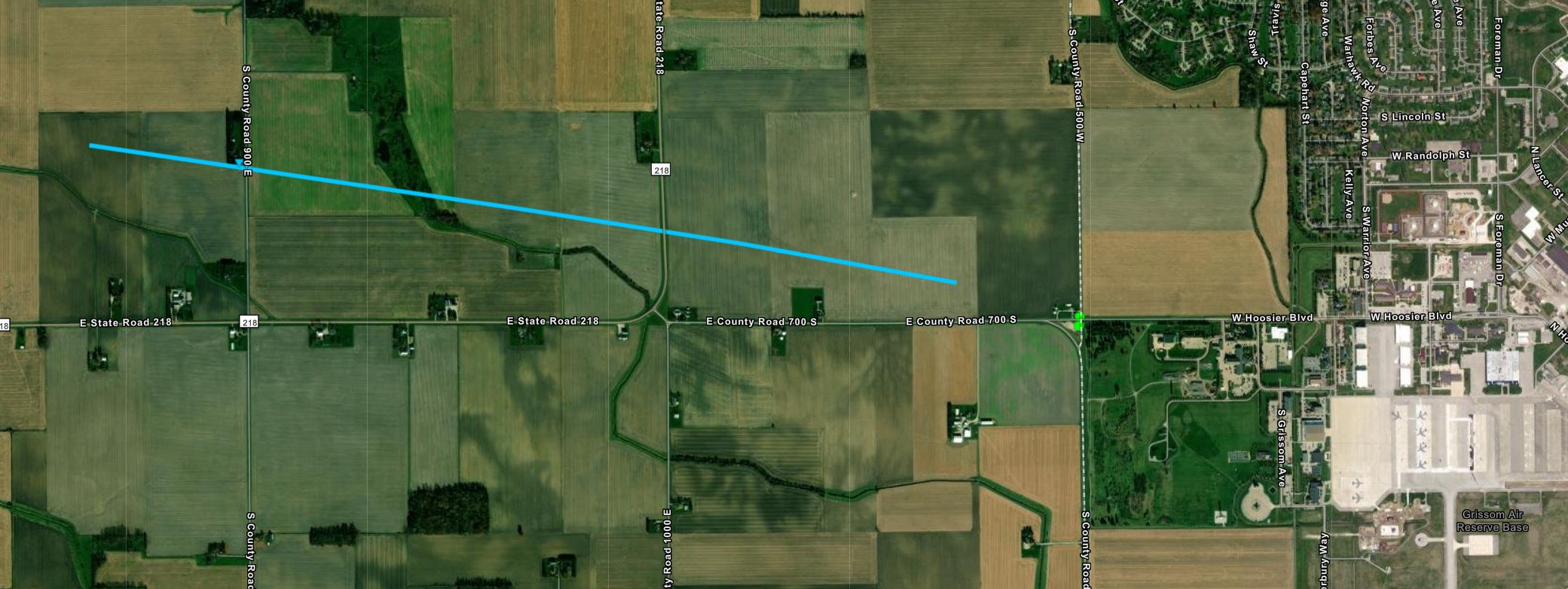
0212 AM Tornado 2 ENE Walton 40.67N 86.21W
07/29/2023 Cass IN NWS Storm Survey
A survey of information provided by a
resident as well as Cass County Emergency
Management revealed a circulation was in
contact with the ground at times between
Walton and the Cass/Miami county line. The
majority of the damage was to beans and corn
extending from west of S CR 900 E and north
of SR 218 to near the intersection of E CR
700 S and S CR 500 W. A small area of tree
damage was found at a property on S CR 900 E
in the path of the crop damage. As a result,
an EF0 tornado has been confirmed with
maximum winds estimated to 75 mph.
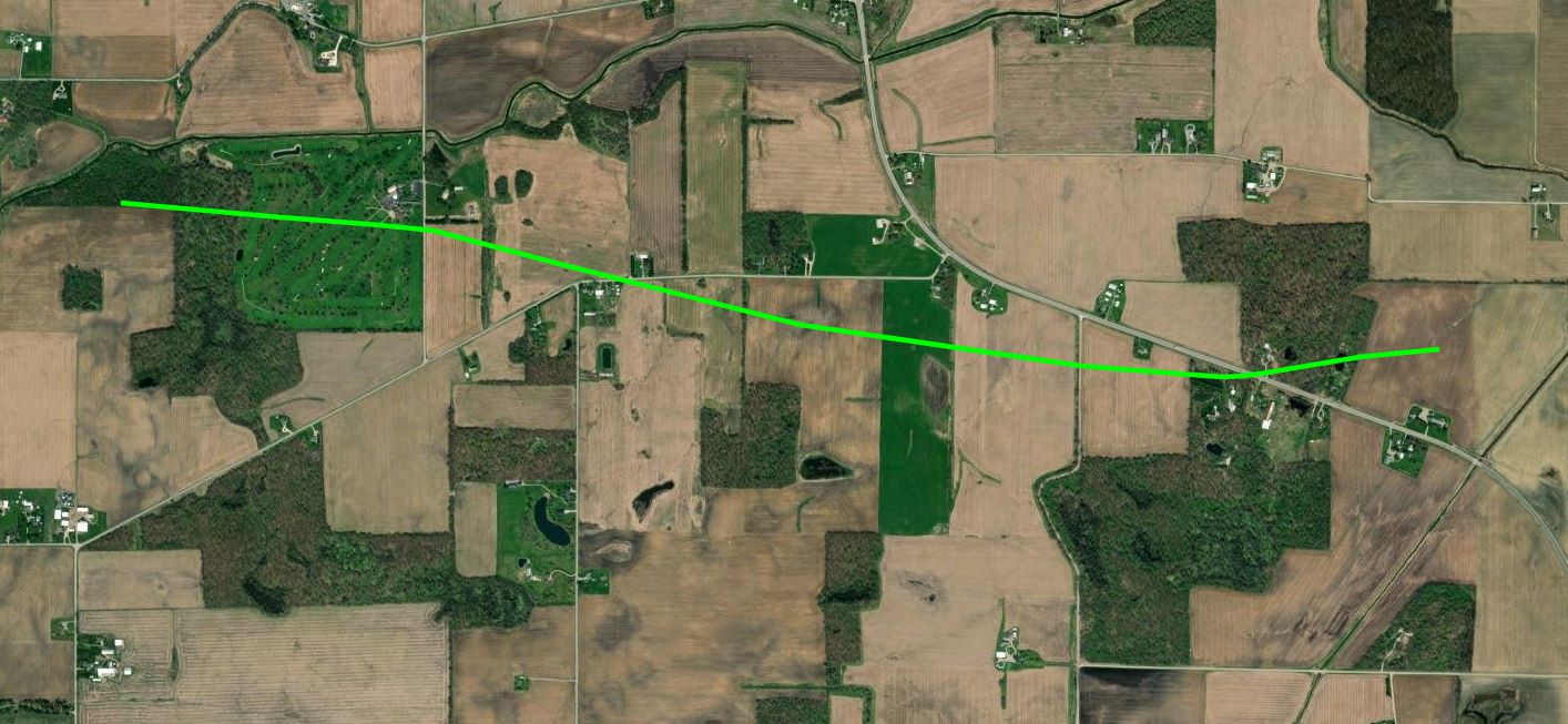
0226 AM Tornado 2 NNW Lake Everett 41.18N 85.32W
07/29/2023 Whitley IN NWS Storm Survey
GROUND AND STORM SPOTTER ASSISTED DRONE
SURVEYS REVEALED A TORNADO TOUCHED DOWN JUST
WEST OF THE EEL RIVER GOLF COURSE SOUTH OF
CHURUBUSCO AND TRACKED RAPIDLY EAST
SOUTHEAST CROSSING US33 BEFORE DISSIPATING
IN A CORN FIELD WEST OF CHASE ROAD. TREES
WERE DAMAGED ON THE GOLF COURSE AND ALONG
COUNTY LINE ROAD WHERE METAL POWER POLES
WERE BENT. THIS TORNADO INTENSIFIED FURTHER
AS IT REACHED THE HILDEBRAND/FRAZIER ROAD
INTERSECTION WITH NUMEROUS TREES FELLED AND
A HOME SUSTAINED MINOR ROOF AND SIDING
DAMAGE. THE TORNADO CONTINUED DOWNSTREAM
THROUGH CROP FIELDS BEFORE HITTING ANOTHER
RESIDENCE NORTH OF US33 WITH NUMEROUS LARGE
TREE LIMBS DOWN, TOPS SHEARED OFF OR SNAPPED
AT GROUND LEVEL HERE EITHER SIDE O. F US33.
THE HOME SUSTAINED DAMAGE FROM FALLEN TREES
AND LIMBS. AS A RESULT AN EF1 TORNADO HAS
BEEN CONFIRMED WITH MAXIMUM WINDS TO 90 MPH.
0236 AM Tstm Wnd Dmg 3 NNE Lake Everett 41.19N 85.29W
07/29/2023 Allen IN Amateur Radio
Powerlines down at US 33 and Carroll Rd.
0236 AM Tstm Wnd Dmg 3 WNW Wallen 41.18N 85.21W
07/29/2023 Allen IN Amateur Radio
Two trees down on Dupont and Fritz Roads.
Time estimated from radar.
0236 AM Tstm Wnd Dmg 3 WNW Wallen 41.18N 85.21W
07/29/2023 Allen IN Public
Trees down at Dupont Rd and Hand Rd. Time
estimated via radar.
0242 AM Tstm Wnd Dmg 1 N Wallen 41.18N 85.17W
07/29/2023 Allen IN Public
Trees down in the parking lot of this store.
0242 AM Tstm Wnd Dmg 1 NNE Wallen 41.18N 85.16W
07/29/2023 Allen IN Public
Tree limbs down and shingles off the roof at
Avalon at Northbrook Apartments & Townhomes.
Time estimated via radar.
0245 AM Tstm Wnd Dmg 3 WNW Wallen 41.18N 85.21W
07/29/2023 Allen IN Public
Many trees down or snapped, tore part of
roof off of barn.
0245 AM Hail 4 NNE Fort Wayne 41.12N 85.10W
07/29/2023 M0.75 inch Allen IN Trained Spotter
0246 AM Tstm Wnd Dmg Saint Joe 41.32N 84.90W
07/29/2023 De Kalb IN Public
Tree limbs down in the Saint Joe area. Time
estimated by radar.
0249 AM Tstm Wnd Dmg 2 NW Woodburn 41.15N 84.88W
07/29/2023 Allen IN Amateur Radio
Siding damage to a shed, plus numerous tree
branches down.
0249 AM Tstm Wnd Dmg 2 NE New Haven 41.09N 84.99W
07/29/2023 Allen IN Trained Spotter
Few trees and power lines down near New
Haven. Estimated wind gusts to 60 mph.
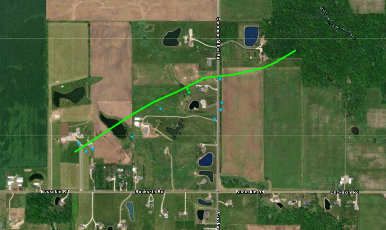
0253 AM Tornado 3 NNW Hicksville 41.33N 84.79W
07/29/2023 Defiance OH NWS Storm Survey
A ground and drone survey revealed a tornado
touched down at a property west of Casebeer
Miller Road and north of Buckskin Road, and
tracked quickly to the northeast, crossing
about a third of a mile north of Buckskin
Road before weakening and dissipating in an
area of trees. Several trees were snapped or
uprooted, with 3 barns suffering minor to
major damage as well as one home suffering
damage to a roof and pool deck. The tornado
is rated as an EF1 with maximum wind speeds
estimated up to 90 mph and a width of
approximately 100 yards.
0300 AM Tstm Wnd Gst 4 N Hicksville 41.35N 84.77W
07/29/2023 M62 MPH Defiance OH Amateur Radio
0300 AM Flash Flood Stevensville 42.02N 86.52W
07/29/2023 Berrien MI Public
Drone footage on Facebook taken on the
morning of July 29th shows flooding in
Hickory Creek Park. Water partially covering
playground equipment and tennis courts.
Unknown how deep the water is. Time of flash
flooding estimated from radar.
0315 AM Tstm Wnd Dmg 4 SE Edgerton 41.41N 84.71W
07/29/2023 Defiance OH County Official
Delayed report. Trees down onto powerlines
on Cicero Road. Road was closed for three
hours due to downed powerlines per Defiance
County Sheriff. Time estimated by radar.
0330 AM Tstm Wnd Dmg Portland 40.43N 84.98W
07/29/2023 Jay IN County Official
Jay County Sheriffs Office reports
powerlines down on roads in Portland. Time
estimated via radar.
0330 AM Tstm Wnd Dmg Portland 40.43N 84.98W
07/29/2023 Jay IN Emergency Mngr
Powerlines down. Time estimated by radar.
0330 AM Tstm Wnd Dmg Salamonia 40.38N 84.86W
07/29/2023 Jay IN Public
Tree down onto unoccupied car. Time
estimated from radar.
0330 AM Tstm Wnd Dmg Salamonia 40.38N 84.87W
07/29/2023 Jay IN Emergency Mngr
5773 E and 400 S in Salamonia.
0330 AM Tstm Wnd Dmg 2 NE Center 40.47N 85.05W
07/29/2023 Jay IN Emergency Mngr
Tree down at 350 W and 200 N Portland.
0330 AM Tstm Wnd Dmg Portland 40.43N 84.98W
07/29/2023 Jay IN Emergency Mngr
Multiple trees down. Time estimated by
radar.
0330 AM Tstm Wnd Dmg Salamonia 40.38N 84.86W
07/29/2023 Jay IN Emergency Mngr
Tree down 6009 E and 400 S in Salamonia.
0331 AM Tstm Wnd Dmg 1 ESE Portland 40.43N 84.96W
07/29/2023 Jay IN County Official
Jay County Sheriffs Office reports that 100
S is closed between 100 E and 300 E due to
power lines down across the road. Time
estimated via radar.
0348 AM Tstm Wnd Dmg Lima 40.74N 84.11W
07/29/2023 Allen OH Public
Report from mPING: 3-inch tree limbs broken.
Time estimated from radar.
0700 AM Rain 1 E Waterford 41.67N 86.83W
07/29/2023 M3.98 inch La Porte IN Cocorahs
Rain total rom 12 AM to 7 AM CDT.
0825 AM Rain Saint Joseph 42.10N 86.49W
07/29/2023 M5.14 inch Berrien MI Public
0845 AM Flood Elkhart 41.69N 85.97W
07/29/2023 Elkhart IN Broadcast Media
Delayed report. Flooding at the Elkhart
County Fair near Gate 1. Unsure how deep the
water is. Photo on Facebook.
0945 AM Rain Niles 41.84N 86.25W
07/29/2023 M4.91 inch Berrien MI Public
Rain total since midnight.
1023 AM Rain 1 W Delong 41.14N 86.43W
07/29/2023 E6.00 inch Fulton IN Public
1030 AM Rain 3 ESE Simonton Lake 41.74N 85.91W
07/29/2023 M6.25 inch Elkhart IN Public
48 hour rainfall total.
&&
$$
053 NOUS43 KIWX 291545 PNSIWX INZ005>009-012>015-017-018-020-022>027-032>034-103-104-116-203-204-216-MIZ078>081- 177-277-OHZ001-002-004-005-015-016-024-025-300345- Public Information Statement National Weather Service Northern Indiana 1145 AM EDT Sat Jul 29 2023 ...24 HOUR PRECIPITATION REPORTS THROUGH 10 AM EDT JULY 29, 2023... Location Amount Time/Date Provider ...Indiana... ...Adams County... 0.8 N Linn Grove 0.98 in 1045 AM 07/29 HADS ...Allen County... Hoagland 1.5 SSW 1.39 in 0630 AM 07/29 COCORAHS SPENCERVILLE 1.25 in 0500 AM 07/29 CWOP Ellisville 0.3 W 1.22 in 0730 AM 07/29 COCORAHS Harlan 3.4 NE 1.09 in 0700 AM 07/29 COCORAHS Fort Wayne 9.3 W 1.07 in 0700 AM 07/29 COCORAHS Fort Wayne 7.1 WSW 1.03 in 0800 AM 07/29 COCORAHS Fort Wayne 1.6 S 1.03 in 0800 AM 07/29 COCORAHS Fort Wayne 2.6 NE 1.02 in 0700 AM 07/29 COCORAHS New Haven 4.4 NE 1.02 in 0700 AM 07/29 COCORAHS Monroeville 0.2 ESE 0.92 in 0700 AM 07/29 COCORAHS Woodburn 2.8 WSW 0.92 in 0700 AM 07/29 COCORAHS Fort Wayne 1.9 S 0.92 in 0800 AM 07/29 COCORAHS Fort Wayne 8.0 NE 0.90 in 0930 AM 07/29 COCORAHS 2 E Wallen 0.88 in 0651 AM 07/29 Fort Wayne 9.1 SE 0.88 in 0700 AM 07/29 COCORAHS Fort Wayne 6.0 N 0.87 in 0700 AM 07/29 COCORAHS Harlan 2.2 ENE 0.83 in 0700 AM 07/29 COCORAHS Fort Wayne 10.4 N 0.81 in 0700 AM 07/29 COCORAHS Woodburn 2.6 NNW 0.79 in 0900 AM 07/29 COCORAHS Fort Wayne 4.1 NE 0.76 in 0700 AM 07/29 COCORAHS Fort Wayne 2.6 NW 0.75 in 0700 AM 07/29 COCORAHS Fort Wayne International Ap 0.74 in 1054 AM 07/29 ASOS SPENCERVILLE 0.73 in 1130 AM 07/29 CWOP Fort Wayne International Ap 0.72 in 0454 AM 07/29 ASOS ...Blackford County... Hartford City 0.2 NNW (WB9HL 1.00 in 0800 AM 07/29 COCORAHS Hartford City 4 ESE 0.70 in 0800 AM 07/29 COOP ...Cass County... Walton 1.66 in 0445 AM 07/29 CWOP Galveston 1.12 in 0500 AM 07/29 CWOP Young America 1.03 in 0800 AM 07/29 COOP Galveston 0.82 in 1115 AM 07/29 CWOP Walton 0.59 in 1130 AM 07/29 CWOP ...De Kalb County... Hamilton 3.0 ESE 2.40 in 0700 AM 07/29 COCORAHS Ashley 1.80 in 0900 AM 07/29 COOP 1.7 SE Butler 1.19 in 0700 AM 07/29 COOP 0.6 S Garrett 1.15 in 0700 AM 07/29 COOP Auburn 0.4 NNW 1.07 in 0700 AM 07/29 COCORAHS Auburn 0.2 SE 0.18 in 0800 PM 07/28 COCORAHS Garrett 0.16 in 0235 AM 07/29 CWOP ...Elkhart County... Jamestown 3.25 in 0458 AM 07/29 CWOP Elkhart 4.8 SW 3.25 in 0600 AM 07/29 COCORAHS Jamestown 3.02 in 1130 AM 07/29 CWOP Goshen 3.5 NNW 2.99 in 0622 AM 07/29 COCORAHS Goshen 4.6 N 2.87 in 0700 AM 07/29 COCORAHS Goshen 2.8 NNE 2.66 in 0700 AM 07/29 COCORAHS Elkhart 3.0 SSE 2.66 in 0830 AM 07/29 COCORAHS Wakarusa 2.4 NNE 2.58 in 0700 AM 07/29 COCORAHS Goshen 6.8 NE 2.56 in 0700 AM 07/29 COCORAHS Elkhart Municipa 2.15 in 0455 AM 07/29 AWOS Goshen 0.3 NE 2.05 in 0700 AM 07/29 COCORAHS Goshen 1.8 SE 1.90 in 0700 AM 07/29 COCORAHS Goshen 1.4 SSE 1.90 in 0700 AM 07/29 COCORAHS Goshen 1.67 in 0453 AM 07/29 ASOS Goshen 1.67 in 0553 AM 07/29 ASOS Syracuse 4.4 NNW 1.58 in 0700 AM 07/29 COCORAHS Goshen 3.0 WSW 1.49 in 0700 AM 07/29 COCORAHS Elkhart Municipa 1.38 in 1135 AM 07/29 AWOS Goshen 2.3 WNW 1.29 in 0700 AM 07/29 COCORAHS Ligonier 4.3 WNW 1.00 in 0800 AM 07/29 COCORAHS Goshen 3 SW 0.14 in 0700 PM 07/28 COOP ...Fulton County... Rochester 3.25 in 0700 AM 07/29 COOP Rochester 2.4 NW 2.56 in 0600 AM 07/29 COCORAHS Akron 1.90 in 0834 AM 07/29 COCORAHS Kewanna 4.9 S 1.10 in 0700 AM 07/29 COCORAHS ...Grant County... 2.2 N Marion 1.17 in 0700 AM 07/29 COOP (KC9QCJ) Shamrock Lakes 3.0 1.16 in 0700 AM 07/29 COCORAHS Upland 2.4 SSE 0.70 in 0700 AM 07/29 COCORAHS Grant County Municipal Apt 0.64 in 0455 AM 07/29 AWOS Grant County Municipal Apt 0.43 in 1115 AM 07/29 AWOS ...Huntington County... 2.4 NW Warren 0.95 in 1045 AM 07/29 HADS Huntington 0.80 in 0458 AM 07/29 CWOP 2.4 NW Warren 0.77 in 0445 AM 07/29 HADS Huntington 0.73 in 1128 AM 07/29 CWOP Huntington 0.3 W 0.72 in 0700 AM 07/29 COCORAHS Huntington 0.05 in 0135 AM 07/29 AWOS 1.7 E Bowerstown 0.05 in 0400 AM 07/29 HADS 1.7 E Bowerstown 0.05 in 1100 AM 07/29 HADS ...Kosciusko County... Cromwell 2.9 W 1.96 in 0700 AM 07/29 COCORAHS Leesburg 6.7 ESE 1.81 in 0700 AM 07/29 COCORAHS Leesburg 0.1 WNW 1.66 in 0600 AM 07/29 COCORAHS Warsaw 1.2 NNE 1.59 in 0700 AM 07/29 COCORAHS 2.3 N North Webster 1.44 in 0800 AM 07/29 COOP Claypool 1.2 E 1.43 in 0710 AM 07/29 COCORAHS Warsaw 5.3 WNW 1.43 in 0846 AM 07/29 COCORAHS Warsaw 3.0 SE 1.42 in 0800 AM 07/29 COCORAHS North Webster 2.3 N 1.42 in 0800 AM 07/29 COCORAHS Warsaw 1.4 N 1.40 in 0800 AM 07/29 COCORAHS Milford 2.7 SSW 1.33 in 0600 AM 07/29 COCORAHS 2 NW Tippecanoe Lake 1.32 in 0620 AM 07/29 NWS Employee Warsaw 3.7 E 1.32 in 0730 AM 07/29 COCORAHS Milford 0.9 N 1.28 in 0700 AM 07/29 COCORAHS Warsaw Muni 1.15 in 0455 AM 07/29 AWOS Syracuse 3.0 ESE 1.04 in 0800 AM 07/29 COCORAHS Warsaw Muni 1.01 in 1115 AM 07/29 AWOS 1 SW Sevastopol 0.90 in 0131 AM 07/29 AWS ...La Porte County... 1 SE Hudson Lake 4.10 in 0115 AM 07/29 Public Mill Creek 1.9 NNE 3.71 in 0655 AM 07/29 COCORAHS Trail Creek 3.0 SE 3.49 in 0800 AM 07/29 COCORAHS New Carlisle 3.0 WNW 2.65 in 0900 AM 07/29 COCORAHS La Porte 2.3 ESE 2.43 in 0930 AM 07/29 COCORAHS Michigan City 5.4 S 2.13 in 0800 AM 07/29 COCORAHS La Porte 1.6 SW 1.79 in 0800 AM 07/29 COCORAHS Wanatah 4.4 ESE 1.72 in 0900 AM 07/29 COCORAHS La Porte 6.8 SW 1.62 in 0800 AM 07/29 COCORAHS 0.8 W La Porte 1.22 in 1258 AM 07/29 COOP La Crosse 3.2 NW 1.20 in 0800 AM 07/29 COCORAHS La Crosse 1.2 W 0.72 in 0800 AM 07/29 COCORAHS La Porte 0.17 in 0455 AM 07/29 AWOS La Porte 0.07 in 1115 AM 07/29 AWOS ...Lagrange County... Lagrange 4.6 ESE 1.82 in 0835 AM 07/29 COCORAHS LaGrange 1.3 ENE 1.47 in 0645 AM 07/29 COCORAHS Lagrange 9.6 ESE 1.42 in 0700 AM 07/29 COCORAHS Wolcottville 1.1 WNW 1.13 in 0808 AM 07/29 COCORAHS ...Marshall County... Burr Oak 4.00 in 0900 AM 07/29 Emergency Mngr Tippecanoe 0.8 S 2.32 in 0700 AM 07/29 COCORAHS Plymouth 2.5 WSW 1.56 in 0700 AM 07/29 COCORAHS Bremen 3.9 WSW 1.23 in 0900 AM 07/29 COCORAHS ...Miami County... 1 N Denver 4.50 in 0640 AM 07/29 Public Macy 2.7 SSE 4.19 in 0700 AM 07/29 COCORAHS Denver 1.3 NE 3.52 in 0700 AM 07/29 COCORAHS Denver 0.5 SSE 2.81 in 0700 AM 07/29 COCORAHS Grissom AFB Peru 1.52 in 0455 AM 07/29 AWOS 0.8 NW Peru 1.44 in 0700 AM 07/29 COOP Peru 4.6 SSE 1.37 in 0600 AM 07/29 COCORAHS Amboy 1.21 in 0500 AM 07/29 CWOP Macy 3.6 SSE 1.16 in 0800 AM 07/29 COCORAHS Peru 0.82 in 0430 AM 07/29 HADS Peru 0.82 in 1130 AM 07/29 HADS Amboy 0.43 in 1115 AM 07/29 CWOP Grissom AFB Peru 0.04 in 1000 AM 07/29 AWOS ...Noble County... Kendallville 2.2 SW 2.12 in 0800 AM 07/29 COCORAHS Kendallville 3.2 N 1.61 in 0700 AM 07/29 COCORAHS Albion 2.8 ENE 1.31 in 0830 AM 07/29 COCORAHS Albion 3.7 S 1.13 in 0930 AM 07/29 COCORAHS Kendallville 4.5 NW 0.92 in 0700 AM 07/29 COCORAHS Kendallville 0.78 in 0235 AM 07/29 AWOS Kendallville 0.63 in 1115 AM 07/29 AWOS Cosperville 0.10 in 1130 AM 07/29 HADS Cosperville 0.02 in 0430 AM 07/29 HADS ...Pulaski County... Monterey 2.2 WNW 3.76 in 0800 AM 07/29 COCORAHS 1.3 SW Ora 1.44 in 1045 AM 07/29 COOP 1.3 SW Ora 1.43 in 0445 AM 07/29 COOP Winamac 9.9 NW 1.37 in 0800 AM 07/29 COCORAHS Francesville 0.80 in 0800 AM 07/29 COOP ...St. Joseph County... New Carlisle 5.20 in 0327 AM 07/29 Public New Carlisle 5.12 in 0757 AM 07/29 COOP South Bend International Ap 3.47 in 0501 AM 07/29 ASOS Granger 1.8 ENE 3.20 in 0700 AM 07/29 COCORAHS South Bend 4.0 SSW 3.05 in 0800 AM 07/29 COCORAHS South Bend 3.3 SE 3.03 in 0800 AM 07/29 COCORAHS 4 ENE Woodland 2.89 in 0240 AM 07/29 Public South Bend 4.6 SSE 2.74 in 0846 AM 07/29 COCORAHS South Bend International Ap 2.73 in 1054 AM 07/29 ASOS 0.9 W Roseland 2.65 in 0415 AM 07/29 COOP Mishawaka 3.9 ENE 2.63 in 0700 AM 07/29 COCORAHS South Bend 4.6 SE 2.43 in 0700 AM 07/29 COCORAHS 0.9 W Roseland 2.43 in 1115 AM 07/29 COOP Lakeville 1.5 SSW 2.20 in 0700 AM 07/29 COCORAHS 1 S Roseland 2.14 in 0251 AM 07/29 Broadcast Media Mishawaka 2.0 E 1.83 in 0700 AM 07/29 COCORAHS South Bend 1.47 in 1230 AM 07/29 Trained Spotter ...Starke County... Winona 2.21 in 0800 AM 07/29 COCORAHS Walkerton 4.4 SSW 1.62 in 0900 AM 07/29 COCORAHS 3.5 N Brems 1.57 in 0500 AM 07/29 HADS 3.5 N Brems 1.44 in 1100 AM 07/29 HADS ...Steuben County... Hamilton 1.7 E 2.74 in 0700 AM 07/29 COCORAHS Angola 1.2 S 1.81 in 0600 AM 07/29 COCORAHS 0.7 E Hamilton 1.75 in 1045 AM 07/29 HADS Angola 8.7 ESE 1.65 in 0700 AM 07/29 COCORAHS 0.7 E Hamilton 1.45 in 0445 AM 07/29 HADS ANGOLA 1.45 in 0455 AM 07/29 CWOP ANGOLA 1.39 in 1125 AM 07/29 CWOP Hudson 4.6 N 1.37 in 0715 AM 07/29 COCORAHS Angola 8.8 ESE 1.35 in 0800 AM 07/29 COCORAHS Hudson 0.3 SE 1.35 in 0856 AM 07/29 COCORAHS Hudson 4.1 NNW 1.33 in 0700 AM 07/29 COCORAHS Angola 4.1 N 1.23 in 0545 AM 07/29 COCORAHS Angola 6.2 NW 1.09 in 0700 AM 07/29 COCORAHS Pigeon Creek 0.59 in 1115 AM 07/29 HADS Pigeon Creek 0.27 in 0415 AM 07/29 HADS ...Wabash County... Wabash 1.5 SW 2.15 in 0700 AM 07/29 COCORAHS La Fontaine 1.1 NW 1.82 in 0600 AM 07/29 COCORAHS 0.7 SE Wabash 1.62 in 0430 AM 07/29 HADS La Fontaine 0.3 SE 1.55 in 0700 AM 07/29 COCORAHS 0.7 SE Wabash 1.19 in 1030 AM 07/29 HADS ...Wells County... Bluffton 1.44 in 0445 AM 07/29 HADS Bluffton 1.37 in 1045 AM 07/29 HADS Craigville 2.7 NW 1.07 in 0800 AM 07/29 COCORAHS Bluffton 0.9 SE 1.02 in 0700 AM 07/29 COCORAHS Bluffton 3.6 N 0.70 in 0700 AM 07/29 COCORAHS Ossian 2.4 W 0.63 in 0800 AM 07/29 COCORAHS ...White County... Monticello 5.5 NNW 1.03 in 0700 AM 07/29 COCORAHS Norway 0.99 in 0445 AM 07/29 HADS Burnettsville 9.9 NNW 0.99 in 1050 AM 07/29 COCORAHS Monticello 0.9 E 0.89 in 0700 AM 07/29 COCORAHS Norway 0.85 in 1045 AM 07/29 HADS 5.6 N Badger Grove 0.65 in 0700 AM 07/29 COOP Idaville 0.2 SW 0.64 in 0700 AM 07/29 COCORAHS Brookston 0.3 SE 0.49 in 0700 AM 07/29 COCORAHS Monticello - White County Ar 0.20 in 0255 AM 07/29 AWOS ...Whitley County... Columbia City 0.5 WSW 1.59 in 0731 AM 07/29 COCORAHS Columbia City 0.2 NE 1.36 in 0800 AM 07/29 COCORAHS Columbia City 6.8 NNE 1.34 in 0700 AM 07/29 COCORAHS Tri-Lakes 3.0 N 1.31 in 0700 AM 07/29 COCORAHS Columbia City 7.4 N 1.21 in 0645 AM 07/29 COCORAHS Columbia City 5.4 N 1.09 in 0700 AM 07/29 COCORAHS Columbia City 4.6 S 0.97 in 0600 AM 07/29 COCORAHS ...Michigan... ...Berrien County... 2 W Sodus 5.95 in 0805 AM 07/29 Public Stevensville 1.7 SSE 5.49 in 0700 AM 07/29 COCORAHS Stevensville 4.50 in 0400 AM 07/29 Public Niles 4.10 in 0500 AM 07/29 CWOP Niles 2.7 W 3.41 in 0800 AM 07/29 COCORAHS Shoreham 2.0 SE 3.41 in 0800 AM 07/29 COCORAHS Niles 3.18 in 1128 AM 07/29 CWOP 3.7 S Watervliet 3.06 in 0400 AM 07/29 UCOOP St. Joseph 2.8 SSE 2.97 in 0700 AM 07/29 COCORAHS 3.7 S Watervliet 2.52 in 1100 AM 07/29 UCOOP Benton Harbor 2.38 in 0453 AM 07/29 ASOS Benton Harbor 2.18 in 1053 AM 07/29 ASOS St. Joseph 1.5 SSE 1.96 in 0700 AM 07/29 COCORAHS Bertrand 1.86 in 0800 AM 07/29 COCORAHS 3 ESE Berrien Springs 1.35 in 0252 PM 07/28 ...Cass County... Niles 3.5 E 2.77 in 0900 AM 07/29 COCORAHS Cassopolis 9.0 SSE 2.04 in 0700 AM 07/29 COCORAHS ...Hillsdale County... Litchfield 0.3 ENE 1.21 in 0719 AM 07/29 COCORAHS Osseo 2.7 NE 0.99 in 0830 AM 07/29 COCORAHS Jonesville 0.2 WSW 0.96 in 0622 AM 07/29 COCORAHS Jonesville 5.9 ENE 0.78 in 0800 AM 07/29 COCORAHS Hillsdale 0.67 in 0455 AM 07/29 AWOS Hillsdale 0.66 in 1115 AM 07/29 AWOS ...St. Joseph County... 2 E Mottville 2.45 in 0927 AM 07/29 Three Rivers 2.4 NE 1.89 in 0700 AM 07/29 COCORAHS Constantine 1.9 E 1.88 in 0700 AM 07/29 COCORAHS 2.0 SE Mendon 1.57 in 0400 AM 07/29 UCOOP 2.0 SE Mendon 1.49 in 1100 AM 07/29 UCOOP 3 ESE Fawn River 1.35 in 0700 AM 07/29 Sturgis Kirsch 1.29 in 0455 AM 07/29 AWOS Sturgis Kirsch 1.05 in 1135 AM 07/29 AWOS ...Ohio... ...Allen County... Elida 1.4 WNW 0.87 in 0935 AM 07/29 COCORAHS Delphos 2.3 ESE 0.77 in 0600 AM 07/29 COCORAHS Bluffton 0.67 in 0500 AM 07/29 CWOP Bluffton 0.65 in 1130 AM 07/29 CWOP Lima 2.7 NE 0.62 in 0700 AM 07/29 COCORAHS Lima 3.0 SSE 0.57 in 0600 AM 07/29 COCORAHS Lima 1 N 0.52 in 1125 AM 07/29 CWOP Spencerville 0.3 SSE 0.51 in 0800 AM 07/29 COCORAHS Lima 1 N 0.48 in 0457 AM 07/29 CWOP Lima 7.3 SE 0.33 in 0700 AM 07/29 COCORAHS Lima 0.02 in 0353 AM 07/29 ASOS ...Defiance County... Defiance 0.77 in 0453 AM 07/29 ASOS Defiance 0.77 in 1053 AM 07/29 ASOS ...Fulton County... Swanton 4.0 S 1.85 in 0632 AM 07/29 COCORAHS Fayette 4.3 ESE 1.56 in 0700 AM 07/29 COCORAHS Archbold 4.7 NW 1.18 in 0645 AM 07/29 COCORAHS 4.6 SW Morenci (R2) (R2) 0.95 in 0500 AM 07/29 COOP 4.6 SW Morenci (R2) (R2) 0.94 in 1100 AM 07/29 COOP 4.6 SW Morenci (R2) (R2) 0.13 in 1000 AM 07/29 COOP ...Henry County... Napoleon 1.2 SSE 1.10 in 0700 AM 07/29 COCORAHS Napoleon 1 SW 1.08 in 0800 AM 07/29 COOP Napoleon 0.6 WSW 1.04 in 0800 AM 07/29 COCORAHS Napoleon 4.5 NNW 1.00 in 0700 AM 07/29 COCORAHS Liberty Center 0.3 NE 0.93 in 0700 AM 07/29 COCORAHS ...Paulding County... Paulding 1.4 NNE 0.81 in 0700 AM 07/29 COCORAHS ...Putnam County... Vaughnsville 0.77 in 1130 AM 07/29 CWOP Vaughnsville 0.73 in 0500 AM 07/29 CWOP Ottawa 1.0 N 0.66 in 0700 AM 07/29 COCORAHS Leipsic 5.4 W 0.50 in 0700 AM 07/29 COCORAHS Ottawa 2.3 SE 0.47 in 0700 AM 07/29 COCORAHS ...Van Wert County... Van Wert 0.84 in 0500 AM 07/29 CWOP Van Wert 0.84 in 1130 AM 07/29 CWOP Van Wert County 0.48 in 1115 AM 07/29 AWOS Van Wert 0.36 in 0100 AM 07/29 CWOP ...Williams County... 1.2 E Bryan 1.75 in 0800 AM 07/29 COOP Pioneer 2.3 S 1.64 in 0700 AM 07/29 COCORAHS Alvordton 0.5 E 1.44 in 0700 AM 07/29 COCORAHS Bryan 2.1 NW 1.07 in 0630 AM 07/29 COCORAHS
Environment
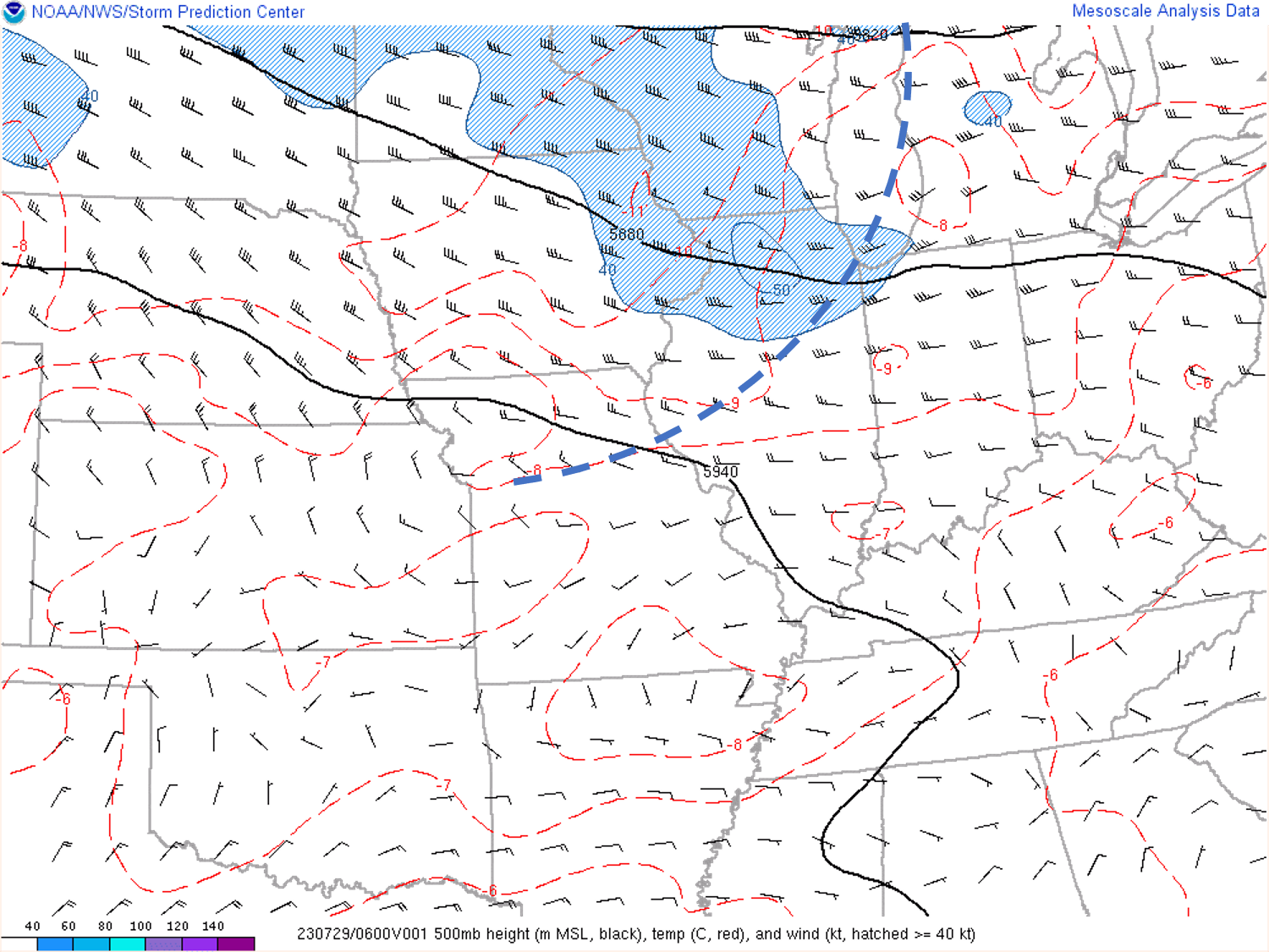
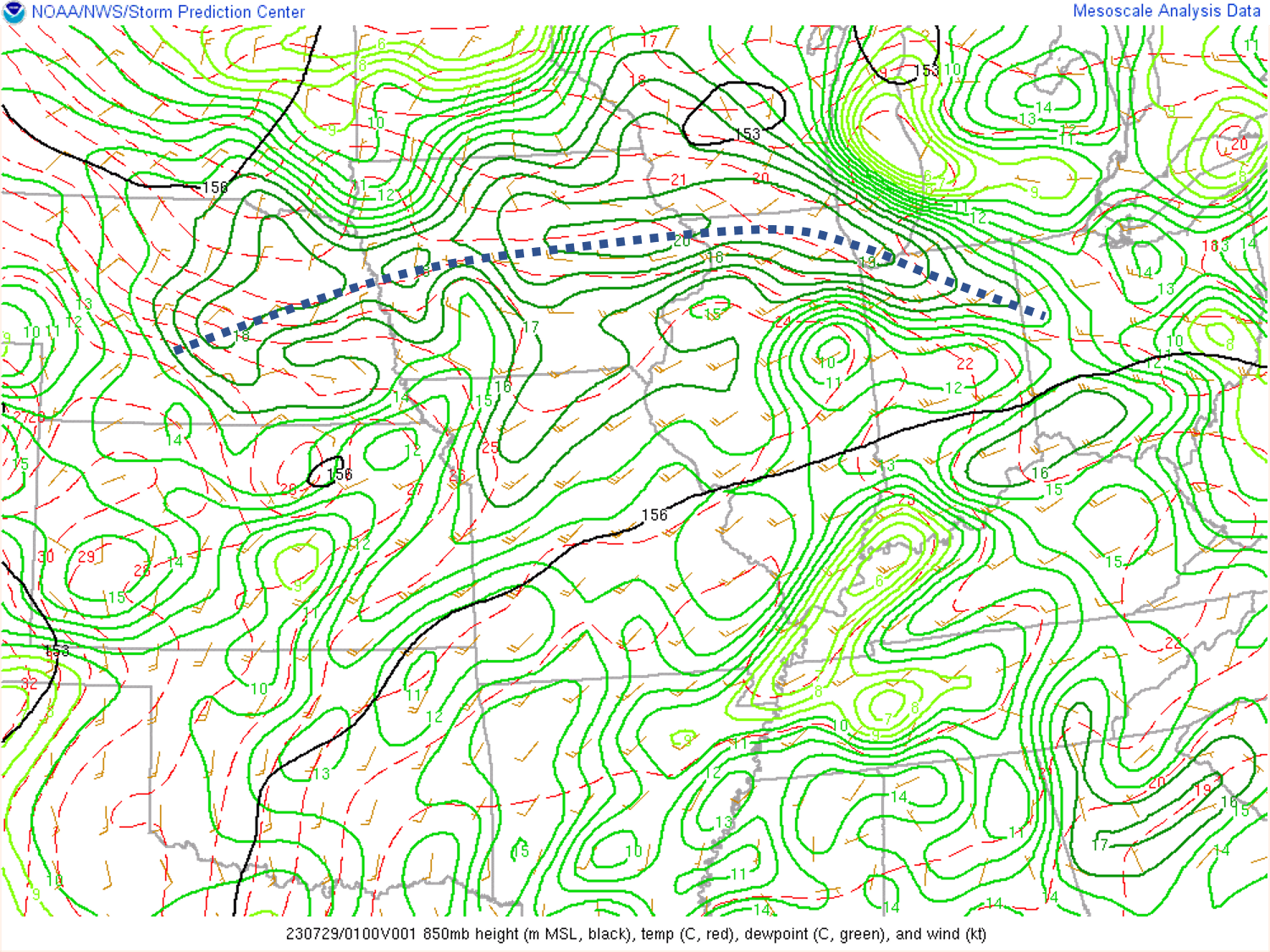
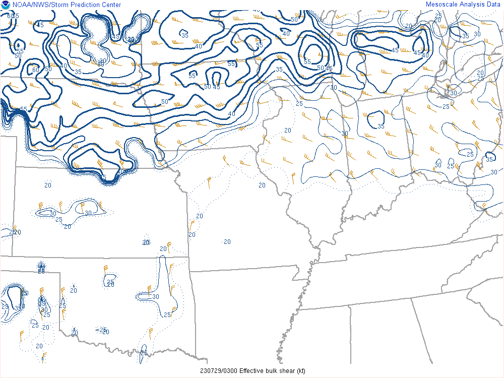
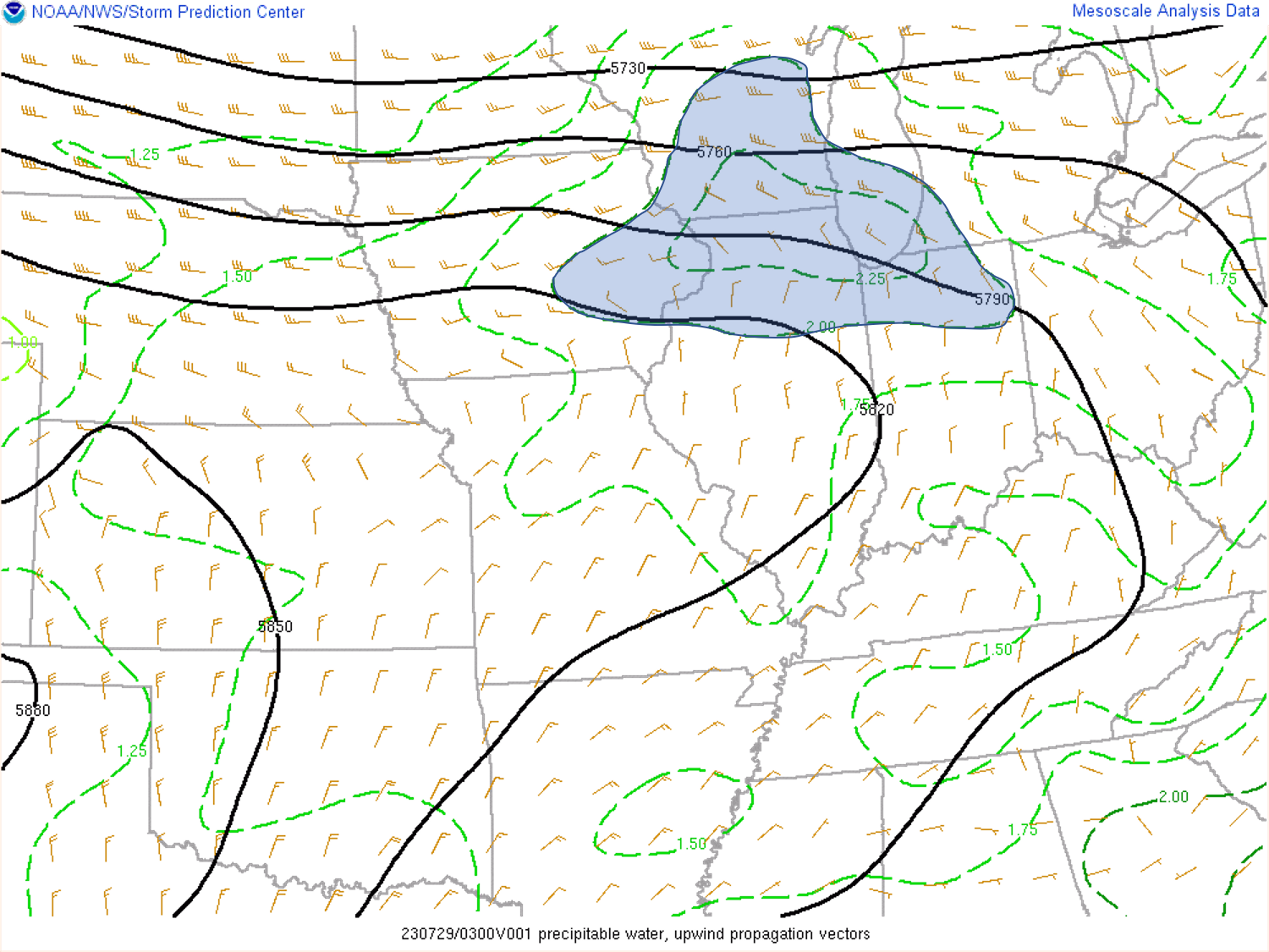
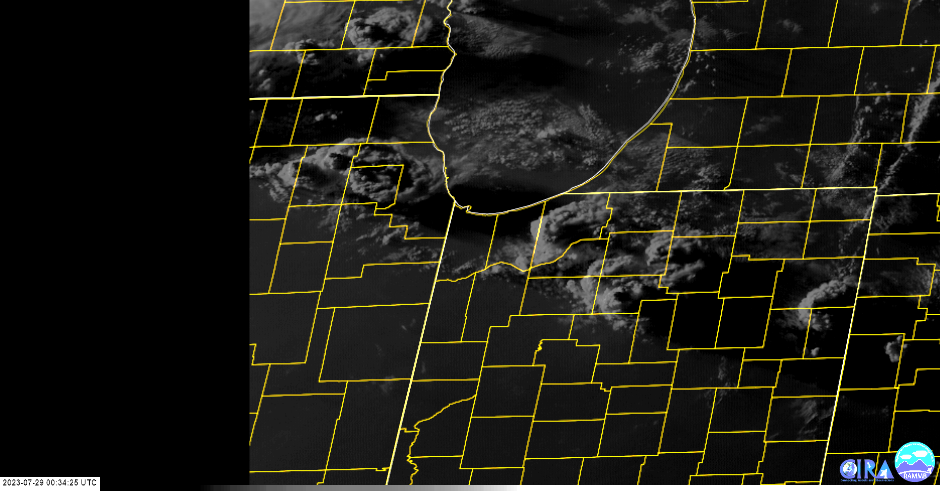
A potent shortwave disturbance (Fig. 1) over ern North Dakota the afternoon of July 28th headed east into northern Michigan overnight. A very moist and very unstable airmass developed south of this system and became explosively unstable by late day due to strong heating in the warm sector (Fig. 4). Storms initiated late day in two areas, in eastern Minnesota ahead of the upper wave, and across northern Iowa north of the sfc warm front extending eastward out of low pressure in eastern Nebraska. Morning storms across the Great Lakes left behind an outflow boundary (Fig. 8) which led to additional thunderstorm development toward sunset across Indiana. Storms quickly became severe, especially over Iowa where a Bow Echo developed Thursday evening in response to abundant shear and instability (Figs. 3/4). That Bow Echo then marched east across Illinois, Indiana and Ohio producing widespread damaging winds and several tornadoes. Given the very moist atmosphere in place (Figd. 2/6) it was no suprise that very heavy rain resulted especially over northwest Indiana and southwest Michigan with local amounts there exceeding 6 inches in places.
 |
 |
 |
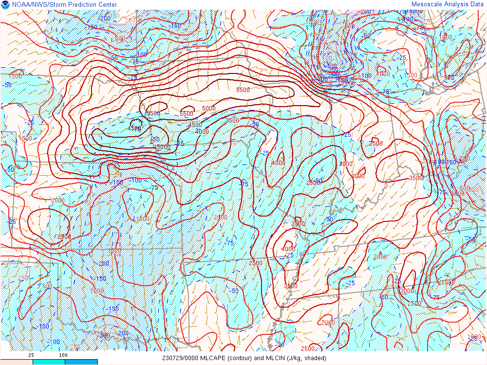 |
| Figure 1: 500 mb map at 06Z 29JUL23 - dashed line denotes trough axis | Figure 2: 850 mb map at 01Z 29JUL23 - doted line denotes moist axis | Figure 3: 0-6km Effective Shear at 03Z 29JUL23 | Figure 4: MLCAPE/MLCIN at 00Z 29JUL23 |
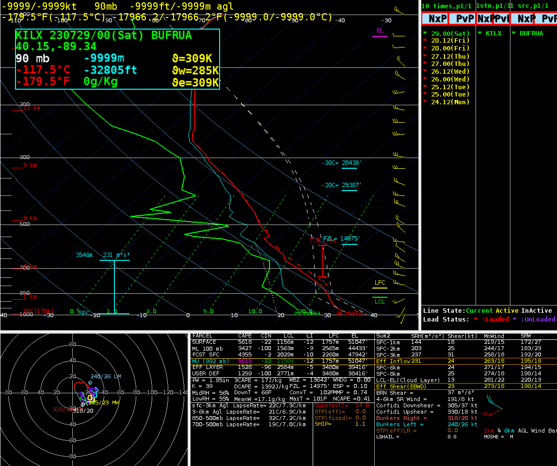
Near-storm environment summary.
 |
 |
 |
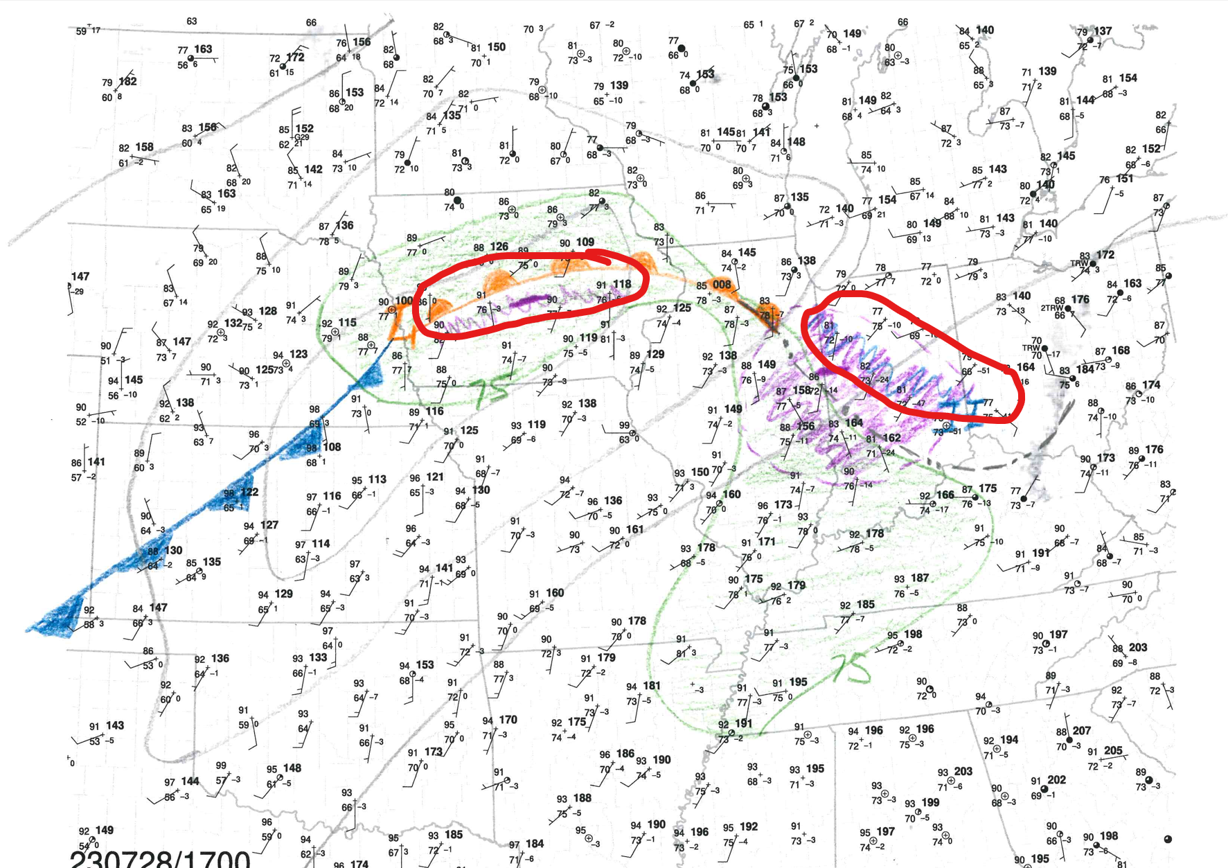 |
| Figure 5: ILX Sounding at 00Z 29JUL23 | Figure 6: Precipitable Water Analysis at 03Z 29JUL23 | Figure 7: GOES VIS at 0034Z | Figure 8: 28JUL23 17Z SFC Analysis - Red Ovals denote areas of expected explosive thunderstorm development |
Additional environmental data.
| Figure 9: Caption | Figure 10: Caption | Figure 11: Caption |
 |
Media use of NWS Web News Stories is encouraged! Please acknowledge the NWS as the source of any news information accessed from this site. |
|