Overview
Photos
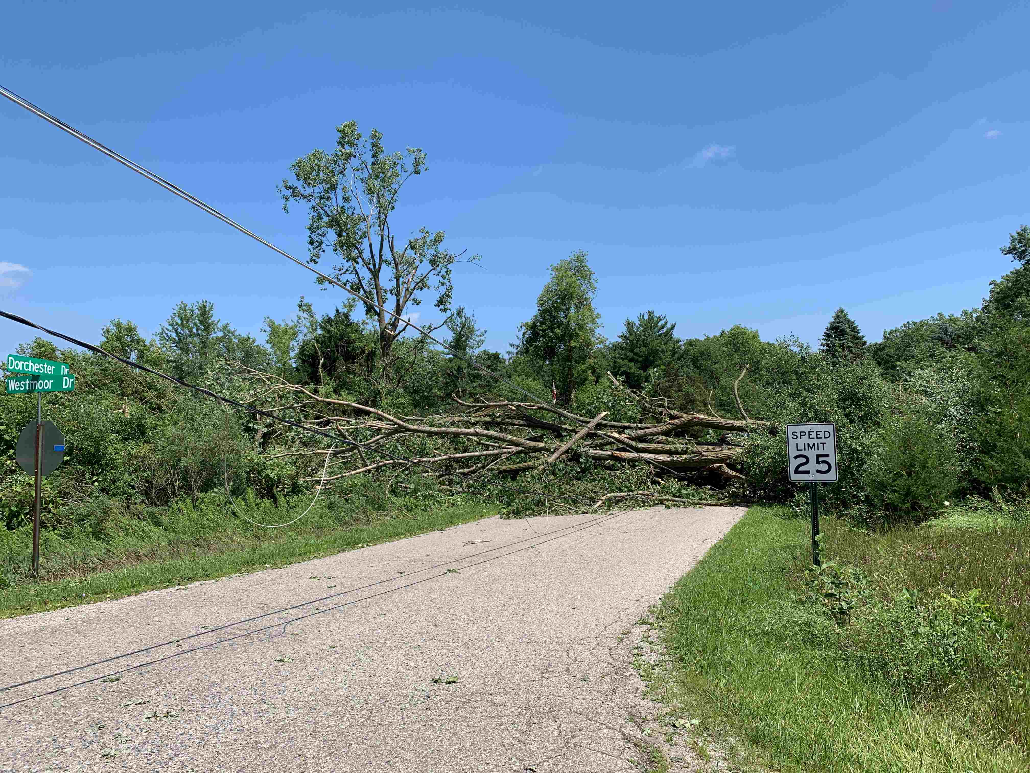
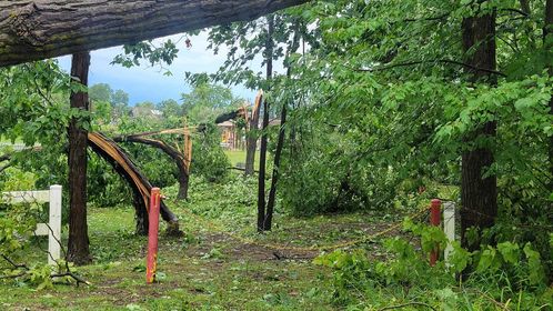
A downburst occurred over the eastern portion of Le Ann Lake on Waldron Road where trees were damaged and a sunroom on a west facing home had its roof lifted and thrown over the house. Damage was somewhat more limited east of Waldron Rd until approaching the western side of Lake Somerset where more concentrated tree damage along the west and north side of the lake. The extent of the tree damage was not widespread across this area, but the trees that were damaged were large and mainly healthy. Wind speeds of 70 to locally as much as 80 mph are estimated.
 |
 |
 |
 |
| Large, healthy branch snapped in LaGrange, IN. (Dave Caufield) |
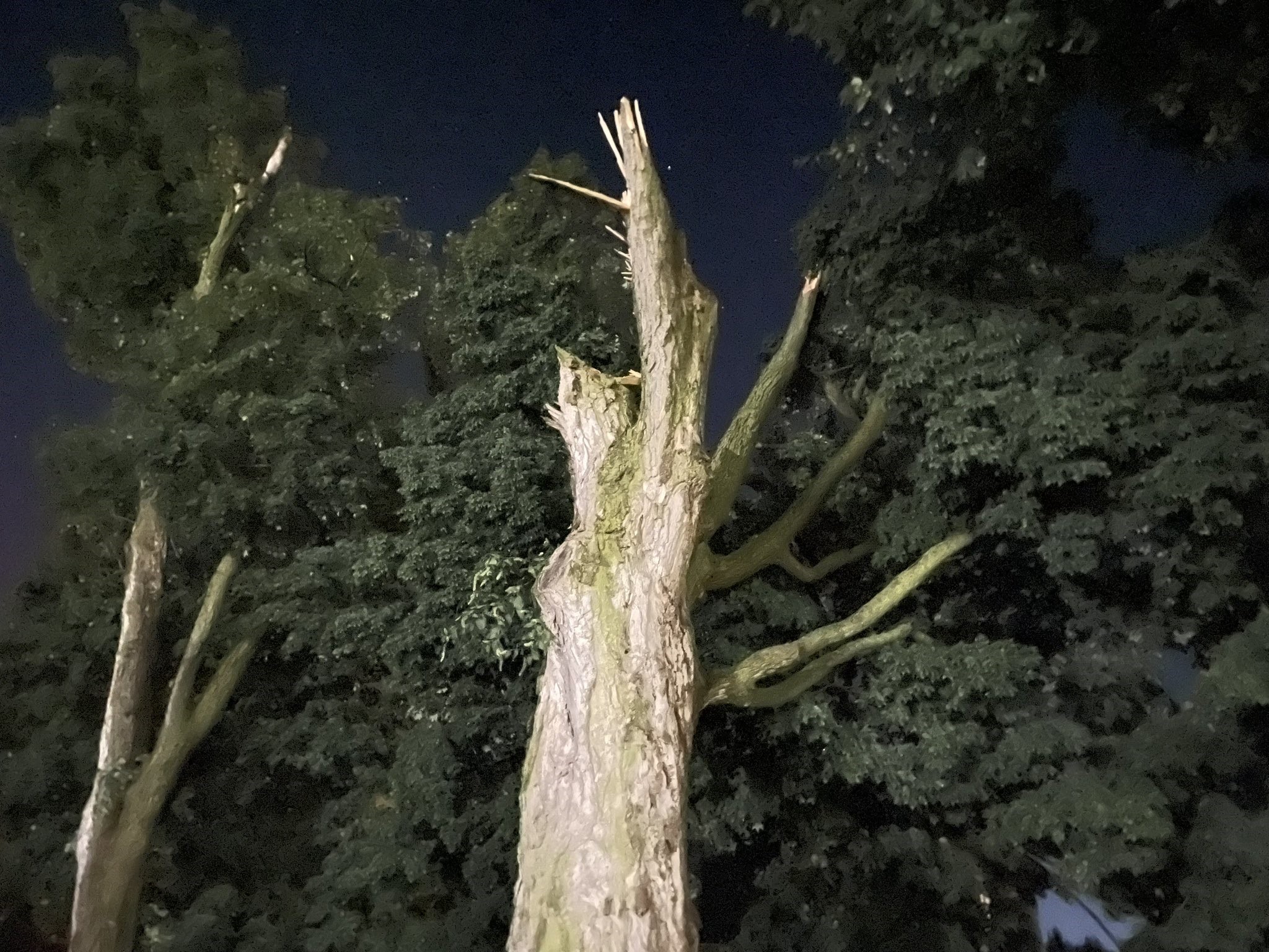
Tree snapped in LaGrange, IN. (Emmett Twomey) |
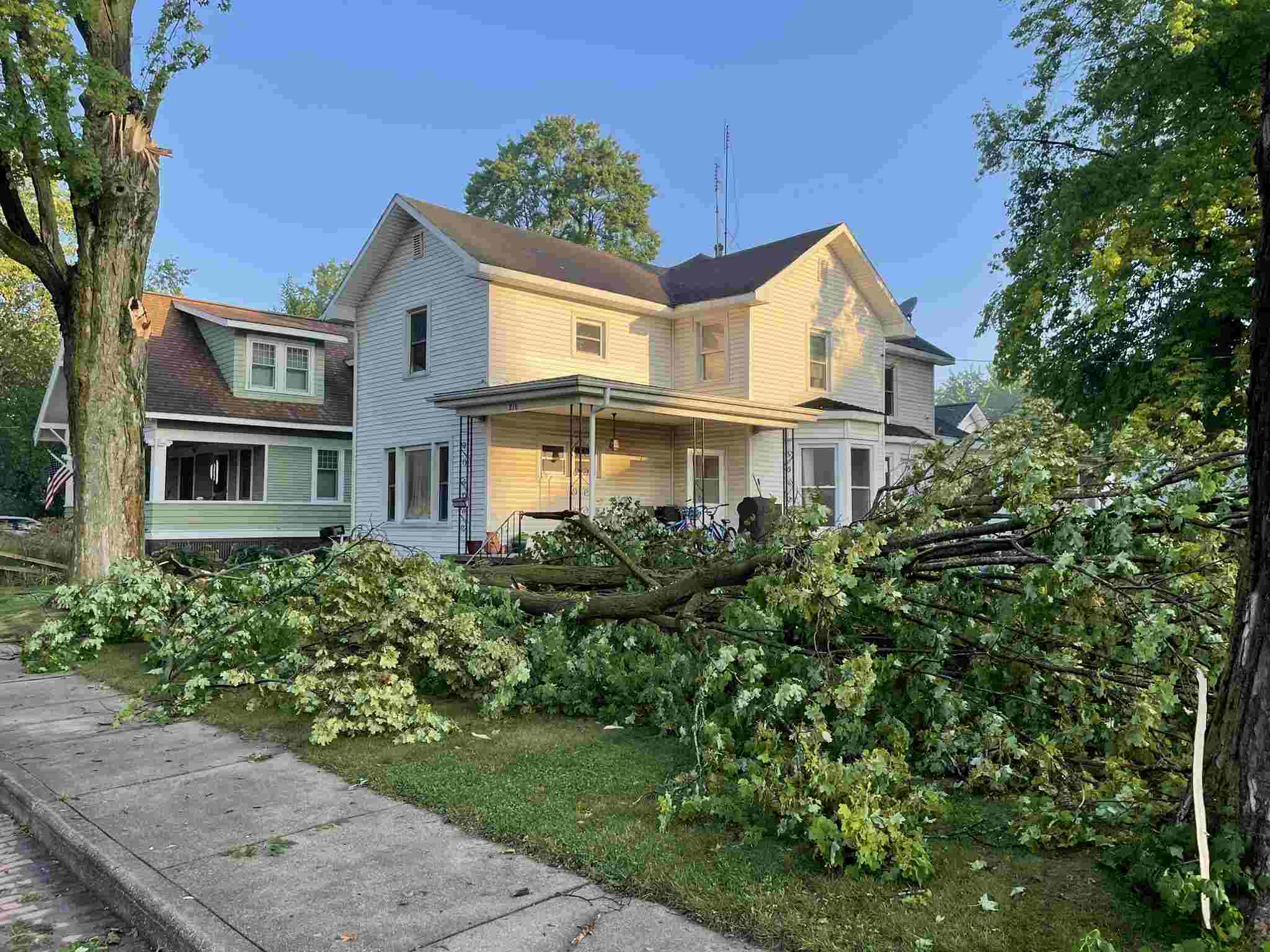
Large branches down in LaGrange, IN. (Emmett Twomey) |
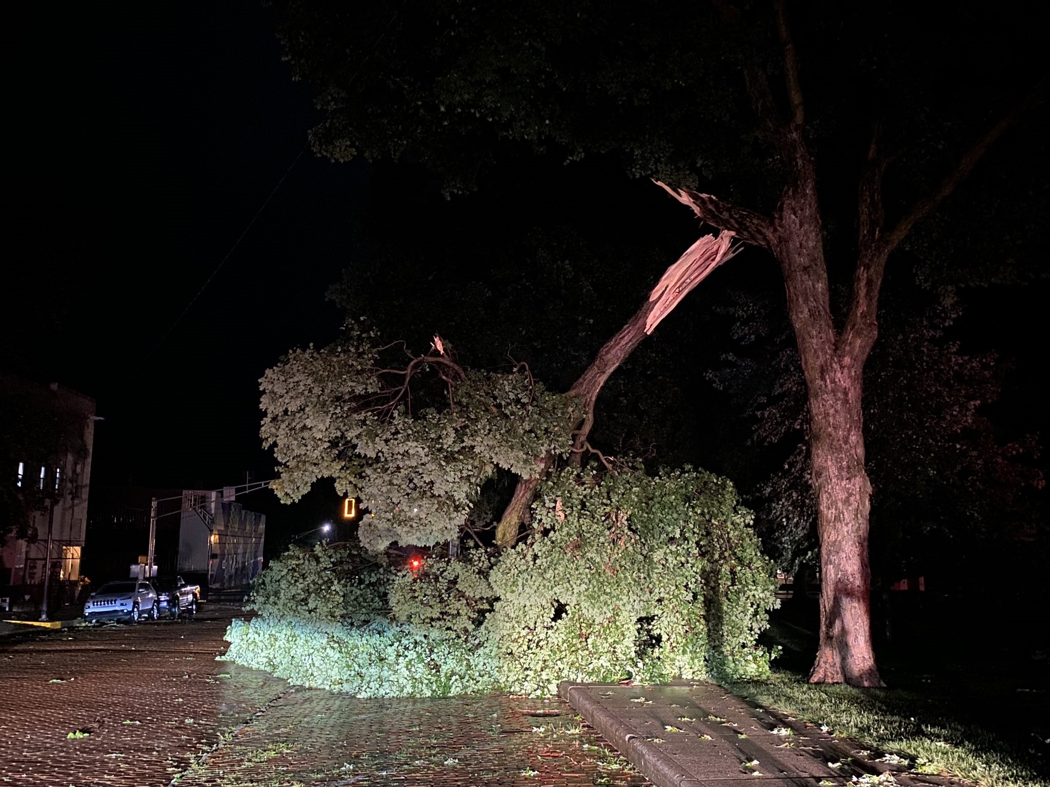
Tree down on a house (Bill Morr - LaGrange County Emergency Manager) |
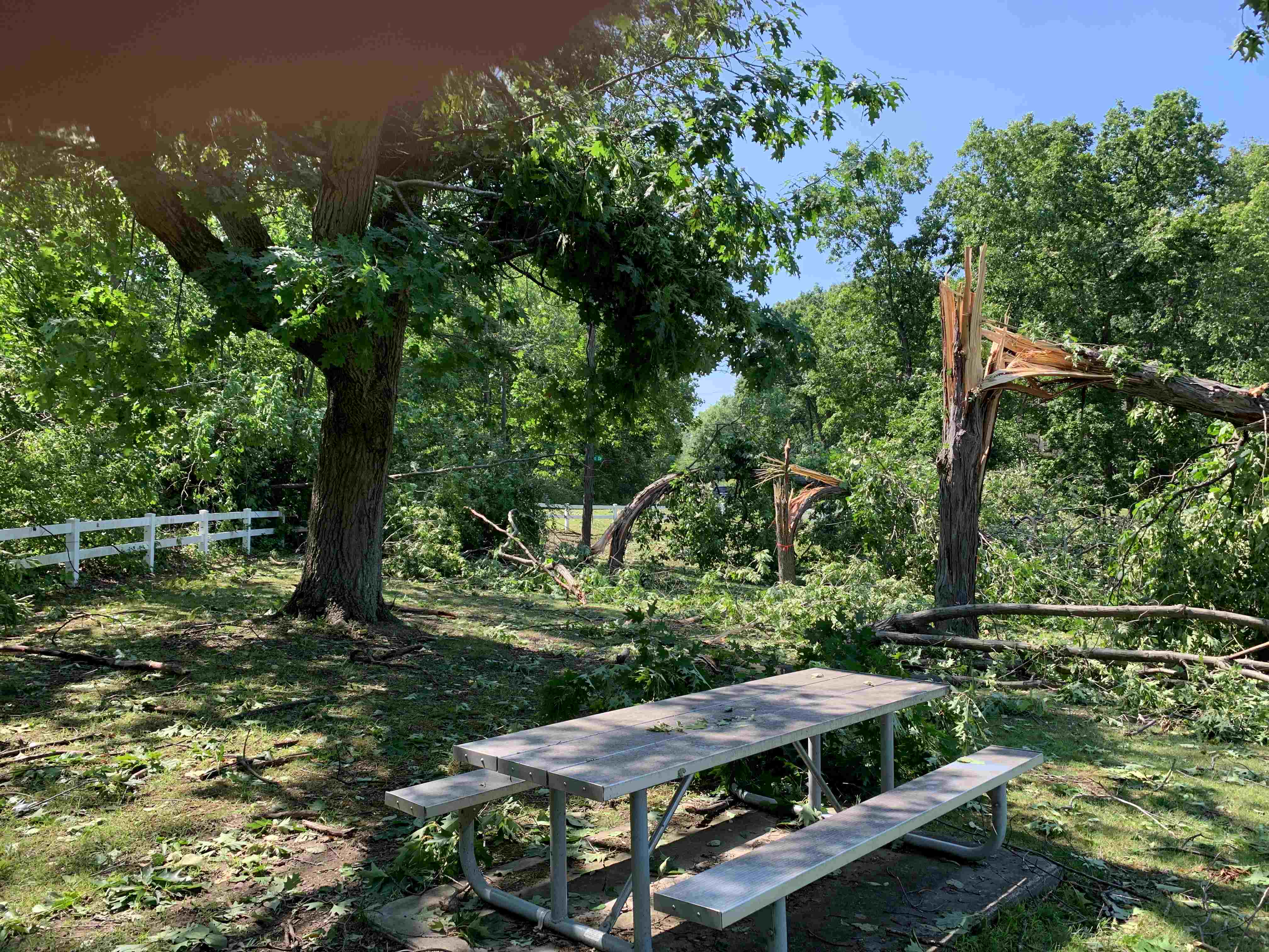
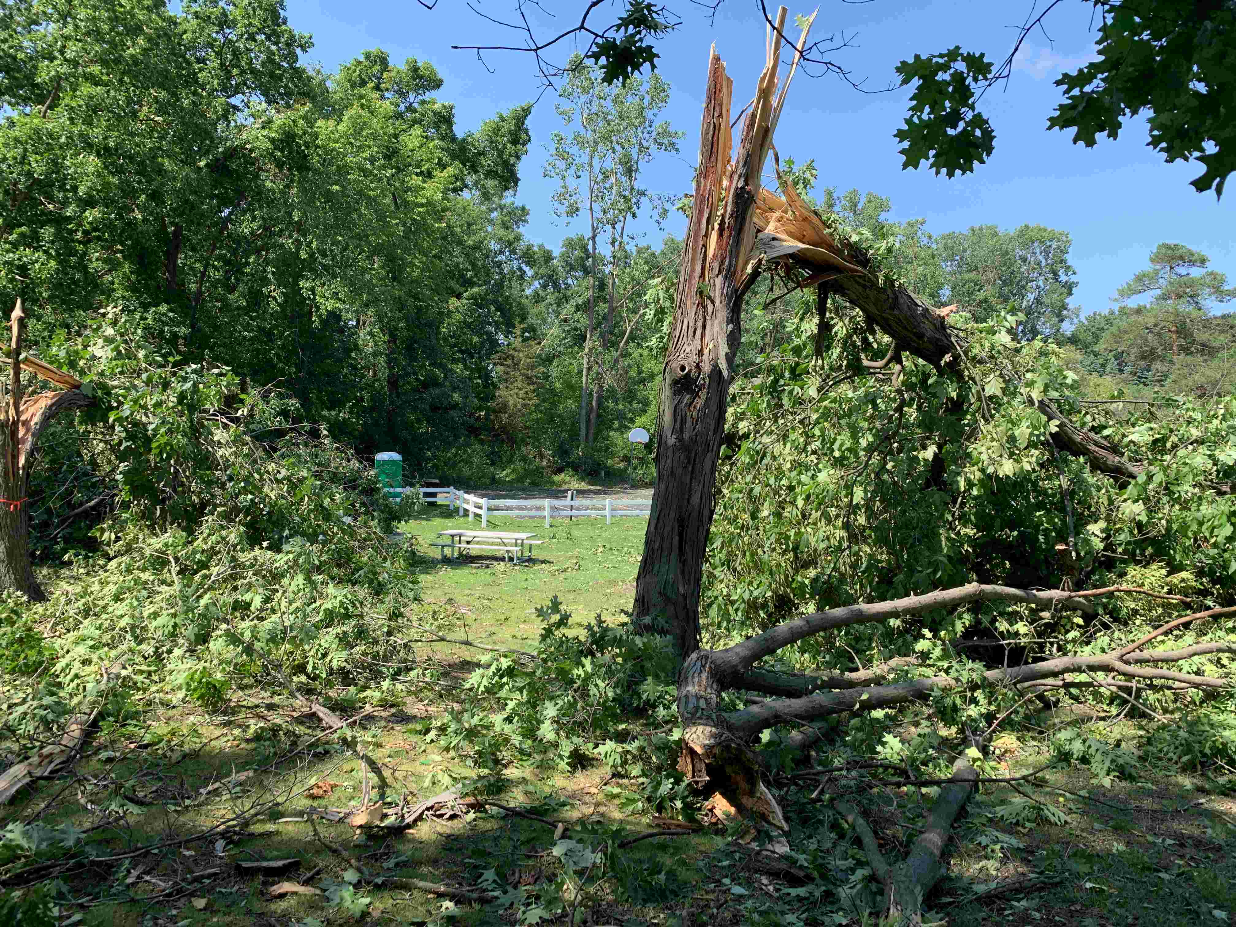
Straight-line wind of 70 to 75 mph was responsible for a 4-block area of tree damage in LaGrange, IN. Numerous large branches were down, some trees uprooted and powerlines were down. Structure damage was noted at some properties but only due to downed trees or branches.
 |
 |
 |
 |
| Downed tree Somerset Lake, MI NWS Storm Survey |
Tree snapped Somerset Lake, MI NWS Storm Survey |
Tree damage Somerset Lake, MI NWS Storm Survey |
Tree downed Somerset Lake, MI NWS Storm Survey |
 |
 |
 |
 |
| Tree damage in Hillsdale County, MI (Katie Bertke) |
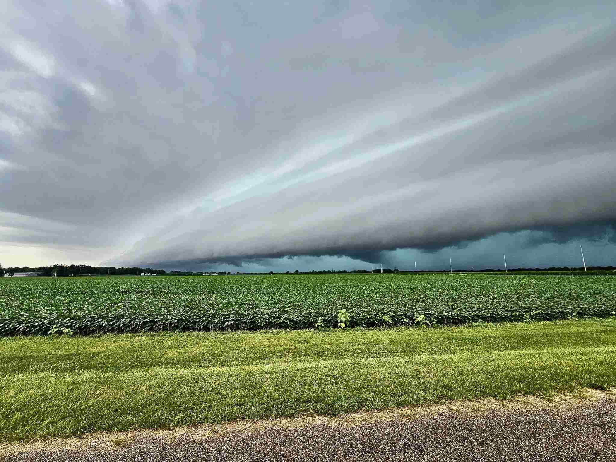
Shelf cloud approaching Mendon, MI. (Sierra Romeo) |
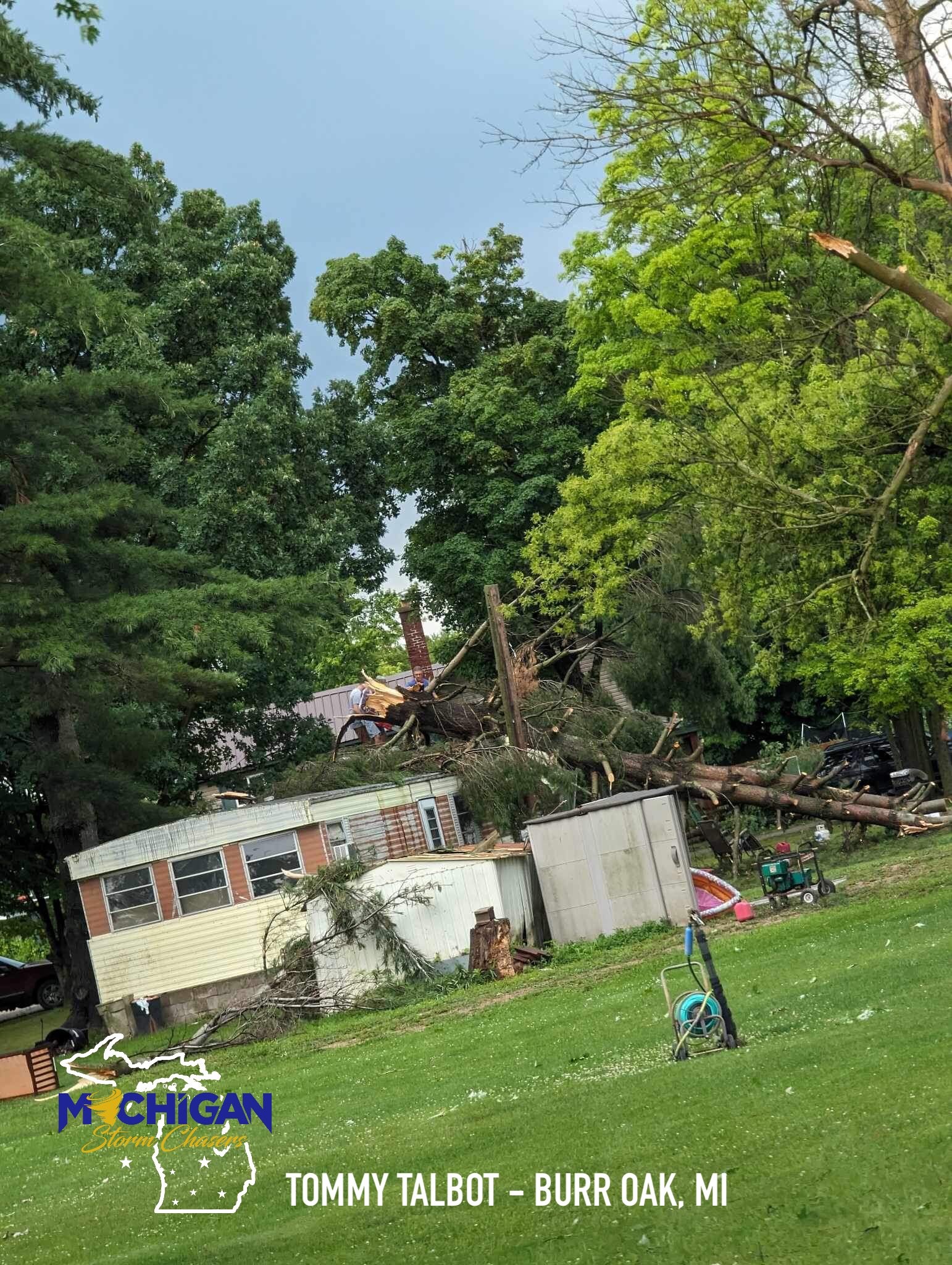
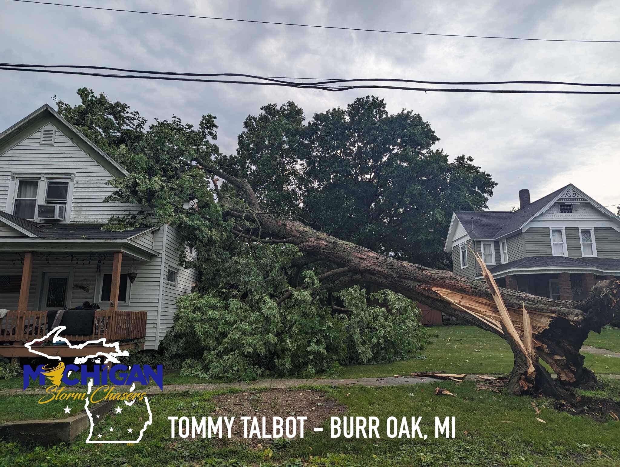
Tree snapped in Burr Oak, MI. (Tommy Talbot) |
Tree snapped, uprooted, in Burr Oak, MI. (Tommy Talbot) |
Radar and Rainfall Reports
In addition to the list of reports below, a map of CoCoRaHS rainfall observations can be found here.
 |
 |
 |
|
| 12 PM to 4PM EDT Radar Loop. | 6 PM to 11 PM Radar Loop | Radar loop starting just after 2pm and continuing until just after 2:30 showing the advance of strong damaging winds that hit Hillsdale county in Michigan. Storm relative velocity is in the upper right panel while velocity is in the bottom right panel. |
PUBLIC INFORMATION STATEMENT
NATIONAL WEATHER SERVICE NORTHERN INDIANA
1133 AM EDT THU JUL 27 2023

...24-HOUR PRECIPITATION REPORTS...

LOCATION                     AMOUNT    TIME/DATE       LAT/LON

...INDIANA...

...ADAMS COUNTY...
0.8 N LINN GROVE             0.02 IN   0745 PM 07/26   40.66N/85.03W

...ALLEN COUNTY...
HARLAN 2.2 ENE               0.36 IN   0700 AM 07/27   41.20N/84.88W
SPENCERVILLE                 0.36 IN   1115 AM 07/27   41.25N/84.89W
FORT WAYNE 10.4 N            0.26 IN   0700 AM 07/27   41.22N/85.14W
WOODBURN 2.6 NNW             0.24 IN   0900 AM 07/27   41.16N/84.88W
FORT WAYNE 9.1 SE            0.23 IN   0700 AM 07/27   40.99N/85.00W
FORT WAYNE 8.0 NE            0.20 IN   0930 AM 07/27   41.17N/85.05W
FORT WAYNE 4.1 NE            0.18 IN   0700 AM 07/27   41.12N/85.09W
MONROEVILLE 0.2 ESE          0.17 IN   0700 AM 07/27   40.97N/84.86W
FORT WAYNE 2.6 NW            0.17 IN   0700 AM 07/27   41.10N/85.18W
FORT WAYNE 8.0 N             0.16 IN   0700 AM 07/27   41.19N/85.11W
FORT WAYNE 6.0 N             0.15 IN   0700 AM 07/27   41.16N/85.13W
FORT WAYNE 2.6 NE            0.12 IN   0700 AM 07/27   41.10N/85.11W
FORT WAYNE 7.6 SE            0.07 IN   0700 AM 07/27   41.01N/85.02W
WOODBURN 2.8 WSW             0.07 IN   0700 AM 07/27   41.12N/84.91W
FORT WAYNE 6.8 NE            0.07 IN   0700 AM 07/27   41.13N/85.03W
FORT WAYNE 1.9 S             0.05 IN   0445 AM 07/27   41.05N/85.14W
FORT WAYNE 1.6 S             0.05 IN   0800 AM 07/27   41.05N/85.14W
ELLISVILLE 0.3 W             0.04 IN   0730 AM 07/27   41.02N/85.29W
HOAGLAND 1.5 SSW             0.03 IN   0740 AM 07/27   40.93N/85.00W
FORT WAYNE 9.3 W             0.02 IN   0700 AM 07/27   41.05N/85.31W
FORT WAYNE 8.7 W             0.02 IN   0700 AM 07/27   41.08N/85.31W
FORT WAYNE 7.1 WSW           0.01 IN   0800 AM 07/27   41.05N/85.27W
FORT WAYNE INTERNATIONAL AP   T IN     0754 PM 07/26   40.98N/85.18W

...BLACKFORD COUNTY...
(KA9VIS) HARTFORD CITY 0.7 N 0.03 IN   0700 AM 07/27   40.46N/85.37W
HARTFORD CITY 4 ESE          0.02 IN   0800 AM 07/27   40.44N/85.29W
HARTFORD CITY 0.2 NNW (WB9HL 0.01 IN   0800 AM 07/27   40.46N/85.37W

...CASS COUNTY...
GALVESTON                    0.20 IN   0745 PM 07/26   40.56N/86.19W
WALTON                       0.16 IN   0746 PM 07/26   40.66N/86.22W
YOUNG AMERICA                0.09 IN   0800 AM 07/27   40.57N/86.33W

...DE KALB COUNTY...
ASHLEY                       1.65 IN   1000 AM 07/27   41.51N/85.13W
HAMILTON 3.0 ESE             1.40 IN   0700 AM 07/27   41.52N/84.86W
1.7 SE BUTLER                0.87 IN   0800 AM 07/27   41.41N/84.85W
0.6 S GARRETT                0.69 IN   0700 AM 07/27   41.34N/85.13W
GARRETT                      0.46 IN   1120 AM 07/27   41.33N/85.13W
AUBURN 0.2 SE                0.28 IN   0800 PM 07/26   41.36N/85.05W

...ELKHART COUNTY...
ELKHART MUNICIPA             3.07 IN   1115 AM 07/27   41.72N/86.00W
GOSHEN 6.8 NE                2.55 IN   0700 AM 07/27   41.65N/85.75W
ELKHART 3.5 ENE              2.50 IN   0800 AM 07/27   41.70N/85.90W
GOSHEN 4.6 N                 2.41 IN   0700 AM 07/27   41.64N/85.83W
GOSHEN 3.5 NNW               2.12 IN   0700 AM 07/27   41.62N/85.87W
MIDDLEBURY                   1.65 IN   0140 PM 07/26   41.67N/85.71W
GOSHEN 0.3 NE                1.64 IN   0700 AM 07/27   41.58N/85.83W
GOSHEN 1.4 SSE               1.45 IN   0700 AM 07/27   41.56N/85.83W
GOSHEN 1.8 SE                1.43 IN   0700 AM 07/27   41.56N/85.81W
GOSHEN                       1.40 IN   1053 AM 07/27   41.53N/85.78W
GOSHEN 2.3 WNW               1.28 IN   0700 AM 07/27   41.59N/85.88W
SYRACUSE 4.4 NNW             1.26 IN   0700 AM 07/27   41.48N/85.77W
LIGONIER 4.3 WNW             1.24 IN   0800 AM 07/27   41.48N/85.67W
NAPPANEE 4.8 NE              1.19 IN   0700 AM 07/27   41.50N/85.92W
ELKHART 4.8 SW               1.07 IN   0600 AM 07/27   41.64N/86.04W
JAMESTOWN                    1.07 IN   1118 AM 07/27   41.64N/86.04W
JAMESTOWN                    1.06 IN   1000 PM 07/26   41.64N/86.04W
WAKARUSA 2.4 NNE             0.98 IN   0700 AM 07/27   41.57N/85.99W

...FULTON COUNTY...
ROCHESTER 2.4 NW             0.41 IN   0600 AM 07/27   41.09N/86.23W
ROCHESTER                    0.34 IN   0700 AM 07/27   41.07N/86.21W

...GRANT COUNTY...
MARION 6.5 N                 0.05 IN   0700 AM 07/27   40.64N/85.69W
(KC9QCJ) SHAMROCK LAKES 3.0  0.03 IN   0700 AM 07/27   40.45N/85.45W
MARION 1.8 NW                0.03 IN   0720 AM 07/27   40.57N/85.69W
2.2 N MARION                 0.01 IN   0700 AM 07/27   40.58N/85.66W

...HUNTINGTON COUNTY...
HUNTINGTON                   0.19 IN   1118 AM 07/27   40.83N/85.53W
2.4 NW WARREN                0.06 IN   0745 PM 07/26   40.71N/85.45W
HUNTINGTON 0.3 W             0.04 IN   0700 AM 07/27   40.88N/85.51W
1.7 E BOWERSTOWN             0.01 IN   0700 PM 07/26   40.90N/85.41W

...JAY COUNTY...
(KC9LQY) PORTLAND 5.4 SW     0.04 IN   0700 AM 07/27   40.39N/85.06W
(W9JKL) PORTLAND 0.6 SSW     0.03 IN   0700 AM 07/27   40.42N/84.99W
(WD9DCN) REDKEY 2.6 ENE      0.01 IN   0700 AM 07/27   40.37N/85.11W

...KOSCIUSKO COUNTY...
2 NW TIPPECANOE LAKE         1.44 IN   0630 AM 07/27   41.34N/85.78W
WARSAW 4.6 NNE               1.20 IN   0530 AM 07/27   41.30N/85.81W
SYRACUSE 3.0 ESE             1.08 IN   0800 AM 07/27   41.41N/85.70W
LEESBURG 0.1 WNW             1.06 IN   0600 AM 07/27   41.33N/85.85W
CROMWELL 2.9 W               1.03 IN   0700 AM 07/27   41.40N/85.67W
MILFORD 0.9 N                0.91 IN   0700 AM 07/27   41.42N/85.85W
WARSAW 1.2 NNE               0.79 IN   0700 AM 07/27   41.25N/85.84W
MILFORD 2.7 SSW              0.77 IN   0600 AM 07/27   41.38N/85.87W
WARSAW 3.0 SE                0.72 IN   0800 AM 07/27   41.21N/85.80W
WARSAW 1.4 N                 0.70 IN   0630 AM 07/27   41.26N/85.85W
2.3 N NORTH WEBSTER          0.70 IN   0800 AM 07/27   41.36N/85.70W
NORTH WEBSTER 2.3 N          0.70 IN   0800 AM 07/27   41.36N/85.70W
LEESBURG 6.7 ESE             0.58 IN   0700 AM 07/27   41.31N/85.72W
WARSAW 5.3 WNW               0.23 IN   0700 AM 07/27   41.27N/85.94W

...LA PORTE COUNTY...
0.8 W LA PORTE               0.18 IN   1258 AM 07/27   41.61N/86.73W
TRAIL CREEK 3.0 SE           0.17 IN   0800 AM 07/27   41.67N/86.81W
LA PORTE 2.3 ESE             0.13 IN   0930 AM 07/27   41.59N/86.68W
MILL CREEK 1.9 NNE           0.09 IN   0611 AM 07/27   41.61N/86.52W
LA PORTE 1.6 SW              0.09 IN   0800 AM 07/27   41.59N/86.73W
LA PORTE 6.8 SW              0.07 IN   0800 AM 07/27   41.55N/86.82W
LA PORTE                     0.03 IN   0755 PM 07/26   41.57N/86.73W

...LAGRANGE COUNTY...
LAGRANGE 1.3 ENE             2.44 IN   0615 AM 07/27   41.65N/85.40W
LAGRANGE 4.6 ESE             2.33 IN   0730 AM 07/27   41.62N/85.34W
WOLCOTTVILLE 1.1 WNW         2.10 IN   0806 AM 07/27   41.53N/85.39W
LAGRANGE 9.6 ESE             2.01 IN   0700 AM 07/27   41.59N/85.24W
LAGRANGE 9.9 E               1.66 IN   0625 AM 07/27   41.65N/85.23W

...MARSHALL COUNTY...
TIPPECANOE 0.8 S             0.57 IN   0700 AM 07/27   41.20N/86.11W
PLYMOUTH 2.5 WSW             0.16 IN   0500 AM 07/27   41.33N/86.36W

...MIAMI COUNTY...
PERU                         0.82 IN   1030 AM 07/27   40.75N/86.07W
AMBOY                        0.14 IN   1115 AM 07/27   40.59N/85.98W
MACY 2.7 SSE                 0.06 IN   0700 AM 07/27   40.92N/86.12W
0.8 NW PERU                  0.05 IN   0700 AM 07/27   40.76N/86.07W
DENVER 0.5 SSE               0.05 IN   0700 AM 07/27   40.86N/86.07W
DENVER 1.3 NE                0.02 IN   0700 AM 07/27   40.88N/86.06W

...NOBLE COUNTY...
KENDALLVILLE 4.5 NW          1.73 IN   0700 AM 07/27   41.50N/85.31W
KENDALLVILLE 2.2 SW          1.58 IN   0800 AM 07/27   41.42N/85.29W
KENDALLVILLE 3.2 N           1.54 IN   0621 AM 07/27   41.49N/85.26W
KENDALLVILLE                 1.11 IN   1035 AM 07/27   41.47N/85.25W
ALBION 2.8 ENE               0.84 IN   0730 AM 07/27   41.40N/85.37W

...PULASKI COUNTY...
MONTEREY 2.2 WNW             0.01 IN   0800 AM 07/27   41.17N/86.52W

...ST. JOSEPH COUNTY...
GRANGER 1.8 ENE              2.35 IN   0700 AM 07/27   41.75N/86.11W
GRANGER                      1.50 IN   0148 PM 07/26   41.74N/86.14W
MISHAWAKA 3.9 ENE            1.24 IN   0730 AM 07/27   41.68N/86.10W
SOUTH BEND INTERNATIONAL AP  1.06 IN   0754 PM 07/26   41.70N/86.32W
NEW CARLISLE                 0.71 IN   0730 AM 07/27   41.71N/86.50W
MISHAWAKA 2.0 E              0.70 IN   0700 AM 07/27   41.66N/86.13W
SOUTH BEND 4.6 SE            0.63 IN   0700 AM 07/27   41.62N/86.22W
SOUTH BEND 3.3 SE            0.41 IN   0700 AM 07/27   41.64N/86.23W
SOUTH BEND 4.6 SSE           0.24 IN   0839 AM 07/27   41.61N/86.24W

...STARKE COUNTY...
WINONA                       0.04 IN   0800 AM 07/27   41.24N/86.57W
3.5 N BREMS                  0.03 IN   1000 PM 07/26   41.39N/86.71W

...STEUBEN COUNTY...
HUDSON 4.6 N                 1.76 IN   0715 AM 07/27   41.60N/85.09W
HUDSON 6.4 WNW               1.73 IN   0800 AM 07/27   41.58N/85.19W
ANGOLA 4.1 N                 1.68 IN   0545 AM 07/27   41.70N/84.99W
ANGOLA 4.5 NW                1.65 IN   0700 AM 07/27   41.68N/85.07W
ANGOLA                       1.57 IN   1115 AM 07/27   41.63N/85.09W
HUDSON 4.1 NNW               1.53 IN   0700 AM 07/27   41.59N/85.10W
ANGOLA 6.2 NW                1.44 IN   0700 AM 07/27   41.71N/85.07W
HAMILTON 1.7 E               1.35 IN   0700 AM 07/27   41.53N/84.89W
HUDSON 0.3 SE                1.34 IN   0529 AM 07/27   41.53N/85.08W
ANGOLA 1.2 S                 1.28 IN   0600 AM 07/27   41.62N/85.00W
HUDSON                       1.25 IN   0400 PM 07/26   41.53N/85.08W
0.7 E HAMILTON               1.11 IN   1045 AM 07/27   41.53N/84.90W
ANGOLA 8.7 ESE               1.02 IN   0700 AM 07/27   41.61N/84.84W
ANGOLA 8.8 ESE               1.00 IN   0800 AM 07/27   41.62N/84.83W
0.7 E HAMILTON               0.99 IN   0745 PM 07/26   41.53N/84.90W
PIGEON CREEK                 0.76 IN   0715 PM 07/26   41.63N/85.11W

...WABASH COUNTY...
WABASH 0.3 NNW               0.11 IN   0600 AM 07/27   40.80N/85.83W
WABASH 1.5 SW                0.11 IN   0700 AM 07/27   40.78N/85.84W
LA FONTAINE 0.3 SE           0.06 IN   0726 AM 07/27   40.67N/85.72W
0.7 SE WABASH                0.05 IN   0730 PM 07/26   40.79N/85.82W
LA FONTAINE 1.1 NW           0.03 IN   0700 AM 07/27   40.68N/85.74W

...WELLS COUNTY...
BLUFFTON                     0.08 IN   0745 PM 07/26   40.74N/85.17W
BLUFFTON 0.9 SE              0.07 IN   0700 AM 07/27   40.73N/85.16W

...WHITE COUNTY...
MONTICELLO - WHITE COUNTY AR 0.34 IN   0755 PM 07/26   40.72N/86.77W
MONTICELLO 0.9 E             0.23 IN   0700 AM 07/27   40.75N/86.75W
NORWAY                       0.18 IN   0745 PM 07/26   40.78N/86.76W
5.6 N BADGER GROVE           0.08 IN   0700 AM 07/27   40.67N/86.95W

...WHITLEY COUNTY...
COLUMBIA CITY 7.4 N          0.22 IN   0639 AM 07/27   41.26N/85.50W
COLUMBIA CITY 4.6 S          0.21 IN   0600 AM 07/27   41.09N/85.47W
TRI-LAKES 3.0 N              0.21 IN   0700 AM 07/27   41.26N/85.49W
COLUMBIA CITY 6.8 NNE        0.18 IN   0700 AM 07/27   41.25N/85.42W
COLUMBIA CITY 5.4 N          0.10 IN   0630 AM 07/27   41.24N/85.49W
COLUMBIA CITY 0.5 WSW        0.03 IN   0729 AM 07/27   41.16N/85.49W
COLUMBIA CITY 0.2 NE         0.02 IN   0617 AM 07/27   41.16N/85.48W

...MICHIGAN...

...BERRIEN COUNTY...
3.7 S WATERVLIET             2.11 IN   1100 AM 07/27   42.13N/86.25W
NILES 2.7 W                  1.75 IN   0800 AM 07/27   41.84N/86.30W
BERTRAND                     1.69 IN   0800 AM 07/27   41.77N/86.26W
NILES                        1.39 IN   0759 PM 07/26   41.83N/86.25W
BUCHANAN 1.4 ESE             1.36 IN   0700 AM 07/27   41.82N/86.34W
ST. JOSEPH 2.8 SSE           1.33 IN   0700 AM 07/27   42.06N/86.47W
BENTON HARBOR                1.28 IN   0806 PM 07/26   42.13N/86.42W
3 ESE BERRIEN SPRINGS        1.18 IN   0122 PM 07/26   41.93N/86.30W
ST. JOSEPH 1.5 SSE           1.15 IN   0700 AM 07/27   42.08N/86.48W
SHOREHAM 2.0 SE              1.08 IN   0800 AM 07/27   42.03N/86.49W
STEVENSVILLE 1.7 SSE         0.90 IN   0530 AM 07/27   41.99N/86.51W

...BRANCH COUNTY...
QUINCY 0.3 NE                2.51 IN   0700 AM 07/27   41.95N/84.88W

...CASS COUNTY...
CASSOPOLIS 9.0 SSE           1.86 IN   0700 AM 07/27   41.79N/85.95W
NILES 3.5 E                  1.59 IN   0900 AM 07/27   41.84N/86.18W
2 NNW EDWARDSBURG            1.38 IN   0700 AM 07/27   41.84N/86.10W

...HILLSDALE COUNTY...
MOSCOW 1.0 NE                3.41 IN   0700 AM 07/27   42.06N/84.50W
OSSEO 2.7 NE                 2.83 IN   0830 AM 07/27   41.90N/84.49W
HILLSDALE 2.5 ESE            2.79 IN   0800 AM 07/27   41.91N/84.59W
HILLSDALE                    2.27 IN   1115 AM 07/27   41.92N/84.58W
JONESVILLE 5.9 ENE           2.23 IN   0700 AM 07/27   42.01N/84.56W
LITCHFIELD 0.3 ENE           2.03 IN   0705 AM 07/27   42.05N/84.75W
JONESVILLE 0.2 WSW           1.83 IN   0710 AM 07/27   41.98N/84.67W

...ST. JOSEPH COUNTY...
THREE RIVERS 2.4 NE          2.43 IN   0639 AM 07/27   41.97N/85.60W
CONSTANTINE 1.9 E            2.23 IN   0700 AM 07/27   41.84N/85.63W
2.0 SE MENDON                2.16 IN   1100 AM 07/27   41.98N/85.43W
STURGIS KIRSCH               1.15 IN   0755 PM 07/26   41.80N/85.43W

...OHIO...

...ALLEN COUNTY...
BLUFFTON                     0.10 IN   1110 AM 07/27   40.89N/83.89W
ELIDA 1.4 WNW                0.03 IN   0624 AM 07/27   40.80N/84.22W
LIMA 7.3 SE                  0.03 IN   0700 AM 07/27   40.66N/84.03W

...DEFIANCE COUNTY...
DEFIANCE                     0.74 IN   1053 AM 07/27   41.33N/84.43W

...FULTON COUNTY...
FAYETTE 4.3 ESE              1.79 IN   0700 AM 07/27   41.65N/84.25W
WAUSEON 1.8 S                1.60 IN   0700 AM 07/27   41.53N/84.14W
SWANTON 4.0 S                1.18 IN   0702 AM 07/27   41.53N/83.91W
4.6 SW MORENCI  (R2)  (R2)   1.10 IN   1100 AM 07/27   41.66N/84.25W
ARCHBOLD 4.7 NW              0.96 IN   0530 AM 07/27   41.57N/84.36W

...HENRY COUNTY...
LIBERTY CENTER 0.3 NE        1.06 IN   0700 AM 07/27   41.45N/84.00W
NAPOLEON 1 SW                0.76 IN   0700 AM 07/27   41.38N/84.15W
NAPOLEON 4.5 NNW             0.69 IN   0700 AM 07/27   41.46N/84.15W
NAPOLEON 1.2 SSE             0.69 IN   0700 AM 07/27   41.38N/84.12W
NAPOLEON 0.6 WSW             0.68 IN   0800 AM 07/27   41.39N/84.14W
NEW BAVARIA 2.3 WSW          0.61 IN   0700 AM 07/27   41.19N/84.21W

...PAULDING COUNTY...
PAULDING 1.4 NNE             0.64 IN   0700 AM 07/27   41.15N/84.57W

...PUTNAM COUNTY...
LEIPSIC 5.4 W                0.17 IN   0700 AM 07/27   41.11N/84.09W
VAUGHNSVILLE                 0.08 IN   1115 AM 07/27   40.88N/84.15W

...VAN WERT COUNTY...
VAN WERT                     0.05 IN   1118 AM 07/27   40.87N/84.59W

...WILLIAMS COUNTY...
ALVORDTON 0.5 E              2.54 IN   0700 AM 07/27   41.67N/84.42W
PIONEER 2.3 S                1.87 IN   0700 AM 07/27   41.65N/84.55W
EDON 4 S                     0.74 IN   0400 PM 07/26   41.50N/84.77W
1.2 E BRYAN                  0.70 IN   0800 AM 07/27   41.46N/84.53W

OBSERVATIONS ARE COLLECTED FROM A VARIETY OF SOURCES WITH VARYING
EQUIPMENT AND EXPOSURES. WE THANK ALL VOLUNTEER WEATHER OBSERVERS
FOR THEIR DEDICATION. NOT ALL DATA LISTED ARE CONSIDERED OFFICIAL.

$$
Storm Reports
Preliminary Local Storm Report...Summary
National Weather Service Northern Indiana
1149 PM EDT Wed Jul 26 2023

..TIME...   ...EVENT...      ...CITY LOCATION...     ...LAT.LON...
..DATE...   ....MAG....      ..COUNTY LOCATION..ST.. ...SOURCE....
            ..REMARKS..

1215 PM     Tstm Wnd Dmg     2 WSW Michigan City     41.70N 86.90W
07/26/2023                   La Porte           IN   Public

            Multiple reports of trees down on Ohio
            Street in Michigan City, near the
            intersection with Garfield Street. No
            specifics of the size of trees. Time
            estimated via radar.

0122 PM     Rain             3 SE Berrien Springs    41.93N 86.30W
07/26/2023  M1.18 inch       Berrien            MI   Public


0125 PM     Tstm Wnd Dmg     1 SSE Sturgis           41.79N 85.42W
07/26/2023                   St. Joseph         MI   Broadcast Media

            Large tree down in Sturgis, MI at the
            intersection of South Ottawa Street and
            Cottage Road. Time estimated via radar.

0130 PM     Tstm Wnd Dmg     Sturgis                 41.80N 85.42W
07/26/2023                   St. Joseph         MI   Trained Spotter

            Multiple trees down in Sturgis along Hwy 66.

0130 PM     Tstm Wnd Dmg     Burr Oak                41.85N 85.32W
07/26/2023                   St. Joseph         MI   Trained Spotter

            Numerous trees snapped and/or uprooted in
            Burr Oak. Time estimated by radar. Photos on
            Twitter.

0130 PM     Tstm Wnd Dmg     2 S Sturgis             41.77N 85.42W
07/26/2023                   St. Joseph         MI   Public

            Tree limbs down, fence damaged, and a house
            with siding damage in Sturgis on Bogen Rd.
            Time estimated via radar.

0140 PM     Rain             Middlebury              41.67N 85.71W
07/26/2023  M1.65 inch       Elkhart            IN   Public

            Public report on Facebook of 1.65 inches of
            rain recorded in Middlebury between 1:10 PM
            and 1:40 PM EDT.

0144 PM     Tstm Wnd Dmg     Orland                  41.73N 85.17W
07/26/2023                   Steuben            IN   Trained Spotter

            24 to 30 inch diameter tree down at the
            intersection of SR 120 and 900W. Time
            estimated via radar.

0145 PM     Tstm Wnd Gst     1 NNW Hodunk            42.03N 85.07W
07/26/2023  E60 MPH          Branch             MI   Trained Spotter

            Delayed report. Trained Spotter estimates
            wind gusts 60 MPH at Olds Rd and Union City
            Rd.

0148 PM     Tstm Wnd Dmg     Cassopolis              41.91N 86.01W
07/26/2023                   Cass               MI   Broadcast Media

            A few large tree branches down in
            Cassopolis, including one onto an unoccupied
            car. Time estimated from radar.

0148 PM     Rain             Granger                 41.74N 86.14W
07/26/2023  M1.50 inch       St. Joseph         IN   Public


0150 PM     Tstm Wnd Dmg     Topeka                  41.54N 85.54W
07/26/2023                   Lagrange           IN   Broadcast Media

            Damage to roofs on two barns in Topeka. Time
            estimated via radar. Photo on Twitter.

0150 PM     Tstm Wnd Dmg     Howe                    41.72N 85.42W
07/26/2023                   Lagrange           IN   Trained Spotter

            4 healthy trees/branches down, largest 12
            inches in diameter at Ln 3 and 3rd Street.

0155 PM     Tstm Wnd Dmg     Diamond Lake            41.90N 85.98W
07/26/2023                   Cass               MI   Broadcast Media

            Large tree limbs down onto powerlines on the
            south side of Diamond Lake along Diamond
            View Drive. Time estimated via radar.

0225 PM     Tstm Wnd Dmg     Somerset Center         42.05N 84.42W
07/26/2023                   Hillsdale          MI   Trained Spotter

            Spotter reports numerous large trees
            uprooted or down at the trailer park in
            Somerset Center. Time estimated via radar.
            Photos on Twitter.

0230 PM     Tstm Wnd Dmg     Jerome                  42.02N 84.46W
07/26/2023                   Hillsdale          MI   Trained Spotter

            Delayed report. Several large trees snapped
            on Jerome Road and at the Jerome Rd and
            Sandhill Rd intersection.

0240 PM     Tstm Wnd Dmg     West Unity              41.59N 84.43W
07/26/2023                   Williams           OH   Public

            Large tree limbs snapped in West Unity.
            Photo on Facebook. Tim estimated via radar.

0240 PM     Tstm Wnd Dmg     1 N Edgerton            41.45N 84.75W
07/26/2023                   Williams           OH   Public

            Photos on Twitter depict several large tree
            limbs and one large tree down In Edgerton.
            Near the intersection of North Michigan
            Avenue and Gas Street. Time estimated by
            radar.

0304 PM     Tstm Wnd Dmg     3 NE Gallup             41.49N 84.12W
07/26/2023                   Fulton             OH   Emergency Mngr

            Emergency Manager reports tree down on the
            Henry/Fulton county line. Near the
            intersection of Co Rd 13 and County Rd A.

0318 PM     Tstm Wnd Dmg     1 W Colton              41.46N 83.98W
07/26/2023                   Henry              OH   Emergency Mngr

            On CR 6 between CR U and U-4 approx 0.5
            miles of downed trees and power lines downed
            and smoking. Time estimated by radar.

0400 PM     Rain             Hudson                  41.53N 85.08W
07/26/2023  M1.25 inch       Steuben            IN   Public


0612 PM     Tstm Wnd Gst     Colon                   41.96N 85.33W
07/26/2023  E70 MPH          St. Joseph         MI   Trained Spotter

            Spotter estimates 70 MPH wind gusts. Trees
            down and crops blown over.

0700 PM     Rain             2 SSE Mendon            41.98N 85.43W
07/26/2023  M1.93 inch       St. Joseph         MI   CO-OP Observer

            CO-OP Observer station MUNM4 2.0 SE Mendon.

0700 PM     Rain             4 S Watervliet          42.13N 86.25W
07/26/2023  M2.07 inch       Berrien            MI   CO-OP Observer

            CO-OP Observer station WRTM4 3.7 S
            Watervliet.

0739 PM     Tstm Wnd Dmg     Union City              42.07N 85.14W
07/26/2023                   Branch             MI   Trained Spotter

            Twitter report of trees and powerlines down
            in Union City. M60 is shut down by Michigan
            State Police as it is almost impassable in
            spots.

0940 PM     Tstm Wnd Dmg     Lagrange                41.64N 85.42W
07/26/2023                   Lagrange           IN   Emergency Mngr

            Emergency manager reports multiple trees
            down.

0955 PM     Rain             3 NW Elkhart            41.72N 86.00W
07/26/2023  M3.01 inch       Elkhart            IN   AWOS

            AWOS station KEKM Elkhart Municipa.

0956 PM     Tstm Wnd Gst     2 NW Benton             41.53N 85.78W
07/26/2023  M60 MPH          Elkhart            IN   ASOS

            Corrects previous non-tstm wnd gst report
            from 2 NW Benton. ASOS station KGSH Goshen.
Environment
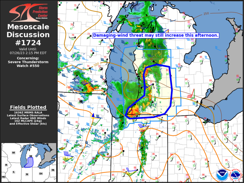
A number of Mesoscale Discussions were issued by the Storm Prediction Center on this date.
 |
 |
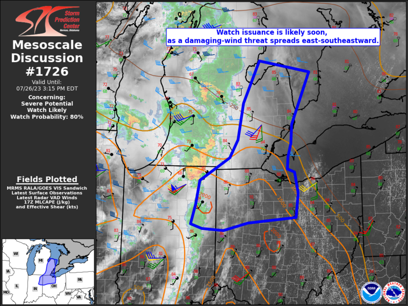 |
| Figure 1: MD 1723 describes thunderstorms approaching improved instability and increasing deep layer shear. | Figure 2: MD 1724 indicates a potential for "...increasingly organized damaging-wind threat across southern MI" | Figure 3: MD 1726 indicates the ongoing line of thunderstorms will encounter a favorable severe thunderstorm environment. |
 |
 |
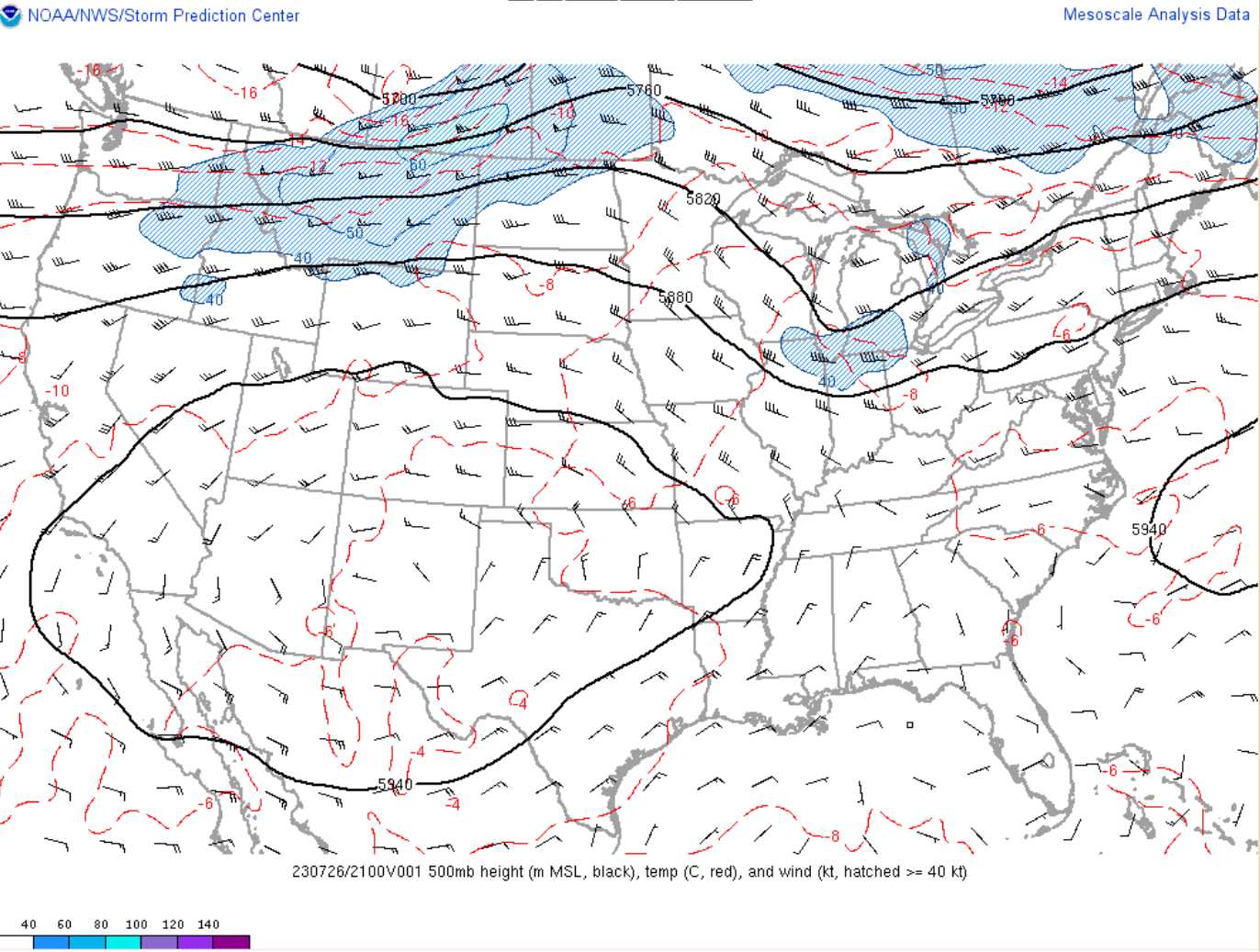 |
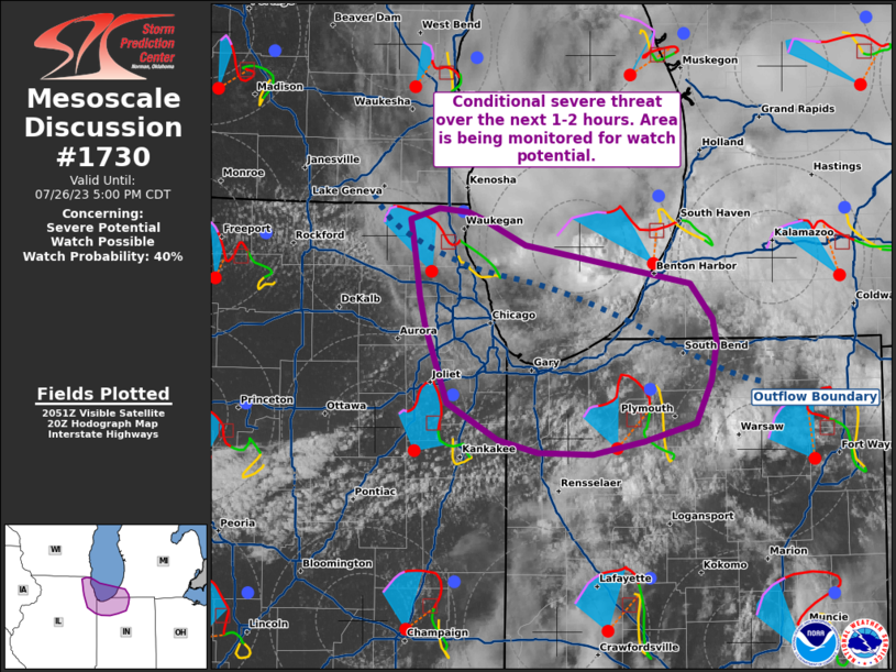
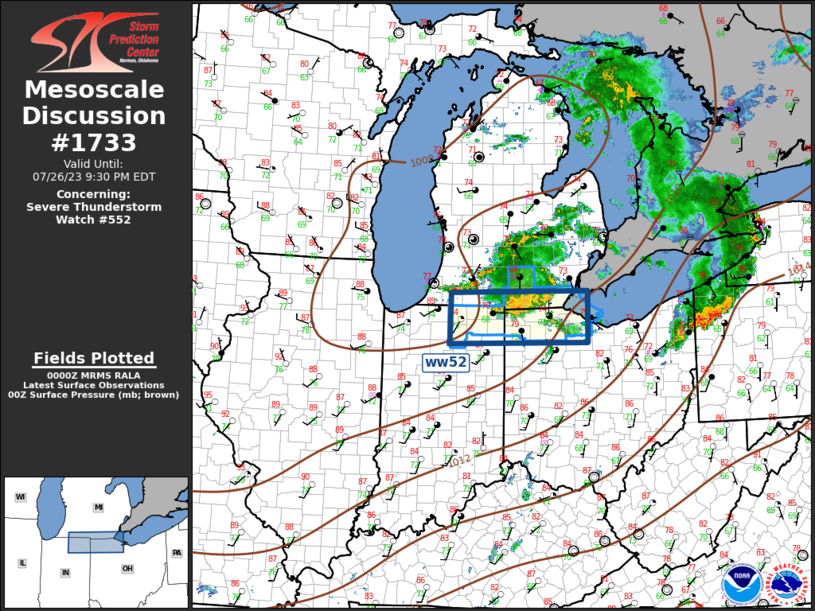
| Figure 4: MD 1730 states that northern Indiana was being monitored for severe thunderstorm development was possible along an outflow boundary left behind from storms earlier in the day. | Figure 5: MD 1733 describes the ongoing wind threat for northwest Ohio. | Figure 6: 500-mb heights at 6PM EDT. A shortwave trough moving through helped sustain the threat of severe thunderstorms late in the day. See a loop of these charts here. |
 |
Media use of NWS Web News Stories is encouraged! Please acknowledge the NWS as the source of any news information accessed from this site. |
|

