Overview of Dec 22-24, 2022 Winter Storm
Event Highlights
Snow
Snow totals were low over much of northern Indiana and northwest Ohio. However, when paired with the flash freeze, observed 50 mph wind gusts, blowing and drifting snow caused significant problems on area roadways. In the days leading up to this event, forecasters were confident that even if only a couple of inches of snow fell, travel would be difficult to impossible. Snowplows in some counties were parked on December 23rd due to the fierce winds negating successful plow operations in rural areas. Extreme cold caused equipment malfunctions as well.
In far northwest Indiana and far southwest Michigan, lake effect snow totaled 6 to 16.3 inches over a 3-day period. Blizzard conditions were realized. Travel was impossible at times on major routes such as I-94 in Michigan and US 31.
.png)
Photos & Video
Photos
 |
 |
 |
 |
|
Whiteout conditions in Three Oaks, MI |
Snow drifts were significant, especially in southwest Michigan as seen here in Sodus, MI. (Emmett Twomey) |
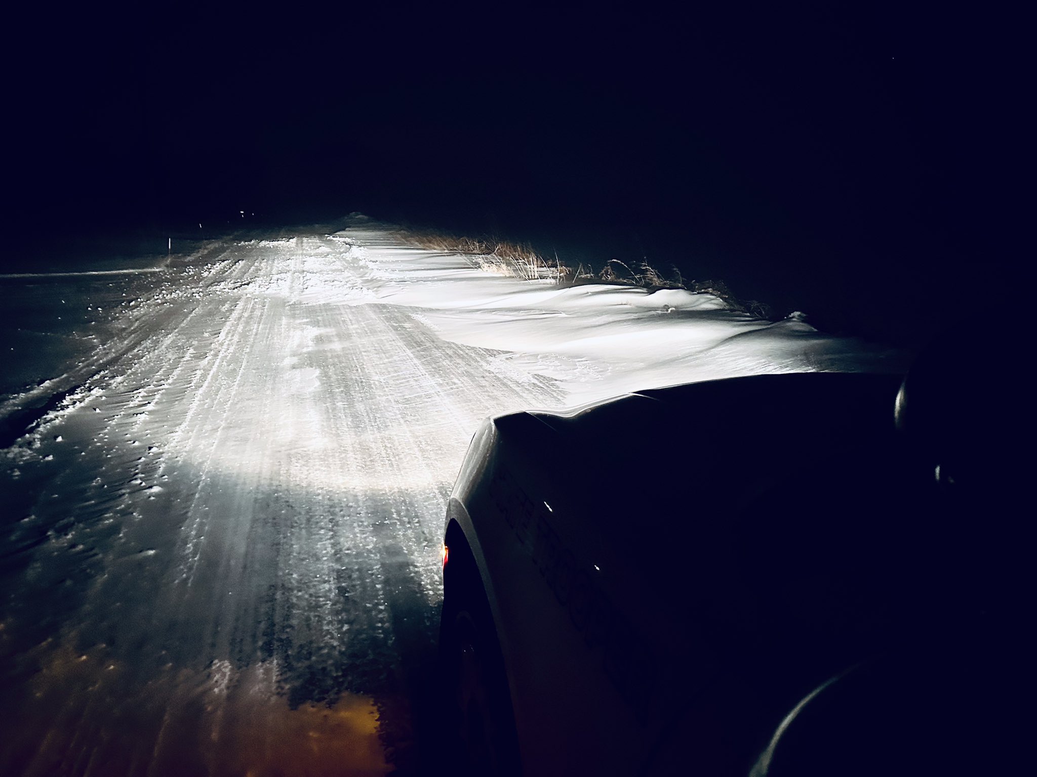
First responders braved the elements to assist with hundreds of calls. As this photo shows, drifting snow and snow-pack roads were treacherous, long after the snow stopped falling. (Ind. State Police Sgt. Ted Bohner) |
A period of heavy snow along the Arctic front resulted in these conditions in Vaughnsville, OH (Dale Otto) |
Videos
| Video of Pileup on I94 near Watervleit, MI (Aaron Rigsby) |
Whiteout at NWS IWX (Todd Holsten) |
Radar
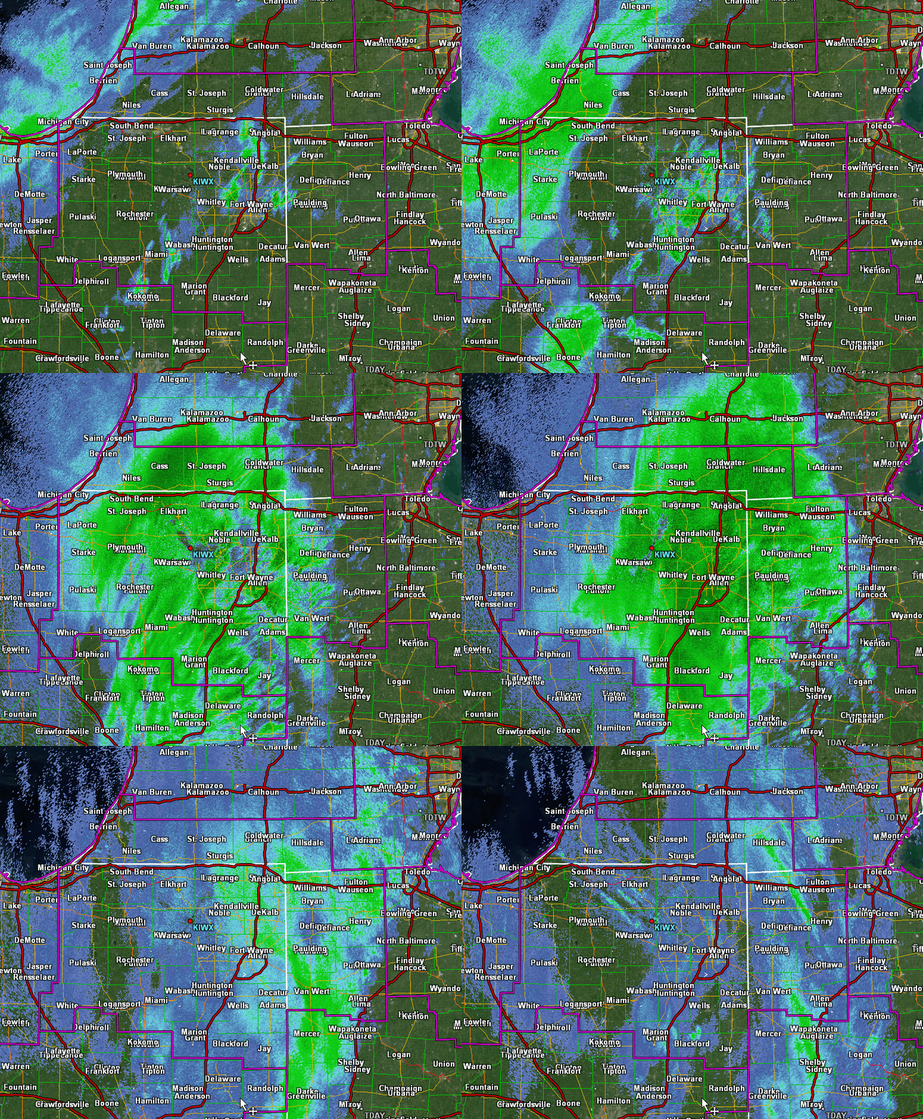 |
| KIWX Radar Loop of the Arctic Front passage |
Wind Gusts and Wind Chills
PUBLIC INFORMATION STATEMENT
NATIONAL WEATHER SERVICE NORTHERN INDIANA
431 PM EST FRI DEC 23 2022

...HIGHEST WIND REPORTS...

LOCATION                     SPEED     TIME/DATE       PROVIDER

...INDIANA...

...ALLEN COUNTY...
FORT WAYNE INTERNATIONAL AP  51 MPH    0648 AM 12/23   ASOS
2.9 S WALLEN (INDOT)         48 MPH    1029 AM 12/23   MESOWEST
SPENCERVILLE                 36 MPH    1000 AM 12/23   CWOP

...CASS COUNTY...
LOGANSPORT                   48 MPH    1035 AM 12/23   AWOS
GALVESTON                    40 MPH    0615 AM 12/23   CWOP
WALTON                       39 MPH    1215 AM 12/23   CWOP

...DE KALB COUNTY...
AUBURN DEKALB C              35 MPH    1035 AM 12/23   AWOS

...ELKHART COUNTY...
2 WNW GOSHEN                 57 MPH    1212 PM 12/23   TRAINED SPOTTER
GOSHEN                       48 MPH    0228 AM 12/23   ASOS

...GRANT COUNTY...
GAS CITY                     55 MPH    0350 AM 12/23   MESOWEST
GRANT COUNTY MUNICIPAL APT   47 MPH    0535 AM 12/23   AWOS

...HUNTINGTON COUNTY...
HUNTINGTON                   46 MPH    0328 AM 12/23   CWOP

...KOSCIUSKO COUNTY...
WARSAW MUNI                  43 MPH    0855 AM 12/23   AWOS

...MIAMI COUNTY...
GRISSOM AFB PERU             47 MPH    0933 AM 12/23   AWOS

...NOBLE COUNTY...
LIGONIER                     38 MPH    1010 AM 12/23   CWOP

...ST. JOSEPH COUNTY...
SOUTH BEND INTERNATIONAL AP  39 MPH    0115 AM 12/23   ASOS

...STEUBEN COUNTY...
ANGOLA                       38 MPH    1035 AM 12/23   AWOS

...MICHIGAN...

...BERRIEN COUNTY...
BENTON HARBOR                48 MPH    0609 AM 12/23   ASOS
2.0 W SPINKS CORNERS (MAWN)  37 MPH    1000 AM 12/23   MESOWEST

...BRANCH COUNTY...
COLDWATER                    37 MPH    0555 AM 12/23   AWOS

...HILLSDALE COUNTY...
HILLSDALE                    46 MPH    0515 AM 12/23   AWOS

...ST. JOSEPH COUNTY...
THREE RIVERS                 38 MPH    0415 AM 12/23   AWOS

...OHIO...

...ALLEN COUNTY...
LIMA                         60 MPH    0426 AM 12/23   ASOS
LIMA 1 N                     47 MPH    0757 AM 12/23   CWOP
BLUFFTON                     43 MPH    0540 AM 12/23   CWOP

...DEFIANCE COUNTY...
DEFIANCE                     47 MPH    0950 AM 12/23   ASOS

...FULTON COUNTY...
WAUSEON                      49 MPH    0915 AM 12/23   AWOS

...PUTNAM COUNTY...
OTTAWA                       51 MPH    0735 AM 12/23   AWOS
VAUGHNSVILLE                 45 MPH    0940 AM 12/23   CWOP
KALIDA                       43 MPH    1000 AM 12/23   CWOP

...VAN WERT COUNTY...
VAN WERT                     49 MPH    0910 AM 12/23   CWOP
1 ENE VAN WERT               45 MPH    1039 AM 12/23   CWOP
SCOTT                        44 MPH    0958 AM 12/23   CWOP

...INDIANA...

...MARITIME STATIONS...
2 NW MICHIGAN CITY           60 MPH    0700 AM 12/23   PUBLIC
PUBLIC INFORMATION STATEMENT
NATIONAL WEATHER SERVICE NORTHERN INDIANA
426 PM EST FRI DEC 23 2022

...24 HOUR MINIMUM WIND CHILL REPORTS ENDING 4PM EST 23 DEC 2022...

LOCATION                     WC TEMP.  TIME/DATE       PROVIDER

...INDIANA...

...ALLEN COUNTY...
FORT WAYNE INTERNATIONAL AP  -38 F     0654 AM 12/23   ASOS
2.9 S WALLEN (INDOT)         -38 F     0759 AM 12/23   MESOWEST

...CASS COUNTY...
LOGANSPORT                   -38 F     0935 AM 12/23   AWOS
GALVESTON                    -37 F     0830 AM 12/23   CWOP
WALTON                       -35 F     0616 AM 12/23   CWOP

...DE KALB COUNTY...
GARRETT                      -33 F     0930 AM 12/23   CWOP
AUBURN DEKALB C              -32 F     0835 AM 12/23   AWOS

...ELKHART COUNTY...
GOSHEN                       -37 F     0842 AM 12/23   ASOS
ELKHART MUNICIPA             -35 F     0935 AM 12/23   AWOS

...GRANT COUNTY...
GAS CITY                     -41 F     0610 AM 12/23   MESOWEST

...HUNTINGTON COUNTY...
HUNTINGTON                   -40 F     0758 AM 12/23   CWOP

...KOSCIUSKO COUNTY...
WARSAW MUNI                  -38 F     0855 AM 12/23   AWOS

...MIAMI COUNTY...
GRISSOM AFB PERU             -40 F     0847 AM 12/23   AWOS

...NOBLE COUNTY...
LIGONIER                     -34 F     0925 AM 12/23   CWOP

...ST. JOSEPH COUNTY...
SOUTH BEND INTERNATIONAL AP  -34 F     0842 AM 12/23   ASOS

...STEUBEN COUNTY...
ANGOLA                       -35 F     1035 AM 12/23   AWOS

...MICHIGAN...

...BERRIEN COUNTY...
BENTON HARBOR                -25 F     0950 AM 12/23   ASOS
2.0 W SPINKS CORNERS (MAWN)  -21 F     1000 AM 12/23   MESOWEST
4.2 S WATERVLIET (MAWN)      -18 F     0600 AM 12/23   MESOWEST

...BRANCH COUNTY...
COLDWATER                    -32 F     1015 AM 12/23   AWOS

...HILLSDALE COUNTY...
HILLSDALE                    -31 F     1035 AM 12/23   AWOS

...ST. JOSEPH COUNTY...
THREE RIVERS                 -27 F     0855 AM 12/23   AWOS
1.1 S CONSTANTINE (MAWN)     -26 F     0600 AM 12/23   MESOWEST
2.0 SE MENDON (MAWN)         -26 F     0900 AM 12/23   MESOWEST

...OHIO...

...ALLEN COUNTY...
LIMA                         -39 F     0653 AM 12/23   ASOS
LIMA 1 N                     -37 F     0847 AM 12/23   CWOP

...DEFIANCE COUNTY...
DEFIANCE                     -31 F     0924 AM 12/23   ASOS

...FULTON COUNTY...
WAUSEON                      -34 F     1015 AM 12/23   AWOS

...PUTNAM COUNTY...
OTTAWA                       -34 F     0735 AM 12/23   AWOS
OTTAWA                       -34 F     0955 AM 12/23   AWOS
VAUGHNSVILLE                 -30 F     0940 AM 12/23   CWOP
KALIDA                       -30 F     1030 AM 12/23   CWOP

...VAN WERT COUNTY...
VAN WERT                     -39 F     0750 AM 12/23   CWOP
SCOTT                        -39 F     0919 AM 12/23   CWOP
1 ENE VAN WERT               -38 F     0709 AM 12/23   CWOP

...WILLIAMS COUNTY...
BRYAN                        -33 F     0810 AM 12/23   DAVIS
Environment
A combined Atlantic and Gulf of America moisture feed (Figs. 1, 2) provided a wide breadth of low-level moisture in advance of an extremely strong upper-level jet with 150 to nearly 200 kts diving south along the Canadian to Central Rockies front (Fig. 5).
 |
 |
 |
 |
 |
|
Figure 1: Surface Plot 7 AM EST Dec 22 |
Figure 2: 925mb Plot 7 AM EST Dec 22 |
Figure 3: 850mb Plot 7 AM EST Dec 22 |
Figure 4: 500mb Plot 7 AM EST Dec 22 |
Figure 5: 250mb Plot 7 AM EST Dec 22 |
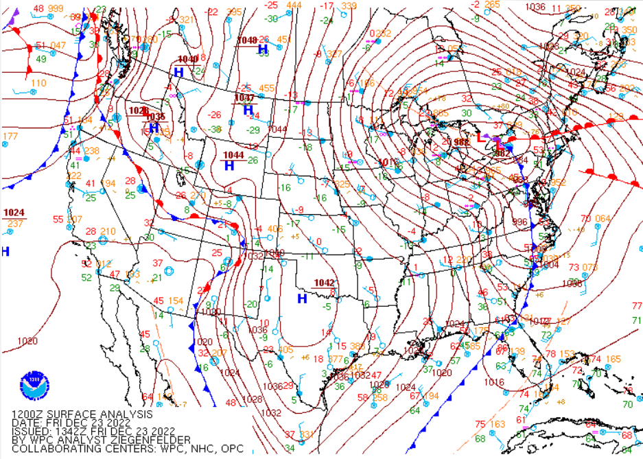
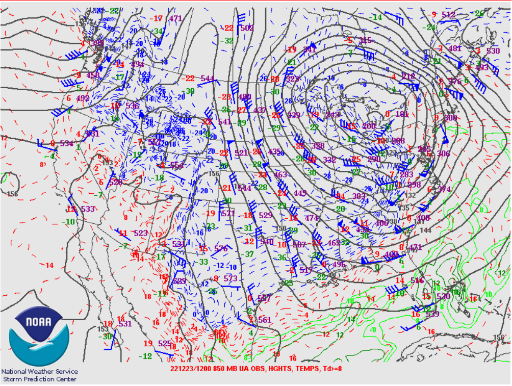
As the low-level system ramped in intensity a markedly strong arctic front swept eastward through the region late Thursday afternoon and evening, reaching western New York/central Pennsylvania (Fig. 6) at 7 AM EST Friday. The surface low underwent bombogenesis as it tracked from the Upper Great Lakes into southern Ontario, deepening an amazing 31mb in 24 hours (Figs 1, 6). A combination of rain and initially melting snow led to flash freeze conditions on roads within minutes. Temperatures plummetted 35 to 40 degrees in about 18 hours in the wake of the arctic front. As the intense upper-level jet rotated through Missouri/Tennessee (Fig. 10), rapid cyclogenetic deepening in the lower and middle troposphere (Figs. 8, 9).
 |
 |
 |
 |
 |
| Figure 6:
Surface Plot 7 AM EST Dec 23 |
Figure 7:
925mb Plot 7 AM EST Dec 23 |
Figure 8:
850mb Plot 7 AM EST Dec 23 |
Figure 9:
500mb Plot 7 AM EST Dec 23 |
Figure 10:
250mb Plot 7 AM EST Dec 23 |
Strong surface winds combined with sub-zero temperatures (Fig. 11) created potentially deadly wind chill temperatures of -30 to -41F throughout the region. Cold air over the open waters of Lake Michigan focused moderate to heavy lake effect snow over southwest Michigan into northwest Indiana. Strong winds as the cyclone continued to deepen over far western Quebec (Figs. 12, 13) produced blizzard conditions at times in the lake effect region with multi-vehicle accidents and significant holiday travel disruptions.
 |
 |
 |
 |
 |
| Figure 11:
Surface Plot 7 AM EST Dec 24 |
Figure 12:
925mb Plot 7 AM EST Dec 24 |
Figure 13:
850mb Plot 7 AM EST Dec 24 |
Figure 14:
500mb Plot 7 AM EST Dec 24 |
Figure 15:
250mb Plot 7 AM EST Dec 24 |
Climatology
On the evening of December 23, temperatures fell from the upper-30s down to about -8°F in about 18 hours. According to archived data available since the 1940s through Iowa State University, the recorded temperature drops at Fort Wayne and South Bend were records for December.
 |
 |
 |
| Figure 4: From the 22nd through the 23rd, the temperature at Fort Wayne fell from 39 to -8 in 18 hours. A 47° temperature drop. (Courtesy of Iowa State University) | Figure 5: From the 22nd through the 23rd, the temperature at South Bend fell from 37 to -8 in 18 hours. A 45° temperature drop. (Courtesy of Iowa State University) | Figure 6: Outside of December, this was still a noteworthy temperature drop. Dating back to 1948, this storm's extreme temperature swing is rivaled by only four other events. (Courtesy of Iowa State University) |
 |
 |
 |
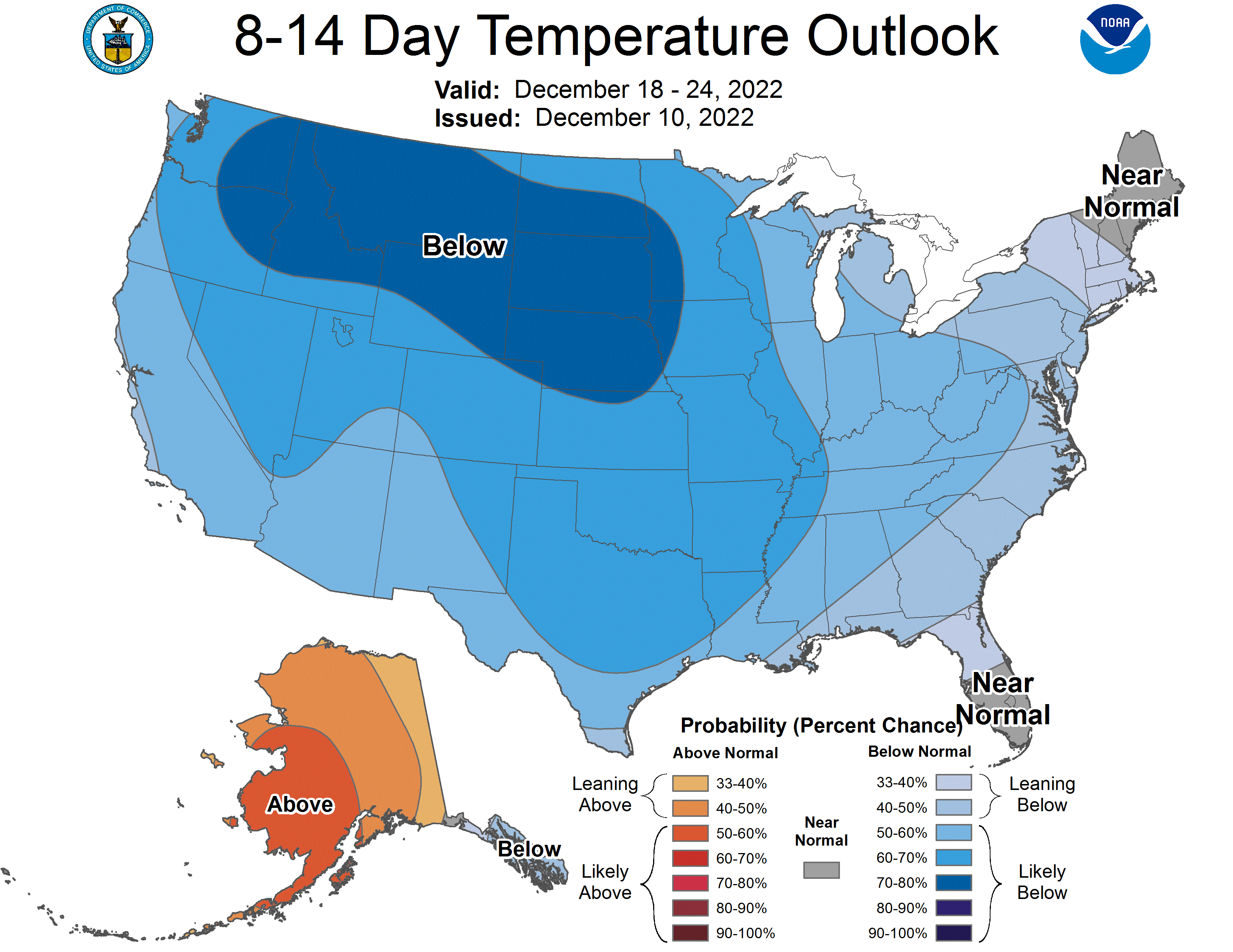
| Figure 7: The 8-14 day outlooks from the Climate Prediction Center indicated there was high confidence that below normal temperatures were favored all the way back on December 10 when the above outlook was released. | Figure 8: A few days later, the updated outlook from the CPC showed an impressive 90-100% probability of below normal temperatures toward the end of December. | Figure 9: Temperatures were indeed well below normal, with highs in the single-digits and lows below zero on the 23rd. When strong westerly winds were factored in, wind chills were dangerous cold on the morning of the 23rd (shown). |
Additional Climate Facts:
Christmas Eve and Christmas Day Climatology:
Climate data is available beginning in 1893 at South Bend, and 1897 at Fort Wayne.
Was This A Blizzard?
Much discussion has taken place on the reasons why our area experienced at least a short period of blizzard or blizzard-like conditions, yet most were under Winter Storm Warnings versus a Blizzard Warning. Here is a breakdown of the thought process that went into the warning decision.
Definition of a Blizzard
To start off, we have to define what a Blizzard is. The following conditions must be met for 3 consecutive hours or more...
Note that snow does NOT have to be falling as part of the criteria for a blizzard. When these conditions are met without falling snowfall, it is referred to as a Ground Blizzard" It is not uncommon for what is considered "near-blizzard" or "blizzard-like" conditions to occur during a winter storm.
Warning Decision Thought Process
Knowing the difficulties in reaching true blizzard conditions, the forecasters look at where the greatest chance of the criteria being met exists. Confidence was high that the wind speed criteria would be met across the entire area. Confidence was not as high as to the duration of the lower visibilities. In this case, far northwestern parts of our area near Lake Michigan posed the greatest chance of meeting the criteria as both the winds and expected falling snow from the lake effect snow would combine to bring a likely period of criteria being met.
As was stressed through our forecast discussions, social media posts and numerous interviews prior to and during the storm, many areas would see one or more periods of near-blizzard or blizzard-like conditions and this did occur. The key comes down to the duration of time and that it occurs in a consecutive period. Often times we are only able to use the data from automated weather stations (ASOS or AWOS) that measure visibility, as well as those that understand how you determine what the visibility is AND observe it long enough to ensure the duration of these conditions is met. It is this element that is the most difficult to sort out and given the uncommon occurrences of true blizzard conditions around here, we want to ensure that the use of a Blizzard warning is reserved for the most potentially life-threatening setup.
Verification
A total of 6 counties were under a Blizzard Warning. While the verification process is still underway, we have already determined that the counties of Berrien and Cass n Michigan and LaPorte and St Joseph in Indiana met the criteria. These areas not only had persistent strong winds for many hours, but also maintained less than 1/4 mile visibility for not only 3 consecutive hours, but in terms of the Benton Harbor and South Bend airports, these conditions lasted for over 24 hours with little or no relief. Allen county, IN, and more specifically Fort Wayne airport, had a 3-hour period between during the afternoon hours of Dec 23 when the visibility was frequently below 1/4 mile. In addition, there is a weather contract observer there 24 hours a day monitoring conditions.
Regardless of whether a "blizzard" occurred or not, the combination of strong winds, dangerous wind chills, and poor road conditions was, by far, the greatest focus for the area.
 |
Media use of NWS Web News Stories is encouraged! Please acknowledge the NWS as the source of any news information accessed from this site. |
 |