Overview
LAST UPDATE 12 PM EDT 5/20/17
A cold front brought isolated severe weather to the forecast area on May 18, 2017. Reports of wind damage were prevalent, along with several reports of flooding and smaller hail. Mammatus clouds were observed by many across the area just prior to sunset.
Wind
A majority of the reports received with this event were due to straight line winds. Here are photos submitted to us of the damage. For select radar images of the wind signatures, see our "Radar" section.
Wind Damage in the Haviland, Oh area
Two swaths of wind damage were noted from separate thunderstorms west of Haviland. The first storm snapped a couple dozen power poles near the ground from northwest of Haviland to west of Haviland along County Road 107. A few smaller tree limbs were also blown down. Around 625 pm EDT, A second swath caused significant damage to a large pole barn southwest of the intersection of State Route 114 and County Road 87. Debris was carried to the southeast for roughly 2 miles across open fields. Several power poles were also snapped towards the end of the downburst. Along County Road 107, between 70 and 80 power poles were snapped by strong winds. Winds are estimated at between 80 to 85 mph.
Wind Damage East of Cecil, OH
Damage was found along a roughly one mile path of isolated damage starting near the intersection of County Road 224 and 133. At around 429 pm EDT, an older pole barn was impacted by the winds, causing it fall onto itself and mainly roofing debris being carried roughly a third of a mile. Several 2 by 4 boards were found embedded in the ground in various directions. Along this same path a garage door was pushed in with a few pieces of roofing thrown east to northwest of the
intersection of County Roads 224 and 139. A 5th wheel trailer was rolled several times, landing in a pond. Near the intersection of County Roads 218 and
133, 2 garage doors were pushed in. One of the buildings had its north and south walls pushed outward.
While the boards in the ground near the pole barn, as well as damage to structures south of the destroyed barn may suggest some weak rotation, damage in the area was not conclusive enough to classify a small area of damage as possibly tornadic. Data will continue to be reviewed.
 |
 |
 |
 |
| Storm Damage near Cecil, OH (Courtesy of Rick McCoy, Van Wert EMA) | Storm Damage near Cecil, OH (Courtesy of Rick McCoy, Van Wert EMA) | Storm Damage near Cecil, OH (Courtesy of Rick McCoy, Van Wert EMA) | Storm Damage near Cecil, OH (Courtesy of Rick McCoy, Van Wert EMA) |
 |
 |
 |
 |
| Storm Damage near Cecil, OH (Courtesy of Rick McCoy, Van Wert EMA) | Storm Damage near Cecil, OH (Courtesy of Rick McCoy, Van Wert EMA) | Damage near Cecil, OH (Courtesy of Rick McCoy, Van Wert EMA) | Storm Damage near Cecil, OH (Courtesy of Rick McCoy, Van Wert EMA) |
 |
 |
 |
 |
| Storm Damage near Cecil, OH (Courtesy of Rick McCoy, Van Wert EMA) | Storm Damage near Cecil, OH (Courtesy of Rick McCoy, Van Wert EMA) | Storm Damage near Cecil, OH (Courtesy of Rick McCoy, Van Wert EMA) | Storm Damage near Cecil, OH (Courtesy of Rick McCoy, Van Wert EMA) |
Flooding
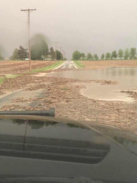
The storms were pretty efficient rain producers, causing rain rates of up to 1-2 inches per hour. Additionally, the storms moved over the same area repeatedly for a long portion of the evening, which led to flooding-particularly in Huntington County, IN. Allen county, IN was also under a flood warning, but reports of flooding were not sent to us as of 5/19 at 4 AM EDT.
Flooding Photos/Video
 |
 |
 |
| Tony Ehler near (Huntington, IN EMA) Meridian Road near 900 N | Tony Ehler near (Huntington, IN EMA) near 900 N | Tony Ehler near (Huntington, IN EMA) 1000N between Seminary Rd & Roanoke Rd |
Mammatus Clouds
One unusual sight observed near sunset in several parts of the forecast area were the Mammatus clouds. We even saw them here at IWX. Thanks to those who submitted these beautiful photos.
Mammatus results from the sinking of moist air into dry air. It is in essence an upside down cloud. The sharp bounday of mammatus is much like the sharp boundary of a rising cumulonimbus cloud before an anvil has formed. Mammatus typically develop on the underside of a thunderstorm's anvil and can be a remarkable sight, especially when sunlight is reflected off of them.
 |
 |
 |
 |
| Kyler Welden |
Logan Gonya (Angola, IN) |
Mark Hawley | Mark Hawley |
 |
 |
 |
 |
| Twitter User "HippyPokerGuy" | Jim Merin | Megan Dodson (NWS IWX) | Megan Dodson (NWS IWX) |
 |
 |
 |
 |
| Megan Dodson (NWS IWX) | Tom Coomes ABC 57 | Twitter User "CoachJen" |
Twitter User "CoachJen" |
Radar:
Winds
 |
 |
 |
 |
| Reflectivity (Z) Near Cecil/Paulding, OH: 4:26 PM EDT | Velocity (V) Near Cecil/Paulding, OH: 4:26 PM EDT | Storm Relative Velocity (SRV) Near Cecil/Paulding, OH: 4:26 PM EDT | Correlation Coefficient (CC) near Cecil/Paulding, OH: 4:26 PM ET |
 |
 |
 |
 |
| Reflectivity (Z) Near Cecil/Paulding, OH: 4:29 PM EDT | Velocity (V) Near Cecil/Paulding, OH: 4:29 PM EDT | Storm Relative Velocity (SRV) Near Cecil/Paulding, OH: 4:29 PM EDT | NROT near Cecil/Paulding, OH: 4:29 PM EDT |
 |
 |
 |
 |
| Reflectivity (Z) Near Cecil/Paulding, OH: 4:34 PM EDT | Velocity (V) Near Cecil/Paulding, OH: 4:34 PM EDT | Storm Relative Velocity (SRV) Near Cecil/Paulding, OH: 4:34 PM EDT | Correlation Coefficient (CC) near Cecil/Paulding, OH: 4:34 PM ET |
 |
 |
 |
 |
| Reflectivity (Z) Near Payne, OH at 5 pm EDT | Velocity (V) Near Payne, OH at 5 pm EDT | Vertical Cross Section of Reflectivity (Z) Near Payne, OH at 5 pm EDT | Correlation Coefficient (CC) near Payne, OH: 5 PM EDT |
Storm Reports
LSRIWX

PRELIMINARY LOCAL STORM REPORT...SUMMARY
NATIONAL WEATHER SERVICE NORTHERN INDIANA
931 PM EDT THU MAY 18 2017

..TIME...   ...EVENT...      ...CITY LOCATION...     ...LAT.LON...
..DATE...   ....MAG....      ..COUNTY LOCATION..ST.. ...SOURCE....
            ..REMARKS..

0910 PM     HEAVY RAIN       4 NE NINE MILE          41.02N 85.18W
05/18/2017  M1.56 INCH       ALLEN              IN   MESONET

            MESONET STATION E9914, 3 NE NINE MILE.

0905 PM     HEAVY RAIN       4 NNW HUNTINGTON        40.93N 85.55W
05/18/2017  M1.31 INCH       HUNTINGTON         IN   MESONET

            MESONET STATION AT649, 3 NW HUNTINGTON.

0903 PM     HEAVY RAIN       1 W ROLLING HILLS       41.03N 85.29W
05/18/2017  M0.85 INCH       ALLEN              IN   MESONET

            MESONET STATION E6631, ROLLING HILLS.

0903 PM     HEAVY RAIN       3 SW CHARLOE            41.10N 84.48W
05/18/2017  M0.76 INCH       PAULDING           OH   MESONET

            MESONET STATION D4262, 3 SW CHARLOE.

0902 PM     HEAVY RAIN       LEIPSIC                 41.10N 83.99W
05/18/2017  M0.79 INCH       PUTNAM             OH   MESONET

            MESONET STATION E0171, LEIPSIC.

0850 PM     FLOOD            3 ESE GOBLESVILLE       40.98N 85.45W
05/18/2017                   HUNTINGTON         IN   PUBLIC

            WATER OVER MERIDIAN ROAD, NORTH OF 900 N.

0830 PM     FLOOD            1 WSW ROANOKE           40.96N 85.38W
05/18/2017                   HUNTINGTON         IN   PUBLIC

            WATER OVER THE ROAD- 900N.

0825 PM     FLOOD            1 NNW ROANOKE           40.97N 85.38W
05/18/2017                   HUNTINGTON         IN   EMERGENCY MNGR

            WATER OVER THE ROAD-1000N BETWEEN SEMINARY
            RD & ROANOKE RD.

0757 PM     TSTM WND DMG     1 WSW PERU              40.75N 86.09W
05/18/2017                   MIAMI              IN   EMERGENCY MNGR

            REPORTS OF SEVERAL TREES DOWN AROUND THE
            PERU, IN AREA-AND SEVERAL LIGHTNING STRIKES.
            WINDS ESTIMATED AT ABOUT 50 MPH.
            APPROXIMATELY 1" OF RAIN WAS MEASURED AS
            WELL.

0746 PM     TSTM WND GST     2 NE NINE MILE          41.00N 85.20W
05/18/2017  M53 MPH          ALLEN              IN   ASOS


0739 PM     HEAVY RAIN       4 NNW HUNTINGTON        40.93N 85.55W
05/18/2017  M0.93 INCH       HUNTINGTON         IN   MESONET

            MESONET STATION AT649, 3 NW HUNTINGTON.

0732 PM     TSTM WND DMG     3 SE GOBLESVILLE        40.96N 85.47W
05/18/2017                   HUNTINGTON         IN   EMERGENCY MNGR

            HEALTHY 2-3" LIMB DOWNED AT INTERSECTION OF
            SR9 AND 900 N.

0724 PM     TSTM WND DMG     1 W ADAMSBORO           40.79N 86.29W
05/18/2017                   CASS               IN   EMERGENCY MNGR

            A COUPLE OF TREES REPORTED ON HOUSES, NEAR
            INTERSECTION OF CR 150 N AND CR 450 E.
            NUMEROUS TREES REPORTED DOWN IN THE NEARBY
            WOODED AREA.

0715 PM     TSTM WND GST     OTTAWA                  41.02N 84.04W
05/18/2017  M48 MPH          PUTNAM             OH   AWOS


0623 PM     TSTM WND DMG     2 N CONVOY              40.95N 84.71W
05/18/2017                   VAN WERT           OH   EMERGENCY MNGR

            SHINGLES BLOWN OFF OF A HOUSE ROOF.

0620 PM     HEAVY RAIN       AKRON                   41.04N 86.02W
05/18/2017  M1.03 INCH       FULTON             IN   TRAINED SPOTTER

            30 MINUTE STORM TOTAL PRECIPITATION.

0600 PM     TSTM WND DMG     1 ESE BEAVER DAM LAKE   41.09N 85.96W
05/18/2017                   KOSCIUSKO          IN   911 CALL CENTER

            REPORTS OF A TREE DOWN ON S 675 W BETWEEN
            BEAVER DAM AND SILVER LAKE, IN.

0542 PM     TSTM WND GST     2 ENE NINE MILE         40.99N 85.19W
05/18/2017  M56 MPH          ALLEN              IN   ASOS


0525 PM     TSTM WND DMG     4 E CECIL               41.22N 84.52W
05/18/2017                   PAULDING           OH   EMERGENCY MNGR

            EM CALLED TO REPORT DAMAGE FROM THE
            CECIL/EMERALD TOWNSHIP AREA. THERE WERE
            REPORTS OF SEVERAL TREES DOWNED, 3-4 POWER
            LINES DOWNED, A TRAMPOLINE WAS BLOWN OUT
            INTO THE ROAD. THIS WAS NEAR SR 111N AND CR
            133. THEN NEAR CR 138 & CR 178 THE EMERALD
            TOWNSHIP BUILDING ROOF WAS PARTIALLY BLOWN
            OFF INTO THE WOODS. REPORTS OF WOOD STICKING
            OUT FROM THE GROUND, 2 FLATTENED BARNS, AND
            A HOUSE TO THE SOUTH OF EMERALD TOWNSHIP
            BUILDING THAT HAS A HOUSE LEANING ON IT.
            THERE WERE REPORTS OF A CAMPER THAT WAS
            THROWN INTO A POND ON CR 133. NO REPORTS OF
            INJURIES OR FATALITIES AT THIS TIME.

0515 PM     TSTM WND DMG     1 ESE DESHLER           41.20N 83.89W
05/18/2017                   HENRY              OH   PUBLIC

            TRAMPOLINE TOSSED INTO A TRAILER, CAUSING
            MINOR DAMAGE TO THE TRAILER. TRAMPOLINE WAS
            TIED DOWN.

0511 PM     TSTM WND DMG     1 NE BRICETON           41.10N 84.62W
05/18/2017                   PAULDING           OH   EMERGENCY MNGR

            18 POWER POLES DOWNED ALONG CR 95.

0505 PM     TSTM WND DMG     PAYNE                   41.08N 84.73W
05/18/2017                   PAULDING           OH   TRAINED SPOTTER

            DOWNED TREES OF ABOUT 1-2 FT DIAMETER. POWER
            LINES DOWNED FROM TREES ON THE CORNER OF
            GIBSON AND MERRIN STREET IN PAYNE, OH.

0505 PM     TSTM WND GST     PAYNE                   41.08N 84.73W
05/18/2017  E60 MPH          PAULDING           OH   TRAINED SPOTTER

            ALSO OBSERVED PEA SIZED HAIL.

0436 PM     TSTM WND DMG     GILEAD                  40.97N 86.02W
05/18/2017                   MIAMI              IN   EMERGENCY MNGR

            REPORTS OF TREES DOWN ON SR 19. ALSO REPORTS
            OF TREES DOWNED ON MACY-GILEAD RD. TREES
            LOOK HEALTHY, ONE IS 3 FT IN DIAMETER, THE
            OTHERS AROUND 1-2 FT IN DIAMETER.

0429 PM     TSTM WND DMG     4 E CECIL               41.22N 84.52W
05/18/2017                   PAULDING           OH   EMERGENCY MNGR

            OLD WOODEN BUILDINGS WERE KNOCKED DOWN,
            WALLS BLOWN OUTWARD AND DOORS BLOWN OFF.
            DEBRIS CARRIED ABOUT 1/4 MILE TO THE
            SOUTHEAST.

0429 PM     TSTM WND DMG     4 S THE BEND            41.22N 84.52W
05/18/2017                   PAULDING           OH   EMERGENCY MNGR

            NEAR INTERSECTION OF CR 133 AND C-224, BARN
            BLOWN APART, DEBRIS SCATTERED FOR ABOUT 1/2
            A MILE INTO THE WOODS TO THE NE. SOME OF THE
            DEBRIS WAS SHOT INTO THE GROUND.
Environment
Storms developed in a subtle confluence zone ahead of the cold front, in a pre-frontal trough. This provided the "lift" or "trigger" for the storms.
 |
 |
 |
 |
|
Figure 1: 10 AM EDT Surface Map (WPC) |
Figure 2: 2 PM EDT Surface Map (WPC) | Figure 3: 5 PM EDT Surface Map (WPC) | Figure 4. 8 PM EDT Surface Map (WPC) |
 |
Media use of NWS Web News Stories is encouraged! Please acknowledge the NWS as the source of any news information accessed from this site. |
 |