Overview
We're off to a snowy start for December, with several events impacting the Great Lakes region recently. This page review focuses on the system snow we received December 10th-December 12th, but will also give a short summary of the lake effect snow we got December 8-9th.
Click one of these tabs to view more information on each topic.
Snow
Below are the storm-total snowfall maps depicting the snow reports we've received via our CoCoRaHs observers and CO-OP observers. Keep in mind these are approximations based on 48 hour totals, data may not be complete in all areas. If you would like to see specific reports for various locations, click on the "storm reports" tab. Some areas received minor amounts of freezing drizzle/sleet the afternoon/evening of the 11th, which led to icy road conditions.
 |
 |
| Winter Storm Totals December 10-12th, 2016. Note: Bulls eye over Plymouth, IN is incorrect. Should be around 5-6 inches. (CoCoRaHs/COOP Observers ONLY) |
Lake Effect Storm Totals December 8-9, 2016 (CoCoRaHs/COOP Observers ONLY) |
Quick Facts for the Winter Storm December 10-12th
36-48 hr Storm Totals (in)
South Bend, IN: 8.0
Fort Wayne, IN: 7.5 (6.3" fell on Dec 11th, breaking the previous record of 2.4" in 1944)
Highest Reports: 10.2 in St. Joseph, MI (Berrien County, Trained Spotter) and 11.3 in Hillsdale, MI (Hillsdale, MI COOP).
Storm Reports
Winter Storm December 10-12th, 2016

Public Information Statement
National Weather Service Northern Indiana
1009 PM EST Mon Dec 12 2016

...Storm Total Snowfall Reports December 10-12th 2016...

Note: Some of these totals include snowfall from lake effect snow this
weekend, but most of the snow is from the winter storm starting the evening
of December 10th and continuing into the morning of December 12th.

Location                     Amount    Time/Date       STATION ID OR LAT/LON

...Indiana...

...Adams County...
1N Decatur                    3.5 in    0830 AM 12/12       DCRI3
Berne WWTP                    1.5 in    0800 AM 12/12       BERI3

...Allen County...
Fort Wayne Airport          7.5 in    0700 AM 12/12        FWAI3
2NNW Leo-Cedarville         7.4 in    0800 AM 12/12       IN-AL-36
3WSW Woodburn               6.9 in    0700 AM 12/12       IN-AL-32
6N   Fort Wayne             6.8 in    0800 AM 12/12       IN-AL-53
3ESE Huntertown             6.5 in    0900 AM 12/12       IN-AL-5
9SE Fort Wayne              6.3 in    0800 AM 12/12       IN-AL-7
3NE  Fort Wayne             6.3 in    0730 AM 12/12       IN-AL-51
1NNW Fort Wayne             6.2 in    0600 AM 12/12       IN-AL-37
7WSW Fort Wayne             5.7 in    0800 AM 12/12       IN-AL-42

...Blackford County...
1N Hartford City            1.6 in    0700 AM 12/12       IN-BL-11
5NW Hartford City           2.7 in    0700 AM 12/12       IN-BL-7

...Cass County...
2NNW Logansport             4.0 in    0800 AM 12/12       IN-CS-7

...DeKalb County...
1NE Auburn                  6.0 in    0600 AM 12/12       IN-DK-5

...Elkhart County...
3SW Simonton Lake           9.0 in    1000 PM 12/11     41.72N/86.01W
3WSW Goshen                 8.2 in    0700 AM 12/12       IN-EL-39
3NNE Osceola                8.0 in    0630 PM 12/11     41.71N/86.06W
4SSW Bristol                7.2 in    0630 PM 12/11     41.67N/85.85W
Millersburg                 6.9 in    0800 AM 12/12       IN-EL-7
2NNE Wakarusa               6.2 in    0700 AM 12/12       IN-EL-8
5SW Elkhart                 6.0 in    0500 AM 12/12       IN-EL-36
1SW Goshen                  5.9 in    0630 AM 12/12       IN-EL-59
Elkhart Public Works        5.0 in    1200 AM 12/12        EKMI3

...Fulton County...
Rochester                   7.0 in    0700 AM 12/12        RCRI3
2NW Rochester               6.7 in    0700 AM 12/12       IN-FL-3
Akron                       6.0 in    0215 PM 12/11     41.04N/86.03W

...Grant County...
2N Marion                   3.3 in    0700 AM 12/12        MZZI3
2SSE Upland                 1.5 in    0700 AM 12/12       IN-GR-18

...Huntington County...
Huntington                  5.8 in    0700 AM 12/12       IN-HT-1
Huntington COOP             5.5 in    0800 AM 12/12        HNTI3

...Jay County...
2S Portland                 1.4 in    0700 AM 12/11       IN-JY-12

...Kosciusko County...
7SE Leesburg                8.5 in    0700 AM 12/12       IN-KS-32
2NW Tippecanoe Lake         7.8 in    1130 PM 12/11     41.34N/85.78W
2N North Webster-IWX        7.6 in    0700 AM 12/12    NWS OBSERVATION
Leesburg                    7.5 in    0600 AM 12/12       IN-KS-11
1NNW Winona Lake            7.0 in    0200 PM 12/11     41.23N/85.82W
1E Claypool                 6.5 in    0600 AM 12/12       IN-KS-22
5SW Warsaw                  6.4 in    0800 AM 12/12        WARI3
1NNW Sechrist Lake          6.0 in    0200 PM 12/11     41.30N/85.72W
1N Warsaw                   5.9 in    0600 AM 12/12       IN-KS-51
3ESE Syracuse               4.7 in    0900 AM 12/12       IN-KS-7

...LaGrange County...
1ENE LaGrange               6.8 in    0400 PM 12/12       IN-LG-5

...LaPorte County...
LaPorte                     9.0 in    0845 AM 12/12        LAPI3
7WNW New Carlisle           7.0 in    0430 AM 12/12       IN-LP-54
2SW Laporte                 6.6 in    0700 AM 12/12       IN-LP-7
1E  Hanna                   6.4 in    0700 AM 12/12       IN-LP-53
4ESE Wanatah                4.6 in    0800 AM 12/12       IN-LP-2
Kingsbury                   5.0 in    0700 AM 12/12       IN-LP-9
2WNW Wanatah                5.0 in    0700 AM 12/12        WANI3

...Marshall County...
1N Twin Lakes               5.3 in    0400 AM 12/12     41.33N/86.36W
Plymouth                    5.2 in    0600 AM 12/12     41.35N/86.31W

...Miami County...
1NE Denver                  5.7 in    0700 AM 12/12       IN-MM-4
Peru                        6.0 in    0830 AM 12/12        PERI3
2W Stockdale                5.0 in    1230 PM 12/11     40.91N/85.98W
Mexico                      5.0 in    0145 PM 12/11     40.81N/86.11W

...Noble County...
5NW Kendallville            8.0 in    0700 AM 12/12       IN-NB-24
2E Rome City                8.0 in    0845 AM 12/12     41.48N/85.31W
2E Etna                     7.9 in    0700 AM 12/12       IN-NB-23
Kendallville                7.7 in    0700 AM 12/12        KDVI3

...Pulaski County...
5N Medaryville              5.6 in    0800 AM 12/12        MNSI3
Francesville                4.5 in    0800 AM 12/12        FRCI3

...St. Joseph County...
South Bend Official         8.0 in    0700 AM 12/12        SBSI3
2ENE Granger                8.0 in    0700 AM 12/12       IN-SJ-46
5SE South Bend              7.9 in    0700 AM 12/12       IN-SJ-28
4ENE Mishawaka              7.8 in    0740 AM 12/12       IN-SJ-26
4NE South Bend              7.7 in    0700 AM 12/12       IN-SJ-62
3W Granger                  7.0 in    0700 AM 12/12       IN-SJ-16
6ENE Walkerton              7.0 in    0800 AM 12/12       IN-SJ-17

...Starke County...
1SSW North Judson           6.0 in    0730 AM 12/12       IN-ST-9
1E Salem Center             5.8 in    0630 AM 12/12    41.59N/85.11W
Knox WWTP                   5.5 in    0700 AM 12/12        KNXI3

...Steuben County...
Angola                      8.7 in    0700 AM 12/12        ANQI3
4N Angola                   8.0 in    0615 AM 12/12       IN-SN-9
2NE Crooked Lake            8.0 in    0840 AM 12/12    41.70N/85.00W
4NNW Hudson                 7.3 in    0600 AM 12/12       IN-SN-2
5N Hudson                   6.2 in    0800 AM 12/12       IN-SN-3
2E Hamilton                 6.0 in    0700 AM 12/12       IN-SN-5

...Wabash County...
North Manchester            7.0 in    0430 PM 12/11     41.00N/85.77W
Wabash                      4.0 in    0600 AM 12/12       IN-WB-18

...Wells County...
6N Bluffton            4.6 in    0800 AM 12/12             BLRI3

...White County...
1NNE Monticello             4.9 in    0600 AM 12/12       IN-WH-18
1WSW  Indiana Beach         4.0 in    0520 PM 12/11     40.79N/86.79W
5W Chalmers                 3.3 in    0600 AM 12/12        CHRI3

...Whitley County...
5S Columbia City            6.3 in    0600 AM 12/12       IN-WY-17

...Michigan...

...Berrien County...
St. Joseph                 10.2 in    0700 AM 12/12      42.10N/86.49W
1ESE Buchanan               9.8 in    0700 AM 12/12        MI-BN-3
Fair Plain                  9.0 in    1150 PM 12/11      42.08N/86.45W
2SSE Stevensville           8.9 in    0700 AM 12/12        MI-BN-2

...Branch County...
2SW Union City              8.5 in    0530 PM 12/12     42.05N/85.17W
Coldwater                   6.0 in    1200 AM 12/12     41.94N/85.00W

...Cass County...
5NNW Dowagiac               8.6 in    0800 AM 12/12        MI-CS-2
3NW Edwardsburg             7.7 in    0800 AM 12/12        MI-CS-5

...Hillsdale County...
Hillsdale                  11.3 in    0800 AM 12/12         HILM4
1NE Moscow                  9.0 in    1200 AM 12/12     42.06N/84.50W
Litchfield                  8.7 in    0630 AM 12/12        MI-HL-1
2SSE Montgomery             8.9 in    0800 AM 12/12        MI-HL-9
6ENE Jonesville             6.0 in    0800 AM 12/12        MI-HL-4

...St. Joseph County...
St. Joseph                  8.0 in    1050 AM 12/12        MI-SJ-4

...Ohio...

...Allen County...
3NE Lima                   2.8 in     0700 AM 12/12        OH-AL-5

...Defiance County...
1E Defiance                8.0 in     0800 AM 12/12        OH-DF-1
Hicksville                 7.0 in     0500 AM 12/12         HICO1

...Fulton County...
2NW Tedrow                 9.0 in     0545 PM 12/11      41.63N/84.24W
Wauseon WWTP               7.0 in     0800 AM 12/12         WAUO1

...Henry County...
1WSW Napoleon              6.7 in     0800 AM 12/12        OH-HY-7
5NNW Napoleon              7.3 in     0700 AM 12/12        OH-HY-9
3SSE McClure               6.6 in     0700 AM 12/12        OH-HY-5

...Paulding County...
Paulding                   5.0 in     0700 AM 12/12         PAUO1
Grover Hill                3.0 in     0700 AM 12/12         GRHO1

...Putnam County...
No reports received

...Williams County...
Bryan                      6.0 in     1000 PM 12/11      41.74N/84.55W


...Van Wert County...
Van Wert                   4.0 in     1130 AM 12/12           EMA
Convoy                     3.5 in     1130 AM 12/12           EMA

Observations are collected from a variety of sources with varying
equipment and exposures. Not all data listed are considered official.

$$

NWS Northern Indiana
IRIS System
Lake Effect Snow December 8-9th, 2016
Public Information Statement
National Weather Service Northern Indiana
415 PM EST Fri Dec 9 2016

...24 Hour Snowfall Reports...

Location                     Amount    Time/Date       Lat/Lon

...Indiana...

...Elkhart County...
1 WNW Jimtown                0.5 in    0800 AM 12/09   41.64N/86.04W

...St. Joseph County...
South Bend International Ap  2.8 in    0654 AM 12/09   41.71N/86.32W
South Bend                   2.8 in    0814 AM 12/09   41.68N/86.27W
1 ENE Georgetown             2.5 in    0700 AM 12/09   41.74N/86.19W
1 E Indian Village           2.5 in    0900 AM 12/09   41.71N/86.21W
1 ENE Gulivoire Park         1.2 in    0600 AM 12/09   41.62N/86.22W
1 ENE Granger                1.2 in    0700 AM 12/09   41.75N/86.11W
1 NW Osceola                 1.0 in    0730 AM 12/09   41.68N/86.10W
2 N Teegarden                0.5 in    0700 AM 12/09   41.50N/86.39W

...Steuben County...
Angola                       0.7 in    0700 AM 12/09   41.64N/84.99W

...Michigan...

...Berrien County...
Niles                        3.5 in    0810 AM 12/09   41.83N/86.25W
1 W Fair Plain               2.1 in    0700 AM 12/09   42.08N/86.48W
1 ESE Buchanan               1.8 in    0700 AM 12/09   41.82N/86.34W
2 W Niles                    1.7 in    0800 AM 12/09   41.84N/86.30W
Niles                        1.4 in    0330 PM 12/09   41.84N/86.27W

...Cass County...
Cassopolis                   5.0 in    1154 AM 12/09   41.91N/86.01W
1 ESE Magician Lake          3.8 in    0845 AM 12/09   42.06N/86.14W
1 SSE Sandy Beach            3.8 in    1114 AM 12/09   42.03N/86.18W

...Hillsdale County...
Litchfield                   2.2 in    0630 AM 12/09   42.05N/84.75W
Hillsdale                    1.8 in    0800 AM 12/09   41.94N/84.64W

...St. Joseph County...
Three Rivers                 1.8 in    0700 AM 12/09   41.93N/85.63W

Observations are collected from a variety of sources with varying
equipment and exposures. Not all data listed are considered official.

$$
Environment
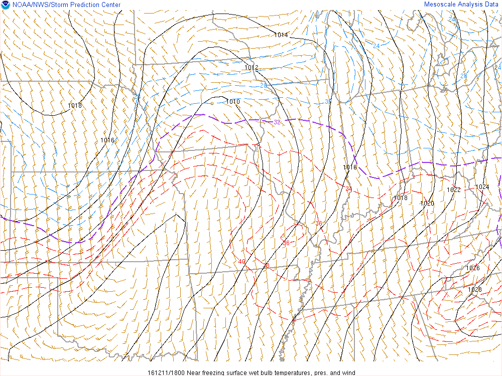
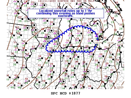
On December 11th, a surface low pressure system drifted east-northeast from Iowa, gradually lifting a warm front into our forecast area by the afternoon hours (Fig. 1). Through the night, the low lifted into Michigan, eventually bringing a cold front through the region on the 12th (Figures 2 and 3). Figures 4-6 show the wet bulb temperature near the surface. This is often a better representation of where the rain/snow line may exist. Notice how it works north with the warm front and then shifts east with the cold front. The Storm Prediction Center highlighted parts of our area during the event for heavy snowfall (Fig 7 and 8).
 |
 |
 |
| Figure 1: Surface Low/Warm Front 1 pm EST 12/11/16 |
Figure 2: Surface Low Pressure 10 pm EST 12/11/16 |
Figure 3: Surface low/Cold front 4 am EST 12/12/16 |
Rain/Snow Line Progress (Dark Dashed Line is Freezing)
 |
 |
 |
| Figure 4: Surface Wet Bulb Temperature 1 pm EST 12/11/16 |
Figure 5: Surface Wet Bulb Temperature 10 pm EST 12/11/16 |
Figure 6: Surface Wet Bulb Temperature 4 am EST 12/12/16 |
Mesoscale Outlooks (From the Storm Prediction Center)
 |
 |
| Figure 7: Heavy Snow Discussion 759 PM EST Sat Dec 10 |
Figure 8: Heavy Snow Discussion 642 PM EST Sun Dec 11 |
 |
Media use of NWS Web News Stories is encouraged! Please acknowledge the NWS as the source of any news information accessed from this site. |
 |