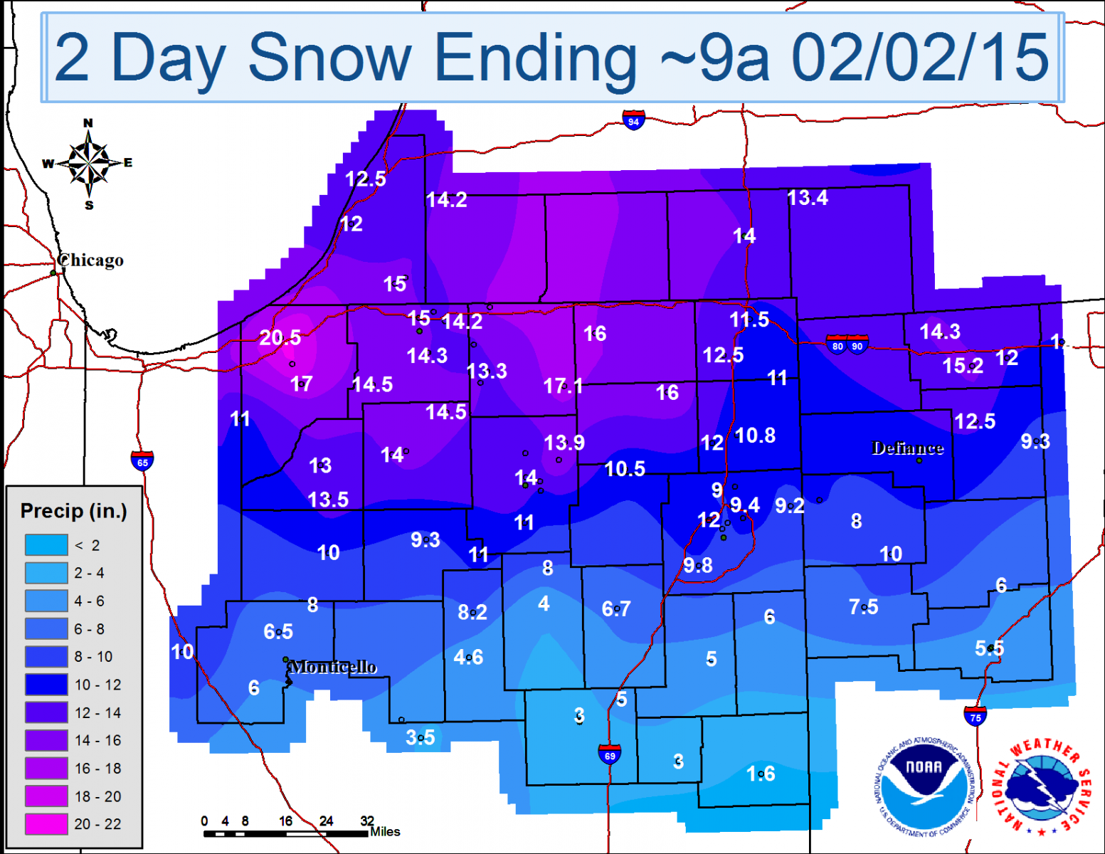
| Snowfall Map | ||
Light snow began to move in from west to east during the evening hours of January 31st. During the early morning hours of February 1st, the snow began to mix with rain, with all rain or drizzle in many locations by the daylight hours generally along and south of US-24, resulting in lower overall storm total snow amounts. However, by early afternoon, all locations switched over to snow, which became locally heavy at times from mid afternoon into the early evening hours. North of US-24, snow persisted through much of the daylight hours of February 1st with many areas seeing snowfall rates of 1 to 2 inches per hour from late morning into mid afternoon. Winds began to pickup during the late afternoon and evening hours, causing blowing and drifting snow.
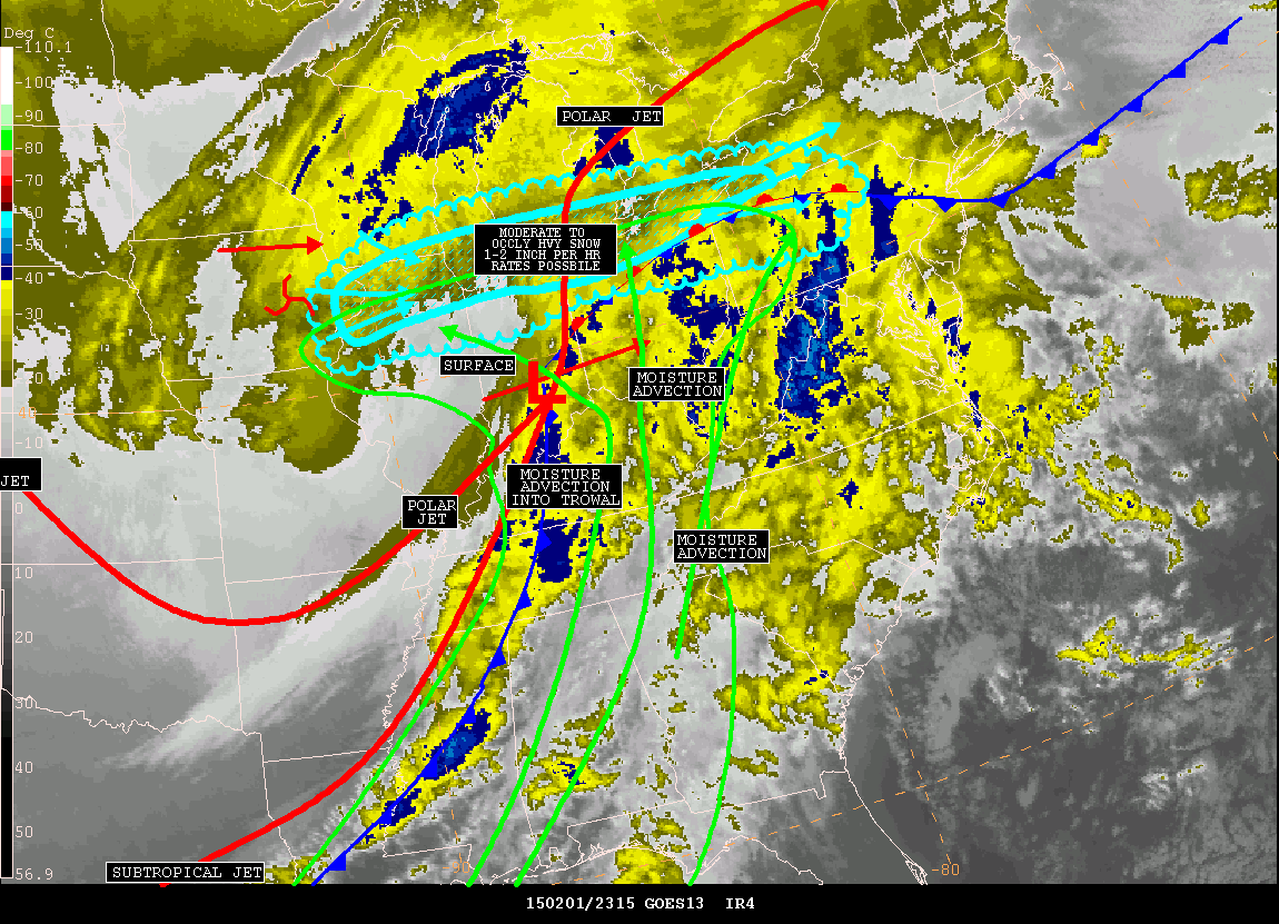
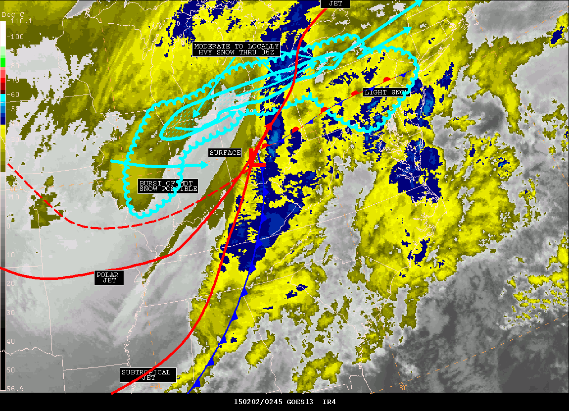
WV imagery (Fig 1 below) set the stage for a significant winter storm ahead of a potent northern stream shortwave disturbance, denoted by black X over eastern Nebraska. A large sub-tropical moisture plume (precipitable water analysis in inches, cyan contours) associated with a southern stream shortwave disturbance over northwest Mexico became entrained into the northern wave and was advected northward overtop a retreating polar airmass. Normal precipitable water values for this time of year are around 0.25" but increased to 0.75" across central Indiana by the afternoon of February 1st. This led to a long duration of sustained signficant moisture advection known as a warm conveyor belt into a retreating shallow cold layer over the Great Lakes and Ohio Valley. Light snow developed quickly the night of January 31st and became heavy the the morning of February 1st timed with maximizing moisture advection and further intensified through the afternoon and evening of the 1st when snowfall rates of 1-2" per hour were observed.
 |
| Fig 1 7 am EST Feb 1, 2015 water vapor/precipitable water analysis |
 |
|
| Feb 1 333 pm EST Satellite Precipitation Estimate Message | Feb 1 640 pm EST Satellite Precipitation Estimate Message |
 |
 |
| Feb 1 949 pm EST Satellite Precipitation Estimate Message | Feb 1 843 am EST Storm Prediction Mesoscale Discussion |
|
|
| Feb 1 235 pm EST Storm Prediction Mesoscale Discussion |
Light snow developed late Saturday night with most locations experiencing accumulations of 1 to 3 inches by daybreak Sunday. The intensity of the snow rapidly increased during the morning hours Sunday, with a particularly intense snow band from northwest Indiana into far north central Indiana. Moderate to heavy snow continued through the day, and the focus for the heaviest snow shifted into southern lower Michigan Sunday evening before tapering off. The following shows the radar evolution for the entire snowstorm spanning from late Saturday evening through late Sunday night.
Below are selected snowfall reports received during the event. The NWS would like to thank spotters, emergency management, the public, cooperative observers, CoCoRaHS observers, broadcast media, and amateur radio operators for providing valuable reports during this event.
| Location | Total Snowfall Amount |
| Buchanan, MI 1.4 ESE | 21.0 |
| La Porte, IN 1.6 SW | 20.9 |
| Trail Creek, IN 4.5 ESE | 20.5 |
| Plymouth, IN 2.6 N | 19.6 |
| Leesburg, IN 6.7 ESE | 17.2 |
| Millersburg, IN 0.5 SW | 17.1 |
| Springville, IN 1 ESE | 17 |
| Kingsbury, IN 1 N | 17 |
| Simonton Lake, IN | 16.3 |
| Plymouth, IN | 16.2 |
| Moscow, MI 1.0 NE | 16.0 |
| Shipshewana, IN | 16 |
| Kendallville, IN 4.5 NW | 16 |
| Paw Paw, IN 3.6 NNE | 15.8 |
| Goshen, IN 1.2 WNW | 15.3 |
| Walkerton, IN 5.7 ENE | 15.2 |
| Wauseon, OH | 15.2 |
| Roseland, IN | 15 |
| Buchanan, MI 1.4 ESE | 15 |
| Angola, IN | 14.9 |
| Syracuse, IN 0.9 SW | 14.9 |
| Bremen, IN | 14.5 |
| North Liberty, IN | 14.5 |
| South Bend, IN 4.5 SE | 14.3 |
| Wauseon, OH 9.0 NW | 14.3 |
| Wakarusa, IN 0.3 WSW | 14.2 |
| Mishawaka, IN 3.0 N | 14.2 |
| Niles, MI 2.7 W | 14.2 |
| Dowagiac, MI 5.3 NNW | 14.2 |
| Warsaw, IN 1.4 N | 14 |
| Plymouth, IN 2.5 WSW | 14 |
| Coldwater, MI | 14 |
| North Webster, IN 2.3 N | 13.9 |
| South Bend, IN 4.6 SE | 13.7 |
| Elkhart, IN 4.8 SW | 13.5 |
| De Motte, IN 1.2 SSW | 13.5 |
| Bass Lake, IN | 13.5 |
| Litchfield, MI 0.3 ENE | 13.4 |
| Wakarusa, IN 2.4 NNE | 13.3 |
| Knox, IN | 13 |
| De Motte, IN 0.8 NNW | 12.5 |
| Leesburg, IN 0.1 WNW | 12.5 |
| Hudson, IN 4.6 N | 12.5 |
| Benton Harbor, MI | 12.5 |
| Napoleon, OH 0.6 WSW | 12.5 |
| Warsaw, IN 2.7 ENE | 12.4 |
| Granger, IN 2.9 W | 12.4 |
| Leo, IN 2.2 NW | 12.3 |
| Wallen, IN 2.0 S | 12 |
| Garrett, OH | 12 |
| Stevensville, MI 1.7 SSE | 12 |
| Delta, OH | 12 |
| Fort Wayne, IN 7.0 NE | 11.5 |
| Angola, IN 4.1 N | 11.5 |
| Winona Lake, IN 1.1 E | 11.2 |
| Akron, IN | 11 |
| Claypool, IN 1.2 E | 11 |
| Wanatah, IN 2 WNW | 11 |
| Auburn, IN 0.8 NE | 10.8 |
| Antwerp, OH | 10.6 |
| Columbia City, IN 8.4 N | 10.5 |
| Grover Hill, OH | 10 |
| (W9OPR)Wheatfield, IN 1.4 ENE | 10 |
| Winamac, IN | 10 |
| Fort Wayne Airport | 9.8 |
| Fort Wayne, IN 4.1 NE | 9.8 |
| De Motte, IN 4.1 SW | 9.5 |
| Fort Wayne, IN | 9.4 |
| Rochester, IN 2.4 NW | 9.3 |
| McClure, OH 3.4 SSE | 9.3 |
| Woodburn, IN 3 N | 9.2 |
| Fort Wayne, IN 2.6 NE | 9.1 |
| Huntertown, IN 2.6 ESE | 9 |
| De Motte, IN 5.9 S | 9 |
| Denver, IN 1.3 NE | 8.2 |
| Headlee, IN | 8 |
| North Manchester, IN | 8 |
| Paulding, OH | 8 |
| Van Wert, OH | 7.5 |
| Huntington, IN 0.3 W | 6.7 |
| Monticello, IN 5.5 NNW | 6.5 |
| Chalmers, IN 5 W | 6 |
| Decatur, IN 1 N | 6 |
| Columbus Grove, OH | 6 |
| Lima, OH 1.0 W | 5.5 |
| Young America | 5.4 |
| Van Buren, IN | 5 |
| Atlanta 4.1 ENE | 5 |
| Bluffton 0.9 SE | 5 |
| Peru, IN | 4.6 |
| Hartford City, IN 4.0 ESE | 3 |
| Marion, IN 2 N | 3 |
| Portland, IN 2.3 S | 1.6 |
| Marion, IN 4.2 SSE | 1.5 |
Updated 2/3/2015
LF/EB/PBM/TH