November 13-14 Lake Effect Snow Event
A strong cold front marched across the eastern United States on November 11th marking the beginning of a pattern change which would bring cold Canadian air into the United States for the first time this winter season. This arctic airmass spread across the entire eastern half of the United States with below zero temperatures recorded across much of the Rockies and High Plains. As this cold airmass moved over the warm Great Lakes, the lake effect snow machine initiated on the morning of November 13th.
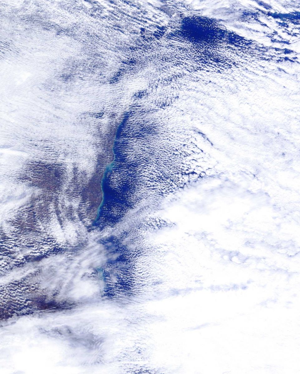
Initially the lake effect snow bands were unorganized. However one dominant intense band developed just north of South Bend with observed snowfall rates of 2 and 3 inches per hour. South Bend received 6 inches of snow in a 6 hour period with 4.5 inches falling in less than 2 hours.
This intense lake effect snow band dissipated and was replaced with multiple bands of light to moderate snow which continued across Michiana through the evening. Another intense dominant band developed and targeted the same area during the late evening hours. This band dropped snow at a rate of 1 to 2 inches per hour for several hours before dissipating again early Friday morning.
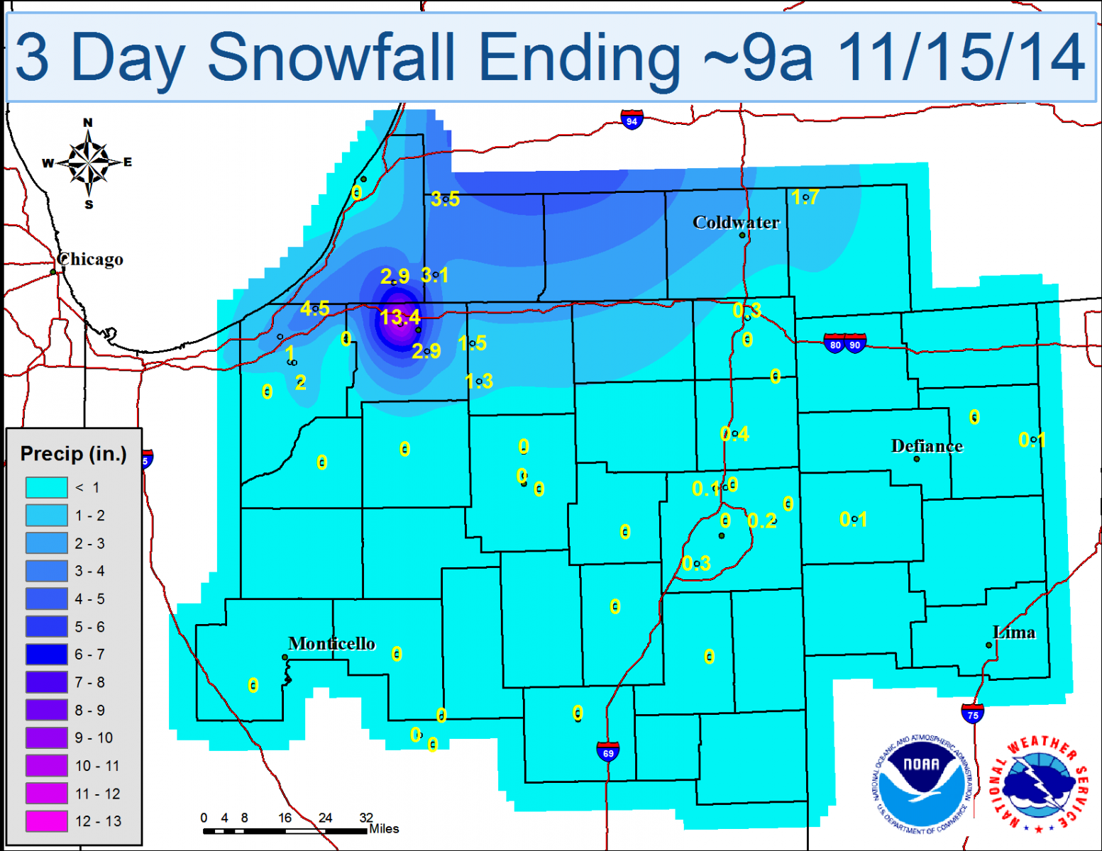
In the end, most of the lake effect zones ended up between 1 and 4 inches of snow. The exception was a narrow swath between New Carlisle and the northern portion of South Bend where a few locations received over 1 foot of snow! The small scale banding effects of lake effect snow continue to make forecasting these narrow swaths of higher snow amounts very difficult even as our understanding of lake effect snow processes continue to grow.
This map shows the snowfall totals observed for the duration of the event.
| Location | Value |
| SOUTH BEND ASOS | 13.4 |
| GRANGER | 7.5 |
| ROLLING PRARIE | 5.0 |
| GRANGER 2.9 W | 4.6 |
| BUCHANAN 1.4 ESE | 4.5 |
| NEW CARLISLE 7.3 W | 4.5 |
| DOWAGIAC | 3.5 |
| SOUTH BEND 4.5 SE | 3.0 |
| SOUTH BEND 4.6 SE | 2.8 |
| HANOVER 3.8 W | 2.4 |
| (N9ROM)TRAIL CREEK 4.5 ESE | 2.0 |
| DOWAGIAC 5.3 NNW | 2.0 |
| KINGSBURY 0.3 WNW | 2.0 |
| KINGSBURY 1 N | 2.0 |
| NILES 2.7 W | 2.0 |
| NILES 3.5 E | 2.0 |
| THREE RIVERS | 2.0 |
| LA PORTE 1.6 SW | 1.6 |
| ELKHART 4.8 SW | 1.5 |
| MISHAWAKA 3.9 ENE | 1.5 |
| WAKARUSA 0.3 WSW | 1.3 |
| (KA9WNQ)LA PORTE 1.7 SW | 1.0 |
| (WA9RON)LA PORTE 1.3 SSW | 1.0 |
| DOWAGIAC 1 W | 1.0 |
 |
 |
 |
 |
 |
 |
 |
Bentley/Logsdon

