A strong low pressure system moving through the eastern United States late Tuesday evening, November 26th into early Thursday morning, November 28th, helped bring another surge of cold area into the Great Lakes region. As the cold air funneled over the warmer Lake Michigan waters from the north/northwest, heavy lake effect snow showers developed. During the day on November 27th, the event transitioned from an unorganized area of snow into a single band that persisted and moved slightly east from northern Berrien County, Michigan, southeast into St. Joseph and Marshall counties in Indiana. Highest accumulations of 10-16" were found in eastern Berrien County and western Cass County in Michigan. Accumulations upwards of 6 inches were found south of this area in Marshall and St. Joseph counties in Indiana.This single band produced an impressive gradient from no snow to over a foot in less than a 30 mile span!
Here is a loop of hourly radar images from approximately 7 pm on November 26th until 7 pm on November 27th when a majority of the snow fell.

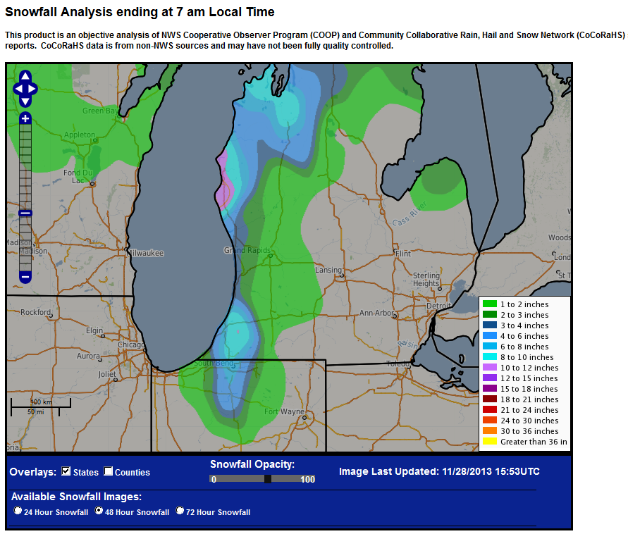
The map below shows regional snowfall totals for the event. North/northwesterly winds allowed for a long fetch connected with Lake Superior which only enhanced snowfall duration and amounts.
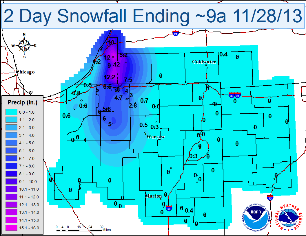
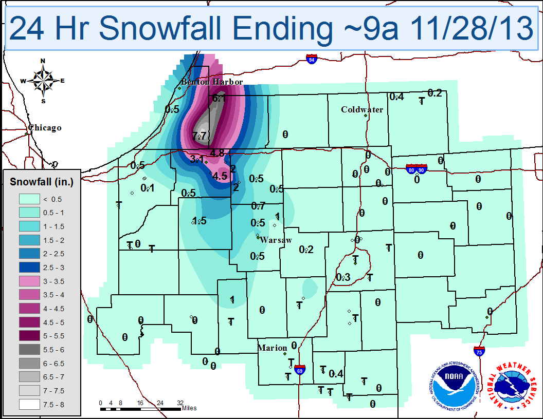
The maps and table below show storm total (48 hour) snowfall and 24 hour totals from November 26th through the morning of the 28th.
 |
|
 |
 |
| Location | Storm Total Snowfall | Time/Date |
| INDIANA | ||
| ...LA PORTE COUNTY... | ||
| FISH LAKE | 5 | 115 PM 11/27 |
| ...MARSHALL COUNTY... | ||
| PLYMOUTH | 6.5 | 700 AM 11/28 |
| 1 WSW TYNER | 6 | 705 AM 11/27 |
| 6 NW PLYMOUTH | 5.3 | 600 AM 11/27 |
| ...ST. JOSEPH COUNTY... | ||
| 1 NNE GEORGETOWN | 12.5 | 252 PM 11/27 |
| 2 SE GEORGETOWN | 9 | 323 PM 11/27 |
| 2 NE SOUTH BEND | 8.5 | 600 PM 11/27 |
| 2 ENE GEORGETOWN | 8.3 | 700 AM 11/28 |
| 3 W GRANGER | 8.3 | 800 AM 11/28 |
| ARGOS | 8 | 158 PM 11/27 |
| 1 E MISHAWAKA | 8 | 518 PM 11/27 |
| GEORGETOWN | 8 | 220 PM 11/27 |
| 1 SE GEORGETOWN | 7 | 430 PM 11/27 |
| 4 NW SOUTH BEND | 6.7 | 700 AM 11/28 |
| 3 NNE LYDICK | 6.5 | 200 PM 11/27 |
| 3 N TEEGARDEN | 6.3 | 700 AM 11/28 |
| WALKERTON | 6 | 1100 AM 11/27 |
| 6 ENE WALKERTON | 5.8 | 700 AM 11/27 |
| 6 SE MISHAWAKA | 5.5 | 800 AM 11/28 |
| 5 SSW OSCEOLA | 5.2 | 700 AM 11/28 |
| 3 SW JIMTOWN | 4.4 | 837 PM 11/27 |
| 1 S GRANGER | 4 | 725 PM 11/27 |
| MICHIGAN | ||
| ...BERRIEN COUNTY... | ||
| COLOMA | 16 | 235 PM 11/27 |
| 4 SSE SPINKS CORNERS | 15 | 515 PM 11/27 |
| 3 W NILES | 13.7 | 800 AM 11/28 |
| 1 ESE BUCHANAN | 12.2 | 300 PM 11/27 |
| BERRIEN CENTER | 12 | 334 PM 11/27 |
| SODUS | 12 | 500 PM 11/27 |
| BERRIEN SPRINGS | 11 | 835 AM 11/28 |
| BENTON HARBOR | 7 | 213 PM 11/27 |
| ...CASS COUNTY... | ||
| 1 ESE MAGICIAN LAKE | 11.3 | 800 AM 11/28 |
| DOWAGIAC | 9.3 | 430 PM 11/27 |
| EDWARDSBURG | 7.5 | 720 PM 11/27 |
Published 11/28/2013 1 PM
CEO

