A strong cold front moved through the local area during the early afternoon hours on Wednesday July 10th, 2013. Moderate to extreme instability ahead of the cold front allowed for thunderstorms to fire and rapidly become severe as they merged into a line of thunderstorms that moved east/southeast from northern Indiana over into northwest Ohio. This line of severe thunderstorms continued east into Pennsylvania before weakening on the East Coast.
Below are animated radar loops of base (0.5 degree) reflectivity and velocity from approximately 12 pm to 3 pm EDT. Click on the thumbnails to view a higher resolution.
 |
 |
| Base (0.5 degree) Reflectivity | Base (0.5 degree) Velocity |
Several areas in the Northern Indiana County Warning Area (CWA) were hard-hit by straight line winds in excess of 60-80 mph.This caused widespread tree and power line damage in some locations (such as Cass, Miami, and Huntington counties in Northern Indiana and Defiance and Henry counties in NW Ohio). A brief EF1 tornado was also confirmed on the south side of Peru, Indiana. For more details on the tornado, see the story below.
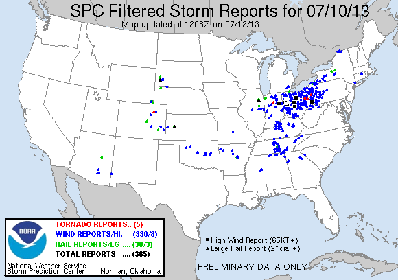
The image below shows the local storm reports we received during the event. Click for interactive map of all severe weather reports for July 10, 2013
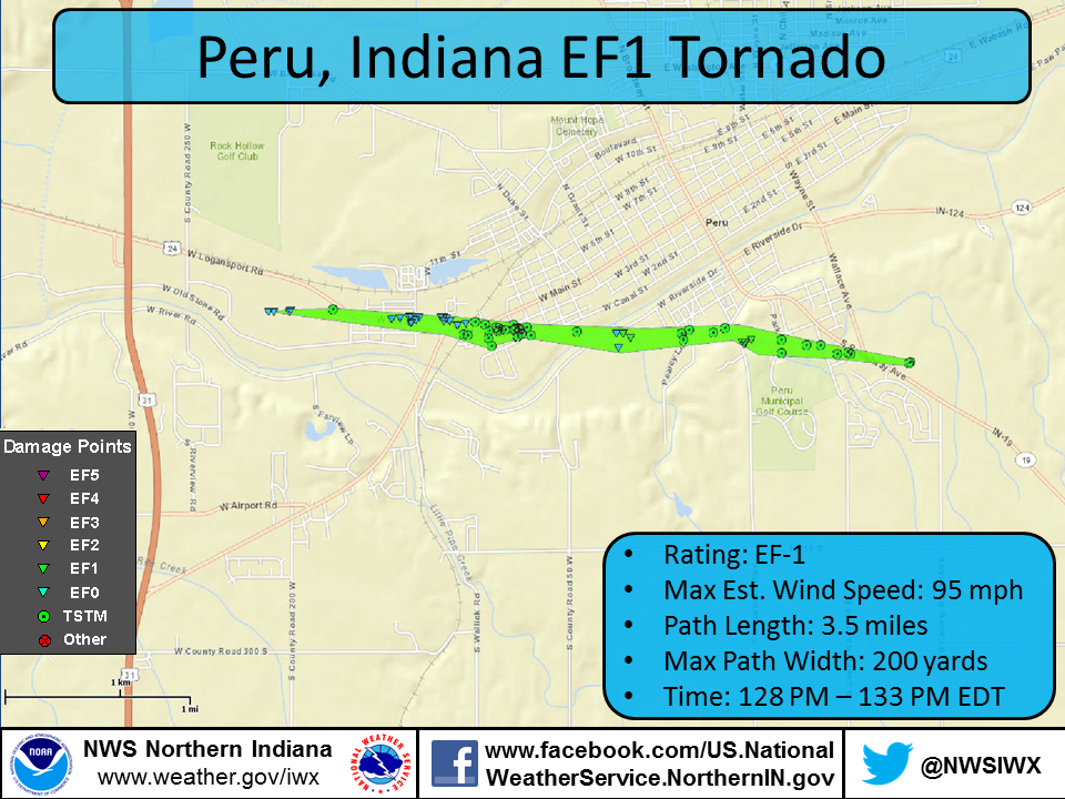
A National Weather Service damage survey team confirmed that the extensive damage to the south side of Peru was caused by an EF-1 tornado with estimated winds up to 95 mph. The tornado touched down in a corn field south of US-24 to the west of CountryMark refinery around 1:28 pm EDT on Wed. July 10, 2013. The tornado then traveled along US24 between S Cook St. and S Park Ave. Extensive tree damage was noted along the path with numerous uprooted or snapped trees. Minor roof or structural damage was noted in several houses where trees had fallen onto the roofs. Several businesses sustainted minor facade or roof damage. The tornado then crossed the Wabash river and then uprooted 30 to 40 large, healthy trees in Maconaquah park. The tornado continued across State Road 19 between Astrup Dr. and Parkway Terrace and then hit a grove of trees behind a church before lifting shortly thereafter around 1:33 PM EDT.
Damage Survey Results
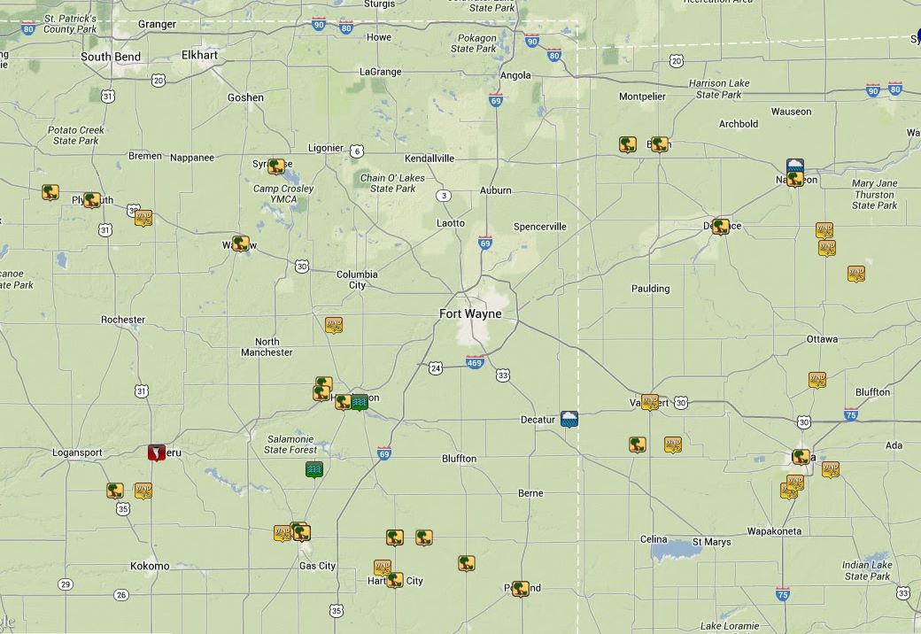
Here is an interactive map of the tornado path. Click on each damage point to see details, rating of the damage, and pictures.
An album of damage pictures taken by the emergency manager can be seen on our Facebook page by clicking here.
This four panel radar image from the KIWX WSR-88D is from 1:29 PM EDT on July 10th, 2013, one minute after the tornado touched down in Peru. The 0.5° reflectivity shows a collision between the line of storms moving southeast and the area of storms moving northeast. The lowest scan of the radar is approximately 3375 ft. above ground level. The 0.5° storm relative velocity shows a small downburst located southwest of Peru, pushing southeast. At the leading edge of this downburst, weak cyclonic rotation is noted over the area where the tornado occurred. While the reflectivity and storm relative velocity images show a small amount of evidence that a tornado could be occurring, the dual-pol products provide more supports. The 0.5° differential reflectivity (ZDR) and correlation (CC) products show a relative minimum value co-located with the weak rotation. This lowering in CC and ZDR is indicative of debris lofted into the air, which co-located with the weak rotation, is indicative of a weak tornado debris signature (TDS). To learn more about dual-pol radar, click here.
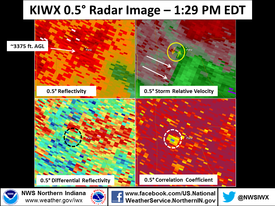
The very next radar scan came at 1:33 PM EDT, the same minute that the tornado lifted. The storm relative velocity shows a broadening and weakening of any rotation. CC and ZDR products continue to indicate debris lofted into the air southwest of Peru. The tornado dropped and lifted in about the same amount of time that it takes the radar to do a full volume scan!

Below is a longer loop of these four products. Note the tornado occurred when the storms moving southeast collided with the storms that were moving northeast.

Bentley/Obergfell/Greenawalt

